
User:AussieLegend/Australian place article starter
| This is a Wikipedia user page. This is not an encyclopedia article or the talk page for an encyclopedia article. If you find this page on any site other than Wikipedia, you are viewing a mirror site. Be aware that the page may be outdated and that the user in whose space this page is located may have no personal affiliation with any site other than Wikipedia. The original page is located at https://en.wikipedia.org/wiki/User:AussieLegend/Australian_place_article_starter. |
Home Talk Contributions Projects (tm – ) Miscellaneous
pages Userboxes Cheatsheet Vandals, bad
sources etc TV programs
pages Userboxes Cheatsheet Vandals, bad
sources etc TV programs
Projects page Project 01 Project 02 Project 03 Project 04 Project 05 Australian place article
starter (WP:IAP) Template
maintenance Hunter Region Port Stephens
Council
starter (WP:IAP) Template
maintenance Hunter Region Port Stephens
Council
| This is not a Wikipedia article: It is an individual user's work-in-progress page, and may be incomplete and/or unreliable. For guidance on developing this draft, see Wikipedia:So you made a userspace draft. Find sources: Google (books · news · scholar · free images · WP refs) · FENS · JSTOR · TWL |
| Infobox partially filled with typical data and examples New South Wales | |
|---|---|
 Infobox partially filled with typical data and examples A caption is only needed if the map is not self explanatory | |
| Coordinates | 32°45′41.3″S 151°44′38.6″E / 32.761472°S 151.744056°E |
| Population | 1 (2011 census)[1] (normally not used by me) |
| • Density | [Note 1] |
| Time zone | AEST (UTC+10) |
| • Summer (DST) | AEDT (UTC+11) |
| Location |
|
| LGA(s) | Port Stephens Council[2] |
| Region | Hunter[2] |
| County | NSW Geographical Names BoardGloucester[3] |
| Parish | [3] |
| State electorate(s) | Port Stephens[4] |
| Federal division(s) | Paterson[5] |

Text
Image gallery
[edit]-
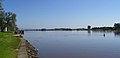 Raymond Terrace foreshore on the Hunter River downstream view

Notes
[edit]- ^ This is the average density of the actual township where most of the population lives, not the average for the whole area which is considerably lower at 328/km2 (850/sq mi). This lower figure does not accurately represent the population density in either the town itself or the surrounding rural area where the population density is actually closer to 13/km2 (34/sq mi).
- ^ Raymond Terrace is primarily flat however it does have some elevated areas. Average elevation of the suburb as shown on 1:100000 map 9232 NEWCASTLE.
- ^ Area calculation is based on 1:100000 map 9232 NEWCASTLE.
References
[edit]- ^ Australian Bureau of Statistics (31 October 2012). "Raymond Terrace (State Suburb)". 2011 Census QuickStats. Retrieved 23 July 2018.
- ^ a b "Suburb Search - Local Council Boundaries - Hunter (HT) - Port Stephens". New South Wales Division of Local Government. Retrieved 23 July 2018.
- ^ a b "Raymond Terrace". Geographical Names Register (GNR) of NSW. Geographical Names Board of New South Wales. Retrieved 23 July 2018.
- ^ "Port Stephens". New South Wales Electoral Commission. 24 September 2012. Retrieved 23 July 2018.
- ^ "Paterson". Australian Electoral Commission. 26 July 2012. Retrieved 23 July 2018.
- ^ a b c Bureau of Meteorology
- "Suburb Search - Local Council Boundaries - Hunter (HT)". New South Wales Department of Local Government. Retrieved 23 July 2018.
- "Raymond Terrace". Land and Property Management Authority - Spatial Information eXchange. New South Wales Land and Property Information. Retrieved 23 July 2018.
- "Raymond Terrace". Australian Explorer. Retrieved 23 July 2018.
- "Nelson Bay (Nelson Head)". Climate statistics for Australian locations. Bureau of Meteorology. Retrieved 23 July 2018.
- "Raymond Terrace (Wallaroo State Forest)". Climate statistics for Australian locations. Bureau of Meteorology. Retrieved 23 July 2018.
- "Williamtown RAAF". Climate statistics for Australian locations. Bureau of Meteorology. Retrieved 23 July 2018.
- "Paterson (Tocal AWS)". Climate statistics for Australian locations. Bureau of Meteorology. Retrieved 23 July 2018.
- "Newcastle Nobbys Signal Station AWS". Climate statistics for Australian locations. Bureau of Meteorology. Retrieved 23 July 2018.
Compass directions
[edit]| Compass directions (degrees) | |||
|---|---|---|---|
| Direction | From | To | Centre |
| N | 348.75 | 11.25 | 0 |
| NNE | 11.25 | 33.75 | 22.5 |
| NE | 33.75 | 56.25 | 45 |
| ENE | 56.25 | 78.75 | 67.5 |
| E | 78.75 | 101.25 | 90 |
| ESE | 101.25 | 123.75 | 112.5 |
| SE | 123.75 | 146.25 | 135 |
| SSE | 146.25 | 168.75 | 157.5 |
| S | 168.75 | 191.25 | 180 |
| SSW | 191.25 | 213.75 | 202.5 |
| SW | 213.75 | 236.25 | 225 |
| WSW | 236.25 | 258.75 | 247.5 |
| W | 258.75 | 281.25 | 270 |
| WNW | 281.25 | 303.75 | 292.5 |
| NW | 303.75 | 326.25 | 315 |
| NNW | 326.25 | 348.75 | 337.5 |
Climate data
[edit]This section is not to be included in the article. The appropriate data is to be transferred to the article.
- "Nelson Bay (Nelson Head)". Climate statistics for Australian locations. Bureau of Meteorology. Retrieved 23 July 2018.
| |||||||||||||||||
- "Raymond Terrace (Wallaroo State Forest)". Climate statistics for Australian locations. Bureau of Meteorology. Retrieved 23 July 2018.
| North Error: |state= not defined (help) | |||||||||
|---|---|---|---|---|---|---|---|---|---|
| |||||||||
Error: |type= not defined (help) | |||||||||
- "Williamtown RAAF". Climate statistics for Australian locations. Bureau of Meteorology. Retrieved 23 July 2018.
| |||||||||||||||||
- "Paterson (Tocal AWS)". Climate statistics for Australian locations. Bureau of Meteorology. Retrieved 23 July 2018.
| |||||||||||||||||
- "Newcastle Nobbys Signal Station AWS". Climate statistics for Australian locations. Bureau of Meteorology. Retrieved 23 July 2018.
| Southern Error: |state= not defined (help) | |||||||||
|---|---|---|---|---|---|---|---|---|---|
| |||||||||
Error: |type= not defined (help) | |||||||||
Undecided