User:Ceveris/sandbox
Template:Infobox_historic_site
This article needs additional citations for verification. (July 2015) |
| Ceveris/sandbox | |
|---|---|
 Château de Saint-Élix | |
| Coordinates | 43°16′41″N 1°08′11″E / 43.27806°N 1.13639°E |
| Built | 1540 to 1548 |
| Original use | Castle |
| Current use | Private |
| Owner | Private |
| Designated | 1927 and 1994 |
| Château de Saint-Élix | |
|---|---|
 Château de Saint Elix | |
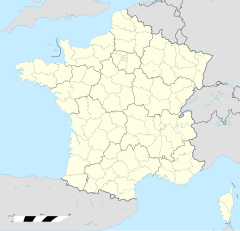
Location within Haute-Garonne | |
| General information | |
| Type | Castel |
| Architectural style | Renaissance |
| Location | Saint-Èlix-le-Château, Haute-Garonne, France |
| Country | France |
| Coordinates | 43°16′41″N 1°08′11″E / 43.27806°N 1.13639°E |
| Construction started | 1540 |
| Inaugurated | 1548 |
| Owner | private |
| Design and construction | |
| Architect(s) | Laurent Clary |
| Designated | 1927 and 1994 |
- Not to be confused with Château de Saint-Élix-Séglan
The Château de Saint-Élix is a 16th-century castle in the commune of Saint-Élix-le-Château in the Haute-Garonne département of France.
Built in the 1540s, it is privately owned and has been listed since 1927 as a monument historique by the French Ministry of Culture. Of note are the orangery, stables, walls and pigeon loft.
See also[edit]
Sources[edit]
- www.culture.gouv.fr, accessed 17 March 2008
External links[edit]
Chart[edit]
A chart:
10
20
30
40
50
60
1940
1950
1960
1970
1980
1990
Another chart:
100,000
200,000
300,000
400,000
500,000
1990
1995
2000
2005
2010
2015
2020
A third Chart:
Number of reports received
| Graphs are unavailable due to technical issues. There is more info on Phabricator and on MediaWiki.org. |
Number of reports received by VAERS (until 2 July 2021)[1]
- ^ "VAERS Data". VAERS.


