User:ChachoWiki/Kelp Harbour
| Kelp Harbour | |
|---|---|
| Puerto Cochayuyo | |
| Basin countries | |
Categoría:Wikipedia:Artículos con coordenadas en Wikidata
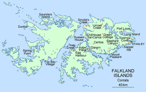
Kelp Harbour (in Spanish: Puerto Cachiyuyo ) is a bay located in the west cost of East Falkland, in the Falkland Islands. It is located in the Bay of San Carlos, between the Dos Lomas peninsula, to the north and the peninsula of hope, to the south. The settlement of Dos Lomas is close by.[1]

Here workers labored midway through the century XIX, in pens made by the gauchos from the Río de la Plata who arrived to the islands during the decade of 1820.
See also[edit]
- ^ "Carta H-411, Isla Soledad (esc. 1:200.000 - 76 cm x 110 cm)" (Mapa con toponimia en castellano). Depositado por la Argentina en la Organización de las Naciones Unidas. Buenos Aires: Servicio de Hidrografía Naval. 1969, reimpresión julio de 1990.
{{cite journal}}: Check date values in:|year=(help)
Data: [[Category:Bays of the Falkland Islands]] [[Category:East Falkland]]
