User:ElnF94/sandbox
Note:
Additions to other articles will include a mention of the park on the pages of the Blanche River ("Kap-Kig-Iwan park is located on the Englehart River, a tributary of the Blanche River"
Kap-Kig-Iwan Provincial Park[edit]
| Kap-Kig-Iwan Provincial Park | |
|---|---|
IUCN category IV (habitat/species management area) | |
 | |
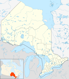
| Location | Timiskaming District, Ontario, Canada |
| Nearest city | Englehart |
| Coordinates | 47°47′46″N 79°53′13″W / 47.79611°N 79.88694°W[1] |
| Area | 325 hectares (803 acres) |
| Established | 1957 |
| Governing body | Ontario Parks |
| www | |
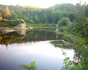
Kap-Kig-Iwan Provincial Park is a protected area in the incorporated townships of Charlton and Dack[2] and Evanturel[3] in Timiskaming District in Northeastern Ontario, Canada.[1] The 325-hectare (803-acre) park[4] is located along the Englehart River,[5] a tributary of the Blanche River off Lake Temiskaming.
Located off Ontario Highway 11, the park is about 2 kilometres (1.2 mi) south of the town of Englehart, Ontario. It is classified as a Natural Environment park.[5]
Kap-Kig-Iwan is well known for its scenic views of waterfalls such as Horseshoe Falls. It is located partially on the Canadian Shield and partially on the Clay Belt, making it geologically significant remnant from the area's last glacial period.[5]
History[edit]
Established in 1957, the park was formed around private land that was present nearby. The park was expanded in 2000 to include several more additions. Kap-Kig-Iwan was expanded in 2006 to incorporate several more areas of crown land within the boundaries of the park. It was further expanded to encourage tourism, protection, heritage appreciation, and recreation.[6]
An old-growth forest is present within the park. Most of the forest contained within the bounds of the park was burned down in the Great Fire of 1922 that devastated the local area. The fire did not burn the entire area of the park, and several old-growth trees from prior to the fire are present in the areas of the park that did not burn down. The northern edge of the fire ended in this park.[5]
The park was closed for camping in 2012 along with nine other small provincial parks due to a low occupancy rate. This was an unpopular choice with many of the locals that led to significant outcry from nearby residents and friends of the provincial park.[7]
The park has since be reopened for day use camping. During the Covid-19 pandemic the park was closed temporarily to visitors. It was reopened to the public for more restricted use on June 26, 2020 with reduced services for the rest of the season.[8]
Recreation[edit]
Kap-Kig-Iwan is a provincial park of Ontario and operates seasonally, with camping available in the summer months. Kap-Kig-Iwan has both electric and non-electric campsites. During the summer months the park supports camping, hiking, canoeing, and backpacking, with ample opportunity for birdwatching.[9]
While the park is not available to camp in during the winter months, it is utilized year-round by recreational enthusiasts. The park is used by cross-country skiers consistently, with the hiking trails doubling as ski trails in the winter months.[9] The Englehart Nordic Ski Club maintains over 12km of trails during the winter months at Kap-Kig-Iwan and operates a lodge there. This lodge is staffed by volunteers.[10]
Trails[edit]
- The Uplands Circle Trail is utilized by both summer and winter hikers and is 2.5 km long.[11]
- The Hell's Gate trail branches off from the Uplands Circle Trail and offers scenic rapid views. It is 2.5km long.[11]
- The Englehart River Trail is 5.7km long and travels along the banks of the Englehart River. It is considered a technically challenging but rewarding hike.[11]
- The Englehart River Canoe Trail is an established canoe route that passes through this park.[5]
References[edit]
- ^ a b "Kap-Kig-Iwan Provincial Park". Geographical Names Data Base. Natural Resources Canada. Retrieved 2014-05-15.
- ^ "Dack" (PDF). Geology Ontario - Historic Claim Maps. Ontario Ministry of Northern Development, Mines and Forestry. Archived from the original (PDF) on 2014-05-17. Retrieved 2014-05-15.
- ^ "Evanturel" (PDF). Geology Ontario - Historic Claim Maps. Ontario Ministry of Northern Development, Mines and Forestry. Archived from the original (PDF) on 2014-05-17. Retrieved 2014-05-15.
- ^ "Kap-Kig-Iwan Park". Town of Englehart. 2013. Retrieved 2014-05-15.
- ^ a b c d e "Kap-Kig-Iwan Provincial Park Management Plan" (PDF). Ontario Ministry of Natural Resources. 1984. Retrieved 2014-05-15.
- ^ Parks Canada (2006-12-02). "Kap-Kig-Iwan Provincial Park Management Plan: Amendment". Retrieved 2020-12-02.
{{cite web}}: CS1 maint: url-status (link) - ^ Cowan, Liz (2012-10-19). "Nine Northern provincial parks to close for camping". Northern Ontario Business News. Retrieved 2020-12-02.
{{cite web}}: CS1 maint: url-status (link) - ^ Editorial Staff (2020-06-23). "Kap-Kig-Iwan opening for camping". The Temiskaming Speaker. Retrieved 2020-12-02.
{{cite web}}: CS1 maint: url-status (link) - ^ a b "Kap-Kig-Iwan Provincial Park". Ontario Parks. 2020-10-06. Retrieved 2020-10-06.
{{cite web}}: CS1 maint: url-status (link) - ^ Township of Evanturel. "Englehart Nordic Ski Club- Kap-Kig-Iwan Provincial Park" (PDF). Retrieved 2020-11-29.
{{cite web}}: CS1 maint: url-status (link) - ^ a b c "Kap-Kig-Iwan: Discover Your Perfect Hike to See Waterfalls". Northern Ontario Travel. 2015-03-11. Retrieved 2020-12-02.
Other map sources:
- Map 15 (PDF) (Map). Official road map of Ontario. Ministry of Transportation of Ontario.
- Restructured municipalities - Ontario map #3 (Map). Restructuring Maps of Ontario. Ontario Ministry of Municipal Affairs and Housing. 2006. Retrieved 2014-05-15.
External links[edit]
 | This is a user sandbox of ElnF94. You can use it for testing or practicing edits. This is not the sandbox where you should draft your assigned article for a dashboard.wikiedu.org course. To find the right sandbox for your assignment, visit your Dashboard course page and follow the Sandbox Draft link for your assigned article in the My Articles section. |

