
User:Gazamp/Safekeeping
| {{{1}}} |
|2=
|2=

The Andes (/ˈændiːz/ AN-deez), Andes Mountains or Andean Mountain Range (Spanish: Cordillera de los Andes; Quechua: Anti) are the longest continental mountain range in the world, forming a continuous highland along the western edge of South America. The range is 8,900 km (5,530 mi) long and 200 to 700 km (124 to 435 mi) wide (widest between 18°S and 20°S latitude) and has an average height of about 4,000 m (13,123 ft). The Andes extend from South to North through seven South American countries: Argentina, Chile, Bolivia, Peru, Ecuador, Colombia, and Venezuela.
Along their length, the Andes are split into several ranges, separated by intermediate depressions. The Andes are the location of several high plateaus—some of which host major cities such as Quito, Bogotá, Cali, Arequipa, Medellín, Bucaramanga, Sucre, Mérida, El Alto, and La Paz. The Altiplano Plateau is the world's second highest after the Tibetan Plateau. These ranges are in turn grouped into three major divisions based on climate: the Tropical Andes, the Dry Andes, and the Wet Andes. (Full article...)
Selected general articles
-

Huayna Potosí is a mountain in Bolivia, located near El Alto and about 25 km north of La Paz in the Cordillera Real.
Huayna Potosí is the closest high mountain to La Paz. Surrounded by high mountains, it is roughly 15 miles due north of the city, which makes this mountain the most popular climb in Bolivia. The normal ascent route is a fairly straightforward glacier climb, with some crevasses and a steep climb to the summit. However, the other side of the mountain—Huayna Potosí West Face—is the biggest face in Bolivia. Several difficult snow and ice routes ascend this 1,000-meter-high face. (Full article...) -
Cerro Bayo is a complex volcano on the northern part border between Argentina and Chile. It consists of four overlapping stratovolcanoes along a north–south line. The main volcano face is located on the Argentine side, thought the summit of the complex is just west of the border, in Chile. The volcano is about 800,000 years old, but it is associated with ongoing ground uplift encompassing also the more northerly Lastarria and Cordón del Azufre volcanoes. The 5,401-metre (17,720 ft) high summit is the source of two viscous dacitic lava flows with prominent levees that traveled to the north.
Elemental sulfur can be found at Bayo, both in the form of high-grade massive deposits and as extinct fumarole chimneys. The volcano formed in three separate phases that produced lava flows. One is dated to 1.6±0.4 million years ago. The volcano can bear snow in winter. The youngest dated rocks are about 23,000 years old; in 2007 a steam eruption were observed by researchers investigating nearby salt pans such as Salar Ignorado. (Full article...) -
Cotopaxi (Spanish pronunciation: [kotoˈpaksi]) is an active stratovolcano in the Andes Mountains, located near Latacunga city of Cotopaxi Province, about 50 km (31 mi) south of Quito, and 31 km (19 mi) northeast of the city of Latacunga, Ecuador. It is the second highest summit in Ecuador (after Chimborazo), reaching a height of 5,897 m (19,347 ft). Cotopaxi is among the highest active volcanoes in the world.
Cotopaxi is known to have erupted 87 times, resulting in the creation of numerous valleys formed by lahars (mudflows) around the volcano. An ongoing eruption began on 21 October 2022. (Full article...) -
El Cocuy National Park is a national park located in the Andes Mountains within the nation of Colombia. Its official name is Parque Nacional Natural El Cocuy. (Full article...) -
Volcán Marmolejo is a 6,108 m (20,039 ft) high Pleistocene stratovolcano in the Andes on the border between Argentina and Chile. It is located 9 km (6 mi) NNE of the active San José volcano, and is the southernmost 6,000 m (19,685 ft)-plus peak in the world. The Argentine portion is within the Argentinean protection area of Provincial Reserve for Multiple Use and Natural Recreation Manzano / Portillo de Piuquenes. It is on the border of two provinces: Argentinean province of Mendoza and Chilean province of Cordillera. Its slopes are within the administrative boundaries of the two cities: Argentinean city of Tunuyán and the Chilean commune of San José de Maipo. (Full article...) -
The Wet Andes (Spanish: Andes húmedos) is a climatic and glaciological subregion of the Andes. Together with the Dry Andes it is one of the two subregions of the Argentine and Chilean Andes. The Wet Andes runs from a latitude of 35°S to Cape Horn at 56°S. According to Luis Lliboutry the Wet Andes can be classified after the absence of penitentes. In Argentina well developed penitentes are found as south as on Lanín Volcano (40°S). Another difference is that the Wet Andes is largely devoid of rock glaciers. The glaciers of the Wet Andes have a far more stable line of equilibrium than those of the Dry Andes due to summer precipitations, low thermal oscillations and an overall high moisture. (Full article...) -

The Titicaca orestias, Lake Titicaca orestias, or Lake Titicaca flat-headed fish (Orestias cuvieri), also known by its native name amanto, is a likely extinct freshwater killifish from Lake Titicaca in South America. It belongs in the pupfish genus Orestias, endemic to lakes, rivers and streams in the Andean highlands. With a total length of up to 27 cm (10.6 in), it was the largest member in that genus. In the hope that an undiscovered population remains, it is listed as Data Deficient by the IUCN. Despite its common name, it is not the only Orestias from Lake Titicaca.
Its mouth was nearly turned upwards, thereby giving the flat head a concave shape. The head took up nearly a third of the whole body length. The upperside was greenish-yellow to umber. The lower jaw was black. Its scales were oddly light coloured at their centre. The scales of the young were blotched. (Full article...) -
Rondoy (possibly from Quechua runtuy: "to hail" or "to lay an egg") is a 5,870-metre-high (19,259 ft) mountain in the north of the Huayhuash mountain range in the Andes of Peru. It is located in the Ancash Region, Bolognesi Province, Pacllón District, and in the Huánuco Region, Lauricocha Province, Queropalca District. Rondoy lies north of Yerupajá and Jirishanca and southwest of Lake Mitococha. (Full article...) -
Nevado del Huila (/nɛˈvɑːdoʊ dɛl ˈwiːlə/, Spanish pronunciation: [neˈβaðo ðel ˈwila]) at 5,364 metres (17,598 ft), is the highest volcano in Colombia, located at the tripoint of the departments of Huila, Tolima and Cauca. It is visible from the city of Cali. The andesitic volcano is located on top of the Ibagué Batholith.
After being dormant for more than 500 years, the volcano showed heavy signs of activity in 2007 and 2008. As of February 20, 2007, there were more than 7000 "minor" seismic events, and a high state of alert was in place for the departments of Cauca, Huila, Caldas and Valle del Cauca. The volcano erupted twice in April 2007, once in April 2008 and again in November 2008. Any eruption would affect the small villages around the volcano, mostly Páez, where their inhabitants still have in memory the eruption of the Nevado del Ruiz volcano and the destruction of Armero. (Full article...) -
Pomerape is a stratovolcano lying on the border of northern Chile and Bolivia (Oruro Department, Sajama Province, Curahuara de Carangas Municipality). It is part of the Payachata complex of volcanoes, together with Parinacota Volcano to the south. The name "Payachata" means "twins" and refers to their appearance. It hosts glaciers down to elevations of 5,300–5,800 metres (17,400–19,000 ft), lower on the northern slope.
Pomerape is a complex of lava domes, accompanied by lava flows which were emplaced atop of the domes. It was active about 200,000 years ago. The lava domes formed first and were later buried by the actual volcanic cone, which unlike the rhyolitic-dacitic domes is formed by hornblende andesite. The "Chungará Andesites" and lava dome complex of Parinacota were laid down at this time. Pomerape is associated with an adventive vent that has erupted mafic magmas. The main cone was last active 106,000 +- 7,000 years ago, the adventive vent is dated to 205,000 ± 24,000 years ago. (Full article...) -
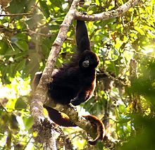
The yellow-tailed woolly monkey (Lagothrix flavicauda) is a New World monkey endemic to Peru. It is a rare primate species found only in the Peruvian Andes, in the departments of Amazonas and San Martin, as well as bordering areas of La Libertad, Huánuco, and Loreto. (Full article...) -
Pico La Concha is a mountain in the Andes of Venezuela. It has a height of 4,922 metres. (Full article...) -
Chinchillas are either of two species (Chinchilla chinchilla and Chinchilla lanigera) of crepuscular rodents of the parvorder Caviomorpha, and are native to the Andes mountains in South America. They live in colonies called "herds" at high elevations up to 4,270 m (14,000 ft). Historically, chinchillas lived in an area that included parts of Bolivia, Peru and Chile, but today, colonies in the wild are known only in Chile. Along with their relatives, viscachas, they make up the family Chinchillidae. They are also related to the chinchilla rat.
The chinchilla has the densest fur of all mammals that live on land, with around 20,000 hairs per square centimeter and 50 hairs growing from each follicle. In the water, the sea otter has a denser coat. The chinchilla is named after the Chincha people of the Andes, who once wore its dense, velvet-like fur. By the end of the 19th century, chinchillas had become quite rare after being hunted for their notably soft fur. Most chinchillas currently used by the fur industry for clothing and other accessories are farm-raised. Domestic chinchillas descended from C. lanigera are sometimes kept as pets, and may be considered a type of pocket pet. (Full article...) -
Jirishanca is a 6,094-metre-high (19,993 ft) mountain in the Huayhuash mountain range in west central Peru, part of the Andes. Other sources cite a height of 6,125 metres (20,095 ft). It is the tenth highest peak in Peru and the third in the Huayhuash range (after Yerupajá and Siula Grande). Jirishanca translates as "hummingbird bill peak". (Full article...) -

The Puracé National Natural Park (Spanish: Parque Nacional Natural Puracé) is a national park located in the Andean region of Colombia, southeast of the city of Popayán in the Cordillera Central range. Its main feature is the active stratovolcano Puracé, one of Colombia's most active volcanoes. Four of the country's most important rivers originate within the area: Magdalena River, Cauca River, Japurá River and Patía River. (Full article...) -
Sierra Nevada, also known as Sierra Nevada de Lagunas Bravas, is a major ignimbrite-lava dome complex which lies in both Chile and Argentina in one of the most remote parts of the Central Andes.
Activity in the complex started in Argentina and formed two stratovolcanoes. Later, 12 or more vents formed, some with craters up to 400 metres (1,300 ft) wide. Lava flows up to 7 kilometres (4.3 mi) long with flow ridges are also found. It covers a total area of 225 km2. Radiometric dating has yielded ages of 1.7 ± 0.4 to 0.431 ± 0.012 million years ago, a lava flow from the neighbouring Azufrera Los Cuyanos volcano that is sometimes considered part of Sierra Nevada is 140,000 years old. Together with Cerro el Condor and Peinado it forms the Culampaja line, a line of volcanoes that reaches Cerro Blanco. Strong seismic attenuation is observed beneath Sierra Nevada. Hydrothermally altered rocks in Sierra Nevada may be the source of sulfate and arsenic in the Juncalito and Negro rivers, and heat sources for regional hot springs. The snowline in the area lies at 5,800 metres (19,000 ft) altitude at Cumbre del Laudo. (Full article...) -
Chumpe (possibly from Quechua chumpi: belt), Jatunriti, Ñanaloma or Yanaloma is a mountain in the Vilcanota mountain range in the Andes of Peru with 6,106 metres (20,033 ft) of elevation. It is located in the Cusco Region, Canchis Province, Pitumarca District as well as in the Quispicanchi Province, Ocongate District. Chumpe lies north of Lake Sibinacocha. (Full article...) -
Galeras (Urcunina among the 16th-century indigenous people) is an Andean stratovolcano in the Colombian department of Nariño, near the departmental capital Pasto. Its summit rises 4,276 metres (14,029 ft) above sea level. It has erupted frequently since the Spanish conquest, with its first historical eruption being recorded on December 7, 1580. A 1993 eruption killed nine people, including six scientists who had descended into the volcano's crater to sample gases and take gravity measurements in an attempt to be able to predict future eruptions. It is currently the most active volcano in Colombia. (Full article...) -

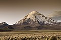
Nevado Sajama ([neˈβaðo saˈxama]; Aymara: Chak Xaña) is an extinct volcano and the highest peak in Bolivia. The mountain is located in Sajama Province, in Oruro Department. It is situated in Sajama National Park and is a composite volcano consisting of a stratovolcano on top of several lava domes. It is not clear when it erupted last but it may have been during the Pleistocene or Holocene.
The mountain is covered by an ice cap, and Polylepis tarapacana trees occur up to 5,000 metres (16,000 ft) elevation. (Full article...) -
Huascarán (Spanish pronunciation: [waskaˈɾan]) (Quechua: Waskaran), Nevado Huascarán or Mataraju is a mountain located in Yungay Province, Department of Ancash, Peru. It is situated in the Cordillera Blanca range of the western Andes. The southern summit of Huascarán (Huascarán Sur), which reaches 6,768 metres (22,205 ft), is the highest point in Peru, the northern Andes (north of Lake Titicaca), and in all of the earth's Tropics. Huascarán is the 4th highest mountain in South America after Aconcagua, Ojos del Salado, and Monte Pissis. Huascarán is ranked 25th by topographic isolation. (Full article...) -

Lake Junin (IPA: [xuˈnin]; Spanish Lago Junín, named after the nearby town of Junin) or Chinchaycocha (possibly from Quechua chincha, chinchay north, northern, chinchay ocelot, qucha lake, lagoon, "northern lake" or "ocelot lake") is the largest lake entirely within Peruvian territory. Even though Lake Titicaca has a much larger area, its eastern half is located on Bolivian territory. Lake Junin is an important birdwatching destination in the country. (Full article...) -
Aconcagua (Spanish pronunciation: [akoŋˈkaɣwa]) is a mountain in the Principal Cordillera of the Andes mountain range, in Mendoza Province, Argentina. It is the highest mountain in the Americas, the highest outside Asia, and the highest in both the Western Hemisphere and the Southern Hemisphere with a summit elevation of 6,961 metres (22,838 ft). It lies 112 kilometres (70 miles) northwest of the provincial capital, the city of Mendoza, about five kilometres (three miles) from San Juan Province, and 15 km (9 mi) from Argentina's border with Chile. The mountain is one of the Seven Summits of the seven continents.
Aconcagua is bounded by the Valle de las Vacas to the north and east and the Valle de los Horcones Inferior to the west and south. The mountain and its surroundings are part of the Aconcagua Provincial Park. The mountain has a number of glaciers. The largest glacier is the Ventisquero Horcones Inferior at about 10 km (6 mi) long, which descends from the south face to about 3,600 m (11,800 ft) in elevation near the Confluencia camp.
Two other large glacier systems are the Ventisquero de las Vacas Sur and Glaciar Este/Ventisquero Relinchos system at about 5 km (3 mi) long. The best known is the northeastern or Polish Glacier, as it is a common route of ascent. (Full article...) -

Pico Mucuñuque is a mountain in the Andes of Venezuela. It has a height of 4,609 metres. (Full article...) -
Telmatobius macrostomus, also known as the Lake Junin (giant) frog or Andes smooth frog, is a very large and endangered species of frog in the family Telmatobiidae. This completely aquatic frog is endemic to lakes and associated waters at altitudes of 4,000–4,600 m (13,100–15,100 ft) in the Andes of Junín and Pasco in central Peru. It has been introduced to slow-moving parts of the upper Mantaro River, although it is unclear if this population still persists.
Together with the closely related Amable Maria frog (T. brachydactylus), it is sometimes placed in the genus Batrachophrynus. (Full article...) -
The Cordillera Paine is a mountain group in Torres del Paine National Park in Chilean Patagonia. The cordillera is located 280 km (170 mi) north of Punta Arenas, and about 1,960 km (1,220 mi) south of the Chilean capital Santiago. It belongs to the Commune of Torres del Paine in Última Esperanza Province of Magallanes and Antártica Chilena Region. No accurate surveys have been published, and published elevations have been claimed to be seriously inflated, so most of the elevations given on this page are approximate. Paine means "blue" in the native Tehuelche (Aonikenk) language and is pronounced PIE-nay. (Full article...)


.jpg)


-2.JPG)


.jpg)


Did you know...
- ... that the 1930s Polish Andean expeditions have been credited with several first ascents and the tracing of a new route to the summit of Aconcagua, the Andes' highest peak?
Need help?
Do you have a question about Andes that you can't find the answer to?
Consider asking it at the Wikipedia reference desk.
Selected images
-

-

-
 Central Andes (from Andes)
 -

-
-

-
 Huayna Potosí, Bolivia (from Andes)
 -

-
 Pico Humboldt at sunset (from Andes)
 -

-
 Irrigating land in the Peruvian Andes (from Andes)
 -

-
 Nevado del Huila, Colombia (from Andes)
 -
 Aerial view of Valle Carbajal in the Tierra del Fuego. The Andes range is about 200 km (124 mi) wide throughout its length, except in the Bolivian flexure where it is about 640 kilometres (398 mi) wide. (from Andes)
 -
 Laguna de Sonso tropical dry forest in Northern Andes (from Andes)
 -
 Peruvian farmers sowing maize and beans (from Andes)
 -

-
 View of Cuernos del Paine in Torres del Paine National Park, Chile (from Andes)
 -

-
 A male Andean cock-of-the-rock, a species found in humid Andean forests and the national bird of Peru (from Andes)
 -
 Frederic Edwin Church, Heart of the Andes, 1859. (from Andes)
 -
 Bolivian Andes (from Andes)
 -
 Parinacota, Bolivia/Chile (from Andes)
 -


.jpg)

.jpg)
%E2%80%93Valle_Carbajal_01.jpg)


Subcategories

- Select [►] to view subcategories
Subtopics
Associated Wikimedia
The following Wikimedia Foundation sister projects provide more on this subject:
-
 Commons
Free media repository -
 Wikibooks
Free textbooks and manuals -
 Wikidata
Free knowledge base -
 Wikinews
Free-content news -
 Wikiquote
Collection of quotations -
 Wikisource
Free-content library -
 Wikiversity
Free learning tools -
 Wiktionary
Dictionary and thesaurus
-->