
User:Glossic-hapludalf/soil morphology sandbox

Soil morphology is the branch of soil science dedicated to the technical description of soil,[1] particularly physical properties including texture, color, structure, and consistence. Morphological evaluations of soil are typically performed in the field on a soil profile containing multiple horizons.[2]
Along with soil formation and soil classification, soil morphology is considered part of pedology, one of the central disciplines of soil science.[3]
Background[edit]
Since the origin of agriculture, humans have understood that soils contain different properties which affect their ability to grow crops.[4] However, soil science did not become its own scientific discipline until the 19th century, and even then early soil scientists were broadly grouped as either "agro-chemists" or "agro-geologists" due to the enduring strong ties of soil to agriculture. These agro-geologists examined soils in natural settings and were the first to scientifically study soil morphology.[5]
A team of Russian early soil scientists led by V.V. Dokuchaev observed soil profiles with similar horizons in areas with similar climate and vegetation, despite being hundreds of kilometers apart.[6] Dokuchaev's work, along with later contributions from K.D. Glinka, C.F. Marbut, and Hans Jenny, established soils as independent, natural bodies with unique properties caused by their equally unique combinations of climate, biological activity, relief, parent material, and time. Soil properties had previously been inferred from geological or environmental conditions alone, but with this new understanding, soil morphological properties were now used to evaluate the integrated influence of these factors.[7]
Soil morphology became the basis for understanding observations, experiments, behavior, and practical uses of different soils.[7] To standardize morphological descriptions, official guidelines and handbooks for describing soil were first published in the 1930s by Charles Kellogg and the United States Department of Agriculture-Soil Conservation Service for the United States and by G.R. Clarke for the United Kingdom. Many other countries and national soil survey organizations have since developed their own guidelines.[8]
Properties and Procedure[edit]
Observations of soil morphology are typically performed in the field on soil profiles exposed by excavating a pit or extracting a core with a push tube (handheld or hydraulic) or auger.[9] A soil profile is one face of a pedon, or an imaginary three-dimensional unit of soil that would display the full range of properties characteristic of a particular soil. Pedons generally occupy between 1 to 10 m2 of surface land area and are the fundamental unit of field-based soil study.[10]
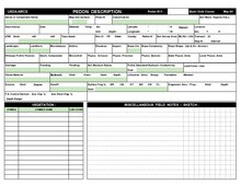
Many soil scientists in the United States document soil morphological descriptions using the standard Pedon Description field sheet published by the USDA-NRCS. In addition to location, landscape, vegetation, topographic, and other site information, soil morphology descriptions generally include the following properties:
Horizonation[edit]
[Condense content currently in article, ensure to cover master and subordinate horizons, depth, boundary distinctness and topography, change in PM]
Soil profiles contain multiple layers, known as horizons, that are generally parallel to the soil surface. These horizons are distinguishable from adjacent layers by their changes in morphological properties as the soil naturally forms. The same soil horizons may be named and labeled differently in various soil classification systems around the world, though most systems contain the following:

- Numerical prefix: indicates a lithologic discontinuity or change in parent material
- Capital letter: represents the master horizon, such as O, A, E, B, C, R, and others. Multiple capital letters may be used to describe transition horizons, which are layers with properties of multiple master horizons (such as AB or A/B horizons).
- Lowercase letter: horizon suffix or subordinate distinction, which add details of soil formation. Multiple suffixes may be used in combination, and some master horizons (including O, B, and L) must be described with a suffix.
- Numerical suffix: indicates subdivisions within a larger horizon. If there are layers distinct enough to be separate horizons, but similar enough to receive the same master and suffix letters, sequential numbers are added to the end of the designation to distinguish the horizons (such as A, Bt1, Bt2, Bt3, C).[7]
transition, boundary, topography
Color[edit]
Soil color is quantitatively described using the Munsell color system, which was developed in the early 20th century by Albert Munsell. Munsell was a painter and the system covers the entire range of colors, though the specially adapted Munsell soil color books commonly used in field description only include the most relevant colors for soil.[11]
The Munsell color system includes the following three components:
- Hue: indicates the dominant spectral (i.e., rainbow) color, which in soil is generally yellow and/or red. Each page of the Munsell soil color book displays a different hue. Examples include 10YR, 5YR, and 2.5Y.
- Value: indicates lightness or darkness. Value increases from the bottom of each page to the top, with lower numbers representing darker color. Color with a value of 0 would be black.
- Chroma: indicates intensity or brightness. Chroma increases from left to right on each page, with higher numbers representing more vivid or saturated color. Color with a chroma of 0 would be neutral gray.
Colors in soil can be quite diverse and result from organic matter content, mineralogy, and the presence and oxidation states of iron and manganese oxides. Organic-rich soils tend to be dark brown or even black due to organic matter accumulating on the mineral particles. Well-drained and highly weathered soils may be bright red or brown from oxidized iron, while reduced iron can impart gray or blue colors and indicate poor drainage. When soil is saturated for prolonged periods, oxygen availability is limited and iron may become a biological electron acceptor. Reduced iron is more soluble than oxidized iron and is easily leached from particle coatings, which exposes bare, light-colored silicate minerals and results in iron depletions. When iron reduction and/or depletion makes gray the dominant matrix color, the soil is said to be gleyed.[10]
Soil color is also moisture dependent, specifically the color value. It is important to note the moisture status as "moist" when adding water does not change the soil color, or as "dry" when the soil is air dry.[12] The standard moisture status for describing soil in the field varies regionally; humid areas generally use the moist state while arid ones use the dry state. In detailed descriptions, both the moist and dry colors should be recorded.[7]
Texture[edit]
[Condense content currently in article, ensure to cover sand/silt/clay, coarse fragments, methods of analysis]
Structure[edit]

Soil particles naturally aggregate together into larger units or shapes referred to as "peds". Peds have planes of weakness between them are generally identified by probing exposed soil profiles with a knife to pry out and gently break apart volumes of soil.[12]
Morphological descriptions of soil structure contain assessments of shape, size, and grade. Structure shapes include granular, platy, blocky, prismatic, columnar, and others, including the "structureless" shapes of massive and single-grained. Size is classified as one of six categories ranging from "very fine" to "extremely coarse," with different size limits for the various shapes and measurements taken on the smallest ped dimension. Grade indicates the distinctness of peds, or how easily distinguishable they are from each other, and is described with the classes "weak", "moderate", and "strong."[7]
Structure is often best evaluated while the soil is relatively dry, as peds may swell with moisture, press together and reduce the definition between each ped.[10]
Consistence[edit]
[Not currently in article-- summarize as Degree of cohesion and adhesion or resistance to deformation and rupture. Stickiness, plasticity, toughness, rupture resistance; loose, friable, firm, rigid etc]
Redoximorphic Features[edit]
[Not currently in article-- summarize mottles and Fe/Mn concentrations and depletions, implications for land use]
Concentrations[edit]
[Not currently in article-- summarize as Identifiable features that naturally form in the soil. Includes masses, which are non-cemented concentrations that cannot be removed as a discrete unit. Could include calcium carbonate, fine crystals of gypsum or other soluble salts, or iron and manganese oxides. Also includes plinthite, nodules or concretions, crystals, and biological concentrations such as wormcasts.
Ped and Void Surface Features[edit]
Clay films, slickensides
Roots and Pores[edit]
Root size and quantity, pore quantity, size, shape, continuity
"Minimum Data Set"[edit]
The purpose, logistics, and methods of soil description, along with the soil itself, influence the specific properties necessary to adequately describe any given soil. However, certain morphological properties are so essential for interpreting soil that they should always be recorded. These properties represent the "minimum data set" for soil description and include the location, horizons, horizon depth, horizon boundaries, color, redoximorphic features, texture, structure, and consistence.[9]
Micromorphology[edit]
Keep content currently in article
[Miscellaneous changes][edit]
Remove Formation section, since that belongs in Pedogenesis topic and not morphology (proposed in article Talk page)
- ^ Owens, P. R.; Rutledge, E. M. (2005-01-01), Hillel, Daniel (ed.), "MORPHOLOGY", Encyclopedia of Soils in the Environment, Oxford: Elsevier, pp. 511–520, doi:10.1016/b0-12-348530-4/00002-3, ISBN 978-0-12-348530-4, retrieved 2023-02-26
- ^ Buol, Stanley W.; Southard, Randall J.; Graham, Robert A.; McDaniel, Paul A. (2003). Soil genesis and classification (5th ed.). Ames, Iowa: Iowa State Press. ISBN 0-8138-2873-2. OCLC 50034831.
- ^ Arnold, Richard W. (2016-01-01), Sparks, Donald L. (ed.), "Perspectives About the National Cooperative Soil Survey", Advances in Agronomy, Advances in Agronomy, vol. 136, Academic Press, pp. 1–26, doi:10.1016/bs.agron.2015.11.003, retrieved 2023-02-26
- ^ Brevik, Eric C.; Hartemink, Alfred E. (2010-10-15). "Early soil knowledge and the birth and development of soil science". CATENA. 83 (1): 23–33. doi:10.1016/j.catena.2010.06.011. ISSN 0341-8162.
- ^ Hartemink, Alfred E. (2009-11-15). "The depiction of soil profiles since the late 1700s". CATENA. 79 (2): 113–127. doi:10.1016/j.catena.2009.06.002. ISSN 0341-8162.
- ^ Brady, Nyle C. (2014). Elements of the nature and properties of soils. Ray R. Weil (4th ed.). Harlow, Essex. p. 54. ISBN 978-1-292-03929-9. OCLC 880670180.
{{cite book}}: CS1 maint: location missing publisher (link) - ^ a b c d e Soil Science Division Staff. 2017. Soil and Soil Survey. In C. Ditzler, K. Scheffe, and H.C. Monger (eds.). Soil survey manual, USDA Handbook 18. Government Printing Office, Washington, D.C.
- ^ Hartemink, Alfred E. (2009-11-15). "The depiction of soil profiles since the late 1700s". CATENA. 79 (2): 113–127. doi:10.1016/j.catena.2009.06.002. ISSN 0341-8162.
- ^ a b Schonenberger, P.J., D.A. Wysocki, E.C. Benham, and Soil Survey Staff. 2012. Field book for describing and sampling soils, Version 3.0. Natural Resources Conservation Service, National Soil Survey Center, Lincoln, NE, USA. https://www.nrcs.usda.gov/sites/default/files/2022-09/field-book.pdf
- ^ a b c Brady, Nyle C.; Weil, Ray R. (2010). Elements of the nature and properties of soils (3rd ed.). Upper Saddle River, N.J.: Prentice Hall. ISBN 978-0-13-501433-2. OCLC 276340542.
- ^ Owens, P. R.; Rutledge, E. M. (2005). Encyclopedia of soils in the environment. Daniel Hillel, Jerry L. Hatfield (1st ed.). Oxford, UK: Elsevier/Academic Press. p. 514. ISBN 0-12-348530-4. OCLC 52486575.
- ^ a b Buol, S. W. (2011). Soil genesis and classification. R. J. Southard, R. C. Graham, P. A. McDaniel (6th ed.). Chichester, West Sussex. ISBN 978-0-470-96062-2. OCLC 747546196.
{{cite book}}: CS1 maint: location missing publisher (link)