
User:Happybluemo/sandbox

| Forbes Creek | |
|---|---|
 Vista aérea de Kirkland con la cuenca hidrográfica de Forbes Creek resaltada. El norte está arriba. El centro de Kirkland en Moss Bay está un poco a la izquierda del centro, Juanita Bay está a la izquierda arriba. Forbes Lake está al nortoeste del distribuidor vial de I-405. | |
 Mapa mostrando el curso de Forbes Creek, pantanos, y el alcance aproximado de su área de drenaje. | |
 Ubicación de la boca de Forbes Creek en Washington.  Happybluemo/sandbox (the United States) | |
| Location | |
| País | United States |
| Estado | Washington |
| Región | King County |
| Ciudad | Kirkland, Washington |
| Physical characteristics | |
| Source | |
| • coordinates | 47°40′48.5″N 122°10′4″W / 47.680139°N 122.16778°W |
| • elevation | 360 ft (110 m) |
| Mouth | Juanita Bay Park |
• location | Lake Washington |
• coordinates | 47°41′56″N 122°12′39″W / 47.69889°N 122.21083°W |
• elevation | 16 ft (4.9 m) |
| Length | 2.5 mi (4.0 km) |
| Basin size | 6.6 sq mi (17 km2) |
Forbes Creek es un arroyo pequeño y poco inclinado totalmente adentro de la ciudad de Kirkland, Washington.[1] Desde su naciente en la morrena de Rose Hill hasta su salida en Juanita Bay es alrededor de 2 miles (3.2 km) en línea recta. El alcance norteño de su cuenca es una línea casi este-oeste a NE 116th Street; el límite oriental está en a la cresta de Rose Hill, aproximadamente norte-sur a 132nd Avenue NE. El alcance sureño es irregular tendiendo aproximadamente desde el punto más alto de Kirkland en la esquina norteste de Bridle Trails State Park (535 ft (163 m), 47°39′26″N 122°10′21″W / 47.65722°N 122.17250°W[2]) a través de South Rose Hill Park, hasta Lake Washington a unos 16 feet (4.9 m) sobre el nivel del mar.[3]
Dos ramales principales del arroyo levantan por Rose Hill entre NE 70th Street y NE 85th Street y luego se van del sur al norte en Rose Hill. Uno de ellos se levanta en la vicinidad de Lake Washington High School y se va al norte por Costco #008 hacia Forbes Lake. El otro se levanta un poco al este en la vicinidad de Rose Hill Elementary School luego a través de North Rose Hill Woodlands Park. Los dos se juntan al norte del lago y luego van al oeste a través de un conducto de dos metros debajo de Interstate 405 acerca de NE 100th Street,[4] debajo del Cross Kirkland Corridor, hasta el Valle Forbes Creek y Juanita Bay Wetlands Park. El arroyo finalmente desemboca hasta Lake Washington a Juanita Bay, menos de un kilómetro de la boca de Juanita Creek que desemboca hasta la misma bahía.
Cuenca y humedales[edit]
La cuenca de Forbes Creek es una 1,837-acre (743 ha) cuenca hidrográfica cubriendo un cuarto de la área total de la tierra de Kirkland.[5] Forbes Creek desemboca hasta Lake Washington en el barrio de Juanita. Veintidós humedales existen en la cuenca, constituyendo el número y área más grande de humedales de cualquier arroyo en Kirkland (no hay ningún río).[6]
Especies de planta[edit]
Especies invasoras de planta incluyendo la zarza himalaya están presentes en las cuencas de Kirkland.[7] Viburnum opulus introducido (posiblemente cultivado) crece sobre Forbes Lake.
-
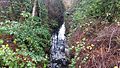 La zarza himalaya invasora y acebo en el cauce del arroyo mezclados con sotobosque de salal y helecho de espada nativos debajo de alisos y cedros.
 -
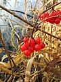 Viburnum opulus en la orilla de lago.
 -
 Árbol en Forbes Lake Park mordido por castores.
 -
 Castor en los nenúfares de la bahía.
 -
 Observadores de aves en la orilla de Lake Washington en Juanita Bay Park.


.jpg)

Ice age creation[edit]
The landforms and hydrology of the Eastside, including Forbes Creek, are due to the ice age glaciation. Forbes Creek watershed displays every aspect of typical Eastside moraines described by Harvey Manning and Ira Spring, as an "'unorganized' geography on glacial moraine with bogs and creeks reaching lake level".[8]
Forbes Lake[edit]
Forbes Lake (47°41′09″N 122°10′47″W / 47.68583°N 122.17972°W) is a 7-acre (2.8 ha), 30-foot (9.1 m) deep kettle lake[9][10] at elevation 246 feet (75 m) above sea level.[11] The city is developing areas around the lake under a Forbes Lake Trail and Park Improvements Project of 16 acres (6.5 ha). Wildlife in the area includes frogs and turtles in the lake; raptor bird species including hawks and bald eagles which use the tall trees around the lake; aquatic birds using the lake and surrounding wetlands include ducks and great blue herons; and mammals such as beaver, deer, and coyotes.[12]

Naming[edit]

Forbes Lake is named for the Forbes family of settlers. Dorr Forbes, a Civil War veteran with 33rd Illinois Volunteer Infantry Regiment, from La Moille, Illinois,[13] and his wife Eliza had a farm on the lake in 1877, probably growing cranberries. The farming was ruined by beavers and the family sold the land which later became the steel mill site (see below). The family also had a shingle mill on Juanita Creek.[14] and a home on Juanita Bay, built in the 1880s in Madison Park, Seattle[15] and moved across the lake by barge or boat. It was rebuilt in 1905.[16]
Steel mill[edit]
Forbes Lake was the site of the Kirkland Steel Mill, built by the city's founder Peter Kirk, but it never produced any steel. The enterprise folded in the Panic of 1893.[17]
Juanita Bay Park[edit]

The wetlands where Forbes Creek enters Lake Washington are Juanita Bay Park, Kirkland's largest city park at 110 acres (45 ha).[18][19] A Duwamish village was located there prior to 1830, and wapato tubers harvested in the wetlands.[15][20] Inhabitants include large numbers of year-round and overwintering birds, including osprey, owls, bald eagles, herons and woodpeckers. As many as 1,600 birds have been counted at once in the park.[21] The park also is home to many mammal species including beaver, muskrat, nutria, raccoon, river otter, weasel, and coyote.[22]
The Forbes Creek wetlands are noted as prime urban birdwatching areas by The National Geographic Society, Reader's Digest, and many Pacific Northwest guidebooks.[23][24][25]
The Juanita Bridge, built in 1891 and rebuilt in 1932, carried Market Street wagon traffic, later automobile traffic, across the wetland. It was converted to pedestrian-only use in 1974 when a new bridge was built slightly to the east.[26][27]
References[edit]
- ^ Parametrix 2005, p. 19.
- ^ "Kirkland high point". Peakbagger.com. Retrieved December 15, 2016.
- ^ The Watershed Company 1998.
- ^ I-405 Kirkland Nickel Project – Stage 1 Construction Environmental Improvements (Forbes Creek) (PDF), Washington State Department of Transportation, March 2006
- ^ Parametrix 2005, p. 20.
- ^ The Watershed Company 1998, p. 51.
- ^ The Watershed Company 1998, pp. 11, 21, 41, etc..
- ^ Manning, Manning & Spring 2002.
- ^ "Forbes Lake vital statistics", Water and land services small lakes database, King County, Washington, retrieved December 15, 2016
- ^ "A Gift from the Ice Age" interpretive sign, City of Kirkland, 120th Avenue public access on southwest corner of lake.
- ^ U.S. Geological Survey Geographic Names Information System: Forbes Lake
- ^ Worthy and Associates 2009, p. 4.
- ^ "Detail Report: Forbes, Dorr PVT, 33 IL US INF Company E", Illinois Civil War database, Illinois Secretary of State, record 84767, retrieved December 24, 2016
- ^ Juanita "remember when" map 1900-1918, derived from records and oral history, at Kirkland branch map file, King County Library System
- ^ a b King County Historic Preservation 2002.
- ^ Matthew McCauley, Juanita's First Family, Kirkland Heritage Society
- ^ Ely 1975.
- ^ Manning 1995, p. 61.
- ^ Park guide, City of Kirkland
- ^ Cathy McDonald (January 19, 2011), "Juanita Bay Park is a popular winter walk, well-interpreted", The Seattle Times
- ^ Manning, Manning & Spring 2002, p. 76.
- ^ City of Kirkland 2011.
- ^ Alderfer 2006, p. 12.
- ^ Dolezal 2007, p. 44.
- ^ Stevens & Weber 2016, p. 73.
- ^ Kirkland Historical Tour, Eastside Heritage Center, 2006
- ^ Juanita Bridge, Lake Washington, Museum of History and Industry, image 1998.10.39 – via University of Washington digital collections
Bibliography[edit]
- Alderfer, Jonathan (2006), National Geographic Field Guide to Birds: Washington & Oregon, National Geographic Books, ISBN 9780792253136
- Dolezal, Robert J. (2007), Where the Birds Are: A Travel Guide to Over 1,000 Parks, Preserves, and Sanctuaries, Reader's Digest Association, ISBN 9780762108602
- Ely, Arline (1975), Our Foundering Fathers (PDF), Kirkland Public Library
- Juanita Bay Park: An Urban Wildlife Habitat (PDF), City of Kirkland, February 1, 2011
- King County Historic Preservation Program (c. 2002), Juanita Beach Park History (PDF) – via City of Kirkland
- Manning, Harvey; Manning, Penny; Spring, Ira (2002), "The Eastern Moraines: Overlake", Best Winter Walks and Hikes: Puget Sound, The Mountaineers Books, pp. 59–60, ISBN 9780898868227
- Manning, Harvey (1995), Walks and Hikes in the Foothills and Lowlands Around Puget Sound, Mountaineers Books, ISBN 9780898864311
- Parametrix (2005), "Existing Conditions and Problems in Kirkland's Watersheds", Surface Water Master Plan, City of Kirkland, archived from the original on March 7, 2015 (Chapter 3)
- Stevens, Bryce; Weber, Andrew (2016), 60 Hikes Within 60 Miles: Seattle: Including Bellevue, Everett, and Tacoma, Menasha Ridge Press, ISBN 9781634040181
- The Watershed Company (July 1998), "Forbes Creek Basin", Kirkland's Streams, Wetlands and Wildlife Study, pp. 48–58, archived from the original on March 28, 2015 – via City of Kirkland
- Worthy and Associates (March 2009), Forbes Lake Trail and Park Improvements Plan (PDF) – via City of Kirkland
External links[edit]
- Forbes Lake Trail and Park Improvements Project at Kirkland Parks
- Stream report at King County Department of Natural Resources
Category:Geography of Kirkland, Washington Category:Rivers of King County, Washington Category:Watersheds of the West Coast (U.S.)