User:Mayawagon/sandbox/
< User:Mayawagon | sandbox
| Cotopaxi | |
|---|---|
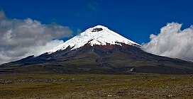
 Cotopaxi seen from the high plain (3.700 + m.) of Cotopaxi National Park | |
| Highest point | |
| Elevation | 5,897 m (19,347 ft) |
| Prominence | 2,403 m (7,884 ft)[1] |
| Listing | Ultra |
| Coordinates | 0°40′50″S 78°26′16″W / 0.68056°S 78.43778°W |
| Geography | |
| Location | Pichincha / Cotopaxi, Ecuador |
| Parent range | Andes |
| Topo map | 234234234 |
| Geology | |
| Mountain type | Stratovolcano, Historical |
| Volcanic arc/belt | North Volcanic Zone |
| Last eruption | August 2015 to January 2016[2] |
| Climbing | |
| First ascent | 28 November 1872 by Wilhelm Reiss and Ángel Escobar |
| Easiest route | North side: Glacier/Snow Climb (Grade PD-) |
