
User:MaynardClark/Charlesbank
| It is approximately 9:37 AM in this user's locale. ( to update.) |
The Charlesbank Cooperative Corporation is a cooperatively-owned corporation which houses in its 24-story high-rise residence about 300 persons in 276 habitable units. The building was erected from 1960-1963 and first opened in late 1963 for residents, while construction continued on the building. The completion of occupancy was in 1964, which is marked as the building's official opening date. The corporation is administered by a democratically-elected Board, which delegates management of the building to a contracted management company, Maloney Properties of Wellesley. It is one of three residential high-rise buildings in the triangular area of Mission Hill to the east of the Longwood Medical and Academic Area, where Harvard teaching hospitals, the Harvard School of Public Health, the Harvard Medical School, and the Harvard School of Dental Medicine are located. Charlesbank is situated in the narrow, northerly tip, across the street from MassArt's Smith Hall student residence. CityView at Longwood, site of Mission Fitness Boston's 24/7 health club, is at 75 St. Alphonsus Street, and The Longwood apartments[1], which also houses a gym ("state-of-the-art fitness center") and the Mission Hill branch of the US Post Office, is at 1575 Tremont Street in Brigham Circle. Charlesbank's large water-seeking willow tree reputedly has roots reaching under Huntington Avenue and the Huntington Avenue Green Line E-train route and into the Longwood Medical and Academic Area, where Harvard Medical School's Department of Global Health and Social Medicine is located.


Brief History of Charlesbank Apartments, Inc.[edit]
Charlesbank Apartments, Inc., was the nonprofit corporation owning the 24-story residential high-rise known as Charlesbank, whose 'out-of-territory' name may be derived from a previous residential corporation in Boston's West End. The architects of the building were Hugh Stubbins and Associates of Cambridge, who also had designed Harvard's Countway Medical Library (opened in 1965), the Loeb Drama Center (opened in 1960), and the Pusey Library (opened in 1976), as well as the Federal Reserve Bank of Boston (opened in 1978) and the Animal Rescue League of Boston (opened in 1956).[1][2]
A historical research project was initiated by interested residents of Charlesbank on the occasion of its 50th anniversary in 2014, which coincides with the 20th anniversary of the creation of the Charlesbank Cooperative Corporation, which owns the Charlesbank high-rise building, and the 20th anniversary of their relationship with Maloney Properties, which manages many of the concerns related to the Charlesbank high-rise building.
Briefly, hopes had been expressed that Leonard Nimoy's recent interest in Boston's West End, where he was reared, would enable ongoing research into the historical association between Boston's Mission Hill and Boston's West End, both of which have been profoundly impacted by the expansion of Harvard's robust and world class teaching hospitals.
Boston's current Mayor Martin Walsh had questioned the existence of the Boston Redevelopment Authority (BRA) and, during his mayoral campaign, had suggested abolishing the BRA. Instead, what was the BRA has emerged as the Boston Planning and Development Agency (BPDA).
Prehistory of Charlesbank Apartments
Charlesbank Homes, Inc., was a multi-unit private residence in Boston's West End, near the Peabody Playhouse. Leonard Nimoy mentioned it to his son Adam in "Leonard Nimoy's Boston" at the 05:08 point in the 28+-minute video, now found on YouTube.
Under the renewal plan to create a "New Boston" under the John B. Hynes administration, when the Boston Redevelopment Authority (BRA) was formed, Boston's West End was leveled, residential and other buildings were demolished, and residents were displaced.
The redevelopment of the West End was officially announced on April 11, 1953. Mayor Hynes and the BRA stated that the project would be beneficial to the neighborhood. The West End's narrow streets were a fire hazard and many of the buildings were not up to code, with approximately 80% of them substandard or marginal.[3] Tenants were assured that affordable housing would be found for them, and many were led to believe that they would be able to move back into the West End after the project was complete.
The plan involved completely leveling a 46-acre (190,000 m2) portion of the West End, displacing 2,700 families to make way for 5 residential high rise complexes that would contain only 477 apartments.[4] The new development was aimed towards upper middle class residents: most of those displaced would not be able to afford to return.
In October 1957, the BRA held a hearing on the new project. At least 200 West End residents attended and the consensus was overwhelmingly opposed to the plan. The Save the West End committee was formed with the support of Joseph Lee to organize protests against the new development. Most residents believed that the project would not be realized, and so did not act until it was too late.[5] Residents received their eviction letters on April 25, 1958. The BRA used the Housing Act of 1949 to raze the West End to the ground. Working-class families were displaced, and superblocks replaced the original street layout. The result was a neighborhood consisting of residential high rises, shopping centers and parking lots.
It is believed that, in order to house some of the displaced West End residents, two or three high-rise apartment buildings were constructed in a triangular area bordered by St. Alphonsus Street to the east, Longwood Avenue to the north, Huntington Avenue to the west, and Tremont Street to the south. An additional special effort was made to affordably house unmarried women who had come to Boston seeking employment, but who traditionally had been paid low wages. Construction of the Countway Medical Library replaced the dormitory for student nurses at the Peter Bent Brigham Hospital, displacing them, also.[6] Ginn of the Ginn Publishing Company was a major investor in the construction at the corner of St. Alphonsus Street, Longwood Avenue, and Huntington Avenue. Digging began around 1960 or 1961, and building construction commenced around 1961, the year Stubbins was named architect for the Countway Medical Library. The building was opened over the one-year period of 1963-1964, as the units progressively filled.
Harvard University's Graduate School of Design houses the indexed archival boxed materials related to the building's construction and its financing, including architectural records and financial agreements.
History of the Neighborhood[edit]
Mission Hill is a 3/4 square mile [7] neighborhood of Boston, with the population of approximately 18,000 people.
The neighborhood is roughly bounded by Columbus Avenue and the Boston neighborhood of Roxbury to the east, Longwood Avenue to the northeast and the Olmsted designed Riverway/Jamaicaway and the town of Brookline to the west. The Historic District is roughly bounded by Smith Street, Worthington Street, Tremont Street (to the south), and Huntington Avenue (to the west). It is immediately north of the Boston neighborhood of Jamaica Plain. It is served by the MBTA Green Line E Branch and the Orange Line and is within walking distance of the Museum of Fine Arts. "The Hill" overlaps with about half of the Longwood Medical and Academic Area, home to 21 health care, research, education institutions and are responsible for the largest employment area in the City of Boston outside of downtown. Due to these adjacencies, the neighborhood is often struggling with institutional growth taking residential buildings and occupying storefront commercial space. But recent years have seen new retail stores, restaurants, and residential development giving the neighborhood a stronger political voice and identity, as some of the educational institutions have made commitments to house all or most of their undergraduate students in newly-erected campus housing, including high-rise dormitories.
Mission Hill is an architectural landmark district with a combination of freestanding houses built by early wealthy landowners, blocks of traditional brick rowhouses, and many Triple decker. Many are condominiums, but there are also several two-family and some single-family homes.
The neighborhood was named in March 2008 as one of 25 "Best Zip Codes in Massachusetts" by the Boston Globe, citing increased value in single-family homes, plentiful restaurants and shopping, a marked racial diversity and that 65% of residents walk, bike or take transit to work.[8]
Until the American Revolution, Mission Hill supported large country estates of wealthy Boston families. Much of the area was an orchard farm, originally owned by the Parker family in the 18th century. Peter Parker married Sarah Ruggles, whose family owned large areas of land including most of what became known as Parker Hill (later renamed Mission Hill). His life ended when a barrel of his own cider fell on him. (Much of this story is outlined in "The History of Peter Parker and Sarah Ruggles", a book by John William Linzee, published in 1913.)
The orchard continued for some time thereafter, but gradually pieces of the land were sold and developed. Boston’s reservoir was once located at the top of the hill. Many of the older apple trees along Fisher Avenue and in an undeveloped area of the playground are probably descendants of the Parker family’s original trees. The lower portion of the eastern hill was a puddingstone quarry with large swaths owned by merchants Franklin G. Dexter, Warren Fisher, and Fredrick Ames.

Maps of the area indicate Mission Hill development began before the Fenway and Longwood Medical Area. Huntington Avenue, now one of the main connections to the rest of Boston, once stopped at the intersection of Parker Street, near the present-day site of the Museum of Fine Arts. Up until that time, Mission Hill was connected via Parker Street (a man-made raised passage between the Stony Brook and the Muddy River - both which formed a tidal flat into the Charles River) all the way to Boylston Street in the Back Bay. Part of what was once Parker Street is now called Hemenway Street. The once main intersection of Parker Street and Huntington Avenue has been traffic-engineered, cutting the straight-line road in two and forcing traffic to first turn onto Forsyth Way to make the connection. Many other streets leading into Mission Hill were also realigned and/or renamed at Huntington Avenue (including Longwood Avenue/McGreevey Way, Smith/Shattuck Street, Vancouver Street, and Palace Road/Worthington Street), limiting both pedestrian and vehicular access.
After the 1880s and the re-routing of the Muddy River by Frederick Law Olmsted, Huntington Avenue was joined from Parker Street to Brigham Circle, creating the Triangle District. (Maps from the time indicate that Huntington Avenue from Brigham Circle to the Brookline line was named Tremont Street.)

Development began in earnest in the mid-19th century. In 1870, the Redemptorist Fathers built a humble wooden mission church that was replaced by an impressive Roxbury puddingstone structure in 1876. In 1910, dual-spires were added that now dominate the skyline. The church was elevated to basilica in 1954 by Pope Pius XII and is one of only 43 in the United States. Officially named Our Lady of Perpetual Help after the icon of the same name, it is uniformly referred to as "Mission Church", even by its own parishioners. Due to a sloping foundation of this landmark, the west cross tops its tower at 215 feet (66 m); the other spire is two feet shorter. The length of the church is also 215 feet (66 m), presenting a perfect proportion.
At one time, the Basilica was a campus of buildings; the Queen Anne style Sister's Convent and Grammar School (1888–1889, Henry Burns) and the Romanesque Revival St. Alphonsus Hall (1898, Franz Joseph Untersee) administered by the parish. The church closed the high school in 1992, but a Parochial elementary school still remains. The sale of these buildings at 80-100 Smith Street allowed much of the church to be restored. The sold buildings are currently planned for Basilica Court, a 229-unit residential complex, developed by Weston Associates, Inc. The Hall was the club headquarters for the St. Alphonsus Association founded in 1900. It was the preeminent social and athletic Catholic men's organization for nearly 50 years and its 1000 seat theatre held many community, political and theatrical events.
Another example of high religious architecture is the Byzantine-style Annunciation Greek Orthodox Cathedral at 514 Parker Street at the eastern edge of the neighborhood. Referred to as the "mother church" of the Greek Orthodox Church in New England, it is the cathedral of the Diocese of Boston and the seat of its Bishop Methodios. Built between 1892–1927, it is one of the oldest Greek churches in the United States, a Boston landmark, and is listed on the National Register of Historic Places. In 1927 a Greek artist was commissioned to decorate the cathedral with Byzantine iconography. The radiant stained glass windows and large crystal chandeliers also contribute to the visual majesty of the cathedral's interior.
Puddingstone plays a historic role in the area. The large puddingstone quarry that ran between Tremont Street and Allegany Street produced the stone foundations of most of the late 19th century houses in the neighborhood. This locally sourced material made quick construction of working-class housing possible. Some structures around the Tremont Street/Parker Street intersection are made entirely of the material, including 682-688 Parker Street, 2-5 Sewall Street and 1472-74 Tremont Street (1856, David Connery, mason).
Most of the houses in the neighborhood are stone foundations and wood construction. But the Triangle Historic District along Huntington Ave. is stone and brick, and one of only eight such districts in Boston given landmark status by the city. These seventy-one buildings bordered by Huntington Avenue, Tremont Street, and Worthington Street exemplify the development of the neighborhood from the 1870s through the 1910s. Construction of this area was begun in 1871. The Helvetia, a distinctive apartment hotel, was built at 706-708 Huntington Avenue in 1884-1885; a Georgian revival apartment building known as The Esther was built at 683 Huntington/142-148 Smith Street in 1912. Both buildings continue have retail on the ground floor and apartments above. Similar row houses line one side of Delle Avenue a few blocks away from the Triangle District. Taller and larger brick row houses also line Huntington Avenue, Wait Street and South Huntington.
By 1894, the electric streetcar was in operation on Huntington Avenue. Builder-developers began cutting streets through the hillside farmland and building homes for commuters on Parker Hill Avenue, Hillside Street, and Alleghany Street. An excellent example from this era is the Timothy Hoxie House at 135 Hillside Street. A freestanding Italianate villa, it was built in 1854 across from its present location. The Hoxie family left Beacon Hill for pastoral Mission Hill. Houses of this size are rare today. Demand for housing went up and builders turned to building multifamily dwellings, generally constructed on smaller lots.
The carpenter-contractor John Cantwell lived in the Gothic Revival cottage at 139 Hillside Street, and purchased the Hoxie House after Timothy’s death. He moved the house to its present site so that upper Sachem Street could be cut through. Cantwell also developed triple deckers on adjacent lots on Darling and Sachem Streets, and in 1890 subdivided the lot on which the Hoxie House stood and built triple-deckers at 17 and 19 Sachem Street.
By the 1890s, there was a more urban feel to the neighborhood and the hill was covered in triple-deckers. Calumet, Iroquois and other streets with Native American names were built up within ten years into a dense neighborhood of triple deckers in the Queen Anne style. The Queen Anne style is prevalent in Mission Hill because this building boom coincided with the popularity of this style. A restoration of this style of houses along Parker Street is becoming something of a Polychrome Row.

Before 1900, the Georgian Revival New England Baptist Hospital (at the time, the Robert Breck Brigham Hospital) at 125 Parker Hill Ave was one of the few institutions in the neighborhood. Other soon followed, moving from their downtown locations to the Mission Hill/Longwood area for more space and less expensive land (along with the completion of the Emerald Necklace). In 1906, the Harvard Medical School moved into five buildings on Longwood Avenue. Wentworth Institute at 360 Ruggles Street began building in 1911. In 1912, the then Peter Bent Brigham Hospital (now Brigham & Women's) opened on Brigham Circle. In 1914, Children's Hospital also moved to Longwood Avenue. Beth Israel Deaconess was constructed a short time later.[9]
In the late 19th century through the 1970s, the neighborhood was once home to large numbers of families of recent Immigrant descent, mostly Irish, but also Germans, Italians and others. After the 1950s, the combined effects of urban renewal, white flight, and institutional growth caused many to flee the neighborhood. In the early 1960s, the Boston Redevelopment Authority razed several homes in the Triangle District section of the neighborhood to make way for the Whitney Redevelopment Project, which are three high-rise towers along St. Alphonsus Street. They include Charlesbank Apartments (272 unit co-op), Back Bay Manor (270 units), and Franklin Square Apartments (formerly Back Bay Towers - 146 units). This project was one of Boston's earliest redevelopment projects not funded by federal renewal monies.[9] Across the street is Mission Main, one of the nation's oldest public housing developments. The original thirty-eight 3-story brick structures built between 1938 and 1940 were demolished in the mid-1990s and replaced with 535 new apartments with a mix of subsidized and market-rate units.
Industry began in the area as early as the 17th century. The first brewery was established at the foot of Parker Hill in the 1820s. By the 1870s beer production was the main industry in Mission Hill, and many breweries lined the Stony Brook (now a culvert running along the Southwest Corridor). Most of Boston's breweries were once located in Mission Hill, but three periods of Prohibition (1852–1868, 1869–1875 and 1918–1933) and the nation's transition from local breweries to national mass-produced brands took their toll on business. Many of the remaining buildings are now being converted into loft condominia.

Breweries included A.J. Houghton (1870–1918) at 37 Station Street, American Brewing Co. at 251 Heath Street(1891–1934)—now American Brewery Lofts, Union Brewing Co. on Terrace Street (1893–1911), Roxbury Brewing Co. at 31 Heath Street (1896–1899)—the building is now home to the Family Service of Greater Boston, Croft Brewing Co. (1933–1953), Burkhardt Brewing Co. (1850–1918), Alley Brewing Co. at 117 Heath Street (1886–1918) and the Highland Springs Brewery/Reuter & Co. (1867–1918) on Terrace Street—the building is often referred to as The Pickle Factory and is in planning for conversion to housing.

From 1916 through the early 1950s, [Gordon College (Massachusetts)|Gordon College], related to the Ruggles Street Baptist Church formerly on Ruggles Street, was on Evans Way in the Fenway on the edge of Mission Hill. When Gordon moved out of the neighborhood near the Museum of Fine Arts and relocated to Wenham, Massachusetts, Wentworth Institute of Technology bought the land. In the late 1960s, Harvard University, through straws, thus concealing the purchases from the neighborhood, bought the wood frame and brick houses along Francis, Fenwood, St. Alban's, Kempton Streets, and part of Huntington Avenue, and announced plans to demolish the buildings. Most were replaced with the Mission Park residential complex of towers and townhomes in 1978 after neighborhood residents organized the Roxbury Tenants of Harvard Association, which convinced Harvard to rebuild. The tower sits on the site of the House of the Good Shepard, once a large and prominent orphanage. The gates to the complex and the brick wall along Huntington survive from this era.

Also in the 1960s the federal government proposed to extend Interstate 95 into the center of Boston and began buying property and demolishing houses in the Roxbury Crossing section of the neighborhood along the Boston and Providence Rail Road. Roxbury Crossing, once known as Pierpoint Village after the Pierpoint family and their mills (the earliest of which in the 1650s), and has been a stop along the Boston & Providence Railroad since the 1840s, was once a vibrant commercial area with the 749-seat Criterion Theatre, a Woolworths and restaurants.
Though the Interstate project was shelved by the governor in 1971 after freeway revolts, Roxbury Crossing had been leveled. Ten years later saw the creation of the Southwest Corridor, a park system with bike and pedestrian trails that lead into the center of Boston. In November 2007, the MBTA awarded Mission Hill Housing Services rights to develop a new 10-story mixed-use building on what is known to the Boston Redevelopment Authority as "Parcel 25", across from the Roxbury Crossing station.
By the early 1970s, the area was deemed dangerous and most White people and affluent Black people had moved away. The 1989 incident involving Charles Stuart further intensified this view. With property values low, many of the homes were bought by slum lords and converted into rental housing. The inexpensive rents brought many students from nearby colleges and universities, especially MassArt, Northeastern University, Wentworth Institute of Technology, and the School of the Museum of Fine Arts, which has a large studio building in the neighborhood.[10] The Mission Hill Artists Collective now hosts Open Studios[11] in the fall of each year.
As past fears faded by the mid-1990s, the area began to change as homeowners moved into newly converted condominia to take advantage of the fantastic views of the city and proximity to the Longwood Area, the MBTA and downtown Boston.
Today, the neighborhood is briskly gentrifying and diversifying in favor of a mix of new luxury condominia and lofts, triple-deckers converted to condominia, surviving student rental units, newly rebuilt public housing, and strong remnants of long-time residents. Racially, Mission Hill is one of the most diverse in the city, with a balance of white, Asian, Hispanic and African-Americans having little conflict along race lines.
Much of the early history of Mission Hill is covered in a 65 minute documentary film, Mission Hill and the Miracle of Boston, which was directed by Richard Broadman and released in 1978. The film recounts the events that led to the Urban Renewal Program in Boston and its aftermath by showing how these events unfolded in Mission Hill.
Current events include the transformation of Terrace Street into an artist boulevard, with new artists' residences in the planning and approval stages. They will take their place along Diablo[12] glass studio and the Building Materials Co-Op.
History of the Charlesbank Cooperative Corporation[edit]
Construction on Charlesbank Apartments was begun in late 1961[13][14] and opened in 1963 as affordable housing.
In 1991, the owners, Charlesbank Apartments, Inc., proposed a series of large rent increases in order to make needed repairs to the building. Concerned that these increases would force lower-income residents to move, the Charlesbank Apartments Tenants' Association (CATA), comprised of Charlesbank residents (formed in 1992 and led by Kerstin Hildebrandt, Milt Karamachedis, Jennie Alkonis, and Joel Samuels)[15], with the help of Mass Alliance of HUD Tenants (MAHT) began, in 1992, the arduous task of obtaining a HOPE 2 grant from the Department of Housing and Urban Development (HUD). In 1994, their campaign resulted in CATA's being awarded the largest HOPE 2 grant in the history of the nation.
The grant allowed CATA, with the cooperation of Charlesbank Apartments Inc., to purchase Charlesbank Apartments and convert it to a limited-equity cooperative. The grant also allowed the residents to make the necessary repairs to the building. With the purchase of the building by CATA, Charlesbank Apartments became resident owned and governed. A number of residents, who either did not wish to become shareholders or did not qualify because of income, remained renters. All new residents must become shareholders and must have income that follows within a certain range (see our eligibility page).
Charlesbank Apartments fell under the jurisdiction of HUD and was obligated to follow HUD's rules and regulations until the mortgage was satisfied. HUD's control ended in 2003. The title for the building was transferred from Charlesbank Apartments Tenants' Association (CATA) to Charlesbank Cooperative Corporation (CCC) in 2004.
The Charlesbank Cooperative Corporation completed repayment of loans for its building in 2012 and fully purchased the land under the building in mid-2013.
The building underwent extensive energy-savings and code compliance renovations, completed by the end of February 2018 (?), using the services of New Ecology and other building engineering professionals.
Landscape[edit]
The Charlesbank landscape or campus comprises ___ acres and is maintained by Romeiro's Landscaping, and advised by a Landscape Committee headed by an elected Board member who is appointed to chair that standing committee, who are supervised by the Board itself, and the landscaping company is directed and paid by the contract management company, Maloney Properties.
Pandemic[edit]
Traffic Circle
A traffic circle is enhanced with Japanese maples, __, tulips, and __. Planting patterns have recently been stabilized so that more perennials will be used and the traffic circle will look about the same from year to year. The walkway to the building is enhanced with shrubs and seasonal plantings, but rock salt from the winters ends upon the grass, leaving bare spots near the walkways.
-
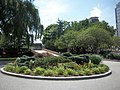 Charlesbank Traffic Circle
 -
 Edge of Charlesbank Traffic Circle
 -
 Edge of Charlesbank Traffic Circle


Front Entrance
Two large decorative stone urns grace both sides of the front entrance. A pine in the center of each decorative urn is surrounded by seasonal plantings.
-
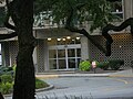 The front entrance to Charlesbank, as seen across the traffic circle from under a tree
 -
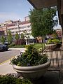 Charlesbank Decorative Flower Urns
 -
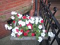 One of Charlesbank's front-side flower box planters


The northern side (facing Longwood Extension and [Massachusetts College of Art and Design MassArt]'s Smith Hall) and the eastern (back) side have large green perennial hastas. The back side (on St. Alphonsus Street) has two cultivars of azaleas (bushes). Smokers can only smoke on the azalea side of the building (though in early spring that view is among the most beautiful for contemplation).
Soils and Wind Tunnels
The Charlesbank campus is ___ soils and experiences a wind tunnel effect from the increasing number of high-rise buildings in the neighborhood. The wind tunnel effect often is felt strongly by pedestrians who cross at the intersection of Longwood and Huntington Avenue. This wind tunnel pressure, shade and sunlight variables and the soils partially determine which plants - flowers, shrubs, trees, and ivies - can survive and thrive in the flower beds and planters.[16][17]
Visibility from Charlesbank[edit]
From adequate height within the 24-story residential high-rise in Boston's Mission Hill are:
Athletic Buildings
Religious and Spiritual
- Mission Church, The Basilica and Shrine of Our Lady of Perpetual Help is a Roman Catholic basilica in the Mission Hill neighborhood of Boston, Massachusetts, sometimes known as "The Mission Church". The Redemptorists of the Baltimore Province have ministered to the parish since the church was first opened in 1870.[18]
- The Mosque for the praising of Allah
- Annunciation Greek Orthodox Cathedral of New England at 514 Parker Street at the eastern edge of the neighborhood (Byzantine-style architecture)
Academic Buildings
- The Harvard Medical School's 'Elsie' Building at 641 Huntington Avenue, which houses the HMS Department of Global Health and Social Medicine in what once were two buildings, 641 and 643 Huntington Avenue
- MassArt
- Smith Hall, a MassArt dormitory which predates Charlesbank
- Wentworth Institute of Technology
- Parts of Northeastern University
Harvard Teaching Hospitals - Medical Buildings
- Parts of the Brigham and Women's Hospital
- Tops of Boston Children's Hospital buildings
- Top of Dana–Farber Cancer Institute
Residential Buildings
- Three other residential towers in 'the triangle' between the rest of Mission Hill and the Longwood Medical Area - one under construction as part of The Longwood.
- Fort Point
- Mission Main (3-story residences - public housing)
Other Buildings
External Noises[edit]
Noises from Huntington Avenue (on the western side), also called Boston's Avenue of the Arts because the Museum of Fine Arts]], Massachusetts College of Art and Design (MassArt), the Gardner Museum, and the New England Conservatory and Jordan Hall are there, come from the MBTA Huntington Avenue E-Line (Green Line), heavy traffic volumes from automobiles, trucks, buses, and motorcycles.
Noises from St. Alphonsus Street come largely from early- to mid-morning traffic from northbound cars, buses, and delivery trucks stalled at the Longwood Extension, trying to turn left into the Longwood Medical Area, or to continue a short distance to an angled entry onto northbound Huntington Avenue, Mission Main residents (garrulous talking, thrill-seeking motorcycles, starting car engines, riding lawnmowers, door lock sirens in the morning, and police sirens - all wafting up the eastern side of the building), Medevac helicopters heading for heliports in the Longwood Medical and Academic Area, and conversations of hundreds - of thousands - of college students wafting up the eastern side of the building so clearly that residents halfway up the building can clearly understand every word and ponder the meanings of each undergraduate sentence, whether or not interest, factual, or funny.
A locally-based community health group, Mission Hill Health Movement, had worked with Harvard Chan School of Public Health to measure air quality and noise and vibration. MHHM's more focused concern was airborne toxins that would be measurable health harms, but the monitoring company had developed detection mechanisms to detect noise and vibration. A Harvard Chan School doctoral recipient was involved with MHHM in a noise detection and documentation project that extended far beyond Boston proper, but which included Mission Hill. y
Air Quality[edit]
Four rooftop fans - one very large intake fan and three exhaust fans (each responsible for eight of the 24 floors) - contribute to a quality indoor environment for each of the residential units, the offices, and the public spaces in the building. Each unit has an air conditioner and heating unit. Residents are responsible for their own air filtration.
On September 1, 2012, an indoor clean air policy went into effect. Unlike its next-door commercial neighbor, CityView at Longwood, which states a 100% no smoking policy for its entire building, Charlesbank is a transitional property where 'legacy residents' who sought a 'smoking policy waiver' were granted that waiver ('grandfathered in') and allowed to smoke in their units as long as no one complained about it. Arguably, such a policy is an imperfect compromise, since all residents and building users share the building envelope and exhaust from each unit in each of the 8-floor groups is sucked through all the other units, although in dissipated form.
At a Board meeting on Tuesday evening, January 26, 2016, the Charlesbank Board voted (two voted no) to implement a smoke-free building policy which had no smoking waivers. All 'smoking waivers' would be revoked as of July 1, 2016. Maloney Properties, the management office, would be required to implement that decision.
Later, the Board agreed that the 'designated smoking area' would be removed because 'it was not working' (for the interests of the shareholders).
Dust[edit]
Dust is a perpetual problem when unit windows are open. Allergens and particulate matter comes from vehicular exhaust, decomposition, and other common sources. Dust mitigation strategies have been recurring discussion topics among the residents.
Standing Committees[edit]
There are four (4) standing committees, each of which (by statute) is chaired by an elected Board member.
- Design Committee - Concerns all matters of interior design of the Charlesbank high-rise residential building
- Finance Committee - All Charlesbank's matters pertaining to revenue, budget, and spending and saving money
- Landscape Committee - Works with Management and Romeiro Landscaping to ensure a beautiful and durable landscape and clean, neat grounds and perimeter
- Newsletter Committee - Produces a high-quality 8-page quarterly print newsletter with interesting, useful, and noncontroversial content
Ad Hoc Committees[edit]
Ad Hoc committees include:
- Document Review Committee, which serves under the Clerk (an executive officer of the Board) in order to review primary legal documents and to consider their policy implications for the corporation and its shareholders, and its residents, employees, and contractors.
- Communications Committee - An ad hoc communications committee was formed to explore a full array of digital and other communications in the building and among the membership. Social scientists and other academics are encouraged to participate. One focus is to be the introduction of an electronic newsletter or an attached PDF version of the newsletter, and other digitized communications, to bolster rather than replace the print-based quarterly newsletter. See 'Internal Communications' below. It is possible that, if work is highly successful, the newsletter committee or function will be subsumed under a stronger, modernized Communications Committee.
- Communications Committee - to explore all possible methods of communicating within the building, among the membership, and across the Corporation, which includes reflecting upon the formal print methods (newsletter, one-way memoranda from management) and informal (conversation, digital communication).
- Environmental Committee - to explore all matters of living in the building and neighborhood that impact the health and well-being of Charlesbank's 300 residents, including air quality, noise, water quality, safety, cleaning products, etc.
Pending Committees[edit]
Several ad hoc committees had been authorized by various Boards (serving 2-year terms)
- History Committee - to explore and rationalize (make explicitly informational in an organized way) the background and past history of Charlesbank and how its current processes or ways of doing thing were developed.
- Environmental Committee - to address ecological issues (including eWaste and spent battery disposal) involved with everyday living in the building, and possible engagement with public (city and Commonwealth) and private partnerships (EV charging; foundations) for operating as 'better eco-citizens'
Internal Communications[edit]
Print Communications
- A weekly management-driven communication (with repeated sources of resident assistance) is produced and distributed electronically. In the past and today to a limited extent, management memoranda are distributed either door-to-door (rolled up and tucked between the door knob and the door frame) or in closed envelopes, claimed by the resident who receives a quarter-page notice in her or his mailbox (mailboxes are in the first floor lobby).
(needs update)
- For years, a professional quality 8-page quarterly newsletter was produced by resident contributors and organized by a Newsletter Editor, who served at the pleasure of the elected Board members. The editor was responsible for delivering the electronic version of the newsletter to The Print House (which had operated next door), with the purchase order, and for picking up the printed product and ensuring complete delivery to each resident's door. However, relocation of The Print House's satellite location, then the coronavirus pandemic, halted the resident-driven newsletter.
(needs update)
- Confidential communications from the Board or Committee heads to committee members is arranged by electronic e-mail or printed messages claimed by the recipients from the security guard's desk in the lobby.
(needs update)
- Several (informal) Facebook networks operate (with limited shareholder involvement).
Digitized Communications
- An ad hoc communications committee was formed (when? what year?) to explore a full array of digital and other communications in the building and among the membership. Social scientists and other academics are encouraged to participate. One focus is to be introduction of digitized communications to bolster rather than replace the print-based quarterly newsletter. Management personnel changes saw initiatives in this area; momentum in developing a common kshareholder-owned and shareholder-driven website was lost in part because of Board membership changes as 2-year terms ended.
- Informal e-mails are also sent around.
- Building residents have a choice of three communications services (Astound, formerly RCN; M; Verizon). No common WiFi is provided (other than for building heat management; hallway routers are visible).
- Several (informal) Facebook networks operate (with limited shareholder involvement).
- The Charlesbank Community Room, available to any resident by scheduling its use, has a large wall-screen television and video monitor, on which video displays can enhance small group events. Tables and chairs can be moved around.
Informal Member-to-Member Ad Hoc Communications
Residents can post freely on one (1) cork bulletin board outside the laundry room [formerly four (4) cork bulletin boards on opposing walls in the hallway leading to the Community Room, which was relocated during a building renovation], and official communications (from the Board, its officers, and the management) are posted on cork boards inside two locked glassed-in cases, one by the two elevators and the other outside the Community Room on the first floor, near the laundry room. (needs update)
See Also[edit]
- Huntington Avenue - Huntington Avenue is also known as the Avenue of the Arts
- Housing
- Affordable housing
- Median household income
- Housing Affordability Index
- Housing cooperative
References[edit]
- ^ Stubbins Named Designer For Countway Library, The Harvard Crimson, December 14, 1961
- ^ Great Buildings Online: Architect-Hugh Stubbins
- ^ O'Connor, Thomas H., The Hub: Boston Past and Present, Northeastern University Press Boston, 2001. ISBN 1-55553-474-0
- ^ O'Connor, Thomas H., The Hub: Boston Past and Present, Northeastern University Press Boston, 2001. ISBN 1-55553-474-0
- ^ O'Connor, Thomas H., The Hub: Boston Past and Present, Northeastern University Press Boston, 2001. ISBN 1-55553-474-0
- ^ Affordable nursing school housing is also found nearby on Brookline Avenue, at the end of the Longwood Medical Area, near other Colleges of the Fenway and the Landmark Center.
- ^ http://maps.google.com/maps/ms?ie=UTF8&hl=en&msa=0&msid=117936476199750036545.00000111c2561cd8c4ef4&ll=42.332471,-71.094933&spn=0.02519,0.079823&z=14&om=1
- ^ http://www.boston.com/realestate/news/articles/2008/03/16/the_best_zip_codes/
- ^ a b "Mission Hill: background information and planning issues, preliminary neighborhood improvement strategies", Boston Redevelopment Authority, (1975)
- ^ Mission Hill Building Project SMFA
- ^ Boston Open Studios Coalition
- ^ Diable Glass and Metal
- ^ A BRA September 20, 1961 meeting notice mentions the construction of the building.
- ^ Charlesbank Apartments Business Entity Summary with the Massachusetts Secretary of State's Office, a nonprofit corporation headquartered in Needham, MA, and dissolved involuntarily in 1998
- ^ CATA Business Entity Summary with the Massachusetts Secretary of State
- ^ Plants that aren't blown away by the wind
- ^ Windbreaks and shelterbelts: Gardens in exposed locations
- ^ "Redemptorists". bostonsbasilica.com.