
User:Waggers/sandpit/transclude images from long list
< User:Waggers | sandpit
General images -
The following are images from various South East England-related articles on Wikipedia.
-
 Flag of the historic county of Berkshire (from Berkshire)
 -
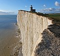
 View of the White Cliffs of Dover from France (from Kent)
 -
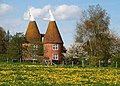
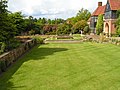 Lawns at RHS Garden, Wisley
 -
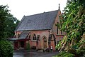
 Historic house (from Berkshire)
 -
 Southampton Docks (from Hampshire)
 -
 Mermaid Street in Rye showing typically steep slope and cobbled surface (from East Sussex)
 -
 Cliveden (from Buckinghamshire)
 -
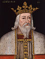
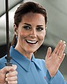 Catherine, Princess of Wales (from Berkshire)
 -
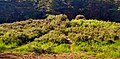
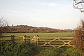
 accessible open space (from Berkshire)
 -
 The coat of arms of Surrey County Council (from Surrey)
 -
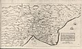
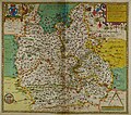 Hand-drawn map of Oxford, Buckinghamshire and Berkshire by Christopher Saxton from 1576. (from Buckinghamshire)
 -
 English Heritage (from Berkshire)
 -
 The flag of the historic county of Buckinghamshire (from Buckinghamshire)
 -

-
 County Hall, Lewes (from East Sussex)
 -
 Britain's first crematorium, in the Borough of Woking
 -
 Windsor Castle, viewed from the Long Walk (from Berkshire)
 -
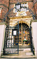 The gate of Abbot's Hospital, Guildford
 -

-
 Bucks County Council's County Hall (from Buckinghamshire)
 -
 Kent, as it appears in the Anglo-Saxon Chronicle between 11th and 12th centuries (from Kent)
 -
 The Oracle Corporation campus (from Berkshire)
 -
 Theatre at Glyndebourne (from East Sussex)
 -
 The River Thames at Medmenham (from Buckinghamshire)
 -
-
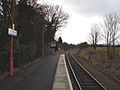 Little Kimble railway station, a typical rural village halt on the Aylesbury–Princes Risborough line (from Buckinghamshire)
 -
 Arms of East Sussex County Council (from East Sussex)
 -
 The Roald Dahl Museum and Story Centre, Great Missenden (from Buckinghamshire)
 -
Historic house (from Berkshire)
-

-
 1813/54 one inch to the mile OS map (from West Sussex)
 -
-
 A map showing the traditional boundaries of Surrey (c. 800–1899) and its constituent hundreds (from Surrey)
 -
Hand-drawn map of Oxford, Buckinghamshire and Berkshire by Christopher Saxton from 1576. (from Berkshire)
-
English Heritage (from Berkshire)
-
 Milestones Museum, Basingstoke (from Hampshire)
 -
 The coat of arms of West Sussex County Council (from West Sussex)
 -
 Kew Palace in 1835
 -

-
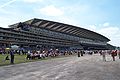 The grandstand at Ascot Racecourse (from Berkshire)
 -
 Hand-drawn map of Hampshire by Christopher Saxton from 1577 (from Hampshire)
 -
 Guildford Cathedral, designed by Edward Maufe
 -

-
 "Dragon's teeth" antitank obstacles by the River Wey
 -
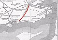
 Geological cross-section of Kent, showing how it relates to major towns (from Kent)
 -
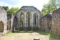 Ruins of the monks' dormitory at Waverley Abbey
 -
 Hand-drawn map of Kent, Sussex, Surrey and Middlesex from 1575 (from Surrey)
 -

-
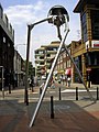 Statue of a Martian tripod from The War of the Worlds in Woking, hometown of science fiction author H. G. Wells
 -
 The coat of arms of Kent County Council (from Kent)
 -
accessible open space (from Berkshire)
-
 Suburban housing, Chesham (from Buckinghamshire)
 -
 Museum (free) (from Berkshire)
 -
 The flag of Surrey, representing the historic county (from Surrey)
 -
-
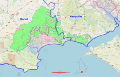 South West Hampshire & South East Dorset green belt (shown in green) (from Hampshire)
 -
Historic house (from Berkshire)
-
 Castle (from Berkshire)
 -
 Ricky Gervais (from Berkshire)
 -
 Canterbury Cathedral (from Kent)
 -
 Country park (from Berkshire)
 -
accessible open space (from Berkshire)
-
accessible open space (from Berkshire)
-

-
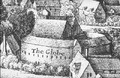 The second Globe theatre, built 1614
 -
Castle (from Berkshire)
-
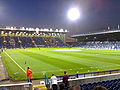 Fratton Park football ground, Portsmouth, from Milton End, 2006 (from Hampshire)
 -
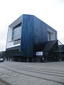
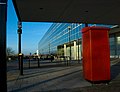
 City Council building in Central Milton Keynes (from Buckinghamshire)
 -
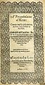 Title page of William Lambarde's Perambulation of Kent (completed in 1570 and published in 1576), a historical description of Kent and the first published county history (from Kent)
 -
accessible open space (from Berkshire)
-
-
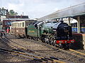
 Milton Keynes Central railway station provides intercity and commuter services on the West Coast Main Line (from Buckinghamshire)
 -
 Buckingham church seen from across the Ouse (from Buckinghamshire)
 -
-
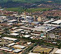 Slough Trading Estate plays a major part in making Slough a business centre in South East England (from Berkshire)
 -
-
Museum (free) (from Berkshire)
-
 Offices, Milton Keynes (from Buckinghamshire)
 -
 Wendover Dean (from Buckinghamshire)
 -
 National Trust (from Berkshire)
 -

-
 The flag of the historic county of Hampshire (from Hampshire)
 -
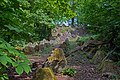
 View from Box Hill
 -
Hand-drawn map of Kent, Sussex, Surrey and Middlesex from 1575. (from Kent)
-
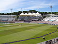 Utilita Bowl cricket ground, when it was known as the Ageas Bowl, West End, 2010 (from Hampshire)
 -
 A map of Romney Marsh "The history of imbanking and drayning" by William Dugdale (1662). (from Kent)
 -
Historic house (from Berkshire)
-

-
accessible open space (from Berkshire)
-
 The M40 in the Chilterns (from Buckinghamshire)
 -
Museum (free) (from Berkshire)
-
 Plaque on Freemantle Common marking the route of the Roman Road from Chichester to Bitterne (from Hampshire)
 -
 The Select Car Leasing Stadium in Reading (from Berkshire)
 -
 Epsom is famous for the Epsom Downs Racecourse which hosts the Epsom Derby; painting by James Pollard, c. 1835
 -
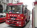 Dennis Sabre fire engine (from Surrey)
 -
 The coat of arms of Hampshire County Council (from Hampshire)
 -
 Ercol furniture factory, Princes Risborough (from Buckinghamshire)
 -
 Theme Park (from Berkshire)
 -
 Wakehurst Place Gardens, Ardingly (from West Sussex)
 -
Historic house (from Berkshire)
-
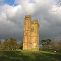 Leith Hill Tower
 -
accessible open space (from Berkshire)
-
 Portsmouth historic dockyard, 2005 (from Hampshire)
 -
 Export House in Woking, one of Surrey's tallest buildings
 -
 Local bus, Amersham (from Buckinghamshire)
 -
Museum (free) (from Berkshire)
-
National Trust (from Berkshire)
-
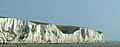 The White Cliffs of Dover (from Kent)
 -
accessible open space (from Berkshire)
-
Museum (free) (from Berkshire)
-
 The Royal Pavilion (from East Sussex)
 -
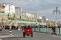 A 1903 De Dion-Bouton arrives in Brighton in the 2012 Veteran Car Run (from East Sussex)
 -
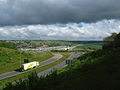
 The M3 near Basingstoke (from Hampshire)
 -
 The Dripping Pan, home of Lewes FC men's and women's teams (from East Sussex)
 -
 The Roman Stane or Stone Street runs through Surrey
 -
English Heritage (from Berkshire)
-
 Photograph of Portchester Castle in June 1938 (from Hampshire)
 -
 Runnymede, where Magna Carta was sealed
 -
-
English Heritage (from Berkshire)
-
 Stowe Landscape Garden (from Buckinghamshire)
 -
 General map of West Sussex. (from West Sussex)
 -
English Heritage (from Berkshire)
-
-
 Map of Bucks (1904) (from Buckinghamshire)
 -
 Eastleigh railway works (from Hampshire)
 -
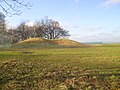 Neolithic Barrow, Whiteleaf Hill (from Buckinghamshire)
 -
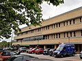
 Hampshire County Council offices and Jubilee Fountain (from Hampshire)
 -
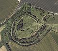 Danebury Fort – aerial image (from Hampshire)
 -
Country park (from Berkshire)
-
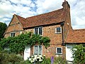 John Milton's cottage, Chalfont (from Buckinghamshire)


.jpg)
.jpg)


.jpg)

Apr2006.jpg)


.jpg)


_(May_2014)_(1).JPG)


.jpg)


.jpg)


