
User talk:Jason Rees/Archive1
Notes[edit]
Dear Tropical cyclone editor, As a member of the Tropical Cyclone Wikiproject, you are receiving this message to describe how you can better tropical cyclone articles. There are hundreds of tropical cyclone articles, though many of them are poorly organized and lacking in information. Using the existing featured articles as a guide line, here is the basic format for the ideal tropical cyclone article.
- Infobox- Whenever possible, the infobox should have a picture for the tropical cyclone. The picture can be any uploaded picture about the storm, though ideally it should be a satellite shot of the system. If that is not available, damage pictures, either during the storm or after the storm, are suitable. In the area that says Formed, indicate the date on which the storm first developed into a tropical depression. In the area that says Dissipated, indicate the date on which the storm lost its tropical characteristics. This includes when the storm became extratropical, or if it dissipated. If the storm dissipated and reformed, include the original start date and the final end date. Highest winds should be the local unit of measurement for speed (mph in non-metric countries, km/h in metric countries), with the other unit in parenthesis. The lowest pressure should be in mbars. Damages should, when available, be in the year of impact, then the present year. The unit of currency can be at your discretion, though typically it should be in USD. Fatalities indicate direct deaths first, then indirect deaths. Areas affected should only be major areas of impact. Specific islands or cities should only be mentioned if majority of the cyclone's effects occurred there.
- Intro- The intro for every article should be, at a minimum, 2 paragraphs. For more impacting hurricanes, it should be 3. The first should describe the storm in general, including a link to the seasonal article, its number in the season, and other statistics. The second should include a brief storm history, while the third should be impact.
- Storm history- The storm history should be a decent length, relatively proportional to the longevity of the storm. Generally speaking, the first paragraph should be the origins of the storm, leading to the system reaching tropical storm status. The second should be the storm reaching its peak. The third should be post-peak until landfall and dissipation. This section is very flexable, depending on meteorological conditions, but it should generally be around 3. Storm histories can be longer than three paragraphs, though they should be less than five. Anything more becomes excessive. Remember, all storm impacts, preparations, and records can go elsewhere. Additional pictures are useful here. If the picture in the infobox is of the storm at its peak, use a landfall picture in the storm history. If the picture in the infobox is of the storm at its landfall, use the peak. If the landfall is its peak, use a secondary peak, or even a random point in the storm's history.
- Preparations- The preparations section can be any length, depending on the amount of preparations taken by people for the storm. Hurricane watches and warnings need to be mentioned here, as well as the number of people evacuated from the coast. Include numbers of shelters, and other info you can find on how people prepared for the storm.
- Impact- For landfalling storms, the impact section should be the majority of the article. First, if the storm caused deaths in multiple areas, a death table would work well in the top level impact section. A paragraph of the general effects of the storm is also needed. After the intro paragraph, impact should be broken up by each major area. It depends on the information, but sections should be at least one paragraph, if not more. In the major impact areas, the first paragraph should be devoted to meteorological statistics, including rainfall totals, peak wind gusts on land, storm surge, wave heights, beach erosion, and tornadoes. The second should be actual damage. Possible additional paragraphs could be detailed information on crop damage or specifics. Death and damage tolls should be at the end. Pictures are needed, as well. Ideally, there would be at least one picture for each sub-section in the impact, though this sometimes can't happen. For storms that impact the United States or United States territories, this site can be used for rainfall data, including an image of rainfall totals.
- Aftermath- The aftermath section should describe foreign aid, national aid, reconstruction, short-term and long-term environmental effects, and disease. Also, the storm's retirement information, whether it happened or not, should be mentioned here.
- Records- This is optional, but can't hurt to be included.
- Other- The ideal article should have inline sourcing, with the {{cite web}} formatting being preferable. Always double check your writing and make sure it makes sense.
Good luck with future writing, and if you have a question about the above, don't hesitate to ask.
4F[edit]
Nadi Airport 24-hr rainfall data : 24h rs to 9am Thu 8 Jan : 100.1mm. 24 hrs to 9am Fri 9 Jan : 239.3mm 24 hts to 9am Sat 10 Jan : 102.9mm 24 hrs to 9am Sun 11 Jan : 280.8mm To date, 7 confirmed fatalities.
I wish there was a reference to this information (it might be worth checking out sites which contain SYNOP data such as Texas A&M.) Maybe you'll have better luck at the Nadi, Fiji website than I have. I have not been able to download their documents with flood images (the download is phenomenally snow)...I guessing it's the recent event, but since I can't download them, I don't know. FYI. Thegreatdr (talk) 01:18, 14 January 2009 (UTC)
Daman Sources[edit]
- [1], [2] [3] [4], [5] [6] [7] [8], [9] Note – this is only partially due to Daman, [10], [11], [12], [13], [14],
I'll keep adding more when I find them (Reason for links per IRC incase anyone is confused :P) Cyclonebiskit 14:23, 30 March 2009 (UTC)
Problem with Cyclone Cliff[edit]
While working on the retired Australian names template, I found that there was a Cyclone Cliff retired in 1981. This means that both articles will have to have the year in the title. Can you make a disambiguation page for this name too? Cyclonebiskit (talk) 14:11, 7 August 2009 (UTC)
- Later when i feel better :)Jason Rees (talk) 14:19, 7 August 2009 (UTC)
Favor[edit]
Can you find all the forecasts for AUS for this season and organize it in a seasonal forecasts table and ship it to my user talk page? Thanks, and Happy holidays! Darren23Edits|Mail 21:08, 25 December 2009 (UTC)
Thank You[edit]
Well, I am just here to say thank you for helping me while I was here in WP, and I am just wishing you luck on your future projects in the future. And no, I am not overreacting, but probably I will come back when I have a lot more time in my hands. Darren23Edits|Mail 22:48, 23 January 2010 (UTC)
Re: Disambiguation pages[edit]
Hello, I finished them. --Priyanka 02:48, 5 February 2010 (UTC)
Second opinion[edit]
Thank you for providing the helpful comment at Talk:Tropical Storm Heidi (1971)/GA1. --maclean (talk) 06:31, 5 February 2010 (UTC)
Please verify the output of your script before commiting[edit]
Please actually look at changes a script is doing before going with them. I reverted some of your changes to National Weather Service bulletin for New Orleans region because they are detrimental to readablity. --96.240.189.80 (talk) 19:20, 6 February 2010 (UTC)
- No there not - white spaces shouldnt be in articles as they are pointless.Jason Rees (talk) 19:22, 6 February 2010 (UTC)
A Quick Question:[edit]
Hello, I am planning to write a timeline for the 1982-83 SPac Season and I was wondering, who named the storms before Nadi was formed in the early 90's? Thank you, --Priyanka 17:23, 7 February 2010 (UTC)
Thanks! --Priyanka 18:08, 7 February 2010 (UTC)
Hallo Jason, at the moment I am trying to complete the German version of that article. As for the other basins than the Atlantic the tropical cyclones in the German WP are a one-man show I must most parts of these articles translate. However I did some coverage of Parma and Melor in the German Wikinews. This just for explaining. Now the issue. ;-)
The section about Parma is at the moment rather messy; it consists of one very long paragraph and another short one which doesn't appear on the right place chronically but is somewhat redundant as well. Since I saw that you are refurbishing the article would you mind if I try to rearrange this section and fill in some of my sources? --Matthiasb (talk) 07:48, 8 February 2010 (UTC)
hellllllo there, i was wondering if you could help me a bit. i was working on an article for hurricane paine in 1986, but there's a problem. most of the impact is related to a larger flooding event, and the hurricane only tagged along at the end. i'm not really familiar with flooding articles, and i don't want to lose the emphasis on the hurricane, but there wasn't much impact directly from the hurricane. any suggestions? --Viennaiswaiting (talk) 21:32, 10 February 2010 (UTC)
- I encountered a similar dilemma with Tropical Storm Heidi (1971). Just include a summary of the flooding that took place and explain the hurricane's affiliation with it. –Juliancolton | Talk 21:39, 10 February 2010 (UTC)
- ok, i think i got the idea. thx bro --Viennaiswaiting (talk) 21:45, 10 February 2010 (UTC)
Can I ask what you meant when you said "Thats not allowed" with regards to my renaming of the duplication section headers to make them unique? Thanks! VernoWhitney (talk) 15:37, 23 February 2010 (UTC)
- Its simple you are not allowed to add numbers like that - its counted as OR.Jason Rees (talk) 15:38, 23 February 2010 (UTC)
- Ok, since you appear to be involved with this and other related cyclone season articles, do you know of a way to differentiate the different Depressions and bring the articles in line with the WP:Headings guideline without finding a source which would make it not OR? I'm just trying to be a dilligent WikiGnome here, so if there's not a standard way to do it without a source, just say so and I'll drop it unless I can track something down to support a change. VernoWhitney (talk) 15:48, 23 February 2010 (UTC)
- The IMD does apply the designations ARBXX or BOBXX (XX=number), but id need to research the designations before adding them in to that season.Jason Rees (talk) 15:59, 23 February 2010 (UTC)
- I appreciate that information. The next time I get the urge to work on this article (or any of the related ones) I can look into that. If it's not bothering you then there's no reason you should have to do extra work. Thanks again! VernoWhitney (talk) 16:15, 23 February 2010 (UTC)
- The IMD does apply the designations ARBXX or BOBXX (XX=number), but id need to research the designations before adding them in to that season.Jason Rees (talk) 15:59, 23 February 2010 (UTC)
- Ok, since you appear to be involved with this and other related cyclone season articles, do you know of a way to differentiate the different Depressions and bring the articles in line with the WP:Headings guideline without finding a source which would make it not OR? I'm just trying to be a dilligent WikiGnome here, so if there's not a standard way to do it without a source, just say so and I'll drop it unless I can track something down to support a change. VernoWhitney (talk) 15:48, 23 February 2010 (UTC)
- Its simple you are not allowed to add numbers like that - its counted as OR.Jason Rees (talk) 15:38, 23 February 2010 (UTC)
New Messages[edit]

You may remove this notice at any time by removing the {{newmessages}} template.
112.203.184.112 (talk) 07:22, 14 March 2010 (UTC)
Cyclone Edzani[edit]
So does this cyclone deserve an article? And if so, can someone make it? 112.203.184.112 (talk) 12:40, 15 March 2010 (UTC)
Where hurricanes lie[edit]
Last I checked, the Indian ocean and western Pacific don't use the hurricane term. The Southeast Pacific does, however. Since the Brazilian Navy has never clarified which term is used in the South Atlantic, we really don't know what term to use down there. Tropical cyclone is nice and generic and covers everything. Cyclone and hurricane should be avoided, until the Brazilian Navy takes the lead on what terminology they wish to use for the southern Atlantic. Thegreatdr (talk) 00:18, 16 March 2010 (UTC)
- Nevermind. A little digging, including a read of the Catarina article, found this link which states they plan to use the hurricane term, which is used everywhere else in the Western Hemisphere. I'm going to have to revert your change. Thegreatdr (talk) 00:31, 16 March 2010 (UTC)
- American Samoa uses the term hurricane as well in their warnings. Thegreatdr (talk) 03:54, 16 March 2010 (UTC)
Edzani[edit]
So can you now continue with your sandbox at User:Jason Rees/Edzani? Narutolovehinata5 tccsdnew 11:58, 24 March 2010 (UTC)
The main problems I see with the article (now that the enormous task of referencing appears to be done) are that it does not have a lead summarizing the article below, and that a couple of the sections (southern Indian Ocean, southwest Pacific) don't have a paragraph summarizing a history of their naming, which the other sections do. Once those problems are solved, I'd imagine sending the list to featured status would be a snap. To be more certain, ask Juliancolton who has more experience getting through the featured list process than I do. I only have one right now, the one dealing with List of wettest tropical cyclones in the United States. Thegreatdr (talk) 17:48, 25 March 2010 (UTC)
W/C[edit]
Depends on what they (whoever "they" are) mean by "soon"! The deletions from my archive are done manually and I always stop doing this when WebCite is on the blink. Hopefully this will happen less often on its new server.--Keith Edkins ( Talk ) 21:36, 25 March 2010 (UTC)
GA Review[edit]
I reviewed your article on 1990 Andhra Pradesh cyclone and put it on hold. The biggest problem is the writing, both in awkward phrasing and run-ons. You have seven days to address my concerns. ♬♩ Hurricanehink (talk) 04:12, 7 April 2010 (UTC)
Template:Hurdat[edit]
Hey thanks for the help with the Hurdat template data for Hurricane Henri (1979). I'm curious how you got the data in that particular format, because I'd like to get it for Hurricane Dolly (2008) as well which also passed very near Scorpion Reef. Thanks -Marcusmax(speak) 02:46, 15 April 2010 (UTC)
- Oh okay thank you, this Hurdat data is really good for figuring any direct hits by Tropical Cyclones. -Marcusmax(speak) 02:52, 15 April 2010 (UTC)
- Ooh with Hurricane Henri that would be quite hard to determine. I can tell you with 100% certainty that it passed directly over Scorpion Reef however without further data I can't tell if it went directly over an island but it certinally passed within at least 10 miles of one in the group. -Marcusmax(speak) 21:41, 15 April 2010 (UTC)
2010 North Indian Ocean Cyclone Season[edit]
Hello Jason ! I would just like to comment about the 2010 North Indian Ocean Cyclone Season. Because I seen that you removed my edit about the unknown cyclone that hit eastern India past days ago. and I just wan't you to ask a question. Did I broke again the rules in Wikipedia? But I have a reliable source and references. thanks. take care. God bless. Jpuligan_12 (talk) 2010-04-17 18:20 (UTC).
ah ok. hahahaha. thanks for correcting me. god bless :) Jpuligan_12 (talk) 2010-04-17 19:38 (UTC).
Wind Speeds[edit]
Out of curiosity, the convert template is not used for wind speeds? -Marcusmax(speak) 02:42, 29 April 2010 (UTC)
I'm pretty sure Ivan would be #5 on that template you made. Per the WMO, it did $1.2 billion in 2004 USD, which would be $1.38 billion in 2010 USD. The problem is that the WMO link in the Ivan article is down, and it doesn't seem the WMO has the reports archived pre-2005. I'll try and find another link for that damage total.
BTW, if you were to make that a top ten, the next few would be Charley, Wilma, and Kate 85. Hurricanehink (talk) 15:57, 4 May 2010 (UTC)
Template: Infobox Hurricane[edit]
Hello. I've been trying to clean up broken anchor links on various tropical storm articles, and noticed that for the Aus and SPac basins the Hurricane Infobox template links to Australian scale, which looks like this [[Tropical cyclone scales#Categories and ranking|Australian scale]], but the Categories and ranging section is no longer in the article. Linking to Australian scale [[Tropical cyclone scales#Australia|Australian scale]] seems to be the right thing to do instead. I played with it on the sandbox/testpage and it worked well, and tried fixing the template, but it didn't seem to change anything. I don't know if it takes some time for the changes to take effect (I tried clearing the browser cache), but for now I have reverted my changes just in case. Could you take a look at it if you get a chance? Thanks. Winston365 (talk) 20:22, 6 May 2010 (UTC)
- Ok, cool. It is working for me now for some storms, ie. Cyclone Xavier (2006) and Cyclone Urmil (2006) (both of which I edited recently), but not yet for some others, ie. Cyclone Tam (2006) and the storms you linked me (Cyclone Tracy and Cyclone Lin (2009)). I suspect it's just some technical issues with wikipedia and they'll all come around sooner or later. Checking my watchlist reports "Due to high database server lag, changes newer than 2,079 seconds may not appear in this list." I've never seen it anywhere near that bad before, so I suspect there may be a clog in the tubes somewhere. Thanks very much for looking into it for me. Winston365 (talk) 22:01, 6 May 2010 (UTC)
A Favor Please...[edit]
Hello,
I am currently working on a timeline for the 03-04 SPac season here: User:Anhamirak/0304. For the image of Cyclone Heta, I do not know what to put for the alternate text. Do you know by any chance, what I should put?
Thanks,
--Yueof theNorth 19:55, 14 May 2010 (UTC)
Thanks for the help!
--Yueof theNorth 20:02, 14 May 2010 (UTC)
Hello...[edit]
Hello, I noticed that you reviewed 03-04 SPac timeline. Could you possibly tell me somethings that I need to improve? Thanks! --Yueof theNorth 19:19, 15 May 2010 (UTC)
OK, so you didn't like the heading changes I made here. The reason I made them was that this article is showing up on this error list because of the duplicate headings. Do you have a better suggestion of how to make the headings unique? --Auntof6 (talk) 04:15, 21 May 2010 (UTC)
- There is no doable way of making them unique and personally i dont see the need of them needing to be unique.Jason Rees (talk) 13:45, 21 May 2010 (UTC)
- It's here in the Wikipedia style manual. I thought the way I did it was doable. Did you have a specific problem with that method? You can reply here, because I am watching your talk page. --Auntof6 (talk) 18:51, 21 May 2010 (UTC)
- That says its optional, and the way you did it you added the wrong dates and i dont personally think its worth it because several articles use duplicate headers and they have passed FAC.Jason Rees (talk) 20:48, 21 May 2010 (UTC)
- OK, sorry for using the wrong dates. What if I used the dates in the accompanying images? I'm not asking you to make the change -- I will make it. --Auntof6 (talk) 21:04, 21 May 2010 (UTC)
- i cant remember whether we will have this problem with 2009 PTS but sometimes we can have more than 1 depression forming on a day so we would have the same problem.Jason Rees (talk) 21:15, 21 May 2010 (UTC)
- OK, sorry for using the wrong dates. What if I used the dates in the accompanying images? I'm not asking you to make the change -- I will make it. --Auntof6 (talk) 21:04, 21 May 2010 (UTC)
- That says its optional, and the way you did it you added the wrong dates and i dont personally think its worth it because several articles use duplicate headers and they have passed FAC.Jason Rees (talk) 20:48, 21 May 2010 (UTC)
- It's here in the Wikipedia style manual. I thought the way I did it was doable. Did you have a specific problem with that method? You can reply here, because I am watching your talk page. --Auntof6 (talk) 18:51, 21 May 2010 (UTC)
Hi Jason ! You have deleted some of my edits. mind ... can I ask you why ? Even you deleted the "Cyclone Yemyin" from "See Also" section ??? and about the upgradating of the cyclone system into "Very Severe Tropical Cyclone" by the Pakistan Meteorological Department, although its reference is already given ??? --Zubair71 (talk) 15:57, 2 June 2010 (UTC)
- 1) Yemyin is not relevant
- 2) PMD did not upgrade Phet into a VSCS - they follow what the IMD say.Jason Rees (talk) 15:59, 2 June 2010 (UTC)
- Jason ... About Yemyin to be "not relevant" may be your personal opinion, but a "Senior Meteorologist's" view considers it to be the "most relevant" to the concerned region. May I ask you to revert this, so include "Cyclone Yemyin" into the "See Also" section. Zubair71 (talk) 16:12, 2 June 2010 (UTC)
- How is it relevant? AFAIK the last TC's to affect Pakistan were ARB 01/02 of last year.Jason Rees (talk) 16:15, 2 June 2010 (UTC)
- Jason ... About Yemyin to be "not relevant" may be your personal opinion, but a "Senior Meteorologist's" view considers it to be the "most relevant" to the concerned region. May I ask you to revert this, so include "Cyclone Yemyin" into the "See Also" section. Zubair71 (talk) 16:12, 2 June 2010 (UTC)
- Then the "Cyclone Nargis" should also be deleted from "See Also" section, as it is "more irrelevant" ? Zubair71 (talk) 16:19, 2 June 2010 (UTC)
- Nargis is only there because it was the last equiv hurricane ill probably end up substituting it for a link to the List of the most intense tropical cyclones should Phet qualify. Anyway i dont mind adding it but i just need to know how it is relevant - im probably just overlooking something.Jason Rees (talk) 16:24, 2 June 2010 (UTC)
- Then the "Cyclone Nargis" should also be deleted from "See Also" section, as it is "more irrelevant" ? Zubair71 (talk) 16:19, 2 June 2010 (UTC)
Re: Phet/ARB 01 2001[edit]
I did, I specified the lead of ARB 01 2001 to state it's the second strongest by barometric pressure. Oficially, the IMD has ARB 01 as a much stronger storm than Phet so it doesn't really matter. Cyclonebiskit (talk) 16:29, 3 June 2010 (UTC)
WikiProject Futurama revival[edit]
Hello. WikiProject Futurama is being revived. Since you are listed as a participant here, you have received this message to make sure you still are. If you like to help update the WikiProject, please discuss here. Hopefully you can stay with us and continue to work on Futurama-related articles. GamerPro64 (talk) delivered by MuZebot 06:44, 6 June 2010 (UTC)
Cyclone Phet's Position[edit]
Hi, you know that cyclone phet is the second strongest cyclone not 2001 india cyclone and there are some problems with the names of Cyclon 2a and 3a please check that. talk 23:20, 7 June 2010 (UTC)
- No its not the second strongest cyclone in the Arabian sea as the official warning center (The IMD) for the Arabian sea only reported a pressure of 960hpa where as the IMD reported a peak pressure of 932 for the 2001 India Cyclone. RegardsJason Rees (talk) 18:26, 7 June 2010 (UTC)
Hi its me agian, Cyclone phet is the 2nd strongest cyclone in the arabian sea since it was a category 4 and 2001 cyclone was category 3... I also note that i had removed this line "37 people killed in punjab due to outer flow of phet"...thats wrong the storm that hit upper parts of Pakistan was due to a strong Western Disturbance. So please make that correction as senior Pak met office head also said the same things..--15jan19932010 (talk) 07:14, 8 June 2010 (UTC)
- Cyclone Phet is not the 2nd strongest cyclone in the Arabian sea as the IMD who are the official warning agency for the Indian Ocean only reported a pressure of 960hpa also the strongest cyclone is measured by pressure and not using windspeeds.Jason Rees (talk) 13:29, 8 June 2010 (UTC)
- Until we get an official source saying Phet was stronger than initially thought, and that its pressure was much lower, we can't call it the second strongest cyclone in the Arabian Sea. Now, you could call it the second strongest named cyclone, but naming is trivial considering they've only had it for 6 years. Hurricanehink (talk) 14:23, 8 June 2010 (UTC)
Gale percentage needed for Atlantic tropical storms - virtually zero[edit]
One wind report from QuikScat (or equivalent), land, or ship report which is outside severe-type convection that can occur during vertical wind shear situations. That's all. No "gales must cover two or more quadrants of its circulation for it to be considered a tropical storm." Thegreatdr (talk) 21:06, 7 June 2010 (UTC)
- It would be the same for the whole Western Hemisphere where tropical cyclone advisories are written, I do believe. Thegreatdr (talk) 23:24, 7 June 2010 (UTC)
Hello...[edit]
Hello Jason,
I saw your userpage with resources on it. By any chance, would you know any online location with TCWC Wellington books from the 1970's?
Thanks! --Yueof theNorth 21:04, 14 June 2010 (UTC)
- Afraid not - It might be worth checkiong NIWA'S site though.Jason Rees (talk) 12:07, 15 June 2010 (UTC)
Re: Conson[edit]
Good afternoon! yes Jason I am willing to help you. Woeh, as of now, I'm experiencing here in Manila a very heavy rain with gusty winds. I hope that my internet will not get shut down. Anyway, I can assure you that I will help you. Just leave a message in my talkpage if you just need me. Thanks! God bless you! Jpuligan_12 (talk), July 12, 2010 (10:03 UTC). :)
Hello Jason. I will work on the main article of Conson tomorrow. My internet and power supply just restored 5 mins ago. wooh! what a great typhoon. Many roofs were flying and trees are uprooted. I think the eyewall of Conson passed our house. But thank God, we survived! :) Jpuligan_12 (talk), July 14, 2010 (15:30 UTC). :P
wahahaha. Thanks. I will improve that article in today and in the next days. I am currently gathering informations about Conson. Have a nice day! God bless ypu! :) Jpuligan_12 (talk), July 15, 2010 (14:46 UTC).
Imagery[edit]
Ahh sorry just saw your message it seems we already have one put up at this point, but are you looking for something other then the standard MODIS image. -Marcusmax(speak) 02:06, 14 July 2010 (UTC)
- Uuugh, its always hard finding images for WPAC systems because NASA puts favor on the ATL and EPAC with their satellites. I'll look around -Marcusmax(speak) 02:32, 14 July 2010 (UTC)
- Digging through the modis archive I found this image of the cyclone while still a TS on the Saphir Simpson Scale, here is the link I figure once I find the top part I can rotate the images together and create one unified picture. Just a thought. -Marcusmax(speak) 03:07, 14 July 2010 (UTC)
Depression 97W[edit]
The Tropical Depression of 97W at East China Sea has just already dissipated at 8pm of 20 July,2010. As HKO had just said it. See this website of HKO and its weather maps. So please don't change it to "Still active" anymore for a low pressure area when it's no longer to be a tropical depression! Thank you!
Bowen9314 (talk), July 21, 2010 (00:03 UTC).
PAGASA retirees[edit]
Hello,
By any chance, would you know a source for the older PAGASA retirees or any of the pre-2000 JTWC retirees?
Thanks,
--Yueof theNorth 00:12, 23 July 2010 (UTC)
Hurricane Grace[edit]
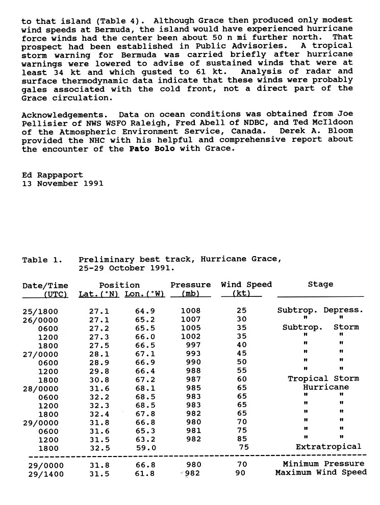
I see you changed my edit of the above page by reverting to 100 mph equals 155 km/h. Seeing as the actual figure is 160.934 km/h I don't understand why you did this? What do you mean by "Actually that is right", your figure or mine? Metricmike (talk) 21:28, 31 July 2010 (UTC)
- The figure quoted in the article was correct - as the peak windspeeds were 85kts which equals 155km/h and not 160km/h.Jason Rees (talk) 21:37, 31 July 2010 (UTC)
- It did not say knots, it said miles per hour, where did you get the knots from?Metricmike (talk) 00:49, 1 August 2010 (UTC)
- The source. Jason Rees (talk) 00:52, 1 August 2010 (UTC)
- According to http://www.nhc.noaa.gov/archive/storm_wallets/atlantic/atl1991-prelim/grace/prelim04.gif the maximum wind was 90 knots on the 29th at 1400 UTC. This would make it 166 km/h or 103.5 mph. Metricmike (talk) 01:01, 1 August 2010 (UTC)
- HURDAT only confirms peak winds of 100 mph (85 kts). It looks like they operationally believed it reached higher wind speeds for a short period between advisories, but we prefer to go by HURDAT whenever possible. 69.121.245.182 (talk) 01:09, 1 August 2010 (UTC)
- Here again though it talks about a 100 mph or 160 km/h wind, it mentions nothing about knots. It's obvious by the numbers they are rounded to the nearest 5 mph or 10 km/h. So why change it, the Convert template is obviously accurate, your source states 160 km/h, mine states knots which gives 165 km/h rounded to the nearest 5 km/h. Which source should we use? Metricmike (talk) 02:05, 1 August 2010 (UTC)
- Why add the convert templates when they are wrong?. The official database [15] at NHC says 85kts whcih we will use since thats better than the report youve cited and when converted equals 155km/h. Also compare the convert template to the infobox in this revison. Their not the same where as in the version after it they are, and before you go blaming the infobox i know the infobox is correct. as my page notice says "the original value is in Knots and has already been correctly converted to km/h and mph already".Jason Rees (talk) 02:26, 1 August 2010 (UTC)
- Here again though it talks about a 100 mph or 160 km/h wind, it mentions nothing about knots. It's obvious by the numbers they are rounded to the nearest 5 mph or 10 km/h. So why change it, the Convert template is obviously accurate, your source states 160 km/h, mine states knots which gives 165 km/h rounded to the nearest 5 km/h. Which source should we use? Metricmike (talk) 02:05, 1 August 2010 (UTC)
- The source. Jason Rees (talk) 00:52, 1 August 2010 (UTC)
- It did not say knots, it said miles per hour, where did you get the knots from?Metricmike (talk) 00:49, 1 August 2010 (UTC)
- The figure quoted in the article was correct - as the peak windspeeds were 85kts which equals 155km/h and not 160km/h.Jason Rees (talk) 21:37, 31 July 2010 (UTC)
Sina and Lisa[edit]
Done --Yueof theNorth 16:49, 1 August 2010 (UTC)
Arithmetic[edit]
Hi,
Hi you said the convert template is wrong. If it is, it can be fixed. It's just arithmetic. Can you tell me why it shouldn't convert 100 mph into 160 km/h? Lightmouse (talk) 22:26, 1 August 2010 (UTC)
- Because its the wrong conversion. According to the warning center the peak windspeeds were measured at 85kts which equals 155km/h and not 160km/h.Jason Rees (talk) 22:43, 1 August 2010 (UTC)
I'm confused. The article doesn't mention 85 kn. Lightmouse (talk) 10:19, 2 August 2010 (UTC)
- The official database [16] at NHC says 85kts which when converted equals 155km/h not 160km/h.Jason Rees (talk) 12:28, 2 August 2010 (UTC)
Ah. The arithmetic of converting 85 knots produces 157.42 km/h. It then needs a choice of precision. I wouldn't say 160 km/h is wrong and 155 km/h is right. They're merely different levels of precision. I take it that you prefer a precision of 5 mph and 5 km/h. The article also contains '75 mph' and '70 mph'. What were the original values in knots? Lightmouse (talk) 13:08, 2 August 2010 (UTC)
- 60 & 65kts.Jason Rees (talk) 17:26, 2 August 2010 (UTC)
Thanks. I've added the values in knots. I've set the precision to -1 which is the nearest 10 mph and 10 km/h. With the source value there, it seems acceptable. Lightmouse (talk) 17:49, 2 August 2010 (UTC)
- No rounding it to the nearest 10 is not acceptable. We need it to match the infobox which correctly says 155 km/h. If this isnt possible then i suggest that the convert templates are removed. Also please see this Discussion as i think its relevant.Jason Rees (talk) 21:00, 2 August 2010 (UTC)
- Finally, any typical conversion, now, can be rounded to the nearest 5 by using new option "disp=5". For 85 knots (kn):
- {{convert|85|kn|km/h|disp=b}} → 85 knots (157 km/h)
- {{convert|85|kn|km/h|disp=5}} → 85 knots (155 km/h)*
- However, storm data has the additional concern that conversion might be based on unknown speeds in knots, so for that reason, very often the conversions are hand-coded into an article (hand-copied from the source data). Perhaps if the conversions have been omitted in a particular source advisory, such as NHC, then use {convert} with an internal note of usage ONLY because the source did not report the conversion amounts. People often wonder why mph does not match km/h, while unaware that both were rounded from an unknown speed in knots. -Wikid77 (talk) 06:37, 4 August 2010 (UTC)
Re: Indirect deaths[edit]
The articles are being very cautious about connecting it to Dianmu and don't explicitly state that Dianmu was a major factor. All the storm may have done is brought up a moist, tropical air mass which then led to the downpour. Until there is a direct link that isn't being cautiously worded, it's best not to include it. Cyclonebiskit (talk) 17:26, 11 August 2010 (UTC)
- I may be able to explain it better to him when I get home later today; which should be in a little over three hours. Cyclonebiskit (talk) 17:34, 11 August 2010 (UTC)
Redirects[edit]
Hello, you recently created the pages Cyclone Fiona, Tropical Storm Fern, Tropical Storm Flora, and Typhoon Flo; each of these is a redirect to itself, which is useless to readers. If you can fix these redirects to point to existing Wikipedia articles, please do. Otherwise, they are likely to be deleted. --R'n'B (call me Russ) 10:57, 16 August 2010 (UTC)
Hi, I noticed you reverted Casliber's edit to WP:GAN. Was this intentional? As you've not challenged his other edits related to the promote [17] [18], I though it might be a mistake. Nev1 (talk) 23:06, 17 August 2010 (UTC)
- Yeah it was accidental - i didnt realise id done it.Jason Rees (talk) 23:21, 17 August 2010 (UTC)
1990-91 SPAC[edit]
Hello,
I was going to tell you that the timeline passed FLC, but I see you already found out ;).
Thanks for all the help!
--Iuneof theEast 02:12, 21 August 2010 (UTC)
Saffir–Simpson Hurricane Scale[edit]
Just curious to understand why Hurricane_Katrina is a bad choice? AFAIK it is a category 5 Hurricane and probably more widely known than others category 5 Hurricanes. -Abhishikt 23:05, 2 September 2010 (UTC) —Preceding unsigned comment added by Abhishikt (talk • contribs)
ITN: Typhoon Kompasu (2010)[edit]
| On 3 September 2010, In the news was updated with a news item that involved the article Typhoon Kompasu (2010), which you created. If you know of another interesting news item involving a recently created or updated article, then please suggest it on the candidates page. |
-- tariqabjotu 19:38, 3 September 2010 (UTC)
SPAC[edit]
Thanks ! :)
— Iune(talk) 14:55, 8 September 2010 (UTC)
IRC[edit]
Hey theres no one on that irc page u told me about :P M. Kaefer (talk) —Preceding undated comment added 02:07, 12 September 2010 (UTC).
Thanks[edit]
Thanks for the citation toolbar. At first I was overwhelmed by the pages and pages of unnessisary info that seems to accompany Wikipedia instructions, but once I weeded through the wiki-language, I figured out how to obtain it and use it. I have a long row to how (80 or 90 sources) but this helps. Thanks again.--Ishtar456 (talk) 23:40, 21 September 2010 (UTC)
Just to be safe...[edit]
I just want to call this now and not be questioned so I can most likely gloat later today :P
It looks like Paula is getting ready to rapidly develop and could become a major hurricane by as early as tomorrow morning. Cyclonebiskit (talk) 17:01, 12 October 2010 (UTC)
- We will see but going by the latest windspeed probs its only got about a 5% chance of even making it to MH status. Maybe once it gets into the GOM.Jason Rees (talk) 17:10, 12 October 2010 (UTC)
- BTW, recon just found 105mph winds ;) Cyclonebiskit (talk) 17:11, 12 October 2010 (UTC)
- With all the special conversions to get proper surface winds, Paula has confirmed winds of 83.8 knots (96.4mph) making it a low-end Cat:2 (by rounding it will be bumped up to 85kts (100mph). [19] Cyclonebiskit (talk) 17:16, 12 October 2010 (UTC)
- BTW, recon just found 105mph winds ;) Cyclonebiskit (talk) 17:11, 12 October 2010 (UTC)
Hey, I'm pretty sure I said last night on IRC that it'd be a major today :P Hurricanehink (talk) 17:17, 12 October 2010 (UTC)
- I said definite major 'cane (no time specified) but no one else agreed with me...(you weren't on at the time hink) Cyclonebiskit (talk) 17:19, 12 October 2010 (UTC)
- So wheres this major hurricane Paula?Jason Rees (talk) 23:14, 13 October 2010 (UTC)
JasonRees mutters something under his breath about it being flamin typical that Cyclonebiskit found a recon ob supporting 105 mph. :PJason Rees (talk) 17:21, 12 October 2010 (UTC)
- Hehehe, you know I'm better at forecasting storms in the ATL JR :P Cyclonebiskit (talk) 17:23, 12 October 2010 (UTC)
- Do i? :PJason Rees (talk) 21:23, 13 October 2010 (UTC)
- Hehehe, you know I'm better at forecasting storms in the ATL JR :P Cyclonebiskit (talk) 17:23, 12 October 2010 (UTC)
Product: Air Force Vortex Message (URNT12 KNHC)
Transmitted: 12th day of the month at 17:17Z
Aircraft: Air Force Aircraft (Last 3 digits of the tail number are 302)
Storm Number & Year: 18L in 2010
Storm Name: Paula (flight in the North Atlantic basin)
Mission Number: 3
Observation Number: 06
A. Time of Center Fix: 12th day of the month at 17:02:10Z
B. Center Fix Coordinates: 18°41'N 85°49'W (18.6833N 85.8167W)
B. Center Fix Location: 163 miles (262 km) to the E (85°) from Chetumal, Quintana Roo, México.
C. Minimum Height at Standard Level: 1,291m (4,236ft) at 850mb
D. Estimated (by SFMR or visually) Maximum Surface Wind: 92kts (~ 105.9mph)
E. Location of the Estimated Maximum Surface Wind: 6 nautical miles (7 statute miles) to the ENE (57°) of center fix
F. Maximum Flight Level Wind Inbound: From 137° at 93kts (From the SE at ~ 107.0mph)
G. Location of Maximum Flight Level Wind Inbound: 9 nautical miles (10 statute miles) to the NE (55°) of center fix
H. Minimum Sea Level Pressure: 982mb (29.00 inHg)
I. Maximum Flight Level Temp & Pressure Altitude Outside Eye: 17°C (63°F) at a pressure alt. of 1,524m (5,000ft)
J. Maximum Flight Level Temp & Pressure Altitude Inside Eye: 27°C (81°F) at a pressure alt. of 1,520m (4,987ft)
K. Dewpoint Temp (collected at same location as temp inside eye): 13°C (55°F)
K. Sea Surface Temp (collected at same location as temp inside eye): Not Available
L. Eye Character: Closed Wall
M. Eye Shape & Diameter: Circular with a diameter of 8 nautical miles
N. Fix Determined By: Penetration, Radar, Wind, Pressure and Temperature
N. Fix Level: 850mb
O. Navigation Fix Accuracy: 0.02 nautical miles
O. Meteorological Accuracy: 1 nautical mile
Remarks Section - Remarks That Were Decoded...
Maximum Flight Level Wind: 93kts (~ 107.0mph) in the northeast quadrant at 16:59:10Z
Remarks Section - Additional Remarks...
EYEWALL RAGGED
Cyclonebiskit (talk) 17:27, 12 October 2010 (UTC)
Cyclone yemyin[edit]
what was fake about it??? it was a pak-indo conflict that lead the IMD to neglect it even though it was a category 1 hurricane as shown in ref and image(clearly it had an eye)...15jan19932010 (talk) 03:58, 17 October 2010 (UTC)
- We cannot use information that is obtained through non-official research (see WP:OR). If you really feel that strongly about it, send an email to the IMD and ask about it. Cyclonebiskit (talk) 04:05, 17 October 2010 (UTC)
re: IRC[edit]
Hah, not really, just busy IRL. --Hurricanehink (talk) 16:39, 17 October 2010 (UTC)
- No one cares about WPAC :P Hurricanehink (talk) 16:46, 17 October 2010 (UTC)
Typhoon Megi[edit]
Fair enough. Ugh, The Philippines impact section needs a rewrite. --Blackmane (talk) 00:07, 22 October 2010 (UTC)
- Yeh I'm holding off on doing major edits to it for a little bit. Still the weekend is coming so there'll be time for it --Blackmane (talk) 00:38, 22 October 2010 (UTC)
IMD Tracking Data[edit]
Here is a centralized file [20]. I updated it to Giri 0000z at 10/22.
— Iune(talk) 03:17, 22 October 2010 (UTC)
Cyclone giri[edit]
Can you explain me why you change 125 knots to 135, the current advisory (advisory 6) only displays 125 knots and advisory 7 hasn't been issued yet. --Anirudh Emani (talk) 12:56, 22 October 2010 (UTC)
- Thank You very much. --Anirudh Emani (talk) 13:05, 22 October 2010 (UTC)
2010-11 Australian region cyclone season forecast[edit]
Hi Jason, as I am preparing the German version of that season's article I am wondering why you commented out the prediction of the TCWCs for the regions. Could you enlighten me? --Matthiasb (talk) 19:48, 22 October 2010 (UTC)
17[edit]
yeah it can be like that, but once it has completely dissipated into a remnant and now again became a tropical depression, i thought we should maintain a separate box for the system. --Anirudh EmaniSay something 10:43, 28 October 2010 (UTC)
Re: Favour[edit]
| Season | RSMC # | JTWC # | TD | TS | C1 | C2 | C3 | C4 | C5 |
|---|---|---|---|---|---|---|---|---|---|
| 69-70 | 7 | 12 | 2 | X | X | X | X | X | X |
| 70-71 | 8 | 6 | 2 | 1 | X | X | X | X | X |
| 71-72 | 15 | 11 | X | 5 | 1 | X | X | X | X |
| 72-73 | 10 | 8 | X | X | X | X | X | X | X |
| 73-74 | 11 | 14 | X | X | X | X | X | X | X |
| 74-75 | 5 | 11 | X | X | X | X | X | X | X |
| 75-76 | 10 | 8 | X | X | X | X | X | X | X |
| 76-77 | 10 | 6 | X | 2 | 3 | X | X | X | X |
| 77-78 | 10 | 12 | 1 | 4 | 2 | X | 1 | X | X |
| 78-79 | 6 | 9 | X | 3 | 2 | X | X | 1 | X |
| 79-80 | 11 | 9 | 1 | 6 | 2 | X | X | X | X |
| 80-81 | 14 | 8 | 1 | 1 | 3 | X | X | X | X |
| 81-82 | 7 | 6 | X | 3 | 1 | X | X | X | X |
| 82-83 | 16 | 12 | X | 3 | 3 | 2 | 4 | X | X |
| 83-84 | 10 | 5 | X | 4 | 1 | X | X | X | X |
| 84-85 | 9 | 9 | X | 4 | 1 | X | 3 | 1 | X |
| 85-86 | 10 | 10 | 2 | 6 | 2 | X | X | X | X |
| 86-87 | 12 | 13 | 2 | 6 | 3 | 3 | 1 | X | X |
| 87-88 | 6 | 5 | X | 2 | 1 | X | 1 | X | 1 |
| 88-89 | 14 | 10 | X | 5 | X | 2 | 2 | 1 | X |
| 89-90 | 7 | ||||||||
| 90-91 | 5 | ||||||||
| 91-92 | 12 | ||||||||
| 92-93 | 12 | ||||||||
| 93-94 | 5 | ||||||||
| 94-95 | 4 | ||||||||
| 95-96 | 7 | ||||||||
| 96-97 | 15 | ||||||||
| 97-98 | 17 | ||||||||
| 98-99 | 9 | ||||||||
| 99-00 | 9 | ||||||||
| 00-01 | 5 | ||||||||
| 01-02 | 6 | ||||||||
| 02-03 | 10 | ||||||||
| 03-04 | 3 | ||||||||
| 04-05 | 9 | ||||||||
| 05-06 | 5 | ||||||||
| 06-07 | 6 | ||||||||
| 07-08 | 4 | ||||||||
| 08-09 | 6 | ||||||||
| 09-10 | 8 |
Although the data I've looked through is not "technically" official (JTWC), it definitialy should give an idea how accurate that table is. I've bolded years with more than three storms between the two. I also believe I've found the easternmost forming SPac storm on record. First position is at 132.2°W. Easternmost Category 3: Obtained at 146.8°W. First Category 5 (1988)
Data note: Up to the 81-82 season, there are storms with unknown intensities.
Interesting notes:
- 1982-1983- Had a bunch of storms east of the dateline, oddly bunched around 150°W
- 1984-1985 and 1985-1986- Numbers matched up perfectly between RMSC Fiji and the JTWC
I'll finish this table when I get home in an hour or so. I've completed it through the 1988-89 season. Cyclonebiskit (talk) 18:21, 28 October 2010 (UTC)
08U finally resolved[edit]
Hey Jason, if you haven't seen it: Talk:2009-10 Australian region cyclone season has some new information on 08U, so finally we can fill this whole in the article. --Matthiasb (talk) 14:16, 1 November 2010 (UTC)
global storm activity of late 2010[edit]
The mass cut-paste of Hurrican Jal is to be sinopsied by me over the next. It was once united with the Mid 2010 page and not an editors vehicel for Indian cylone news. My UK/EU stuff was dround out and the huricains have a -{{main|}}- of there own. See both Global storm activity of 2009 and Early 2010 pages for old globalised style synopsing is soon. Hurricanes have there own pags any how-{{main|}}-. Dont' delete it, Im at war with the unabridged hurricans for 2 days! Europe is to be modifyed to!--Wipsenade (talk) 11:33, 14 November 2010 (UTC)
- I havent suggested that it be deleted!!!!.Jason Rees (talk) 18:12, 14 November 2010 (UTC)
Re: 11E[edit]
It was initially stated by the wpc (as seen in the rainfall graphic by DR) and now the KMZ Best Track supplied by the NHC has the two tracks connecting, the end point for 11E and the start point for Hermine are at the same exact coordinates as well as time. Hermine 11E This would also account for the delay of releasing a TCR in what would normally have been a short-lived TD. Cyclonebiskit (talk) 16:32, 16 November 2010 (UTC)
- There's enough data supporting it already. I don't believe the TCR is necessary to further confirm what is already known in this case. Cyclonebiskit (talk) 16:45, 16 November 2010 (UTC)
1965 Karachi cyclone[edit]

Tropical storm (39–73 mph, 63–118 km/h)
Category 1 (74–95 mph, 119–153 km/h)
Category 2 (96–110 mph, 154–177 km/h)
Category 3 (111–129 mph, 178–208 km/h)
Category 4 (130–156 mph, 209–251 km/h)
Category 5 (≥157 mph, ≥252 km/h)
Unknown
This cyclone has so many mystery behind it...
- 1.It was formed in December(unusual)
- 2. Whether it was a Western Disturbance or something else
- 3. Did it hit karachi directly or near karachi(some websites say it hit karachi other say near karachi)
- 4. December 15th 1965 or 1964(what year is right???)
Anyways this cyclone killed 10,000 people...i am looking for your help to make this article because i tried to make it but could not find anything on the web....since u have experience dealing with hurricane articles. Thankz HunterZone (talk) 10:04, 19 November 2010 (UTC)
Ok i will help you out, i have set up a sandbox here feel free to contribute to it and or plonk useful links on the talkpage. Also it was a TC or if you prefer a cyclonic storm per the IMD.Jason Rees (talk) 19:29, 19 November 2010 (UTC)
I think this article cant be made...there is nothing about it on the web..i mean what will i write in its met history, impact, damage...what name was given to it by IMD eg ARB 01 ETC...only the thing that i found on web was that it killed 10,000 people and made landfall near karachi or over karachi and thats it...thus this article cant be made...anywayz thankz for ur time...HunterZone (talk) 07:18, 20 November 2010 (UTC) There is plenty of infomation on the Web or in books its just about finding the right name for the cyclone. For example when i did the 1990 Andrah Pradesh cyclone i found a few sources by looking for the 1990 Machilipatnam cyclone. Also something i forgot to mention is that i have managed to find an ATCR from the IMD which gives us quite a bit of detail on this systems MH.Jason Rees (talk) 17:28, 20 November 2010 (UTC)
- A Track map made earlier by Bobby 122.Jason Rees (talk) 02:25, 21 November 2010 (UTC)
That track cant be right....it shows that system dies near Mumbai.....Then how could Karachi be affected from this cyclone???....Anyways i have found nothing relating to this cyclone...i am dropping the idea of making this article..Thankz for your cooperation..HunterZone (talk) 13:16, 21 November 2010 (UTC)
Also this is the only thing that i found http://indianweatherman.blogspot.com/2010/06/cyclone-history-for-karachi.html (it say cyclone occured in 1964 not 1965!!! thats weird)..it is actually from pak met office, but PMD has no other info related to this cyclone. HunterZone (talk) 13:24, 21 November 2010 (UTC)
- Hmm - Id personally bet its the remants that had an impact in pakistan very near to Karachi as that is the JTWC track which cuts out as soon as it weakened past a TD. As for a December 1964 cyclone it didnt happen AFAICT based on IMD and JTWC records. Also Cyclonebiskit managed to dig up several sources last night for an December Pakistan-India Cyclone so maybe its better to call it the December 1965 India-Pakistan Tropical Cyclone.Jason Rees (talk) 18:03, 21 November 2010 (UTC)
Can a remnant cause so much destruction and deaths??? and even that in December and when western disturbances has control over Pakistan??? eg cyclone jal remnants approached Gujarat province (India) few days back but did not reach sindh province (Pakistan) because of western winds another example is Cyclone Phyan which reached Gujarat as a remnant but could not entre sindh....I think it must have reached cyclonic storm strength once again near indo-pak border(just like Cyclone Yemyin, but it was formed in monsoon season)the IMD did not paid any attention to yemyin according to them it was a "deep depression"...while according to PMD its max wind speed were 70 mph gusting to 80mph.. HunterZone (talk) 13:23, 22 November 2010 (UTC)
A remnant low can cause quite a bit of damage - for example Hurricane Ike 2008 caused damage that was valuaed at over 1 million USD as an RL in oklahoma or Cyclone Bola 1988 in new zealand.Jason Rees (talk) 01:00, 23 November 2010 (UTC)
I making an article on 1977 masirah cyclone ...can u provide me the track of this storm?? thankz..HunterZone (talk) 14:44, 26 November 2010 (UTC)
Here is the track map for Tropical Cyclone 02A (from 1977):

Tropical storm (39–73 mph, 63–118 km/h)
Category 1 (74–95 mph, 119–153 km/h)
Category 2 (96–110 mph, 154–177 km/h)
Category 3 (111–129 mph, 178–208 km/h)
Category 4 (130–156 mph, 209–251 km/h)
Category 5 (≥157 mph, ≥252 km/h)
Unknown
— Iune(talk) 17:01, 26 November 2010 (UTC)
Karachi cyclone[edit]
I have found a link and a track of the cyclone that hit near karachi in 1964 NOT 1965 http://www.wxp.unisys.com/hurricane/n_indian/1964/index.html ...... as it was said by PMD that powerful cyclone hit near karachi in 1964... http://indianweatherman.blogspot.com/2010/06/cyclone-history-for-karachi.html ... HunterZone (talk) 15:29, 28 November 2010 (UTC)
- Ok - i dont know what to say as their are several sources indicating that their was a deadly TC in December 65 nr Karachi.Jason Rees (talk) 16:39, 28 November 2010 (UTC)
Hurricane Tomas Track[edit]
I'm trying to finish Hurricane Tomas' track, but I am new, so I don't know how. Can you help me? Thanks!--Ryder Busby (talk) 01:40, 29 November 2010 (UTC)
I do not think there is anything left to finish on it.. TropicalAnalystwx13 (talk) 01:50, 29 November 2010 (UTC)
Sorting[edit]
I find it a little confusing and fear that it would be more confusing as more storms are in. Here are questions you may answer so that i xan come iut of the confusion.
- How will the table sort storms based on Areas affected?
- Can an automated table understand terms like Storm category?
- Will the table be able to sort storms even if something like 02/03S is given?
I'll be very happy if you help me out of this confusion. --Anirudh Emani (talk) 12:09, 3 December 2010 (UTC)
- Why was the previous template replaced with an ordinary wiki-table?? Was it discussed anywhere?? --Anirudh Emani (talk) 12:25, 3 December 2010 (UTC)
- Thanks for the help! --Anirudh Emani (talk) 12:37, 3 December 2010 (UTC)
Lending a hand with Zoe[edit]
Just letting you know that I'm giving you some help with Cyclone Zoe. I'm going through the LexisNexis database. I've found at least 507 sources mentioning the storm so this could take quite some time. Cyclonebiskit (talk) 12:35, 6 December 2010 (UTC)
Reply[edit]
Hello, Thanks for informing about my change ;) Nima1024 (talk) 17:25, 10 December 2010 (UTC)
Hurricane Season Buttons[edit]
Hey, cane you tell me how to edit the hurricane season buttons, because I want to make it where the 2010 Hurricane Lisa button goes to the Hurricane Lisa (2010) article. Thanks,--Ryder Busby (talk) 04:18, 12 December 2010 (UTC)
- Go to the template page ie: http://en.wikipedia.org/wiki/Template:2010_Atlantic_hurricane_season_buttons and edit the page in the usual way. I would advise you though not to change the link quite yet since Lisa is under a merger discussion. Though for your information they are always in the format Season, Basin, Type of Cyclone, buttons.Jason Rees (talk) 04:27, 12 December 2010 (UTC)
Thank you.--Ryder Busby (talk) 04:31, 12 December 2010 (UTC)
Slow down[edit]
Hey, there is no need of redirecting typhoon season pages in the far future to list of names right now. It is useless and wastes a lot of memory. Lets wait until the previous seasons are almost over before we created the next season's page. --Anirudh Emani (talk) 14:31, 13 December 2010 (UTC)
Hurricane Igor-Category 5?[edit]
Hello. I want you to look at the *hpc rainfall page for 2010 Tropical Cyclones. It says Igor became a category 5 hurricane; do you know any thing about this?--Ryder Busby (talk) 03:25, 15 December 2010 (UTC)
- I dont know anything about it but i have asked someone who would know about it more to comment here.Jason Rees (talk) 03:39, 15 December 2010 (UTC)
Thanks. --Ryder Busby (talk) 03:51, 15 December 2010 (UTC)
Who'd you talk to? --Ryder Busby (talk) 12:59, 15 December 2010 (UTC)
- Sorry about that...it's an improper conversion. That should read category 4. I'll fix it tomorrow or Saturday. Thegreatdr (talk) 21:20, 16 December 2010 (UTC)
Checking article[edit]
can you plz check these articles........ Tropical cyclones and tornadoes in Pakistan and 1977 Oman cyclone.. HunterZone (talk) 04:21, 18 December 2010 (UTC)
thankz..HunterZone (talk) 11:21, 18 December 2010 (UTC)
re: 2010 typhoons[edit]
Hi - so it's just that guy? I couldn't really tell amidst the mishmash. Okay - I've lowered it to semi, so you can change the protection template on the article or remove it completely. You guys have to understand, though, that semi won't stop his edits, because he's already auto-confirmed. I will give him a final warning for disruption, so if he persists either tell me or report him at WP:AIV. Thanks for letting me know. :-) KrakatoaKatie 01:50, 19 December 2010 (UTC)
- You're welcome, and let me know if you need further help. :-) KrakatoaKatie 02:25, 19 December 2010 (UTC)
![]() Template:Australian areas affected (Top) has been nominated for deletion. You are invited to comment on the discussion at the template's entry on the Templates for discussion page. Thank you. Mhiji (talk) 17:22, 19 December 2010 (UTC)
Template:Australian areas affected (Top) has been nominated for deletion. You are invited to comment on the discussion at the template's entry on the Templates for discussion page. Thank you. Mhiji (talk) 17:22, 19 December 2010 (UTC)
Karachi cyclone mystery solved!![edit]
- The cyclone of 15 December 1965 struck Karachi and killed 10,000 people it was a remnant(like you said before).
- The cyclone of 12 June 1964 struck near Karachi and killed some 460 people and some 400,000 people were affected. It was a tropical storm, this TC struck Keti Bandar(coastal town and ex port) and lower indus valley. This is the link where all natural disaters of Pakistan are mentioned till 2005.HunterZone (talk) 05:11, 29 December 2010 (UTC)
http://www.ndma.gov.pk/Publications/livingwithdisasters.pdf
Happy New Year!!![edit]
Hello, and happy new year! I wanted to wish you a good 2011, and also to say thanks for all the help.--Ryder Busby (talk) 06:27, 1 January 2011 (UTC)
Hello,
I finally finished the 04-05 Aus timeline today and I was wondering how much work is needed to be done before a possible FLC run. If you have the time, could you please look at it? ([[Link)
Thanks,
— Iune(talk) 01:32, 3 January 2011 (UTC)
![]() Template:TC stats CY1 cell format has been nominated for deletion. You are invited to comment on the discussion at the template's entry on the Templates for discussion page. Thank you. Mhiji 20:50, 9 January 2011 (UTC)
Template:TC stats CY1 cell format has been nominated for deletion. You are invited to comment on the discussion at the template's entry on the Templates for discussion page. Thank you. Mhiji 20:50, 9 January 2011 (UTC)
2010 season effects table[edit]
You changed the table. The table is better with landfall, instead of all areas affected to know easily how many 1-minute sustained winds (mph) has the storm at landfall and how many minimun pressure (mbar) at landfall. please change to areas affected table to landfalls. — Preceding unsigned comment added by Khaled98 (talk • contribs) 19:24, 24 January 2011 (UTC)
- Why should i? It encourages people to add original research in such as direct hits and it also gives WP:Undue weight to systems that make several landfalls but dont do that much damage. For example Why should the season impact section in 2003 focus more on Claudette than Isabel? Isabel caused 10 times the damage and 47 more deaths. Is Claudette any more important because its center happened to move over land twice, and Isabel only once?. Also this brings us consistency with all the season articles as in one or two basins it is difficult to tell where a system made landfall. Also it makes it more accesable to people who do not live in the US and have km as their primary unit of measurement.Jason Rees (talk) 19:48, 24 January 2011 (UTC)
FYI[edit]
What about this. Was it a mistake? --Anirudh Emani (talk) 13:48, 31 January 2011 (UTC)
- So, you mean the JTWC was too busy with the other systems and low so they juts got confused and put whatever came into their mind. --Anirudh Emani (talk) 14:05, 31 January 2011 (UTC)