
Vaidatoniai
Vaidatoniai | |
|---|---|
Village | |
 | |
 Vaidatoniai Location in Lithuania  Vaidatoniai Vaidatoniai (Lithuania) | |
| Coordinates: 55°22′59″N 23°57′29″E / 55.38306°N 23.95806°E | |
| Country | |
| County | |
| Municipality | Kėdainiai district municipality |
| Eldership | Surviliškis Eldership |
| Population (2011) | |
| • Total | 53 |
| Time zone | UTC+2 (EET) |
| • Summer (DST) | UTC+3 (EEST) |
Vaidatoniai (formerly Polish: Wojdotany,[1] Russian: Войдатаны) is a village in Kėdainiai district municipality, in Kaunas County, in central Lithuania. According to the 2011 census, the village has a population of 53 people.[2] It is located 7 km from Kėdainiai, by the Kruostas river, nearby the Kalnaberžė Forest. There are a cemetery, former school in Vaidatoniai, also a hillfort next to Mociūnai village.[3]
History
[edit]At the end of the 19th century Vaidatoniai was a property of Dotnuva Manor.[4]
Demography
[edit]
|
| ||||||||||||||||||||||||||||||||||||
| Source: 1902, 1923, 1959 & 1970, 1979, 1989, 2001, 2011 | |||||||||||||||||||||||||||||||||||||
Images
[edit]-
 Vaidatoniai from the South
 -
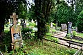 Vaidatoniai cemetery
 -
 Former school
 -
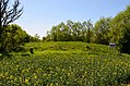 Vaidatoniai hillfort


References
[edit]- ^ "Użupie". Geographical Dictionary of the Kingdom of Poland (in Polish). 12. Warszawa: Kasa im. Józefa Mianowskiego. 1892. p. 874.
- ^ "2011 census". Statistikos Departamentas (Lithuania). Retrieved August 21, 2017.
- ^ Tarybų Lietuvos enciklopedija (in Lithuanian). Vol. 4. Vilnius: Vyriausioji enciklopedijų redakcija. 1988. p. 408.
- ^ "Wojdotany". Geographical Dictionary of the Kingdom of Poland (in Polish). 13. Warszawa: Kasa im. Józefa Mianowskiego. 1893. p. 747.
