Vassouras
Appearance
You can help expand this article with text translated from the corresponding article in Portuguese. (February 2021) Click [show] for important translation instructions.
|
Vassouras | |
|---|---|
| Municipality of Vassouras | |
| Motto: "Mihi maxime debetur Brasiliae incrementum" | |
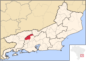
 Location in Rio de Janeiro | |
| Coordinates: 22°24′14″S 43°39′46″W / 22.40389°S 43.66278°W | |
| Country | |
| Region | Southeast |
| State | |
| Founded | 15 January 1833 |
| Government | |
| • Mayor | Severino Ananias Dias Filho |
| Area | |
• Total | 552.438 km2 (213.298 sq mi) |
| Elevation | 434 m (1,424 ft) |
| Population (2020)[1] | |
• Total | 37,083 |
| • Density | 67/km2 (170/sq mi) |
| Time zone | UTC−3 (BRT) |
| HDI (2010) | 0.714 – high[2] |
| Website | vassouras |
Vassouras (Portuguese: [vɐˈsowɾɐs], lit. 'Brooms') is a municipality located in the Brazilian state of Rio de Janeiro. Its population was 37,083 (2020) and its area is 552 km².[3]
Vassouras was the setting for the Bangu neighborhood portrayed in the 1970 Brazilian film My Sweet Orange Tree, as well as the fictional town of "Florença" depicted in the 2001 miniseries Presença de Anita.[4][5]
References
[edit]- ^ IBGE 2020
- ^ "Archived copy" (PDF). United Nations Development Programme (UNDP). Archived from the original (PDF) on July 8, 2014. Retrieved August 1, 2013.
{{cite web}}: CS1 maint: archived copy as title (link) - ^ IBGE - [1]
- ^ "Dica da Folha - Folha Fluminense .: Jornalismo com Responsabilidade Social :". 2016-03-06. Archived from the original on 2016-03-06. Retrieved 2023-08-07.
- ^ Xavier, Nilson. "Presença de Anita". Teledramaturgia (in Brazilian Portuguese). Retrieved 2023-08-07.


