
Vosbučiai
Vosbučiai | |
|---|---|
Village | |
 | |
 Vosbučiai Location in Lithuania  Vosbučiai Vosbučiai (Lithuania) | |
| Coordinates: 55°21′50″N 23°38′31″E / 55.36389°N 23.64194°E | |
| Country | |
| County | |
| Municipality | Kėdainiai district municipality |
| Eldership | Krakės Eldership |
| Population (2011) | |
| • Total | 8 |
| Time zone | UTC+2 (EET) |
| • Summer (DST) | UTC+3 (EEST) |
Vosbučiai (formerly Russian: Возбуты) is a village in Kėdainiai district municipality, in Kaunas County, in central Lithuania. According to the 2011 census, the village had a population of 8 people.[1] It is located 2 kilometres (1.2 mi) from Pajieslys, on the right bank of the Šušvė river, by its tributary the Pečupė mouth. There are the Vosbučiai hillfort and the Vosbučiai outcrop (nature heritage object) in the village. The Lapkalnys-Paliepiai Forest begins west from the village. The Vocbučiai Botanical Zoological Sanctuary is located in Vosbučiai.
Vosbučiai is known since 1593. There was a folwark before the Soviet era.[2]
Demography
[edit]
|
| |||||||||||||||||||||||||||||||||
| Source: 1902, 1923, 1959 & 1970, 1979, 1989, 2001, 2011 | ||||||||||||||||||||||||||||||||||
Images
[edit]-
 Former folwark building
 -
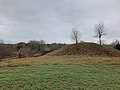 Vosbučiai hillfort
 -
 Vosbučiai hillfort
 -
 Vosbučiai outcrop


References
[edit]- ^ "2011 census". Statistikos Departamentas (Lithuania). Retrieved August 21, 2017.
- ^ "Vosbučiai". Tarybų Lietuvos enciklopedija (in Lithuanian). Vol. 4. Vilnius: Vyriausioji enciklopedijų redakcija. 1988. p. 604.
