
Weißenkirchen in der Wachau
Weißenkirchen in der Wachau | |
|---|---|
 | |
 Coat of arms | |
 Weißenkirchen in der Wachau Location within Austria | |
| Coordinates: 48°24′N 15°28′E / 48.400°N 15.467°E | |
| Country | Austria |
| State | Lower Austria |
| District | Krems-Land |
| Government | |
| • Mayor | Anton Bodenstein |
| Area | |
| • Total | 23.29 km2 (8.99 sq mi) |
| Elevation | 224 m (735 ft) |
| Population (2018-01-01)[2] | |
| • Total | 1,429 |
| • Density | 61/km2 (160/sq mi) |
| Time zone | UTC+1 (CET) |
| • Summer (DST) | UTC+2 (CEST) |
| Postal code | 3610 |
| Area code | 02715 |
| Website | www.weissenkirchen-wachau.at |
Weißenkirchen in der Wachau is a town in the district of Krems-Land in the Austrian state of Lower Austria. The ferry across the Danube here is interesting in that it has no motor or sail: it is powered by rudder set against the river current, anchored to a cable above the river. The ferry carries passengers, bicycles, motorcycles, and automobiles.
Population
[edit]| Year | Pop. | ±% |
|---|---|---|
| 1971 | 1,672 | — |
| 1981 | 1,601 | −4.2% |
| 1991 | 1,563 | −2.4% |
| 2001 | 1,494 | −4.4% |
-
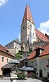 View from the market square to the parish church
 -
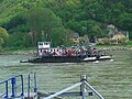 Ferry between Weißenkirchen and St. Lorenz before mooring at Weißenkirchen
 -
 Parish church of Weißenkirchen


References
[edit]- ^ "Dauersiedlungsraum der Gemeinden Politischen Bezirke und Bundesländer - Gebietsstand 1.1.2018". Statistics Austria. Retrieved 10 March 2019.
- ^ "Einwohnerzahl 1.1.2018 nach Gemeinden mit Status, Gebietsstand 1.1.2018". Statistics Austria. Retrieved 9 March 2019.
Wikivoyage has a travel guide for Weißenkirchen in der Wachau.

| International | |
|---|---|
| National | |
This Lower Austria location article is a stub. You can help Wikipedia by expanding it. |