
Wheatley Viaduct
Wheatley Viaduct | |
|---|---|
.jpg) Wheatley Viaduct showing brick layout | |
| Coordinates | 53°44′20″N 1°53′53″W / 53.739°N 1.898°W |
| OS grid reference | SE068270 |
| Crosses | Hebble Brook |
| Locale | Wheatley, Halifax, West Yorkshire, England |
| Characteristics | |
| Total length | 200 yards (180 m) |
| Height | 100 feet (30 m) |
| No. of spans | 10 |
| Rail characteristics | |
| No. of tracks | 2 |
| Track gauge | 4 ft 8+1⁄2 in (1,435 mm) standard gauge |
| History | |
| Opened | 1 August 1890 |
| Closed | 27 June 1960 |
| Location | |
 | |
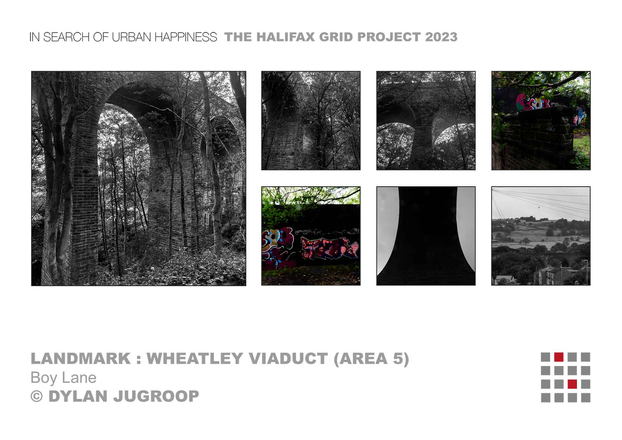
Wheatley Viaduct is a former railway bridge straddling the Hebble Brook on the northern side of Halifax, in West Yorkshire, England. The ten-arch viaduct was built as part of the Halifax High Level Railway that connected with the Queensbury lines complex of the Great Northern Railway between Halifax, Keighley and Bradford. The line was opened in 1890, and closed to all traffic in 1960.
History
[edit]The Queensbury lines were opened to traffic in the late 1870s, and the Halifax High Level Railway was opened in 1890.[1] Originally the intent had been for the line to be extended through Halifax to connect with a proposed Hull and Barnsley Railway station in the centre of Halifax, and as such, the trackbed was built to accommodate two lines.[2][3] The line had two major engineering features, the viaduct, and nearby 810 yards (740 m) Wheatley Tunnel, with the cost of the 3-mile (4.8 km) branch coming in at £300,000 (equivalent to £41,704,000 in 2023).[4] Mapping from 1905 shows the entire branch had double track, but by the late 1940s when it was a freight only branch, just one line was in use across Wheatley Viaduct and through the adjacent tunnel.[5][6]
The viaduct has ten arches, each 50 feet (15 m) wide, and stretches for 200 yards (180 m) at a height of 100 feet (30 m). It has a curve of 23 chains (1,500 ft; 460 m) radius from the south to the east when viewed from above.[7][8][9] In the original plans from 1874, the viaduct was to be 143 yards (131 m) long and 105 feet (32 m) high.[10] The viaduct is constructed of rock-faced stone, ashlar and blue brick. The piers have springer stones facing out into each arch; it is believed that these supported the timber frame during the building phase.[11] Just after the viaduct going east is the 810-yard (740 m) long Wheatley Tunnel.[12] The viaduct is on the level, but has gradients on either side; 1-in-50 to the west, and 1-in-112 to the east leading up to the tunnel.[13]
Whilst the line was closed to passenger trains in 1917, goods continued until final closure in the summer of 1960.[note 1]
In November 2023, the Historical Railways Estate announced that they would be carrying out over £1 million worth of renovations to the viaduct to remove vegetation, replaced water-damaged bricks and to reinforce one of the piers.[15]
Notes
[edit]References
[edit]- ^ a b Joy, David (1984). South and West Yorkshire: the industrial West Riding (2 ed.). Newton Abbot: David Charles. p. 260. ISBN 0-9465-3711-9.
- ^ Bairstow 2015, p. 41.
- ^ Maw, W. H.; Dredge, J., eds. (6 September 1889). "Notes from Yorkshire - the Halifax High Level Railway". Engineering. XLVIII. London: Office for Advertisements and Publication: 278. OCLC 1567895.
- ^ Joy, David (1984). South and West Yorkshire: the industrial West Riding (2 ed.). Newton Abbot: David Charles. p. 132. ISBN 0-9465-3711-9.
- ^ "Georeferenced Maps - Map images - National Library of Scotland". maps.nls.uk. Retrieved 8 November 2023.
Use the slider on the bottom left (named "Change transparency of overlay") to toggle between old mapping and modern-day satellite imagery
- ^ Bairstow 2015, p. 42.
- ^ "Halifax High Level Railway". The Leeds Mercury. No. 16352. Column C. 3 September 1980. p. 8. OCLC 11968069.
- ^ "Wheatley Viaduct". forgottenrelics.org. Retrieved 8 November 2023.
- ^ "Project profile: Wheatley Viaduct - National Highways". nationalhighways.co.uk. 17 October 2023. Retrieved 8 November 2023.
The map shows the layout of the railway with the south on the right hand side of the page, and east towards the top of the page
- ^ "Proposed Huddersfield, Halifax and Bradford Railway". Huddersfield Chronicle. No. 2047. Column C. 28 February 1874. p. 9. OCLC 1326218001.
- ^ "Wheatley Railway Viaduct, Ovenden". wyjs.org.uk. Retrieved 8 November 2023.
- ^ Bairstow 2015, pp. 3, 41.
- ^ Bairstow 2015, p. 43.
- ^ Bairstow 2015, p. 64.
- ^ "Disused Halifax Victorian viaduct to get £1.2m revamp". BBC News. 7 November 2023. Retrieved 7 November 2023.
Sources
[edit]- Bairstow, Martin (2015). The Queesnbury Lines. Farsley: Bairstow. ISBN 978-1-871944-44-0.
External links
[edit]- Image of the viaduct and tunnel portal looking eastwards c. 1910
- Modern day images of the viaduct
- Lost Railways Page about the Halifax High Level Railway
Viaducts in Yorkshire | ||||||||||||||||||||||||
|---|---|---|---|---|---|---|---|---|---|---|---|---|---|---|---|---|---|---|---|---|---|---|---|---|
| Railway viaducts in Yorkshire |
|  | ||||||||||||||||||||||