
Wikipedia:Graphics Lab/Images to improve/request/Emancipation of European Jews map
Please note that this page has been moved to the Graphic Lab request page, and that all queries regarding this image should be directed there.
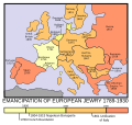
Emancipation of European Jews map
[edit]Image:EmancofJews.gif - Fair use so linked instead of shown.
-
 SVG version by Sbrools

Article(s): Jewish Emancipation
Basically we should convert this unfree GIF map to a free licensed SVG one. Doesn't have to be exactly the same, so long as the result give the same info. --Sherool (talk) 18:52, 14 February 2007 (UTC)
Graphist opinion:
- I created an SVG version, but it doesn't seem to be working correctly. It doesn't load on my browser when I view the image page, it only loads when I click the link. You can view it here. --Sbrools (talk . contribs) 02:36, 21 February 2007 (UTC)
- Hmm yeah, looks like the server side renderer MediaWiki users doesn't like the image for some reason. Opera renders the raw SVG ok (looks good), but no thumbnail... I'm no SVG expert (it I would have done it myself), but is it correct to have
standalone="no"in the header and what doesxlink:href="EmancofJews.gif"do? Does it just link to the gif image? Maybe ask someone at the technical village pump if they can see any obvious problems that prevents MediaWiki to render the thumbnails. --Sherool (talk) 08:39, 23 February 2007 (UTC)- Yes, that seems to have been it. MediaWiki refuses to render images with external references. Removed the reference to the unised GIF image and change the stand alone option to "yes" and wolla. Image renders now :) --Sherool (talk) 12:35, 23 February 2007 (UTC)
- Since Serbia and Bulgaria are shown as independent nations, Greece and Montenegro should be treated the same way. The borders shown on this map are c. 1880, so the map of Greece should include the three blue sections of this map, i.e.; the Peloponnese, the Ionian Islands, and Thessaly. The old border of Montenegro can be seen here. The border of Serbia is a little too far to the south east and the border of Bulgaria a bit too far north. Valentinian T / C 13:14, 25 February 2007 (UTC)
- I've taken the liberty of removing the "done" tag due to the issues mentioned above. Valentinian T / C 22:45, 25 February 2007 (UTC)
- Since Serbia and Bulgaria are shown as independent nations, Greece and Montenegro should be treated the same way. The borders shown on this map are c. 1880, so the map of Greece should include the three blue sections of this map, i.e.; the Peloponnese, the Ionian Islands, and Thessaly. The old border of Montenegro can be seen here. The border of Serbia is a little too far to the south east and the border of Bulgaria a bit too far north. Valentinian T / C 13:14, 25 February 2007 (UTC)
- Yes, that seems to have been it. MediaWiki refuses to render images with external references. Removed the reference to the unised GIF image and change the stand alone option to "yes" and wolla. Image renders now :) --Sherool (talk) 12:35, 23 February 2007 (UTC)
- Hmm yeah, looks like the server side renderer MediaWiki users doesn't like the image for some reason. Opera renders the raw SVG ok (looks good), but no thumbnail... I'm no SVG expert (it I would have done it myself), but is it correct to have