
Wikipedia:Graphics Lab/Map workshop/Archive/Oct 2011
Stale
[edit]UN entry map
[edit]-
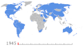 Needs to be updated to include South Sudanese independence

Article(s): United Nations
Request: Please update to include the independence of South Sudan. - Presidentman talk·contribs Random Picture of the Day (Talkback) 14:20, 31 July 2011 (UTC)
- Comment – See Wikipedia:Graphic_Lab/Map_workshop#South Sudan political boundary updates. It's already listed along with 300 other images that need updating. Delusion23 (talk) 16:51, 31 July 2011 (UTC)
Graphist opinion(s):
Flag map Spain
[edit].svg)


Article(s):
Request: Can someone correct several things on this map?
- The flags of the Basque Country and Navarre need to be switched.
- The Canary Islands are missing on the map. Can they be added but to the left of Andalusia.
Graphist opinion(s):
![]() Done Derfel73 (talk) 14:07, 2 August 2011 (UTC)
Done Derfel73 (talk) 14:07, 2 August 2011 (UTC)
England riots
[edit]


Article(s): 2011_London_riots. Sources : London area map
Request: Does someone can propose a map for these recent riots ? Yug (talk) 09:32, 9 August 2011 (UTC)
- Should be doable easily enough. Question is what's wanted: A day-by-day animated GIF, a map with point and/or area markers (to show either daily or overall unrest). I'd imagine the immediate priority is a simple "all to date" one, a map showing all unrest to this point? File:Greater London UK district map (blank).svg is probably better as the base for this. The rioting is not restricted to London now either [1], but affecting other areas - so an England-wide or UK-wide map is probably going to be needed too.--Nilfanion (talk) 09:45, 9 August 2011 (UTC)
Graphist opinion(s):
Nepal Should Not Be Included on Map of Colonized Countries
[edit]
Article(s): [[2]]
Request: In the excellent animated map, "World Empires and Colonies 2007," Nepal is included as a territory colonized by England. Nepal was never colonized. If possible, redrawing the line to follow India's northern border would be useful and accurate. Thanks. 49.244.20.89 (talk) 12:45, 3 October 2011 (UTC)
Graphist opinion(s):
- Nepal isn't highlighted as a colony in the map you have added. Wereldburger758 (talk) 13:16, 3 October 2011 (UTC)
- Nor on any of the other maps in the series, I don't see anything to do here. Kmusser (talk) 14:11, 3 October 2011 (UTC)
Bihar legislative assembly election, 2010
[edit]-
 Attempt (please update/modify)

Article(s): Bihar legislative assembly election, 2010
Request: Could someone please a make a map like this [3] from the one currently on the page? It seems the external one would be copyvio.
- Also, after the polls are announced on November 24 then wed need something like this. Thanks. Lihaas (talk) 13:37, 25 October 2010 (UTC)
Graphist opinion(s):
- Using the SVG that map file was derived from would be better. I find it a little odd that it's not just a clipped region from the SVG file. gringer (talk) 21:39, 25 October 2010 (UTC)
- Actually, on further observation, that map won't do. The administrative boundaries aren't detailed enough for the election boundaries. gringer (talk) 12:44, 26 October 2010 (UTC)
- To demonstrate that, I've extracted out the relevant portion of the locator map and coloured regions as close as possible to the boundaries in the external image (using 4-colour colours plus two more taken from the locator conventions). gringer (talk) 13:12, 26 October 2010 (UTC)
- Actually, on further observation, that map won't do. The administrative boundaries aren't detailed enough for the election boundaries. gringer (talk) 12:44, 26 October 2010 (UTC)
PRC provincial maps
[edit]-
 An example of what I am talking about.
Need to make similar maps for all other province-level divisions. -
 test by yug.
 -
 test with WDB II, by yug.


Article(s): Anything geographic, especially cities, counties, etc
Request: Pushpin/location maps in the mould of the map above, with all of the prefecture-level divisions (directly below the province) and rivers. I have asked NordNordWest on Commons to make them, but there have been only two new maps from him since mid-May, and that we are lacking this many maps (as of this post we have 14 out of 31) is a great embarrassment. To the one answering this query, I am only expecting one map per week, which should be fairly reasonable. Thanks much —Xiaoyu: 聊天 (T) 和 贡献 (C) 15:08, 31 July 2011 (UTC)
Graphist opinion(s):
![]() Request taken by Yug.. Do it in the next few weeks. I found suitable GIS files for administrative borders, with some technical difficulties to solve. Will look for rivers data. Yug (talk) 14:15, 1 August 2011 (UTC)
Request taken by Yug.. Do it in the next few weeks. I found suitable GIS files for administrative borders, with some technical difficulties to solve. Will look for rivers data. Yug (talk) 14:15, 1 August 2011 (UTC)
- Thank you very much! —Xiaoyu: 聊天 (T) 和 贡献 (C) 15:48, 1 August 2011 (UTC)
- NNW, I'm using QGIS to produce similar maps, but I fail to put the administrative layers upon the Naturalearthdata.com physical layers. Do you have some tips to let them match each other ?
- what is your source for rivers ? (mine is too detailed)
- is there a specific projection to tinker ?
- did you simply worked only with the CIESIN / n⁰2 GIS files without mix with naturalearthdata or other ?
- (I'm begging in GIS, please give me some directions) Yug (talk) 13:45, 21 August 2011 (UTC)
- I don't use QGIS so I won't be a help in this, and naturalearth either. I take the rivers from WDB II (but not all of them), the coastline from VMAP Level 0 (better than WDB II) and the administrative boundaries from CIESIN (adjusting them to the rivers). Now and then they have to be corrected a little bit, for this I take a look at the maps you can find in the articles about the provinces. You have to take an equirectangular projection. That's all I'm doing. Of course I would create all maps of Chinese provinces but a) I am working on Norwegian maps, too (lacking of many maps, quite an embarrassment), so it might take some time, and b) a demand like "I am only expecting one map per week, which should be fairly reasonable" is quite ridiculous and will be ignored by me. This is a project made by voluntaries. Otherwise I want to be paid which should be fairly reasonable, too. NNW (talk) 08:18, 22 August 2011 (UTC)
- Thanks NNW. I see for the technical side, for rivers I was indeed suspecting the WDB, which I don't use yet, I will. :) Keep on your projects, I can manage China on my side since I'm interested by this field, and I now found a way to do it. First upload soon.
- Last, NNW, I really agree with your answer: Xiaoyu, we graphists are volunteers, doing high quality maps is technically quite complex and need a bunch of continous hours, generally a full free day or weekend to simply launch a country-project and output the first maps. This aside of our professional and family lives which are still our priorities. We simply can't provide strict timelines: we are common humans mapping in our free time —a scarce resources for all of us—, if no free time, we are mapping 'later'. Yug (talk) 09:27, 22 August 2011 (UTC)
- I don't use QGIS so I won't be a help in this, and naturalearth either. I take the rivers from WDB II (but not all of them), the coastline from VMAP Level 0 (better than WDB II) and the administrative boundaries from CIESIN (adjusting them to the rivers). Now and then they have to be corrected a little bit, for this I take a look at the maps you can find in the articles about the provinces. You have to take an equirectangular projection. That's all I'm doing. Of course I would create all maps of Chinese provinces but a) I am working on Norwegian maps, too (lacking of many maps, quite an embarrassment), so it might take some time, and b) a demand like "I am only expecting one map per week, which should be fairly reasonable" is quite ridiculous and will be ignored by me. This is a project made by voluntaries. Otherwise I want to be paid which should be fairly reasonable, too. NNW (talk) 08:18, 22 August 2011 (UTC)
- NNW, please can you overfly your image to see and answer to my questions. That's there commons:File:China_Shandong_location_map.svg Yug (talk) 06:40, 1 September 2011 (UTC)
- Both VMAP and WDB II are quite old data and have several mistakes. Now and then I check it with satellite images and other maps if there are major mistakes and correct it (e.g. the Three Gorges Dam is missing almost everywhere). This is normal cartographic work, I refuse to name all the different satellite images, atlasses and maps I use for it, it would be to much and won't help any reader. Boundaries and rivers are adjusted manually in the end so they match. Most WP map makers just bring different sources into one file no matter if they match or not. I prefer the classical way of map making which leads to some finishing work but it looks better and is correct cartography. NNW (talk) 07:54, 1 September 2011 (UTC)
- Impressive. More I learn about GIS and map making more I'm surprised by Sting and you, and how professional you are. Very impressive. Thanks for the tips ! Yug (talk) 10:04, 1 September 2011 (UTC)
- Both VMAP and WDB II are quite old data and have several mistakes. Now and then I check it with satellite images and other maps if there are major mistakes and correct it (e.g. the Three Gorges Dam is missing almost everywhere). This is normal cartographic work, I refuse to name all the different satellite images, atlasses and maps I use for it, it would be to much and won't help any reader. Boundaries and rivers are adjusted manually in the end so they match. Most WP map makers just bring different sources into one file no matter if they match or not. I prefer the classical way of map making which leads to some finishing work but it looks better and is correct cartography. NNW (talk) 07:54, 1 September 2011 (UTC)
Norway maps
[edit]-
 Typical blank state locator which needs county locator window.
 -
 County locators to be made by main map
 -
 Desired map design


Article(s):
Request:Hi. I managed to do Template:Location map Norway Sør-Trøndelag successfully in Category:Norway location map templates but everyone I try to do now it keeps shrinking on the paint page when I insert the corner maps so the scale goes off and it isn't svg. I was wondering if you could create new versions of the county maps but with Norway county locator windows. As we don't have any svg type locators at present I was wondering if you could make county locator maps of Norway using File:Norway location map.svg and upload seperately. and then upload new version of the current country maps with these county locator windows in the corner? If you could also create the county locators in the style of the window separately I'll get Template:Infobox Fylke updated to feature them and replace the current maps also♦ Dr. Blofeld 11:01, 30 July 2011 (UTC)
Graphist opinion(s):
- Note: user NNW seems working on the Norway set, see upper section "a) I am working on Norwegian maps, too (lacking of many maps, quite an embarrassment)". Contact him for confirmation. Yug (talk) 09:38, 22 August 2011 (UTC)
Better North American Relations map
[edit]-
 An example of an easily editable map

Article(s): North American relations
Request: Is it possible to make an easily editable map of North America (by "easily editable" I mean possible to copy and paste onto paint, use the paint bucket and colour in a country with ease), like the one above, with country detail? The ones we have usually need to have an .SVG editor and aren't the best quality, and the ones we have on North American relations pages don't look as sophisticated as European ones, again like the one above. 64.229.153.236 (talk) 00:32, 5 August 2011 (UTC)
Graphist opinion(s): That European map should be in SVG format. SVGs are easily editable using a text editor like Notepad. Most of the blank SVG region maps are derived from the blank world map, instructions on how to use which are here. Just pick your color in hex format, and find the corresponding country code to use it on.
But even if you want a PNG format, just go to the page of the blank SVG file, click on the 2000px preview, and save it. Ta-dah, a file you can use in *shudder* Paint. -MissMJ (talk) 02:32, 5 August 2011 (UTC)
- I have taken a look at the map used on the page Canada United-States relations and I can't see what is wrong with that map. Editing a SVG-map is a breeze and a SVG-editor can be downloaded and installed for free (use: Inkscape). Try to use SVG-maps. If you don't want to invest the time into learning it, then come here and ask for the map you want. Wereldburger758 (talk) 07:24, 2 October 2011 (UTC)
Byzantine Maps
[edit]-
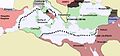 650 AD Byzantine Empire
 -
 600 AD Byzantine Empire
 -
 Sassanid Empire at around 620AD
 -
 Byzantime Empire around 565 AD
 -
 600 AD Byzantine Empire; vector version


Article(s):Byzantine–Sassanid_War_of_602–628
Request: Remake them using some images I have on request since I'm not sure how else to share scanned images. The 600 AD image should be doable with the maps I provided. I'll find some more sources soon for the other maps... But I was hoping I could get this up. DemonicInfluence (talk) 19:19, 25 August 2011 (UTC) I now have a source for a 645AD map.DemonicInfluence (talk) 00:03, 1 September 2011 (UTC)
Graphist opinion(s):
Use as basis the map I used to create this map: [4]. The name must be changed for this map but it is a map about the Byzantine empire. Don't use png-maps. Wereldburger758 (talk) 07:14, 26 August 2011 (UTC)
I have created a vector map for the year 600 and will work on the other two presently. For the 650 CE map are you requesting that all the states be represented rather than just the Byzantine Empire? Derfel73 (talk) 11:15, 1 September 2011 (UTC)
Hi, thanks for the help. It'd be helpful if the 650 AD had more than just Byzantium. I can provide a source if you need it.DemonicInfluence (talk) 21:07, 4 September 2011 (UTC)
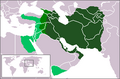
Maps of Byzantine Empire
[edit]-
Byzantine Empire at 650
-
 Byzantine Empire at 717
 -
 Byzantine Empire during Crusades
 -
 Fourth Crusade


Article(s): Byzantine Empire
Request: Requesting that these be converted to SVG. Thanks! SchuminWeb (Talk) 11:13, 15 September 2011 (UTC)
Graphist opinion(s):
Resolved
[edit]SVG map of northern europe which includes Scandinavia, the British Isles, the Faeores, Iceland, and Greenland
[edit]-
 map1
map1 -
 world map blank without borders


Request: I'd like to be able to make a few maps showing the Norse dominion in the 13th century. The dominion included lands in Scandinavia, the British Isles, Iceland, the Faeroe Islands, and Greenland. Map1 (pictured) is perfect, except that it doesn't show Greenland. Can someone come up with an SVG map similar to that which includes Greenland? I don't want borders or anything on the map, just something that I and others can use as a template, to mark different locations and divisions during different eras in history. I messaged the creator of the pictured map, but he's busy with school. I'm hoping that someone here can help.--Brianann MacAmhlaidh (talk) 10:41, 27 September 2011 (UTC)
- Thanks Wereldburger758, that should work.--Brianann MacAmhlaidh (talk) 21:25, 27 September 2011 (UTC)
Graphist opinion(s):
- Answer: What you can use is the map that I have posted here. It is a blank world map without borders. A SVG-map. And you can set a viewport so that only that part of the picture is visible that you want to. If you don't know how to set a viewport, get back to me when you are done. Wereldburger758 (talk) 12:09, 27 September 2011 (UTC)
![]() Done
Done
Diplomatic missions of Barbados
[edit]-
 Diplomatic missions of Barbados (Out of date)
 -
200px (same prob.)
-
500px (same prob.)
-
1000px (same prob.)
-
2000px (same prob.)

Article(s): Diplomatic missions of Barbados
Request: Diplomatic missions of Barbados, the highlighted is missing Cuba, China and Brazil! CaribDigita (talk) 04:17, 28 September 2011 (UTC)
Graphist opinion(s):
![]() Wereldburger758 (talk) 05:30, 29 September 2011 (UTC)
Wereldburger758 (talk) 05:30, 29 September 2011 (UTC)
Portland International Jetport destinations
[edit]Article(s): Portland International Jetport
Request: This article would benefit greatly from having a map of the destinations offered by the various passenger airlines that serve this airport. I tried to create a map using a web site called FlightMemory (you can view my map here), but there are two problems: it won't display the international destinations, only the ones in the continental U.S.; and destinations that are very close together (such as the NYC-area airports and the DC-area airports) end up being on top of each other, as you can see. Any help would be appreciated! –BMRR (talk) 23:43, 16 September 2011 (UTC)
- The destinations are as follows (in no particular order): Toronto (YYZ), Yarmouth (YQI), Baltimore (BWI), Atlanta (ATL), Orlando (MCO), Newark (EWR), Cleveland (CLE), New York (LGA), New York (JFK), Detroit (DTW), Washington DC (IAD), Washington DC (DCA), Chicago (ORD), Charlotte (CLT), and Philadelphia (PHL). Thanks, BMRR (talk) 23:52, 16 September 2011 (UTC)
- Does the picture derived from this website comply with any of the copyrights of Wikimedia Commons? Wereldburger758 (talk) 08:09, 17 September 2011 (UTC)
- I don't know. A few other airport articles on Wikipedia are currently using maps that were created on FlightMemory, so I assumed this was an acceptable practice, but in the end it's a moot point because the map I created isn't usable, due to the problems I mentioned above. Thanks, BMRR (talk) 22:45, 17 September 2011 (UTC)
- What about this: Bwiairportmap?
- That's a very nice map. It would be great if someone (maybe the person who made that map) could create a similar map for the PWM article. –BMRR (talk) 01:29, 19 September 2011 (UTC)
- Definitely should be SVG, though, as that's something that would definitely need to be edited. Pi.1415926535 (talk) 04:09, 19 September 2011 (UTC)
Graphist opinion(s):![]() Request taken by kmusser., completed File:Pwm airport.svg. Kmusser (talk) 16:12, 29 September 2011 (UTC)
Request taken by kmusser., completed File:Pwm airport.svg. Kmusser (talk) 16:12, 29 September 2011 (UTC)
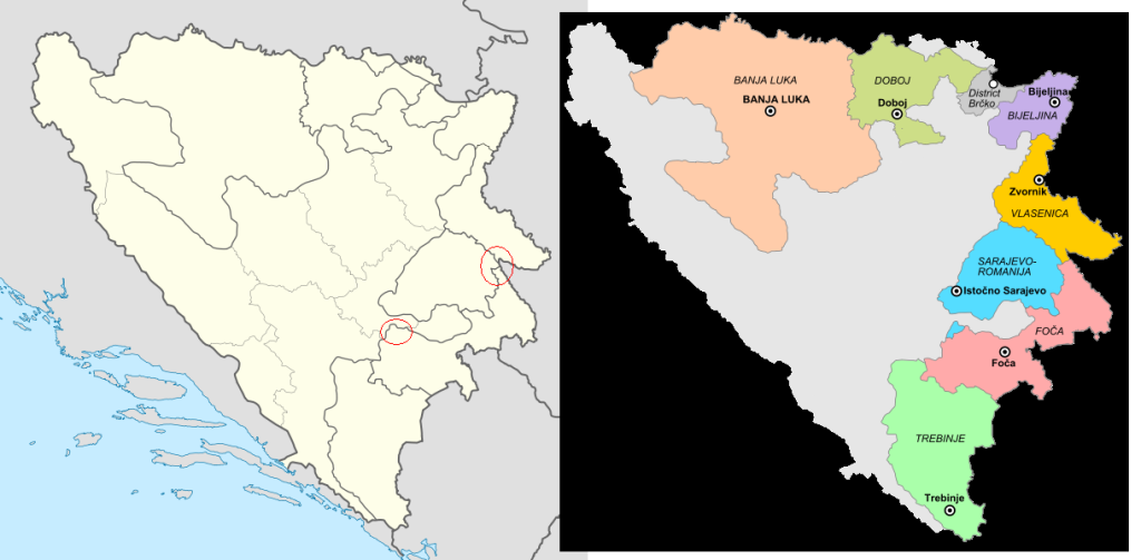
Regions in Republika Srpska
[edit]-
 The map that should been edited. As seen it lacks regions in Republika Srpska, while cantons in Federation of Bosnia and Herzegovina are maped. The regions are as important as the cantons.
 -
 Regions added.


Article(s): Many articles contain this picture
Request: Although the map is good, I would consider that adding borders for regions in Republika Srpska would be welcomed. I'm not profound with maping and I think no one should have something against it (England map has also borders for its regions). Here is a link for the regions (found in article Municipalities of Republika Srpska). Although Brčko District is maped in it, it is an entity of its own, not a part of Republika Srpska. But it is maped to keep a contiunity of the regions. AnelZukic (talk) 03:58, 26 September 2011 (UTC)
Graphist opinion(s):
I can't make heads or tails of your story. Do you want a map of the Srpska Regions in a color different from the rest of the region. Or do you want the border to be outlined with a different color or with a thicker line. You mention England. Can you perhaps give a map of England in which everything is drawn as you want it to be drawn in this map? Please be more clear. Wereldburger758 (talk) 06:49, 26 September 2011 (UTC)
- Sorry for not being clear enough. No, I don't want the regions in different colors, I wanted something like this, but just the lines same as the one used to seperate the cantons, that means not that thick, since the regions are part of Republika Srpska, and now they look like, how to say, more political important, what is not really what I want. Here is what I thought with England (link), but the situation in England isn't that complex as in Bosnia and Herzegovina, which has two two main political entities, FBiH which is divided in ten cantons and RS which is divided in seven regions. So to make it short, I would just like if you would make the recent, by you made, lines a bit less thick, that means as thick as the one used to seperate the cantons within Federation of Bosnia and Herzegovina. And their is a little part of Sarajevo-Romania region (it's seperated from the core region) that you have put in Foča region and the border of Vlasenica region isn't really correct (here, I circled the mistakes link). Sorry for the trouble and thank you. AnelZukic (talk) 02:57, 27 September 2011 (UTC)
- Okay, is this what you want? map
- Or this? map_1
- The second map is perfect, exactly what I wanted. Thank you! :) But just one more question. I would like to upload it as a .svg file, is it possible to convert it? I tried to use some online convertors but didn't had luck... AnelZukic (talk) 17:15, 27 September 2011 (UTC)
- Lol. No, I have made two svg-files and then made png-files of it. Didn't want to upload stuff I wasn't sure of. It should be fine now as it is. Look at my uploaded file in the gallery above. It is a svg-file.
- Sorry for the trouble, thank you a lot :D AnelZukic (talk) 23:55, 1 October 2011 (UTC)
- Lol. No, I have made two svg-files and then made png-files of it. Didn't want to upload stuff I wasn't sure of. It should be fine now as it is. Look at my uploaded file in the gallery above. It is a svg-file.
- The second map is perfect, exactly what I wanted. Thank you! :) But just one more question. I would like to upload it as a .svg file, is it possible to convert it? I tried to use some online convertors but didn't had luck... AnelZukic (talk) 17:15, 27 September 2011 (UTC)
- Or this? map_1
- Okay, is this what you want? map
![]() Request taken by Wereldburger758.. I think I understand what you want.
Request taken by Wereldburger758.. I think I understand what you want.
![]() Done
Done
-
 Map of central San Diego with a pushpin for Point Loma

Article: Point Loma, San Diego
Request: Problem with the location of the pushpin on the pushpin map at this article. Please see the discussion at Talk:Point Loma, San Diego#About that location map.... Point Loma is a peninsula geographically, and is a neighborhood of San Diego politically; the neighborhood is basically contiguous with the peninsula. The map at the top of the page is not a good representation, because it shows the entire Point Loma area with a pushpin located way down at the extreme southernmost tip of the peninsula. Several of us have agreed that the pushpin is misleading because it suggests that only the tip of the peninsula is Point Loma, when in fact the whole peninsula is. At the very least, Point Loma is everything south of a line connecting the river mouth with the bay; many would consider it to be everything south of the river, north of the bay, and east of I-5. That area is too big (on the scale shown) for any pushpin to be accurate, and we are leaning toward simply deleting the pushpin. None of us knows how to do that! Another approach would be to shift to a different map scale which would reduce Point Loma to a size appropriate for a pushpin. Any help or knowledgeable advice appreciated. --MelanieN (talk) 05:12, 4 October 2011 (UTC) MelanieN (talk) 05:30, 4 October 2011 (UTC)
- P.S. Sorry, I can't figure out the name of the map
Graphist opinion(s):
- The pushpin is the result of code and not the result of a drawing. You must go under the hood so to speak. This page gets you under the hood: [5] Wereldburger758 (talk) 07:02, 5 October 2011 (UTC)
Update some maps of Israel Railways
[edit]-
 Israel Railways line map for the near future
 -
 Israel Railways map for the follow-up expansion plan.
 -
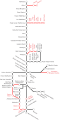 Map with edits (svg)
 -
Second map with edits.


Article(s): Israel Railways
Request: Please mark the line leading from Tel Aviv HaHagana westwards, up to Rishon LeZion West, along with all stations along its route (the circles alng with their labels), from red to black; we also need an other station, between Yoseftal and Rishon LeZion West, called "Komemiyut". Additionally, the Petach Tikva Kiryat Arye station and the Lod Ganei Aviv station need to be changed to black (already done on the second map); and the "Lod" station label seems to be missing on the first map, please add it. The correctness of this request can be confirmed at http://rail.co.il/HE/Stations/Map/Pages/RouteMap.aspx. עוד מישהו Od Mishehu 17:50, 2 October 2011 (UTC)
Graphist opinion(s): Made a SVG-map with Qqad and Inkscape with the changes you requested. Wereldburger758 (talk) 02:40, 6 October 2011 (UTC)
- Except that the line connecting the two Rishon LeZion stations should still be red; and it appears that you've reduced the resolution level of the original image, so that I can't get zoom in to actually read the station names. עוד מישהו Od Mishehu 08:37, 6 October 2011 (UTC)
- I changed the color of the line and enlarged the svg-file. BTW, you can view a svg-file in 200px, 500px, 1000px and 2000px resolution. It is svg-file so you can enlarge it enormously. I made a svg-file so that you can change the file at your will in the future with ease. It is possible to derive a png-file from this picture if you want to. Wereldburger758 (talk) 09:30, 6 October 2011 (UTC)
- Thank you,. first map loks good now. Can you please also blacken the line, and add the station, on the secind map (File:IRplannedmap.png)?
- I don't have the time to do the second map right now. Maybe someone else can take over. Sorry.Wereldburger758 (talk) 12:34, 7 October 2011 (UTC)
- Done it anyway. Wereldburger758 (talk) 08:58, 8 October 2011 (UTC)
- Thank you. עוד מישהו Od Mishehu 06:48, 9 October 2011 (UTC)
- Done it anyway. Wereldburger758 (talk) 08:58, 8 October 2011 (UTC)
- I don't have the time to do the second map right now. Maybe someone else can take over. Sorry.Wereldburger758 (talk) 12:34, 7 October 2011 (UTC)
- Thank you,. first map loks good now. Can you please also blacken the line, and add the station, on the secind map (File:IRplannedmap.png)?
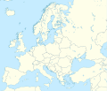
clean a line of a map
[edit]
Article(s): European Parliament election, 1989
Request: Hi, I would paint an electoral map to represent the results of European elections until 1989. To do this, however, I need a map of the model "blank map", which represents the countries borders before 1989, so the color is homogeneous and uniform. This map satisfies that requirement (all other maps not), but I would like the line that represents the "iron curtain" is removed. Can you realize an other map as this, without that line? Thanks.--Pelusu (talk) 21:27, 3 October 2011 (UTC)
Graphist opinion(s):
![]() Request taken by Wereldburger758.
Request taken by Wereldburger758.
- Do you know how to work with SVG-files? If not, get back to me. Wereldburger758 (talk) 05:04, 4 October 2011 (UTC)
Map for Age of consent
[edit]MissMJ (talk) 07:38, 14 August 2011 (UTC)
-

 Done
Done -
 North America
 -
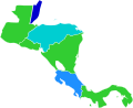 Central America
 -
 Caribbean


We need a new map for the Age of consent article (note: a former request for a map at Ages of consent in North America has been resolved - we now have a new map of the continent of North America there- this request is for the main article Age of consent for a global map).
There are several problems with the existing map (this one-http://commons.wikimedia.org/wiki/File:Age_of_Consent.png).
- 1. several countries have the wrong age . These countries are listed at the talk page at Talk:Age_of_consent#New_map_needed: these are the countries which need their age modified on the map - for example where it says on the talk page "Iceland: 15, not 14" it means that the correct age of consent in Iceland is 15, the new map therefore must show 15.
- 2. several countries have 'puberty' as an age of consent, the existing map doesn't even have a legend color for puberty. The jurisdictions which have 'puberty' for an age of consent are listed on the talk page at Talk:Age_of_consent#New_map_needed
- 3. there are problems with the shades of blue used on the map (9, 12, 13, 14, 15 are barely distinguishable). Several users have complained about this: see File_talk:Age_of_Consent.png#Color_coding.
See the relevant discussions Talk:Age_of_consent#Map, Talk:Age_of_consent#New_map_needed, File_talk:Age_of_Consent.png#Color_coding. — Preceding unsigned comment added by 188.25.161.255 (talk) 13:54, 19 July 2011 (UTC)
- I'll take a look and see what I can do. Pi.1415926535 (talk) 20:13, 19 July 2011 (UTC)
- Sorry, this will be beyond my ability. But what I can contribute is that there's no sense continuing the PNG file; development should be forked to an SVG that's easier to edit. Pi.1415926535 (talk) 21:14, 19 July 2011 (UTC)
- For the user who will accept the task: if desired, I can provide for him/her a list with all world countries and their age of consent which must be shown on the new map (based on Ages of consent in Asia, Ages of consent in North America, Ages of consent in Europe etc...) to make it easier for him/her to create the new map.188.25.163.143 (talk) 21:51, 19 July 2011 (UTC)
- I suggest using File:BlankMap-World6, compact.svg as a base. Pick out the hex values of the necessary number of colors, then go into the SVG code. Use CSS and the ISO 3166-1 alpha-2 code for each country (since every country shaped is named with that code in the blank map) to make it the right color. It wouldn't be terribly difficult, just time consuming to look up all the country codes. If anyone wants to start providing a list of the codes for each age, it would be easier on whoever puts the map together. -MissMJ (talk) 22:16, 19 July 2011 (UTC)
- The only problem with that file, MissMJ, is that at least two countries - the USofA and Mexico - have to be broken up into smaller segments for state laws. Which may be easy for others, but it's what puts this out of my range. Pi.1415926535 (talk) 16:10, 21 July 2011 (UTC)
- Oh blasted USA and its contempt for federal government, making life difficult. *grumblegrumble* Okay, I'll think on how this can be fixed. -MissMJ (talk) 19:59, 21 July 2011 (UTC)
- Mexico's even worse - unorganized state and local rules, and age varies depending on the partner and situation as well. USofA at least keeps it to 50 well-documented state laws. Pi.1415926535 (talk) 21:34, 21 July 2011 (UTC)
- Blech. I'm wondering if it would be better to assign another color to nations where laws vary by state/province/region as a "see these other, more close-up maps for details" and then just make those separately. -MissMJ (talk) 22:31, 21 July 2011 (UTC)
- Yes, this is a good idea. We could simply assign a legend color for "varies by state/province/region/territory" (while using this map - File:BlankMap-World6, compact.svg) and then have detailed maps for the US, Mexico and Australia. 188.25.160.50 (talk) 14:07, 23 July 2011 (UTC)
- Okay if someone can give me a list of all the ages with the corresponding ISO 3166-1 alpha-2 country codes (like, age 9: xx, xx, xx; age 10: xx, xx, xx; and so on [wtf there's countries where 9 and 10 year olds can legally consent?! D: D: D: what is wrong with the world...]), I can make a map using File:BlankMap-World6, compact.svg. -MissMJ (talk) 19:17, 28 July 2011 (UTC)
- Err, I guess some of the info for this moved to my talk page. I'll post the final map here once it's done. -MissMJ (talk) 02:07, 29 July 2011 (UTC)
Alright, it's done! Technically, that North American map needs to be redone in SVG too, using File:North America second level political division 2.svg and File:BlankMap-Caribbean.svg. If someone can provide me with a list of codes for the Caribbean countries and US/Mexican states, with the corresponding age of consent, I can make those as well. -MissMJ (talk) 21:01, 29 July 2011 (UTC)
- Thank you! Great work!188.25.163.68 (talk) 22:14, 29 July 2011 (UTC)
Finished the ones for North/Central America and the Caribbean. -MissMJ (talk) 22:49, 2 August 2011 (UTC)
Rhode Island locator map
[edit]-
 Locator map for Rhode Island
 -


_(extra_close)_(US48).svg)
Article(s): Rhode Island
Request: Where to start...
- The border widths need to be drastically reduced
- The part in the big box should actually match the part in the little box
- Long Island should not be transparent
- The default size of the SVG should be larger
You may just want to redo this one from scratch. Kaldari (talk) 04:14, 6 October 2011 (UTC)
Graphist opinion(s): Looks like this one has already been done. Kmusser (talk) 17:28, 7 October 2011 (UTC)
Serbia map vectorization
[edit]

Article(s): Greater Serbia
Request: Please can someone vectorize this map,thanks... Drax90 (talk) 13:40, 14 October 2011 (UTC)
Graphist opinion(s):
![]() Request taken by Wereldburger758.
Request taken by Wereldburger758.
- HI, you need to include the eastern croatia territories as parts of rebel serb held territories, and you should remove the two smaller enclaves in eastern bosnia,since they were overrun by serb rebels in 1995 Drax90 (talk) 15:49, 15 October 2011 (UTC)
- The smaller enclaves in Eastern Bosnia. Are the enclaves that are pointed out in the picture: http://s938.photobucket.com/albums/ad223/flyingdutchman12/?action=view¤t=Former_Yugoslavia_2006_g_a.png the ones you mean?
- yes,and i forgot o tell you to also remove the third enclave as well based on this map:http://en.wikipedia.org/wiki/File:Srpska_claims_Jan_93.png
- The smaller enclaves in Eastern Bosnia. Are the enclaves that are pointed out in the picture: http://s938.photobucket.com/albums/ad223/flyingdutchman12/?action=view¤t=Former_Yugoslavia_2006_g_a.png the ones you mean?
Were these enclaves in the end controlled by Serb forces? The map http://en.wikipedia.org/wiki/File:Srpska_claims_Jan_93.png shows Srpska CLAIMS. The first map does show the enclaves. It is necessary to be precise. Wereldburger758 (talk) 12:11, 16 October 2011 (UTC)
- yes they were Drax90 (talk) 12:30, 16 October 2011 (UTC)
- Okay, I take your word for it. See new map. Wereldburger758 (talk) 12:39, 16 October 2011 (UTC)
btw. can you colorize other e-yu countries like you did on the last map? Drax90 (talk) 13:07, 16 October 2011 (UTC)
- sorry but you forgot to color the islands in blue and you have crossed into the land area with the adriatic sea and could you erase the borders inside the occupied areas and put them like you did in the first map? Drax90 (talk) 14:55, 17 October 2011 (UTC)
- The reason that I have taken some land from Italy and made sea of it, is because I have acquired some divine powers. With these same powers I can give it back to Italy. Erased the borders of the occupied areas and made the islands blue. Any more requests? Wereldburger758 (talk) 15:38, 17 October 2011 (UTC)
- well,yes you forgot to put the border on the eastern part of croatia,and you could rename it to "Former Yugoslavia 1991-1995",and no more requests,for the time being :) Drax90 (talk) 16:35, 17 October 2011 (UTC)
- border added to eastern part of Croatia, and rename request added to page. Wereldburger758 (talk) 21:47, 17 October 2011 (UTC):Hello again,just wanted to ask you if you could also remove the inner borders within FR Yugoslavia/Serbia-Montenegro? Drax90 (talk) 19:20, 26 October 2011 (UTC)
- Done Wereldburger758 (talk) 11:19, 17 October 2011 (UTC)
-

-
 Winner1st runner-up2nd runner-up3rd runner-up4th runner-up5th runner-up6th runner-upRunners-up 7-18


.svg)
![[4]](https://commons.wikimedia.org/wiki/File:RomanEmpire_117_e.svg)
Article(s): Miss Asia Pacific World 2011
Request: Please made a map same like this image File:Miss Universe 2010 Map.svg to the Miss Asia Pacific World 2011 article, thanks. And because there were two Koreans placed in the Top 19 semi-finalists, just mixed the color for South Korea. DeshintaChandra (talk) 14:37, 24 October 2011 (UTC)
Graphist opinion(s): You might want to give it a shot yourself - editing an SVG map is extremely easy. Try w:Inkscape, for example. Classical geographer (talk) 15:36, 24 October 2011 (UTC)
If I download the inkscape editing software, my computer will error. It hanged many times, and I was unable to edit anything in that software. Please help me to finish this request quickly as soon as possible, thanks. DeshintaChandra (talk) 12:09, 26 October 2011 (UTC)
- Done. Derfel73 (talk) 13:04, 26 October 2011 (UTC)