
Wikipedia:Reference desk/Archives/Miscellaneous/2023 May 20
| Miscellaneous desk | ||
|---|---|---|
| < May 19 | << Apr | May | Jun >> | Current desk > |
| Welcome to the Wikipedia Miscellaneous Reference Desk Archives |
|---|
| The page you are currently viewing is a transcluded archive page. While you can leave answers for any questions shown below, please ask new questions on one of the current reference desk pages. |
May 20[edit]
Why do the southeastern slivers of Alaska fall under Alaska Time?[edit]
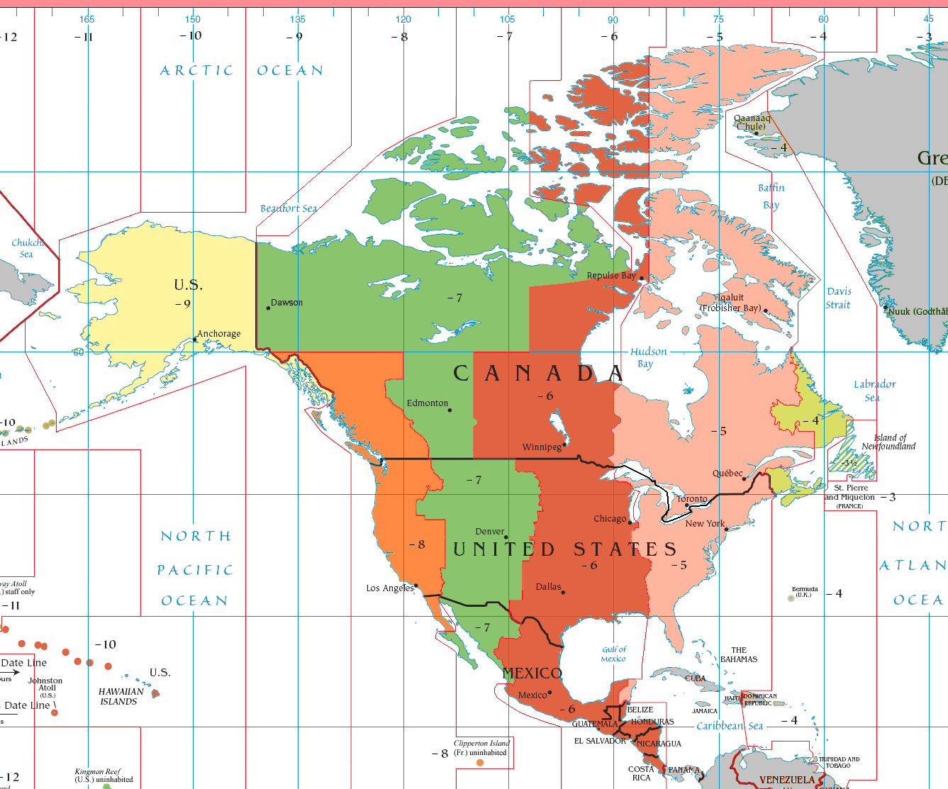
I don't know if it's just the way the map is laid out, but the westernmost parts of British Columbia―which are represented by the Pacific Time Zone―seem to be offset farther west than a good portion of the Alaskan Panhandle in this image. I'm surprised cities like Juneau are considered to belong in UTC−09:00 instead of UTC−08:00. Hmm1994 (talk) 14:46, 20 May 2023 (UTC)
- Maybe the state of Alaska wanted to be in just one time zone. These things are decided by politicians. Note also that the International Date Line bends around the Aleutians, keeping Alaska in the same day; and also bends around the eastern end of Russia, with the same result. ←Baseball Bugs What's up, Doc? carrots→ 17:09, 20 May 2023 (UTC)
- I would have thought it self-evident that time zones would follow state or province boundaries, but I see that North Dakota, South Dakota, Nebraska and Kansas all have two time zones, [1] which must be very inconvenient. Alansplodge (talk) 22:38, 20 May 2023 (UTC)
- Each Australian state and territory sets its own time zone, which applies to the entire state. The only exception I know of is Broken Hill, which uses Central Australian Time rather than Eastern, because it's physically closer to the South Australian state capital, Adelaide, than to its own state capital, Sydney. Also, because this arrangement was put in place back when there was a direct rail link to Adelaide but not to Sydney. -- Jack of Oz [pleasantries] 01:04, 21 May 2023 (UTC)
- In those areas, there are population clusters that lie on the border of two states; it doesn't make sense to make them different time zones. For example, the Rapid City, South Dakota metropolitan area in western South Dakota continues into Wyoming, towns like Sundance, Four Corners, and Newcastle Wyoming are more likely to have business in Rapid City than anywhere in Wyoming. Once you get east of Wall, however, there's fuckall for hundreds of miles. It makes more sense to run the time zone line through cow pastures and oil rigs than it does through the middle of population clusters, so any of the weird jogs the time zone lines make are usually for that reason. --Jayron32 16:25, 22 May 2023 (UTC)
- I would have thought it self-evident that time zones would follow state or province boundaries, but I see that North Dakota, South Dakota, Nebraska and Kansas all have two time zones, [1] which must be very inconvenient. Alansplodge (talk) 22:38, 20 May 2023 (UTC)
Alaska used to be in four time zones, from −8 (Pacific Time) in the southeast (i.e. the Panhandle) to −11 in the west. Some people wanted to have fewer time zones in the state and in 1983 they won out, with the −8 part moving one hour earlier to −9 (then called Yukon Time, now Alaska Time) and the −10 and −11 parts moving one hour later. Or maybe it was more complicated than that.
As for time-zone boundaries following state lines, it is more practical if they are in areas of low population density. In some cases state lines are in areas of high population density. --142.112.220.184 (talk) 04:11, 21 May 2023 (UTC)
- Ah yes, that probably explains it. Those four states have a perfectly straight western border, but the time zone wriggles about like an English country lane. Alansplodge (talk) 11:03, 21 May 2023 (UTC)
- Cities near state lines may have more direct interactions with cities on the other side than they do with those further away in their own state. It would be quite inconvenient to live in one time zone, but work in another. --User:Khajidha (talk) (contributions) 14:38, 21 May 2023 (UTC)
- Tell the people of Tweed Heads (New South Wales) and Coolangatta (Queensland) that. They are so closely connected that the state border runs down the middle of the main street they share. NSW has daylight saving time between October and March, but Queensland does not. For six months of the year, traders on one side of the street are an hour behind/ahead of those on the other. -- Jack of Oz [pleasantries] 21:13, 21 May 2023 (UTC)
- And there are times in the year when there's a two-hour difference between the two Spanish enclaves of Ceuta and Melilla, and Morocco itself. In this case, you can say the two enclaves are turning their backs to Morocco and facing the Spanish mainland, but it's still strange, given the two have a land border with Morocco. Xuxl (talk) 14:40, 22 May 2023 (UTC)
- Tell the people of Tweed Heads (New South Wales) and Coolangatta (Queensland) that. They are so closely connected that the state border runs down the middle of the main street they share. NSW has daylight saving time between October and March, but Queensland does not. For six months of the year, traders on one side of the street are an hour behind/ahead of those on the other. -- Jack of Oz [pleasantries] 21:13, 21 May 2023 (UTC)
- Cities near state lines may have more direct interactions with cities on the other side than they do with those further away in their own state. It would be quite inconvenient to live in one time zone, but work in another. --User:Khajidha (talk) (contributions) 14:38, 21 May 2023 (UTC)