
Wikipedia:WikiProject Maps/Conventions/Exchanges maps
This page provide signaletic conventions for wiki exchange maps. These convention are completing background convention such as location ones and topographic ones. This convention is still to expand especially for flux (human moves, currency moves, sea roads, etc.)
Convention
[edit]| Subject | Colorimetry | Line size |
|---|---|---|
| Freeways/Hways : yellow line on larger red line |
#FFE400
R:255 G:228 B:0 #FF4800
R:255 G:72 B:0 |
3px - 6px (rapport 1:2) |
| Level 1 roads : red line on larger black line |
#FF4800
R:255 G:72 B:0 #000000
R:0 G:0 B:0 |
3px - 4px (rapport 1:1,33) |
| Level 2 roads : simple red line | #FF4800
R:255 G:72 B:0 |
3px |
| Level 3 roads : white line on larger black line |
#FFFFFF
R:255 G:255 B:255 #000000
R:0 G:0 B:0 |
2px - 3px (rapport 1:1,5) |
| Trails, footpaths : small black line (dashed or not) | #000000
R:0 G:0 B:0 |
1,5px |
| Road tunnels : dashed red line | #FF4800
R:255 G:72 B:0 |
3px |
| Rail roads : dashed black line on larger white line |
#000000
R:0 G:0 B:0 #FFFFFF
R:255 G:255 B:255 |
3px |
| Railroad tunnels : dashed black line |
#000000
R:0 G:0 B:0 |
3px |
| Human habitations | #F1C872
R:241 G:200 B:114 | |
| SVG template: Image:Maps_template-en.svg provide further label conventions. | ||
Gallery of examples
[edit]-
 Crau, exchanges roads up on topo background.
 -

-
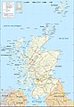 Scotland, exchanges roads + topo-shade + up on Location map background.


See also
[edit]Map conventions and Map Project | |||
|---|---|---|---|
 | Conventions set |  | |
| Drafts | |||
| Others |
| ||