
Wikipedia:WikiProject National Register of Historic Places/NHLsandbox14
Skyline Drive | |
 Marys Rock Tunnel | |
| Area | 3,190 acres[1] |
|---|---|
| NRHP reference No. | ___ |
| Added to NRHP | October 7, 2008 |

- This article refers to the road in Shenandoah National Park in Virginia. For the park itself, see Shenandoah National Park. For other roads named Skyline Drive, see Skyline Drive (disambiguation).
THIS IS SANDBOX TO EXPAND FROM 7/10/2008 VERSION OF Skyline Drive article, adding NHL NOMINATION AND OTHERWISE DEVELOPING.
DRAWINGS AND PICS FROM HABS, TO BE ADDED TO ARTICLE, AND A COMMONS GALLERY OF PICS FROM HABS WOULD REALLY HELP THIS ARTICLE. EXISTING PICS DON'T FEATURE THE ROAD, ITS OVERLOOKS, ROCK WALLS, ETC. HABS PICS AVAILABLE HERE
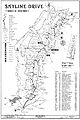
Skyline Drive is a 105 mile (169 km) road that runs the entire length of the National Park Service's Shenandoah National Park in the Blue Ridge Mountains of Virginia, generally along the ridge of the mountains. The scenic drive is particularly popular in the fall when the leaves are changing colors. Annually, over two million people visit the Skyline Drive, which has been designated a National Scenic Byway. It was designated a U.S. National Historic Landmark on [[___]], 2008.[1]
Entry
[edit]Major entry points to Skyline Drive are:
- Front Royal, Virginia (U.S. Highway 340), the northern terminus
- Thornton Gap (U.S. Highway 211)
- Swift Run Gap (U.S. Highway 33)
- Rockfish Gap (Interstate 64, U.S. Highway 250), the southern terminus.
As of June 2007, the entry fee for all vehicles is $15 for a single car, and $10 for motorcycles.Passes, which are valid for unlimited entries within a seven-day period, are issued. Payment may be made with cash, credit, or debit cards. A year-long pass can be purchased for $30.(A Season Pass will admit 2 motorcycles)Since user fees are charged at entry points along the Skyline Drive, the Drive is sometimes mistaken as a toll road. The fee, however, is not a toll charged to drive on the road, but rather to enter, and enjoy, the park. A $15.00 pass is valid for up to seven days (as opposed to charging by the mile, or by the day, as toll roads do).
Mileposts
[edit]On the west side (right when travelling from north to south) of the drive mileposts are present. They are numbered from 0.0 to 105 (north to south). These are the reference points to directions in the drive.[2]
Driving precautions
[edit]
The speed limit is 35 miles per hour (60 km/h). The road is very tortuous and hence such a limit is enforced. One might see stopped vehicles in the road either enjoying the wildlife or just turning to stop at an overlook. Bicycles, vehicles and pedestrians share the road. This requires extra precaution. There are also many deer, bear and other wildlife crossing the road, which can appear with no prior warning. The speed limit within the park is also strictly enforced by park police.
Experience
[edit]As the name suggests, the road takes a winding path along the mountaintops of the Blue Ridge Mountains east of the Shenandoah River. There are nearly seventy five overlooks throughout the drive. Some of the most spectacular views of the valley can be seen. During the drive (especially in early morning and late evening) wildlife can be seen on the road. Interestingly, Shenandoah National Park has one of the densest populations of black bears documented within the U.S., although these bears stay deep in the forest.[3]

Apart from the drive, one can hike and even camp. There are numerous trails throughout, including a portion of the Appalachian Trail, which follows the road's path. Biking and horseback riding are other recreational activities which are allowed on the road. There are also visitors centers, cabins for rent, and even restaurants (the one at the Skyland Lodge gives diners a spectacular vista of the valley south of Luray).
There is a tunnel named the "Marys Rock Tunnel" at mile 31 of the drive. The clearance is 12'8" (3.8 m). It is 670 feet (203 m) long.[4]
At Rockfish Gap, the Blue Ridge Parkway begins, and continues a similar path along ridge tops through Virginia and into North Carolina, terminating at Great Smoky Mountains National Park. Though the land immediately around the parkway is protected by the National Park Service, much of the parkway goes near private land, but it is, nonetheless, quite rustic and charming.
History
[edit]- Further information:History of Shenandoah National Park
Begun in 1931 as an emergency employment program using National Park Serive road funding and Bureau of Public Roads staff for design, construction of the Skyline Drive was expanded under the Roosevelt Administration's work programs during the Great Depression. The construction was both difficult and dangerous. Huge cuts were made into the sides of knolls and peaks to allow for a road wide enough to handle traffic. The work began in 1931, and the final section (from Swift Run Gap to Rockfish Gap) was completed and opened in 1939.
-
 North district, Skyline Drive
 -
 Central district, Skyline Drive
 -
 South district, Skyline Drive


References
[edit]- ^ a b Linda Flint McClelland and Reed L. Engle (May 1, 2008). "National Historic Landmark Nomination: Skyline Drive Historic District" (PDF). National Park Service.
- ^ Shenandoah National Park - Driving Skyline Drive (U.S. National Park Service)
- ^ Shenandoah National Park - Mammals (U.S. National Park Service)
- ^ Shenandoah NP: Shenandoah Stories
See also
[edit]- List of National Historic Landmarks in Virginia
- Appalachian Trail
- Big Meadows
- Skyland Resort
- Rapidan Camp
- Lost counties, cities and towns of Virginia
External links
[edit]- Historic American Engineering Record (HAER) No. VA-119, "Skyline Drive, From Front Royal, VA to Rockfish Gap, VA, Luray vicinity, Page County, VA", 117 photos, 18 measured drawings, 11 photo caption pages
- Skyline Drive Historic District
- National Park Service, Shenandoah National Park, official website
- Mile-by-Mile website, detailed information and many photographs
- The Ground Beneath Our Feet: Building the Skyline Drive and Shenandoah National Park
- A Skyline Drive webpage a non-commercial website with lots of history, information, and photos
[[Category:National Scenic Byways|Skyline Drive]]
[[Category:Augusta County, Virginia]]
[[Category:Albemarle County, Virginia]]
[[Category:Rockingham County, Virginia]]
[[Category:Greene County, Virginia]]
[[Category:Page County, Virginia]]
[[Category:Madison County, Virginia]]
[[Category:Rappahannock County, Virginia]]
[[Category:Warren County, Virginia]]
[[Category:Shenandoah National Park]]
[[Category:Historic American Engineering Record in Virginia]]

[[nl:Skyline Drive]]
[[pl:Skyline Drive]]