
Wikipedia:WikiProject U.S. Roads/Maps task force/Requests/Archive 12
| This page is an archive. Do not edit the contents of this page. Please direct any additional comments to the current main page. |
- Class:
 Stub-Class article
 - Action required: New map
- Status: New request
- KML: Yes
- Comments: I need a map for the KML file I created for this article. Thanks! Paul Webb (PaulWebbtheTechExpert) (talk) 03:56, 24 January 2021 (UTC)
- {{Done}} Paul Webb (PaulWebbtheTechExpert) (talk) 16:28, 27 January 2021 (UTC)
- Class:
 Start-Class article
 - Action required: New map
- Status: New request
- KML: No
- Comments: I was wondering if we could create a map for the former proposed Garden Parkway similar to that done for Interstate 895 (Rhode Island–Massachusetts)? Here is a map of the once proposed toll road. Thank you! --WashuOtaku (talk) 16:53, 26 January 2021 (UTC)
- {{done}} –Fredddie™ 06:08, 29 January 2021 (UTC)
- Thank you! --WashuOtaku (talk) 15:10, 29 January 2021 (UTC)
- Class: Start-Class article
- Action required: Correction to existing map
- Status: New request
- KML: [1]
- Comments: Hello! Please change the color of the segment between FM 1488 east of Magnolia and FM 1774 north of Todd Mission to red to reflect the opening of this segment. Thanks! TextClick (talk) 22:30, 31 March 2021 (UTC)
- Class:
 C-Class article
 - Action required: Correction to existing map and KML file
- Status: New request
- KML: Yes
- Comments: Hi! Please update the map and KML file to include the final segment of the highway from Sand Hollow Road to State Route 9. Thanks! TextClick (talk) 05:33, 21 May 2021 (UTC)
- Class: Start-Class article
- Action required: Correction to existing map and KML files
- Status: New request
- KML: Yes
- Comments: Hi! Please modify the map and KML files to follow the newer alignment of US 175 between I-45 and TX 310 opened to traffic in 2020. Thank you! TextClick (talk) 05:21, 30 July 2021 (UTC)
- Class: Start-Class article
- Action required: New map, correction to existing KML file
- Status: New request
- KML: Yes
- Comments: Hi! Please create an updated interactive map and update the existing KML file to accurately depict the full route between I-45 in Hutchins and I-45 in Dallas. Thank you! TextClick (talk) 07:08, 30 July 2021 (UTC)
- Class: C-Class article
- Action required: Correction to existing map and KML file
- Status: New request
- KML: Yes
- Comments: Hi! Please change the color of the easternmost 5.8 mile section from blue to red to reflect the opening of that section on February 22, 2021. Thank you! TextClick (talk) 07:12, 30 July 2021 (UTC)
- Class: Start-Class article
- Action required: New map, new KML
- Status: New request
- KML: No
- Comments: Hi! Please create a map and KML file for this article. If possible, please also depict the future sections in a different color. Thank you! TextClick (talk) 04:34, 31 July 2021 (UTC)
- {{done}} KML of open section and map of open+future corridors added —Mr. Matté (Talk/Contrib) 13:35, 31 July 2021 (UTC)
- Class: C-Class article
- Action required: New map, new KML
- Status: New request
- KML: No
- Comments: Hello! Please create a new interactive map and KML file for this page. Thank you! TextClick (talk) 03:31, 5 September 2021 (UTC)
- Class: C-Class article
- Action required: New map, new KML
- Status: New request
- KML: No
- Comments: Hello! Please create a new interactive map and KML file for this page. Thank you! TextClick (talk) 03:31, 5 September 2021 (UTC)
- Class: Start-Class article
- Action required: New map, new KML
- Status: New request
- KML: No
- Comments: Hello! Please create a new map and KML for this article. Thank you! TextClick (talk) 07:03, 8 September 2021 (UTC)
- {{Done}}{{User:ClueBot III/ArchiveNow}} -420Traveler (talk) 06:03, 11 September 2021 (UTC)
- Class: C-Class article
- Action required: Correction to existing map and KML
- Status: New request
- KML: Yes
- Comments: Hi! Please update the map and KML files for I-49's main page and pages for Arkansas and Missouri in order to reflect the opening of the Bella Vista Bypass. Thanks! TextClick (talk) 03:45, 3 October 2021 (UTC)
- {{done}} All KMLs and interactive map files revised —Mr. Matté (Talk/Contrib) 03:36, 5 October 2021 (UTC)
- Class:
 B-Class article
 - Action required: Correction to existing map
- Status: New request
- KML: Yes
- Comments: Map shows NY 226 ending at NY 415, needs to be extended to NY 17/ I-86. 420Traveler (talk) 14:52, 31 October 2021 (UTC)
{{User:ClueBot III/ArchiveNow}}
Interstate 265 (Tennessee)
- Class: C-Class article
- Action required: Map not showing up
- Status: New request
- KML: Yes Template:Attached KML/Interstate 265 (Tennessee)
- Comments: I created the KML file and inserted it into Wikipedia, however, this error keeps popping up: "<mapframe>: Couldn't parse JSON: Syntax error". I don't know what's wrong with it. Paul Webb (PaulWebbtheTechExpert) (talk) 05:05, 5 November 2021 (UTC)
- @PaulWebbtheTechExpert: you created the KML, but the map frame doesn't use the KML file. It uses a GeoJSON file, which you didn't create. I've converted the KML to GeoJSON at Wikipedia:Map data/Wikipedia KML/Interstate 265 (Tennessee), and now the map frame will work once the server caches it. Marking this as {{done}}. Imzadi 1979 → 05:17, 5 November 2021 (UTC)
- Class: B-Class article
- Action required: Needs an interactive map
- Status: New request
- KML:
- Comments: 150.250.5.31 (talk) 03:51, 6 November 2021 (UTC)
- {{done}} pending the server caching the map. Imzadi 1979 → 04:25, 6 November 2021 (UTC)
- Class:
 Good article
 - Action required: Interactive map
- Status: New request
- KML:
- Comments: 150.250.5.20 (talk) 14:04, 6 November 2021 (UTC)
{{done}} New map should appear shortly. —Mr. Matté (Talk/Contrib) 23:09, 6 November 2021 (UTC)
- Class: B-Class article
- Action required: Needs interactive map
- Status: New request
- KML:
- Comments: 150.250.5.31 (talk) 03:54, 7 November 2021 (UTC)
- Class: Good article
- Action required: Interactive map
- Status: New request
- KML: Yes [2]
- Comments: 150.250.5.20 (talk) 04:55, 7 November 2021 (UTC)
- Class: Good article
- Action required: Interactive map
- Status: New request
- KML:Yes (https://en.wikipedia.org/w/index.php?title=Template:Attached_KML/U.S._Route_206&action=raw)
- Comments: 150.250.5.20 (talk) 13:32, 8 November 2021 (UTC)
{{done}} Map & KML revised —Mr. Matté (Talk/Contrib) 18:08, 8 November 2021 (UTC)
- Class: Start-Class article
- Action required: Creation of new map
- Status: New request
- KML:
Yesdated 2012 - Comments: Opportunity Corridor ribbon-cutting was held recently, SR 10 signage has gone up at East 55th Street for example. Cards84664 02:28, 4 November 2021 (UTC)
- Can you update the KML? I can't see anything on ODOT's website that shows the new route. –Fredddie™ 04:16, 7 November 2021 (UTC)
- I've started an update of the KML file (cleaning up the existing portion of SR 10 mostly) and have general linework ready for the new portion of the road. I don't know however if the two segments will be connected, and whether signage will appear along what would be the concurrencies with US 422, I-77, etc. The 2013 public hearing PDF does show a continuous route for SR 10 but maybe this can be verified in the field. —Mr. Matté (Talk/Contrib) 18:08, 8 November 2021 (UTC)
- Can you update the KML? I can't see anything on ODOT's website that shows the new route. –Fredddie™ 04:16, 7 November 2021 (UTC)


{{done}} —Mr. Matté (Talk/Contrib) 04:25, 9 November 2021 (UTC)
- Class: Start-Class article
- Action required: Fix KML and map
- Status: New request
- KML: Yes, Template:Attached KML/U.S. Route 41 in Tennessee, Wikipedia:Map data/Wikipedia KML/U.S. Route 41 in Tennessee
- Comments: I converted the KML file to a map file and added it to the article, however, an error message has appeared saying “The time allocated for running scripts has expired.”. I believe the the KML and map file is simply too large to display correctly on the article, causing the error. I don’t know how to shorten it down, but I’m sure someone does. Thank you! Paul Webb (PaulWebbtheTechExpert) (talk) 16:31, 7 November 2021 (UTC)
- Class: Good article
- Action required: Interactive map
- Status: New request
- KML: Yes (https://en.wikipedia.org/w/index.php?title=Template:Attached_KML/U.S._Route_1_in_New_Jersey&action=raw )
- Comments: 150.250.5.20 (talk) 18:50, 8 November 2021 (UTC)
This seems to be done --Guerillero Parlez Moi 00:21, 9 November 2021 (UTC)
- Class: Good article
- Action required: Interactive map
- Status: New request
- KML: Yes (https://en.wikipedia.org/w/index.php?title=Template:Attached_KML/U.S._Route_130&action=raw)
- Comments: 150.250.5.31 (talk) 01:18, 9 November 2021 (UTC)
- Class: Good article
- Action required: Interactive map
- Status: New request
- KML: Yes (https://en.wikipedia.org/w/index.php?title=Template:Attached_KML/Skyline_Drive&action=raw)
- Comments: 150.250.5.31 (talk) 02:26, 9 November 2021 (UTC)
- Class: B-Class article
- Action required: Interactive map
- Status: New request
- KML: Yes (https://en.wikipedia.org/w/index.php?title=Template:Attached_KML/Pennsylvania_Route_611&action=raw)
- Comments: 150.250.5.31 (talk) 02:28, 11 November 2021 (UTC)
- Question: Before I mark it done, is there any particular rhyme or reason behind your requests for these Northeast/Mid-Atlantic interactive maps? Interactive maps are not required for good/featured article status (unless the original "hardcopy" map is incorrect/out-of-date) and there's plenty of articles that currently have no maps at all. —Mr. Matté (Talk/Contrib) 14:00, 11 November 2021 (UTC)
- I just wanted all highways in New Jersey to get back their interactive maps since they used to have them before the system crashed and they all disappeared. I know you and other editors put back 98% of them, and I just wanted that to bump that up to 100%. Then my quest for interactive maps sort of went beyond NJ as I was exploring other pages, like this one. But I think I got all the maps I wanted so I will probably not be requesting anymore map upgrades in the near future. 150.250.5.20 (talk) 14:47, 11 November 2021 (UTC)
- Class: B-Class article
- Action required: Map won’t show
- Status: New request
- KML: https://en.wikipedia.org/w/index.php?title=Template:Attached_KML/Pennsylvania_Route_896&action=raw
- Comments: Needforspeed888 (talk) 06:33, 21 December 2021 (UTC)
- Class: C-Class article
- Action required: Mainline of PA 8 not showing
- Status: New request
- KML: https://en.wikipedia.org/w/index.php?title=Template:Attached_KML/Pennsylvania_Route_8&action=raw
- Comments: Needforspeed888 (talk) 18:32, 21 December 2021 (UTC)
- Class: B-Class article
- Action required: Map broken
- Status: New request
- KML: https://en.wikipedia.org/w/index.php?title=Template:Attached_KML/U.S._Route_13_in_Pennsylvania&action=raw
- Comments: Needforspeed888 (talk) 19:10, 22 December 2021 (UTC)
- Class: C-Class article
- Action required: Correction to existing map and KML
- Status: New request
- KML: Yes
- Comments: Hello! Please tweak the map and KML file to reflect the opening of a five-mile segment of I-69 from SR 39 to SR 44 in Martinsville. Thanks! 47.28.76.45 (talk) 05:57, 25 December 2021 (UTC)
- This looks to have been {{Done}}. Thank you to whoever did this! 47.28.76.45 (talk) 22:33, 10 January 2022 (UTC)
- Class: C-Class article
- Action required: Correction to existing map
- Status: New request
- KML: Yes
- Comments: The current map does not show the extension from I-40 south to US-64. 420Traveler (talk) 15:03, 11 January 2022 (UTC)
- Class: B-Class article
- Action required: Map broken
- Status: New request
- KML: https://en.wikipedia.org/w/index.php?title=Template:Attached_KML/New_York_State_Route_89&action=raw
- Comments: Needforspeed888 (talk) 01:37, 13 February 2022 (UTC)
- Class: C-Class article
- Action required: Addition of US 202 Cortlandt Alternate in blue
- Status: New request
- KML: Yes. but only for the main route https://wma.wmcloud.org/iframe.html?41.252855_-73.848735_0_0_en_8_en_41.253662109375_286.14990234375&globe=Earth&page=U.S.%20Route%20202%20in%20New%20York&lang=en
- Comments: The U.S. Route 6 in New York map contains the Cortlandt Alternate Route and the presence of New York State Route 6N. US 202 does not contain the latter route. Additionally, the version for US 202 Alternate would provide a closer and more detailed view than the one for US Alternate 6. -----User:DanTD (talk) 14:01, 18 May 2022 (UTC)
National U.S. Highway articles missing KML and maps
I'm going through the national U.S. Highway articles and making sure that the articles' mapframe maps are hosted on Commons. It's a ridiculous improvement in page performance versus using the raw data method, plus other wikis can use it. Anyway, none of these articles have KML, much less GeoJSON data.
- U.S. Route 219
- U.S. Route 231
- U.S. Route 277
- U.S. Route 285
- U.S. Route 287
- U.S. Route 377
- U.S. Route 380
- U.S. Route 411
- U.S. Route 412
- U.S. Route 431
- U.S. Route 441
- U.S. Route 460
These articles have a KML, but they're massive and they need to be optimized with the Douglas-Peucker algorithm before converting to GeoJSON
These articles just need a mapframe map
These articles have a Commons map, but they're massive and they need to be optimized
I will add more, as I find them but I am working backwards and I am through US 270. If you complete a map, just sign behind it as to not trip the archive bot. –Fredddie™ 09:31, 20 February 2022 (UTC)
- {{Done}} All of the articles you mentioned above have mapframe maps now. I will try to work on other U.S. Road articles that don't have a mapframe maps. ~ Sandy14156 (Talk ✉️) 23:04, 10 June 2022 (UTC)
- Class: Good article
- Action required: Correction to existing map
- Status: New request
- KML: No
- Comments: BrianHagan (talk) 00:21, 27 June 2022 (UTC) The description below this map says "K-23 in red, K-23 Alternate in blue, K-23 Spur in green" but there is only a red line.
- {{not done}} The blue and green lines are present in the interactive map around Grainfield (near I-70). It's just that they are so short relative to the rest of the route and they really aren't recognizable from the default view. —Mr. Matté (Talk/Contrib) 00:41, 27 June 2022 (UTC)
- Class: Start-Class article
- Action required: Correction to an existing map
- Status: New request
- KML: Yes https://en.wikipedia.org/wiki/Template:Attached_KML/Montana_Highway_16
- Comments: BrianHagan (talk) 23:44, 26 June 2022 (UTC) The map is missing the leg of Highway 16 between Sidney and Glendive.
- Class: B-Class article
- Action required: Correction to existing map
- Status: New request
- KML: Yes https://en.wikipedia.org/w/index.php?title=Template:Attached_KML/Interstate_795_(North_Carolina)&action=raw
- Comments: It Currently does not show the future Extension of I-795 from Goldsboro to I-40 south of FaisonQutlooker (talk) 22:56, 7 January 2022 (UTC)
@Qutlook: you didn't follow the directions on the page (nevermind that the entire page was overwritten) so your request was reverted. Is this what you were requesting?
Yes, sorry for overwriting the page I made sure to follow it but I guess I wasn't looking and overwrote the page Qutlooker (talk) 18:26, 14 January 2022 (UTC)
{{Done}} OrdinaryJosh (talk) 00:31, 3 July 2022 (UTC)
- Class: C-Class article
- Action required: New KML
- Status: New request
- KML: No
- Comments: Hello! There is apparently no KML file for this highway. Please make a new one. Thank you! OrdinaryJosh (talk) 20:48, 3 July 2022 (UTC)
- Class: Stub-Class article
- Action required: Correction to existing map
- Status: New request
- KML: Not sure
- Comments: BrianHagan (talk) 02:48, 5 July 2022 (UTC) The map on the page does not show anything. There is an entry on the bottom right of the page that says KML file - when I click it , it downloads an index that, if I open in Notepad, says "North Dakota Highway 5.kml" in it. I don't know if this helps.
- Class: C-Class article
- Action required: Addition of a "Future" section to the map
- Status: New request
- KML: Yes
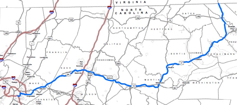
- Comments: The current map does not include the future part of the route like other articles in the same situation (Interstate 587 or 540). Here is the route map in NC and the full route map in both NC and VA. Thanks for your help and have a great day! DiscoA340 (talk) 01:50, 4 August 2022 (UTC)
- Class: C-Class article
- Action required: Update Map
- Status: New request
- KML: Yes
- Comments: The current map does not show the sections currently under construction. Here is the project on the NCDOT Webpage and then the actual map also from the NCDOT (STIP Plan.) Thank you and have a good day! DiscoA340 (talk) 21:57, 6 October 2022 (UTC)
- Class: C-Class article
- Action required: Add future route section to maps
- Status: New request
- KML: I-73, I-74
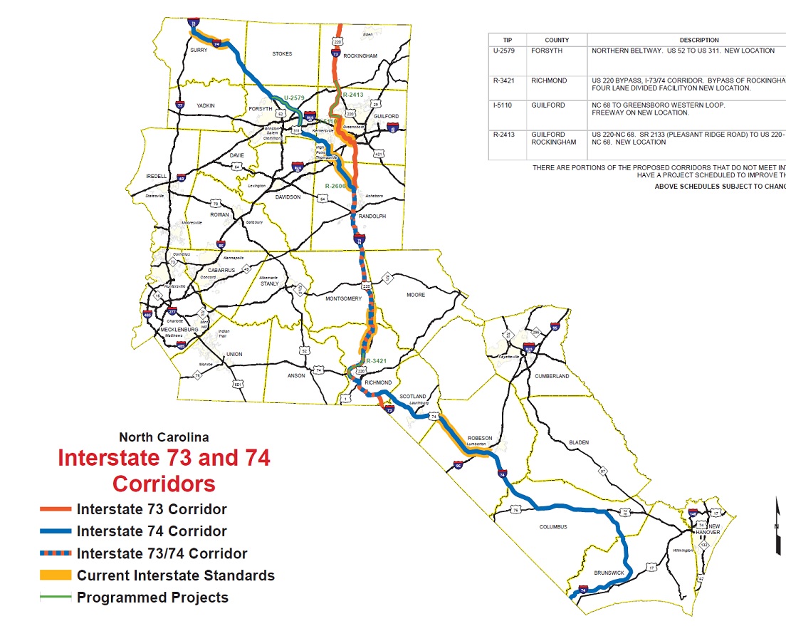
- Comments: The current maps lack the future sections for both routes. For I-74, most of the future route is known except for the section past Bolton, NC. The current plan seems like it will turn onto NC-211 and then onto US-17 near supply and follow that route until the Carolina Bays Parkway where it will end near Socastee, SC. For I-73, there are only two unbuilt sections in the state. Here are a few maps I found for both routes. I-74 and I-73, I-74 past Bolton, I-73 near Rockingham. Thank you and have a good day! DiscoA340 (talk) 04:20, 8 September 2022 (UTC)
- Class:
 List
List - Action required: Update/fix current map
- Status: New request
- KML: Yes (Interactive map)
- Comments: Hello! Please make a new interactive Commons map and KML file for this article. I'm not sure if just including the current segments would be sufficient, or if we could include future segments. The latter would open a whole can of worms but it would be nice. Thanks! OrdinaryJosh (talk) 05:26, 8 September 2022 (UTC)
 Doing... See article's talk page for progress. –Fredddie™ 02:00, 7 October 2022 (UTC)
- Apologies if this may be a bit troublesome, but since both are technically part of this request, would it also be possible to update the map and KML file for Interstate 285 (North Carolina) and just the KML file for Interstate 795 (North Carolina) to account for the future sections for both highways? –OrdinaryJosh (talk) 07:53, 8 October 2022 (UTC)
- @OrdinaryJosh I believe the KML map already includes the future segments for I-795. For I-285, I was able to find this map which shows the extension leading to the future northern terminus of I-274 via US 52. This map seems to be backed up by the information in Interstate 285 (North_Carolina)#Future. Hope this helps. DiscoA340 (talk) 22:03, 9 October 2022 (UTC)
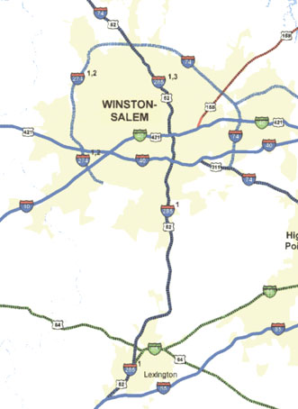
- Just as a notice since the maps for both I-73 and I-74 were both marked done in the now archived section above this one, there is a slight mistake with the I-74 map. In the Winston-Salem area, I-74/the Winston-Salem Northern Beltway is actually expected to continue south of I-40 to directly tie into the current segment of I-74 at a new interchange slightly east of the current I-40 interchange. The segment between these two interchanges is expected to be redesignated as NC 192. Here's a map which shows it running south past I-40 and one which shows the new interchange with current I-74. –OrdinaryJosh (talk) 03:03, 10 October 2022 (UTC)
- Apologies if this may be a bit troublesome, but since both are technically part of this request, would it also be possible to update the map and KML file for Interstate 285 (North Carolina) and just the KML file for Interstate 795 (North Carolina) to account for the future sections for both highways? –OrdinaryJosh (talk) 07:53, 8 October 2022 (UTC)
- Class:
 Future
 - Action required: Update current map
- Status: New request
- KML: Yes
- Comments: Hello! Please help create a mapframe map using Commons map and an accompanying KML file to boot. Thank you! -OrdinaryJosh (talk) 01:03, 17 July 2022 (UTC)
- Can you provide a link to something that will show where the highway will run? –Fredddie™ 16:18, 19 July 2022 (UTC)
- Here are the project maps: Shelby Bypass. --WashuOtaku (talk) 17:00, 19 July 2022 (UTC)
- I don't know if this request has been done or not, but I found this map and the project on the STIP interactive map. DiscoA340 (talk) 04:26, 8 September 2022 (UTC)
- Here are the project maps: Shelby Bypass. --WashuOtaku (talk) 17:00, 19 July 2022 (UTC)
- Can you provide a link to something that will show where the highway will run? –Fredddie™ 16:18, 19 July 2022 (UTC)
- {{Done}} by Mr. Matté. --OrdinaryJosh (talk) 06:32, 22 October 2022 (UTC)
- Class: C-Class article
- Action required: Update map
- Status: New request
- KML: Yes
- Comments: According to this map I-285 will extend to the future northern terminus of I-274 via US 52. This map seems to be backed up by the information in Interstate 285 (North_Carolina)#Future. DiscoA340 (talk) 14:49, 21 October 2022 (UTC)
- Class: C-Class article
- Action required: Correction to existing map
- Status: New request
- KML: Yes (KML File) (Data Map)
- Comments: There is a slight mistake with the I-74 map. In the Winston-Salem area, I-74/the Winston-Salem Northern Beltway is actually expected to continue south of I-40 to directly tie into the current segment of I-74 at a new interchange slightly east of the current I-40 interchange. The segment between these two interchanges is expected to be redesignated as NC 192. Here's a map which shows it running south past I-40 and one which shows the new interchange with current I-74. - OrdinaryJosh (talk) 03:03, 10 October 2022 (UTC)
- Due to the recent opening of a new segment of the Winston-Salem Northern Beltway, please now update the segment between NC 66 (University Parkway) and US 311 (New Walkertown Road) to blue for the I-74 page, and additionally to red on the dedicated beltway page. Thank you! --OrdinaryJosh (talk) 06:43, 13 November 2022 (UTC)
- Class: List
- Action required: Correction to existing map
- Status: New request
- KML: Yes (Interactive Map)
- Comments: Could the interactive map be updated to show the current KML file for I-285? Thanks and have a good day! DiscoA340 (talk) 03:48, 19 November 2022 (UTC)
- Updating the Commons map with the changes made to the raw KML file should fix the issue. —-OrdinaryJosh (talk) 04:44, 19 November 2022 (UTC)
- {{Done}}. Commons map for I-285 updated. –OrdinaryJosh (talk) 08:40, 19 November 2022 (UTC)
- Class: C-Class article
- Action required: Map update
- Status: New request
- KML: Yes (KML file) (Commons map)
- Comments: As of November 21, 2022, a new section on I-295 has opened. The new section runs from Parkton Road (Exit 2) to Black Ridge Road (Exit 4). Thanks and have a good day! DiscoA340 (talk) 21:33, 21 November 2022 (UTC)
- Class: List
- Action required: New Interactive Map
- Status: New request
- KML: No
- Comments: Like the map made by Fredddie for List of Interstate Highways in North Carolina. None of the Interstate maps in South Carolina require updating (the only two Future Interstates in the state are 73 and 74 which both already have KML files.) If anyone has time, this would be greatly appreciated, Have a great day! DiscoA340 (talk) 22:42, 29 October 2022 (UTC)
- I'm loath to do this again until I can figure out why the NC map has yet (for me at least) to display in the infobox and not just when you click on it. –Fredddie™ 04:59, 19 November 2022 (UTC)
- @Fredddie It happens to me too. It might be that something on the page causes the map display to crash. This could mean the file is too large and needs to be compressed or the display map needs to be reset or fixed. Other than that, it's a great map. DiscoA340 (talk) 22:24, 19 November 2022 (UTC)
- I've tried a bit of tinkering with the map on my sandbox page. I found that when I removed the extra unused map files (I-42, I-274, I-685) they solved the display issue, but at the same it caused the map to become greatly offset. I tried removing the inverse shape altogether which in turn fixed this issue. The display issue may have to do with either a) the amount of content being required to render or b) (what I am more inclined to believe) the nonexistent Commons map files. As for the offset issue, this could be down to the properties of the inverse shape itself. –OrdinaryJosh (talk) 08:13, 25 November 2022 (UTC)
- @Fredddie, @OrdinaryJosh Removing those unused files does fix the map. The only thing is that the state outline had to be removed but it could be added back in if someone finds a way to. Good spot OrdinaryJosh, the map seems to work now. DiscoA340 (talk) 11:00, 25 November 2022 (UTC)
- I'm loath to do this again until I can figure out why the NC map has yet (for me at least) to display in the infobox and not just when you click on it. –Fredddie™ 04:59, 19 November 2022 (UTC)
These are the interactive maps that need to be created for this map. –Fredddie™ 20:24, 25 November 2022 (UTC)
- I'm going to mark this as {{done}}. I-74 does NOT have a KML. SC 31 does, but that does not account for the portion that will eventually go in to NC. –Fredddie™ 01:47, 27 November 2022 (UTC)
- Class: Start-Class article
- Action required: Correction to existing map
- Status: New request
- KML: (KML File) (Data Map)
- Comments: Could the map color from exit 1 to exit 14 be changed to green to show the tolled section of I-185? Thank you for your help and have a good day! DiscoA340 (talk) 22:19, 6 December 2022 (UTC)
{{Not done}} - Retracting request. DiscoA340 (talk) 01:52, 24 January 2023 (UTC)
- Class: C-Class article
- Action required: Correction to existing map
- Status: New request
- KML: Yes (KML File) (Data Map)
- Comments: Per this source, the Greensboro Urban Loop (and likely I-840) will be fully open on January 23rd, 2023. Changing the last orange/blue section on the map to red would be greatly appreciated! DiscoA340 (talk) 21:07, 18 January 2023 (UTC)
{{Done}} - Another user just updated both. DiscoA340 (talk) 01:28, 24 January 2023 (UTC)