
Île-de-Bréhat
Bréhat
Île-de-Bréhat Enez-Vriad | |
|---|---|
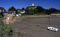
.jpg)   .jpg)  Views of Bréhat | |
 Flag  Coat of arms | |
Location of Bréhat  | |
 Bréhat  Bréhat | |
| Coordinates: 48°50′51″N 3°00′00″W / 48.8475°N 3.0000°W | |
| Country | France |
| Region | Brittany |
| Department | Côtes-d'Armor |
| Arrondissement | Saint-Brieuc |
| Canton | Paimpol |
| Government | |
| • Mayor (2020–2026) | Olivier Carré[1] |
| Area 1 | 3.09 km2 (1.19 sq mi) |
| Population (2021)[2] | 402 |
| • Density | 130/km2 (340/sq mi) |
| Time zone | UTC+01:00 (CET) |
| • Summer (DST) | UTC+02:00 (CEST) |
| INSEE/Postal code | 22016 /22870 |
| Elevation | 0–34 m (0–112 ft) |
| Website | www |
| 1 French Land Register data, which excludes lakes, ponds, glaciers > 1 km2 (0.386 sq mi or 247 acres) and river estuaries. | |
Bréhat (French: Île-de-Bréhat, French pronunciation: [il də bʁea]; Breton: Enez Vriad) is an island and commune located near Paimpol, a mile off the northern coast of Brittany. Administratively, it is a commune in the Côtes-d'Armor department in northwestern France.
Bréhat is actually an archipelago composed of two main islands, separated only at high tide, and many smaller ones. It is famous for its pink granite rocks, very mild micro-climate and Mediterranean vegetation, due to the warm Gulf Stream coming from across the Atlantic.
Many day-trippers come to Bréhat every day by the ferry service (les Vedettes de Bréhat) which sails from Pointe de l'Arcouest, to the north of Paimpol, taking about 10 minutes.[3] They come to visit the main tourist attractions, the Paon and Rosedo lighthouses, the St-Michel chapel, the Guerzido beach, the Birlot [fr] water-mill and the Verrerie of Bréhat. In June 2023 the local municipality imposed a limit on the numbers of summer tourists, citing "overtourism".[4]
Climate[edit]
Bréhat features a temperate oceanic climate with mild winters, dry summers and lower precipitation levels than continental Brittany as a result of the effects of the Gulf Stream,[5] favoring a wide diversity of plants and flowers such as mimosas, hortensias, ceanothus, echiums and agapanthus. It is one of the few places in Brittany and its surroundings where palm trees and other Mediterranean plants can grow naturally due to the scarcity of frosts throughout the year.
| Climate data for Île-de-Bréhat (1961–1990) | |||||||||||||
|---|---|---|---|---|---|---|---|---|---|---|---|---|---|
| Month | Jan | Feb | Mar | Apr | May | Jun | Jul | Aug | Sep | Oct | Nov | Dec | Year |
| Mean daily maximum °C (°F) | 8.9 (48.0) |
9.0 (48.2) |
10.4 (50.7) |
11.9 (53.4) |
14.6 (58.3) |
17.1 (62.8) |
19.4 (66.9) |
19.9 (67.8) |
18.7 (65.7) |
15.9 (60.6) |
12.0 (53.6) |
10.0 (50.0) |
14.0 (57.2) |
| Daily mean °C (°F) | 6.8 (44.2) |
6.8 (44.2) |
8.0 (46.4) |
9.4 (48.9) |
11.9 (53.4) |
14.4 (57.9) |
16.6 (61.9) |
17.1 (62.8) |
16.0 (60.8) |
13.5 (56.3) |
10.0 (50.0) |
8.0 (46.4) |
11.5 (52.7) |
| Mean daily minimum °C (°F) | 4.7 (40.5) |
4.6 (40.3) |
5.5 (41.9) |
6.9 (44.4) |
9.2 (48.6) |
11.7 (53.1) |
13.8 (56.8) |
14.3 (57.7) |
13.4 (56.1) |
11.1 (52.0) |
7.9 (46.2) |
6.0 (42.8) |
9.1 (48.4) |
| Average precipitation mm (inches) | 85.0 (3.35) |
69.5 (2.74) |
62.5 (2.46) |
45.0 (1.77) |
56.0 (2.20) |
39.6 (1.56) |
36.1 (1.42) |
36.3 (1.43) |
51.5 (2.03) |
69.0 (2.72) |
88.7 (3.49) |
83.5 (3.29) |
722.8 (28.46) |
| Average relative humidity (%) | 87 | 85 | 85 | 85 | 86 | 87 | 87 | 86 | 86 | 86 | 85 | 85 | 86 |
| Mean monthly sunshine hours | 61.7 | 87.3 | 134.5 | 180.3 | 224.3 | 223.2 | 238.2 | 220.9 | 169.8 | 122.7 | 72.3 | 56.3 | 1,791.5 |
| Source: Infoclimat.fr[6] | |||||||||||||
Population[edit]
| Year | Pop. | ±% p.a. |
|---|---|---|
| 1968 | 653 | — |
| 1975 | 553 | −2.35% |
| 1982 | 511 | −1.12% |
| 1990 | 461 | −1.28% |
| 1999 | 421 | −1.00% |
| 2009 | 429 | +0.19% |
| 2014 | 392 | −1.79% |
| 2020 | 377 | −0.65% |
| Source: INSEE[7] | ||
Inhabitants of Île-de-Bréhat are called Bréhatins in French.
Sights[edit]
- Héaux de Bréhat Lighthouse
- Rosedo Lighthouse
- Chapelle Saint Michel
- Paon Lighthouse
- Chapelle Keranroux
- Verrerie of Brehat
-
 La Croix Lighthouse
 -
 Paon Lighthouse
 -
 Chapelle St Michel
 -
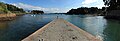 Bréhat island's enclosed harbour, at high tide
 -
 Chapelle Keranoux
 -
 St Michael's chapel


People linked to Île-de-Bréhat[edit]
- Pierre-Marie Le Bozec- Naval officer who lived and died here
- André César Vermare (1869–1949), renowned sculptor who resided and died in the island
- Marc Chagall (1887–1985), painted La fenêtre sur l'Ile de Bréhat, 1924, kept at Vereinigung Zürcher Kunstfreunde.[8]
- Goudji (born 1941), the Georgian-born French sculptor and goldsmith, frequently resides in Bréhat; in 2008 he offered an item and participated in an auction to restore local religious monuments
- Marie-José Chombart de Lauwe, resistance fighter.
See also[edit]
References[edit]
- ^ "Répertoire national des élus: les maires" (in French). data.gouv.fr, Plateforme ouverte des données publiques françaises. 4 May 2022.
- ^ "Populations légales 2021". The National Institute of Statistics and Economic Studies. 28 December 2023.
- ^ "Bréhat island - Ile de Bréhat, Brittany France - Accommodation, Ferries, Attractions". www.brittanyholidayguide.com. Retrieved 13 January 2024.
- ^ "Trendy French island limits visitors to fight 'overtourism'". France 24 (English). 16 June 2023. Retrieved 16 June 2023.
- ^ Vergez-Tricom, Geneviève (1925). La Géographie: " L'île de Bréhat ". p. 44.
- ^ "Normes et records 1961–1990: Ile de Bréhat, Côtes-d'Armor(22), 25 m" (in French). Infoclimat. Archived from the original on 9 December 2008. Retrieved 9 January 2016.
{{cite web}}: CS1 maint: unfit URL (link) - ^ Population en historique depuis 1968, INSEE
- ^ "Marc Chagall at Vereinigung Zürcher Kunstfreunde". Archived from the original on 23 March 2012. Retrieved 17 July 2011.
External links[edit]
- Mairie de Bréhat (Island town home)
- Vedettes de Bréhat (ferry boat company)
- Tourism in Brehat
- Base Mérimée: Search for heritage in the commune, Ministère français de la Culture. (in French)
| International | |
|---|---|
| National | |
This Côtes-d'Armor geographical article is a stub. You can help Wikipedia by expanding it. |