
Airolo railway station
Airolo | |||||||||||||||||||||||||||||
|---|---|---|---|---|---|---|---|---|---|---|---|---|---|---|---|---|---|---|---|---|---|---|---|---|---|---|---|---|---|
 Airolo station building and platforms | |||||||||||||||||||||||||||||
| General information | |||||||||||||||||||||||||||||
| Location | Viale Stazione Airolo Switzerland | ||||||||||||||||||||||||||||
| Coordinates | 46°31′39.094″N 8°36′31.032″E / 46.52752611°N 8.60862000°E | ||||||||||||||||||||||||||||
| Elevation | 1,142 m (3,747 ft) | ||||||||||||||||||||||||||||
| Owned by | Swiss Federal Railways | ||||||||||||||||||||||||||||
| Line(s) | Gotthard line | ||||||||||||||||||||||||||||
| Distance | 86.2 km (53.6 mi) from Immensee[1] | ||||||||||||||||||||||||||||
| Train operators | |||||||||||||||||||||||||||||
| Connections | Autopostale bus lines[2] | ||||||||||||||||||||||||||||
| Other information | |||||||||||||||||||||||||||||
| Fare zone | 244 (arcobaleno)[3] | ||||||||||||||||||||||||||||
| Passengers | |||||||||||||||||||||||||||||
| 2018 | 370 per weekday[4] | ||||||||||||||||||||||||||||
| Services | |||||||||||||||||||||||||||||
| |||||||||||||||||||||||||||||
| Location | |||||||||||||||||||||||||||||
 | |||||||||||||||||||||||||||||
Airolo railway station (Italian: Stazione di Airolo) is a railway station in the Swiss canton of Ticino and municipality of Airolo. The station is on the original line of the Swiss Federal Railways Gotthard railway, at the southern entrance to the Gotthard Tunnel. Most trains on the Gotthard route now use the Gotthard Base Tunnel and do not pass through Airolo station.[1][5]
The station has three platform tracks, served by a side platform and an island platform, connected by a pedestrian subway. The station building, on the side platform, includes a kiosk and a ticket office, but is largely given over to a manufacturer of local yogurts. Just outside the station entrance is a memorial to the lives lost during the construction of the Gotthard Tunnel.
Services[edit]
As of the December 2021 timetable change,[update] the following services stop at Airolo:[6]
- InterRegio: hourly service between Locarno and Arth-Goldau; trains continue to Basel SBB or Zürich Hauptbahnhof.
- S10 / S50: one train per day to Chiasso, Como San Giovanni, or Malpensa Aeroporto Terminal 1.
- Gotthard Panorama Express: daily tourist oriented service between Lugano and Arth-Goldau, with connecting boat service on Lake Lucerne to Lucerne.
Bus services operated by Autopostale terminate in front of the station, and include an hourly service to Bellinzona that parallels the railway, together with a less frequent route across the Novena Pass to Oberwald.[7]
Gallery[edit]
-
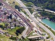 Aerial view of station and tunnel entrance
 -
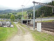 Entrance to the Gotthard tunnel
 -
 The station in the snow
 -
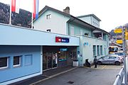 Entrance of station building
 -
 The yoghurt factory on the platform


References[edit]
- ^ a b Eisenbahnatlas Schweiz. Cologne: Schweers + Wall. 2012. p. 47. ISBN 978-3-89494-130-7.
- ^ "Liniennetz Alta Leventina" (PDF). Autopostale. 13 December 2020. p. 8. Archived from the original (PDF) on 11 January 2021. Retrieved 3 January 2021.
- ^ "Comunità tariffale Arcobaleno – Piano delle zone" (PDF) (in Italian). Comunità tariffale Arcobaleno. 2020. Archived from the original (PDF) on 20 September 2020. Retrieved 3 January 2021.
- ^ "Passagierfrequenz". Swiss Federal Railways. September 2019. Retrieved 3 January 2021.
- ^ map.geo.admin.ch (Map). Swiss Confederation. Retrieved 2012-09-23.
- ^ "Göschenen - Airolo - Bellinzona - Chiasso - Milano" (PDF) (in Italian). Bundesamt für Verkehr. 16 December 2021. Retrieved 30 December 2021.
- ^ "Schema di rete - Trasporti pubblici" [Network diagram - Public transport] (in Italian). Canton of Ticino. Archived from the original on 2012-10-30. Retrieved 2012-10-14.
External links[edit]
 Media related to Airolo railway station at Wikimedia Commons
- Airolo railway station – SBB
This article about a railway station in Switzerland is a stub. You can help Wikipedia by expanding it. |