
Bernie, West Virginia
Bernie, West Virginia | |
|---|---|
 Bernie  Bernie | |
| Coordinates: 38°10′49.3″N 82°00′42.5″W / 38.180361°N 82.011806°W | |
| Country | United States |
| State | West Virginia |
| County | Lincoln |
| Elevation | 833 ft (254 m) |
| Time zone | UTC-5 (Eastern (EST)) |
| • Summer (DST) | UTC-4 (EDT) |
| GNIS feature ID | 1741591[1] |
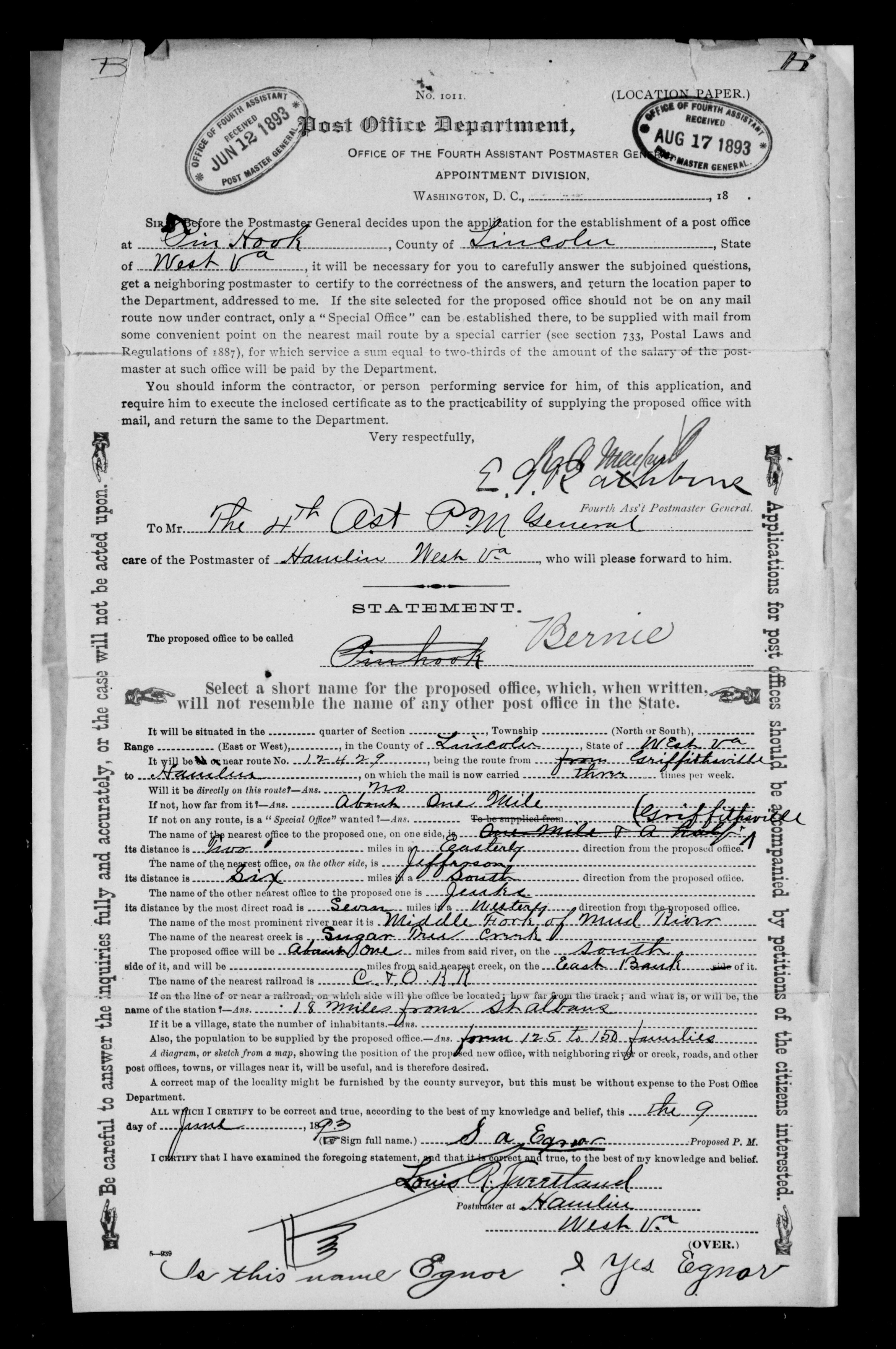
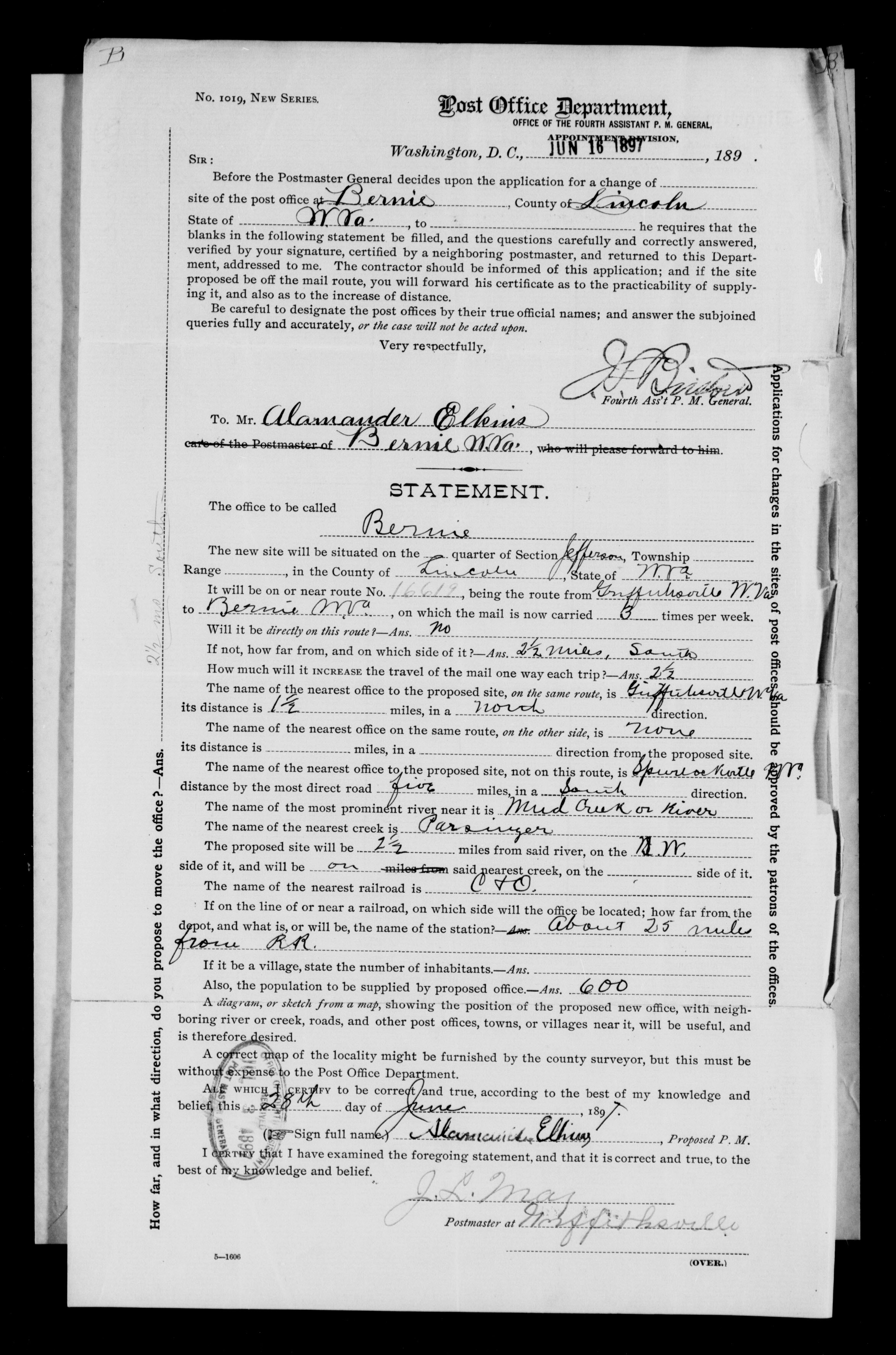
Bernie was an unincorporated community in Lincoln County, West Virginia, United States. It lies along Parsner Creek West Virginia on Lincoln County Route 40/1. It lies approximately 8.5 air miles southeast of the town of Hamlin,[2] the county seat of Lincoln County. Its elevation is 833 feet (254 m).[3] It had a post office[4] that was approved June 12, 1893[5] but then closed on January 8, 1962;[6] there were four Post Masters and the USGS maps of that era show Bernie on West Virginia, Lincoln County, Hager Quad at Location DD: 38.180373, -82.0117982. The first post office was originally proposed to be named "Pin Hook", but was changed to the unincorporated community name of Bernie with an estimated population of 200 according to the initial post office application and was located on the property of S.A. Egnor,[7][unreliable source?] and was later moved approximately 1,800 feet to the property of Alamander Elkins, because he had free gas for heat, on June 16, 1897,[8][unreliable source?] and was operated at that location until it was closed in 1962. After closing the mail for Bernie was rerouted through multiple post offices but the majority went to Griffithsville,[9] West Virginia with the remaining through Alkol,[10] West Virginia.
References[edit]
- ^ U.S. Geological Survey Geographic Names Information System: Bernie, West Virginia
- ^ "How much do you know about your county?".
- ^ "Geographic Names Information System".
- ^ "USPS - Post Offices by City".
- ^ West Virginia: Lewis - Logan. Series: Reports of Site Locations, 1837 - 1950.
- ^ "USPS - Post Offices by City".
- ^ "Photographic image" (JPG). S3.amazonaws.com. Retrieved March 1, 2022.
- ^ "Photographic image" (JPG). S3.amazonaws.com. Retrieved March 1, 2022.
- ^ "ZIP Code 25521 Map, Demographics, More for Griffithsville, WV".
- ^ "ZIP Code 25501 Map, Demographics, More for Alkol, WV".
Municipalities and communities of Lincoln County, West Virginia, United States | ||
|---|---|---|
| Towns | 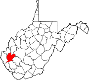 | |
| CDPs | ||
| Unincorporated communities |
| |
| Footnotes | ‡This populated place also has portions in an adjacent county or counties | |
This West Virginia-related article is a stub. You can help Wikipedia by expanding it. |