
Garretts Bend, West Virginia
Garretts Bend, West Virginia | |
|---|---|
 Garretts Bend  Garretts Bend | |
| Coordinates: 38°18′14″N 81°54′53″W / 38.30389°N 81.91472°W | |
| Country | United States |
| State | West Virginia |
| County | Lincoln |
| Elevation | 682 ft (208 m) |
| Time zone | UTC-5 (Eastern (EST)) |
| • Summer (DST) | UTC-4 (EDT) |
| GNIS feature ID | 1539350[1] |
Garretts Bend is an unincorporated community on the Trace Fork of the Mud River in northeastern Lincoln County, West Virginia, United States.[2] It lends its name to the United States Geological Survey's "Garretts Bend" Quadrangle.[3] The village is spread out above an eastward bend of the Trace Fork, where the Hayzlett Fork meets the Williams Fork.[i][2][3] Garretts Bend Road (County Highway 5) runs through the village on its route from Griffithsville to Sod, and meets Toney Branch Road (County Highway 58) just above the bend.[4] To the east along Garretts Bend Road is the Garretts Bend Community Center, while the Garrett Cemetery sits upon a hilltop overlooking the same highway to the southwest.[4]
A 1909 topographical survey map shows about a dozen structures spread out along the creek and its various tributaries, including a church on the south side of Garretts Bend Road just west of where the highway crosses the Hayzlett Fork.[2] In 1933, a similar number of structures is located in the same vicinity, although some of those from 1909 no longer exist. The church is gone, but a schoolhouse sits on a point of land surrounded by the bend.[2] The schoolhouse is still there in 1958 and 1978, and Elizabeth Church is located near the site of the 1909 church.[ii][3] The Garretts Bend Post Office [5] was established in 1876, and maintained until 1965, when it was discontinued, and the mail redirected to Hamlin.[6]
Notes[edit]
- ^ The name "Williams Fork" appears on the 1909 and 1933 topographical survey maps, but in 1958 this is labeled part of Joes Creek, and in 1978 it is part of the main branch of the Trace Fork, previously identified as the Dry Branch.
- ^ For unknown reasons, the words "Elizabeth Church" are located by the schoolhouse, but the church itself is shown further south, along the main highway.
References[edit]
- ^ U.S. Geological Survey Geographic Names Information System: Garretts Bend
- ^ a b c d United States Geological Survey Topographical Survey Map, West Virginia, Saint Albans Quadrangle (eds. Apr. 1909, 1933).
- ^ a b c United States Geological Survey Topographical Survey Map, West Virginia, Garretts Bend Quadrangle (eds. 1958; revised 1971, 1978).
- ^ a b Google Maps, Garretts Bend, WV 25564, retrieved 17 July 2023.
- ^ U.S. Geological Survey Geographic Names Information System: Garretts Bend Post Office (historical)
- ^ United States Post Office Department, Record of Appointment of Postmasters, 1832–1971, NARA Microfilm Publication M841, West Virginia, Lincoln County, vol. 29 (1858–1876), p. 385, vol. 51 (1877–1891), p. 105, vol. 72 (1890–1904), p. 175, vol. 99 (1904–1930), p. 453, vol. 78 (1930–1971), p. 12.
Municipalities and communities of Lincoln County, West Virginia, United States | ||
|---|---|---|
| Towns | 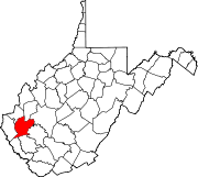 | |
| CDPs | ||
| Unincorporated communities |
| |
| Footnotes | ‡This populated place also has portions in an adjacent county or counties | |
This article about a location in Lincoln County, West Virginia is a stub. You can help Wikipedia by expanding it. |