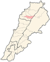
Billa, Lebanon
Billa
بلا | |
|---|---|
Municipality | |
| Coordinates: 34°16′59″N 35°53′53″E / 34.2829326°N 35.8980341°E | |
| Country | |
| Governorate | North Governorate |
| District | Bsharri District |
| Elevation | 1,221 m (4,006 ft) |
| Time zone | UTC+2 (EET) |
| • Summer (DST) | UTC+3 (EEST) |
| Dialing code | +06 |
Billa (Arabic: بلا) is a municipality in the Bsharri District, North Governorate of Lebanon. [1] The village is located near the towns of Barhalyoun and Aabdine. In 2014, there were 429 voters with 220 males and 209 females.[2]
References[edit]
- ^ "GeoNames.org". www.geonames.org. Retrieved 2023-02-28.
- ^ "معلومات عن بلدة المغر وبلا - Billa، قضاء بشري في محافظة الشمال، حسب لوائح الناخبين الرسمية الصادرة عن وزارة الداخلية اللبنانية لسنة ٢٠١٤". إعْرَفْ لبنان. Retrieved 2023-02-28.


