
Brouay War Cemetery
This article includes a list of general references, but it lacks sufficient corresponding inline citations. (July 2018) |
| Brouay War Cemetery | |
|---|---|
| Commonwealth War Graves Commission | |
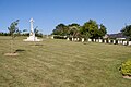
 Brouay war cemetery adjacent to Brouay Church | |
| For Operation Overlord | |
| Established | 1944 |
| Location | 49°12′53″N 0°33′43″W / 49.2148°N 0.5619°W near |
| Designed by | Philip D. Hepworth |
| Total burials | 370 |
Unknowns | 7 |
| Burials by nation | |
| Burials by war | |
| Statistics source: Cemetery details. Commonwealth War Graves Commission. | |
Brouay War Cemetery is a Second World War cemetery of Commonwealth soldiers in France, located between Caen and Bayeux, Normandy. The cemetery contains 377 graves, of which 7 are unidentified.[1] The cemetery is adjacent to the commune's graveyard.
History[edit]
During the Allies push out of the Normandy bridgeheads, a key target was the taking of Caen. The majority of those interred in the cemetery were killed in heavy fighting in late June and July 1944 as the Allies encircled Caen (Operation Epsom, Operation Jupiter and Operation Spring).
Location[edit]
The cemetery is midway between Bayeux and Caen, in the Calvados department, on the Route d'Audrieu (D.94). It is located 3.25 kilometres southeast of Bayeux. Access is via some steps at the eastern corner of Brouay Church.
Photographs[edit]
-
 Sacrificial cross in Brouay war cemetery
 -
 Brouay war cemetery
 -
 Graves in the cemetery
 -
 Graves and cross in the cemetery
 -
 Entrance to Brouay war cemetery
.JPG)


See also[edit]
- American Battle Monuments Commission
- UK National Inventory of War Memorials
- German War Graves Commission
- List of military cemeteries in Normandy
References[edit]
- ^ "Cemetery". www.cwgc.org.
Further reading[edit]
- Shilleto, Carl, and Tolhurst, Mike (2008). "A Traveler's Guide to D-Day and the Battle of Normandy". Northampton, Mass.: Interlink. ISBN 1-56656-555-3