
Cambes-en-Plaine War Cemetery
| Cambes-en-Plaine War Cemetery | |
|---|---|
| Commonwealth War Graves Commission | |
 | |
| For Operation Overlord | |
| Established | 1944 |
| Location | 49°14′10″N 0°23′08″W / 49.2362°N 0.3855°W near Cambes-en-Plaine, Calvados, France |
| Designed by | Philip D. Hepworth |
| Total burials | 224 |
Unknowns | 1 |
| Burials by nation | |
United Kingdom: 224 | |
| Burials by war | |
| Statistics source: Cemetery details. Commonwealth War Graves Commission. | |
Cambes-en-Plaine War Cemetery is a Second World War cemetery of Commonwealth soldiers in France, located seven km northwest of Caen, Normandy. The cemetery contains 224 graves of which one is unidentified.[1]
History[edit]
Following the Allied landings on D-Day, elements of the East Riding Yeomanry, supporting the British 3rd Infantry Division pushed through to the northern outskirts of Cambes-en-Plaine on 9 June 1944. A defensive German line here stopped the advance on Caen. A large number of burials date to between the 8 and 12 July 1944, during Operation Charnwood, the final attack on Caen. Over half of the burials in the graveyard are from soldiers in the 59th (Staffordshire) Infantry Division.
Location[edit]
The cemetery is located in the commune of Cambes-en-Plaine, in the Calvados department of Normandy, on the Rue du Mesnil Ricard (D.79B).
Photographs[edit]
-
 Entrance to the war cemetery
 -
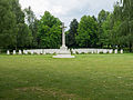 Sacrificial cross in the cemetery
 -
 Brouay war cemetery
 -
 Graves of 59th (Staffordshire) Division soldiers


See also[edit]
- American Battle Monuments Commission
- UK National Inventory of War Memorials
- German War Graves Commission
- List of military cemeteries in Normandy
References[edit]
Further reading[edit]
- Shilleto, Carl, and Tolhurst, Mike (2008). A Traveler's Guide to D-Day and the Battle of Normandy. Northampton, Mass.: Interlink. ISBN 1566565553