
Coonalpyn, South Australia
This article needs additional citations for verification. (July 2018) |
| Coonalpyn South Australia | |||||||||||||||
|---|---|---|---|---|---|---|---|---|---|---|---|---|---|---|---|
 Aerial view of Coonalpyn | |||||||||||||||
 Coonalpyn | |||||||||||||||
| Coordinates | 35°41′54″S 139°51′19″E / 35.6983°S 139.855246°E[1] | ||||||||||||||
| Population | 193 (UCL 2021)[2] | ||||||||||||||
| Established | 25 November 1909 (town) 24 August 2000 (locality)[3][4] | ||||||||||||||
| Postcode(s) | 5265[5] | ||||||||||||||
| Elevation | 22 m (72 ft)(railway station)[6] | ||||||||||||||
| Time zone | ACST (UTC+9:30) | ||||||||||||||
| • Summer (DST) | ACST (UTC+10:30) | ||||||||||||||
| Location |
| ||||||||||||||
| LGA(s) | The Coorong District Council[1] | ||||||||||||||
| Region | Murray and Mallee[1] | ||||||||||||||
| County | Buccleuch[1] | ||||||||||||||
| State electorate(s) | MacKillop | ||||||||||||||
| Federal division(s) | Barker[7] | ||||||||||||||
| |||||||||||||||
| |||||||||||||||
| Footnotes | Locations[1][5] Adjoining localities[1] | ||||||||||||||
Coonalpyn is a town and a locality in the Australian state of South Australia located about 143 kilometres (89 mi) south-east of the state capital of Adelaide and about 61 kilometres (38 mi) south-east of the municipal seat in Tailem Bend. It is situated in the local government area of the Coorong District Council and is in the State electoratal district of MacKillop and the Federal division of Barker.
Origin of the name[edit]

This town's name is derived from the Aboriginal word Coonalpyn, meaning Barren Woman. Coonalpyn Downs was chosen by John Barton Hack to name the property and the railway station within this property.
History[edit]
The town of Coonalpyn was proclaimed on 25 November 1909.[3]
In 1927, the Congregational Church in Coonalpyn erected its church building, and is now the Coonalpyn Uniting Church.
Coonalpyn was originally known as part of the Ninety Mile Desert, until in approximately 1949 when the land was developed by the AMP Society.
The town became the seat for the District Council of Coonalpyn Downs which was established on 30 May 1957.[9]
Electricity came to Coonalpyn through ETSA in 1962 and the Tailem Bend–Keith pipeline was constructed in 1968.
In 1997, the District Council of Coonalpyn Downs amalgamated with the Peake District Council and Meningie District Council to form The Coorong District Council.[10]
Boundaries for the locality of Coonalpyn were created on 24 August 2000.[4]
Lutheran History of the Area[edit]
A group of Lutheran Settlers moved to the Coonalpyn District in the early 1920s, the first congregation, Bethlehem Lutheran Congregation, being formed on 9 March 1930. A second congregation, Immanuel Lutheran Congregation, was formed on 28 July 1940. In 1952, the two congregations conjointly decided to erect a church and move out of the old town institute into the new Coonalpyn Lutheran Church. The church was finished and dedicated in 1953. When Lutheran Amalgamation occurred in 1966, the United Evangelical Lutheran Church in Australia (UELCA) & Evangelical Lutheran Church of Australia (ELCA) congregations merged to form the Redeemer Lutheran Congregation, and a new parish was formed which included congregations at Tintinara and Meningie.[11]
Sporting Teams[edit]
In 1992, the Border-Downs Magpies and Tintinara Blues amalgamated to form the Border-Downs Tintinara Crows Football Club. The club was then a member of the River Murray Football League, and in 2001 joined the Mallee Football League. This also includes the Crows Netball Club.
Coonalpyn also has a tennis club which belongs to the Border-Downs Tennis Association including towns such as Malinong, Culburra, Yumali, Coomandook, Tintinara & Ki Ki
There is also an active lawn bowls club which has a series of "community bowls" nights during the summer months to encourage the community to come and try lawn bowls.
Photo gallery[edit]
-
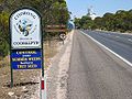 Entrance to Coonalpyn, Adelaide end
 -
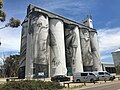 Art on silos at Coonalpyn
 -
 End view
 -
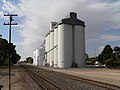 ABB silos in 2007 (prior to decoration)
 -
 Town Hall/Institute
 -
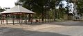 Parking bay rest area
 -
 Old Coonalpyn train station
 -
 Community swimming pool
 -
 War Memorial
 -
 Redeemer Lutheran Church
 -
 Uniting Church
 -
 Coonalpyn Bakery
 -
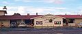 Coonalpyn Hotel


See also[edit]
References[edit]
- ^ a b c d e f "Search results for "Coonalpyn, LOCB" with the following datasets selected – 'Suburbs and Localities', 'Counties', 'Government Towns', 'Hundreds', 'Local Government Areas', 'SA Government Regions' and 'Gazetteer'". Location SA Map Viewer. Government of South Australia. Retrieved 6 December 2018.
- ^ Australian Bureau of Statistics (28 June 2022). "Coonalpyn (urban centre and locality)". Australian Census 2021.
- ^ a b Bice, John G. (25 November 1909). "Town of Coonalpyn" (PDF). The South Australian Government Gazette. Government of South Australia. p. 1027. Retrieved 6 April 2019.
- ^ a b "GEOGRAPHICAL NAMES ACT 1991, Notice to Assign Boundaries and Names to Places" (PDF), The South Australian Government Gazette: 596, 24 August 2000, retrieved 5 January 2018
- ^ a b "Postcode for Coonalpyn, South Australia". Postcodes Australia. Retrieved 6 December 2018.
- ^ "Search results for "Coonalpyn Railway Station" with the following datasets selected – 'Suburbs and Localities' and 'Gazetteer'". Location SA Map Viewer. Government of South Australia. Retrieved 6 December 2018.
- ^ "Federal electoral division of Barker" (PDF). Australian Electoral Commission. Retrieved 28 March 2016.
- ^ a b c "Monthly climate statistics: Summary statistics Summary statistics MENINGIE (nearest weather station)". Commonwealth of Australia , Bureau of Meteorology. Retrieved 5 January 2018.
- ^ Rowe, Colin D. (30 May 1957). "LOCAL GOVERNMENT ACT, 1934-1957: CONSTITUTION OF DISTRICT COUNCIL DISTRICT OF COONALPYN DOWNS" (PDF). The South Australian Government Gazette. Government of South Australia. pp. 1377–1378. Retrieved 6 April 2019.
- ^ Kerin, R.G. (13 February 1997). "LOCAL GOVERNMENT ACT 1934 SECTIONS 7 AND 14: AMALGAMATION OF THE DISTRICT COUNCIL OF COONALPYN DOWNS, THE DISTRICT COUNCIL OF MENINGIE AND THE DISTRICT COUNCIL OF PEAKE" (PDF). The Government Gazette of South Australia. Government of South Australia. pp. 900–903. Retrieved 6 April 2019.
- ^ "Lutheran History of Coonalpyn". Coonalpyn Lutheran Parish. Archived from the original on 5 April 2016. Retrieved 24 March 2016.