
Kiviõli
This article needs additional citations for verification. (February 2020) |
Kiviõli | |
|---|---|
 | |
 Kiviõli Location in Estonia | |
| Coordinates: 59°21′N 26°58′E / 59.350°N 26.967°E | |
| Country | |
| County | |
| Municipality | |
| Founded | 1922 |
| Town rights | 1946 |
| Area | |
| • Total | 11.75 km2 (4.54 sq mi) |
| Population (2021)[1] | |
| • Total | 4,725 |
| • Rank | 23rd |
| • Density | 400/km2 (1,000/sq mi) |
| Ethnicity | |
| • Estonians | 39.6% |
| • Russians | 51.5% |
| • other | 8.9% |
| Time zone | UTC+2 (EET) |
| • Summer (DST) | UTC+3 (EEST) |
Kiviõli is an industrial town in Ida-Viru County, Estonia, established in 1922. The main industry in the town is oil shale mining, which gives the town its name (literally 'stone oil').
History[edit]
In 1922, the joint-stock company Eesti Kiviõli (i.e., 'Estonian stone oil') established an oil shale quarry in land belonging to the village of Salaküla, and mining commenced in 1930. A worker's settlement belonging to the village of Varinurme was built in the 1930s and named Kiviõli after the joint-stock company. Kiviõli became a town in 1946.[2]
Demographics[edit]
| Ethnicity | 1959[3] | 1970[4] | 1979[5] | 1989[5] | 2000[6] | 2011[7] | 2021[8] | |||||||
|---|---|---|---|---|---|---|---|---|---|---|---|---|---|---|
| amount | % | amount | % | amount | % | amount | % | amount | % | amount | % | amount | % | |
| Estonians | 6017 | 57.6 | 5789 | 51.9 | 4914 | 44.5 | 3958 | 38.1 | 2921 | 39.5 | 2179 | 38.7 | 1924 | 39.6 |
| Russians | - | - | 4431 | 39.7 | 5184 | 47.0 | 5369 | 51.7 | 3793 | 51.2 | 3020 | 53.6 | 2498 | 51.5 |
| Ukrainians | - | - | 152 | 1.36 | 228 | 2.06 | 308 | 2.96 | 157 | 2.12 | 109 | 1.93 | 136 | 2.80 |
| Belarusians | - | - | 93 | 0.83 | 139 | 1.26 | 184 | 1.77 | 119 | 1.61 | 79 | 1.40 | 69 | 1.42 |
| Finns | - | - | 368 | 3.30 | 348 | 3.15 | 308 | 2.96 | 193 | 2.61 | 100 | 1.77 | 68 | 1.40 |
| Jews | - | - | 13 | 0.12 | 11 | 0.10 | 10 | 0.10 | 3 | 0.04 | 2 | 0.04 | 0 | 0.00 |
| Latvians | - | - | 41 | 0.37 | 25 | 0.23 | 19 | 0.18 | 10 | 0.14 | 10 | 0.18 | 10 | 0.21 |
| Germans | - | - | - | - | 74 | 0.67 | 83 | 0.80 | 46 | 0.62 | 49 | 0.87 | 31 | 0.64 |
| Tatars | - | - | - | - | 13 | 0.12 | 26 | 0.25 | 14 | 0.19 | 7 | 0.12 | 6 | 0.12 |
| Poles | - | - | - | - | 26 | 0.24 | 22 | 0.21 | 11 | 0.15 | 7 | 0.12 | 7 | 0.14 |
| Lithuanians | - | - | 18 | 0.16 | 27 | 0.24 | 24 | 0.25 | 17 | 0.23 | 14 | 0.25 | 12 | 0.25 |
| unknown | 0 | 0.00 | 0 | 0.00 | 0 | 0.00 | 0 | 0.00 | 70 | 0.94 | 4 | 0.07 | 5 | 0.10 |
| other | 4427 | 42.4 | 248 | 2.22 | 61 | 0.55 | 79 | 0.76 | 51 | 0.69 | 54 | 0.96 | 86 | 1.77 |
| Total | 10444 | 100 | 11153 | 100 | 11050 | 100 | 10390 | 100 | 7405 | 100 | 5634 | 100 | 4854 | 99.9 |
Neighborhoods of Kiviõli[edit]
Included in the town limits, but somewhat separate from the main part of the town, are the districts of Küttejõu and Varinurme.
There are five neighborhoods of Kiviõli:
- Küttejõu
- Lepatee
- Sala-Aru
- Soopealse
- Varinurme.[9]
Gallery[edit]
-
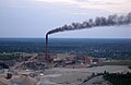 Kiviõli oil factory
 -

-

-
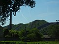 Ash mountains

.JPG)


See also[edit]
References[edit]
- ^ "Population by sex, age group and place of residence after the 2017 administrative reform, 1 January". Statistics Estonia. Retrieved 26 December 2021.
- ^ "Kiviõli". Dictionary of Estonian Place Names. Tallinn: Eesti Keele Instituut. Retrieved 15 February 2024.
- ^ Katus, Kalev; Puur, Allan; Põldma, Asta (2002). Rahvastiku ühtlusarvutatud sündmus- ja loendusstatistika: Ida-Virumaa 1965-1990. Sari C (in Estonian and English). Tallinn: Eesti Kõrgkoolidevaheline Demouuringute Keskus. pp. 31–32. ISBN 9985-820-66-5.
- ^ Население районов, городов и поселков городского типа Эстонской ССР : по данным Всесоюзной переписи населения на 15 января 1970 года. Таллинн, 1972.
- ^ a b Eesti Vabariigi maakondade, linnade ja alevite rahvastik: 1989. a. rahvaloenduse andmed: statistikakogumik. 1. osa: Rahvaarv rahvuse, perekonnaseisu, hariduse ja elatusallikate järgi. Tallinn: Statistikaamet. 1990. pp. 28, 33. ISBN 978-9949-71-932-7.
- ^ "RL222: RAHVASTIK ELUKOHA JA RAHVUSE JÄRGI". Estonian Statistical Database (in Estonian).
- ^ "RL0429: RAHVASTIK RAHVUSE, SOO, VANUSERÜHMA JA ELUKOHA JÄRGI, 31. DETSEMBER 2011". Estonian Statistical Database (in Estonian).
- ^ "RL21429: RAHVASTIK RAHVUSE, SOO, VANUSERÜHMA JA ELUKOHA (HALDUSÜKSUS) JÄRGI, 31. DETSEMBER 2021". Estonian Statistical Database (in Estonian).
- ^ "LINNAOSADE JA -JAGUDE LÜHENDID". eki.ee (in Estonian). Retrieved 18 March 2020.
External links[edit]
| ||
Jaanilinn (Ivangorod) and Petseri (Pechory) were annexed by the Soviet Union in 1945 and are currently part of Russia. | ||

| International | |
|---|---|
| Geographic | |
59°21′N 26°58′E / 59.350°N 26.967°E
This Estonia location article is a stub. You can help Wikipedia by expanding it. |