
Module talk:Iraqi insurgency detailed map/Archive 4
| This is an archive of past discussions. Do not edit the contents of this page. If you wish to start a new discussion or revive an old one, please do so on the current talk page. |
| Archive 1 | Archive 2 | Archive 3 | Archive 4 | Archive 5 |
Status of Iraqi border crossings
http://www.understandingwar.org/sites/default/files/Control%20Zone%20Map_5_1_15.pdf
This article, from a reliable source, states that Walid border crossing may be under ISIS control, and that control of the Trebil border crossing is unclear. Now, we have both Walid and Trebil listed as under government control. Should they be changed to contested, or perhaps only Walid? I can't seem to find any other sourced indicating control of these crossings. 2601:0:B200:F7D9:9D20:3A1A:2CA1:AE09 (talk) 19:11, 3 May 2015 (UTC)
- If ISW has no data on it why should we change the status of the border crossings? https://pietervanostaeyen.files.wordpress.com/2015/05/2000px-iraq10.png here a map from anti gov.Spenk01 (talk) 20:56, 3 May 2015 (UTC)
- Area where located the Al Wallid border crossing under control by Iraqi troops. This confirmed (pro Syrian opposition) sources.herehere Hanibal911 (talk) 21:24, 3 May 2015 (UTC)
Thank you all for helping determine the status of the control of these border crossings.2601:0:B200:F7D9:4839:1AB:A62B:CDB5 (talk) 02:24, 4 May 2015 (UTC)
Baiji Refinery
https://twitter.com/SeniorB/status/592224791832166400 Pro-Kurdish Rudaw Reporter and if true, IS forces are deep in Baiji Refinery and it needs to turn to contested. Tgoll774 (talk) 11:38, 26 April 2015 (UTC)
https://pbs.twimg.com/media/CDiZvAqWMAICDOa.png Pro-ISIS source It looks like a third of the refinery captured and the place cut off which aligns with other IS sources saying they cut it off and are clearing the barracks. Leave to our Arab speakers to check other sources for corroboration. Tgoll774 (talk) 18:42, 26 April 2015 (UTC)
https://twitter.com/shlonesh/status/592672236353499137
If these are true, Baiji Refinery has been overrun, leave it here to corroborate with other sources Tgoll774 (talk) 14:46, 27 April 2015 (UTC)
https: // justpaste. it/ kt8t If true, then again Baiji is overrun Tgoll774 (talk) 13:06, 28 April 2015 (UTC)
Confirmed: https://www.youtube.com/watch?v=jOh6N-g0B4Q&feature=youtu.be Baiji must go to contested. IS fighters are clearly in the Czech Barracks and the Distillery towers. Tgoll774 (talk) 18:55, 28 April 2015 (UTC)
https://www.youtube.com/watch?v=BUeTsMGvcRY This clinches it, Baiji is clearly being contested, if not taken by IS. Tgoll774 (talk) 11:59, 29 April 2015 (UTC)
https://www.youtube.com/watch?v=bpo4QjsOPIQ Al-Jazeera Tgoll774 (talk) 13:57, 30 April 2015 (UTC)
80 percent of the refinery was held by the IS group. A second senior Energy Police official said recently but still the refinery isnt shows contested why?
source http://www.iraqoilreport.com/news/iraqi-forces-overpowered-at-baiji-refinery-14460/ http://english.shafaaq.com/security/14184-isis-controls-half-of-baiji-refinery-sites-in-its-20th-attack.html
(Jack6780 (talk) 23:08, 30 April 2015 (UTC))
https://www.youtube.com/watch?v=NHwXyLq4Qlw&feature=youtu.be The evidence is overwhelming that IS controls the vast majority of Baiji Refinery and it needs to switch to IS Control Tgoll774 (talk) 17:56, 3 May 2015 (UTC)
Confirms Baiji City under IS control. Tgoll774 (talk) 23:43, 4 May 2015 (UTC)
Kirkuk Province
https://twitter.com/shlonesh/status/596309461582651392/photo/1 claim by IS to have taken some fields. As is typical it might be so, but ISF won't admit for a few days as they are attempting to get it back Tgoll774 (talk) 16:10, 7 May 2015 (UTC)
Alas & Ajeel oilfields
https://www.youtube.com/watch?v=LnonPrykrLY Purportedly taken in these fields. IS claims control. Tgoll774 (talk) 18:53, 8 May 2015 (UTC)
Proposal to switch all Iraq and Syria Updates to Syria/Iraq Combined Module
Since since this is increasingly expanding, for ease of updating, I propose both Syria and Iraq updates be discussed here https://en.wikipedia.org/w/index.php?title=Module:Syrian_and_Iraqi_insurgency_detailed_map/doc&action=edit and that joint map be the sole map with this and the Syrian one dropped for ease of editing, discussion, and debate. Its easier for all involved without having to switch in between modules. Tgoll774 (talk) 15:19, 9 May 2015 (UTC)
- No personal preference, though because you added this to the top of the talk page, people may miss it entirely as they scroll to the bottom to read new things. Banak (talk) 20:05, 9 May 2015 (UTC)
I'll add it to the bottom as well then. Tgoll774 (talk) 22:09, 9 May 2015 (UTC)
Proposal to switch all Iraq and Syria Updates to Syria/Iraq Combined Module
Since since this is increasingly expanding, for ease of updating, I propose both Syria and Iraq updates be discussed here https://en.wikipedia.org/w/index.php?title=Module:Syrian_and_Iraqi_insurgency_detailed_map/doc&action=edit and that joint map be the sole map with this and the Syrian one dropped for ease of editing, discussion, and debate. Its easier for all involved without having to switch in between modules.Tgoll774 (talk) 22:10, 9 May 2015 (UTC)
- Agree. I think this will make it far easier for people to see edits in both maps, and will streamline the process of editing both. 2601:C7:8380:3B01:58E0:9F82:69B5:5ADD (talk) 03:07, 10 May 2015 (UTC)
- I disagree. Both maps are already huge, and a lot of people's computers can barely handle one of them at a time. Jackmcbarn (talk) 04:34, 10 May 2015 (UTC)
Semi-protected edit request on 11 May 2015
This edit request to Module:Iraqi insurgency detailed map has been answered. Set the |answered= or |ans= parameter to no to reactivate your request. |
change
{ lat = "34.889", long = "43.860", mark = "Icon NuclearPowerPlant-black.svg", marksize = "7", label = "Ajil oil field", link = "Ajil oil field", label_size = "0" },
to
{ lat = "34.889", long = "43.860", mark = "Icon NuclearPowerPlant-red.svg", marksize = "7", label = "Ajil oil field", link = "Ajil oil field", label_size = "0" },
Change Ajil Oil Field to Iraqi control. 2601:C7:8380:3B01:C147:1686:F337:CAAD (talk) 23:57, 11 May 2015 (UTC)
ISW just regurgitates what ISF and Kurds tell them which is always unverifiable. They have no one on the ground. IS however has posted video and photos showing them controlling the fields. Whoever made the change must have found enough corroborating evidence for it. Tgoll774 (talk) 00:51, 12 May 2015 (UTC)
When did ISF launch an Anbar Offensive?
I see a whole bunch of cities from Abu Ghraib to Fallujah in East Anbar that went from Black or Contested to red without any source for it. That is a big chang and I see no corroborating evidence for it or news mentioning it.Tgoll774 (talk) 04:07, 12 May 2015 (UTC)
- Hanibal already provided those two sources for those edits on the 10th of May. Check edit history for the said date. Regards.--Damirgraffiti |☺What's Up?☺ 04:17, 12 May 2015 (UTC)
- I can't find them can you link me up? 109.110.113.134 (talk) 20:33, 12 May 2015 (UTC)
- Here's one and here. --Damirgraffiti |☺What's Up?☺ 20:59, 12 May 2015 (UTC)
- I can't find them can you link me up? 109.110.113.134 (talk) 20:33, 12 May 2015 (UTC)
H1, H2, H3
These Airbases were destroyed in 2003 and no longer used with the runways rotting away. They should be removed from the map.Tgoll774 (talk) 00:47, 12 May 2015 (UTC)
- But these Air Bases (H2,H3) not be totally destroyed in 2003! Also in Anbar province later was built new the Air Base(H1)here Hanibal911 (talk) 20:50, 12 May 2015 (UTC)
- We must find out if the Iraq government has a supply line to Walid and Trebil. This Lebanese news agency says Trebil is 'surrounded by ISIS positions'.
- Not sure about Trebil but the Al-tanf side of the Al-walid crossing is now marked as ISIS controlled.
- We must find out if the Iraq government has a supply line to Walid and Trebil. This Lebanese news agency says Trebil is 'surrounded by ISIS positions'.
http://www.dailystar.com.lb/Article.aspx?id=296448&link=Business/Regional/2015/May-01/296448-jordans-overland-trade-hit-by-iraq-syria-border-woes.ashx 2601:C7:8380:3B01:388A:8E8C:FECF:E294 (talk) 20:51, 13 May 2015 (UTC)
Semi-protected edit request on 17 May 2015
This edit request to Module:Iraqi insurgency detailed map has been answered. Set the |answered= or |ans= parameter to no to reactivate your request. |
change
{ lat = "33.221", long = "43.421", mark = "Location dot red.svg", marksize = "6", label = "Qaryat al-Ankur", link = "Qaryat al-Ankur", label_size = "0", position = "top" },
to
{ lat = "33.221", long = "43.421", mark = "Location dot black.svg", marksize = "6", label = "Qaryat al-Ankur", link = "Qaryat al-Ankur", label_size = "0", position = "top" },
and
{ lat = "33.477", long = "43.660", mark = "Abm-red-icon.png", marksize = "7", label = "Saqlawiya Camp", link = "Saqlawiya Camp", label_size = "0", position = "top", },
to
{ lat = "33.477", long = "43.660", mark = "Abm-black-icon.png", marksize = "7", label = "Saqlawiya Camp", link = "Saqlawiya Camp", label_size = "0", position = "top", },
source: http://s6.uplod.ir/i/00601/qkz7ldfbk7b5.jpg
2601:C7:8380:3B01:DDF6:793A:54B8:669F (talk) 18:08, 17 May 2015 (UTC)
Baiji Area
IS claims control of Al Fathah http://wikimapia.org/#lang=en&lat=35.061969&lon=43.550234&z=14&m=b and https://twitter.com/mediaactivsy228/status/598348359938797568
If true, it shows IS is starting its Summer offensive. However, I don't think we'll see the dramatic advance like last summer. ISF's morale despite causalities isn't breaking. Probably be like Syria with stalemates and minor advances for both sides. IS is launching major attacks in Syria as well to take advantage of SyAA's morale crash. Well I'll leave it to the usual editors to corroborate. But I think all the real action this summer will be in Syria. IS has to clear the Euphrates of SyAA if it wants to secure Anbar.Tgoll774 (talk) 14:51, 13 May 2015 (UTC)
http://uk.mobile.reuters.com/article/idUKKBN0NY0TS20150513?irpc=932 Confirms Baiji City is under IS control. Tgoll774 (talk) 00:48, 15 May 2015 (UTC)
http://www.longwarjournal.org/archives/2015/05/strategy-to-defeat-islamic-state-is-working-us-department-of-defense-claims.php Further proof IS controls Baiji and the surroundings. LWJ has accurate info. Baiji should turn black. Tgoll774 (talk) 01:54, 18 May 2015 (UTC)
Ramadi
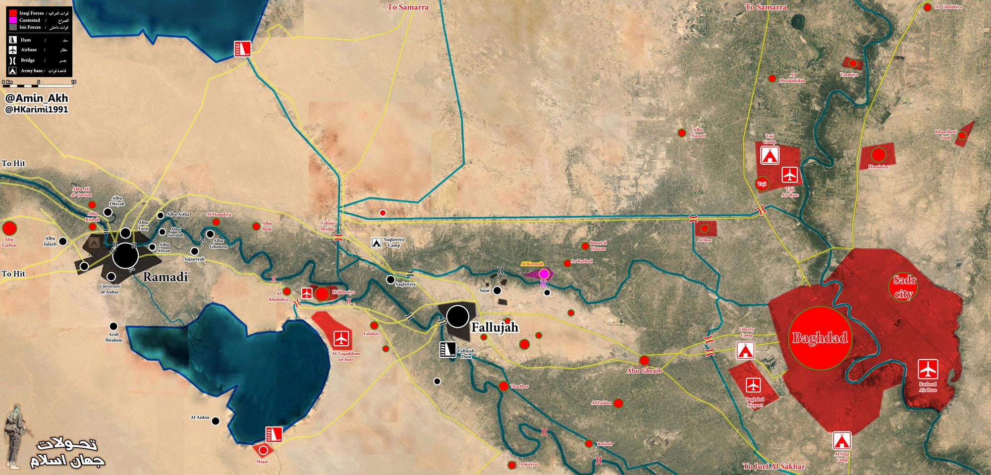
http://s6.uplod.ir/i/00599/nqz8wdbo7ywv.jpg Pro-Shia source. Tgoll774 (talk) 12:07, 15 May 2015 (UTC)
Isil 'seizes Iraqi city of Ramadi'
https://twitter.com/RudawEnglish/status/599198650531647488
now waiting for hanibal to say telegraph and rudaw isnt reliable {Jack6780 (talk) 13:52, 15 May 2015 (UTC)}
http://www.mcclatchydc.com/2015/05/15/266798/islamic-state-takes-ramadi-government.html More confirmation. ISF has collapsed Tgoll774 (talk) 15:42, 15 May 2015 (UTC)
http://www.longwarjournal.org/archives/2015/05/islamic-state-seizes-government-center-in-ramadi.php#comment-72976 Evidence is overwhelming now. Tgoll774 (talk) 16:00, 15 May 2015 (UTC)
And more confirmation
{Jack6780 (talk) 16:13, 15 May 2015 (UTC)}
http://i.imgur.com/g8Nqgyd.jpg This makes only 3% of the city contested. Its a mop up operation now. Change it black. Tgoll774 (talk) 13:03, 17 May 2015 (UTC) http://s6.uplod.ir/i/00599/kwr1cjxjlk2i.jpg Pro Shia, https://pbs.twimg.com/media/CFEd1Y2WYAAvvI8.png Pro IS. Both pretty much agree. I say make Ramadi Black but put a partial red circle west on it because of Eighth Brigade and the small number of holdouts in the western side. Tgoll774 (talk) 19:47, 15 May 2015 (UTC)
- Tgoll774 Pro ISIS source here showed that the some parts a city of Ramadi still not taken ISIS. Al Mala´abAnbar Operations CommandJustice Palace and base of 8th Brigade These objects are also a part of the city and they still not taken. But we can mark Ramadi in black color and put some red dots inside that would display areas which still control Iraqi troops. So what you think about my offer? Hanibal911 (talk) 09:10, 16 May 2015 (UTC)
Fuel depot in the south west to the city Ramadi should also be black according to all the above maps {Jack6780 (talk) 15:55, 16 May 2015 (UTC)}
http://i.imgur.com/g8Nqgyd.jpg Less than 5% of main city under ISF control. Should go black. Tgoll774 (talk) 13:04, 17 May 2015 (UTC)
- Tgoll774 This pro ISIS sourcehere but relaible source reported that the Iraqi troops counterattacked and regained control of Al-Mukhabarat neighbourhood inside the city of Ramadi.Elijah J. Magnier Hanibal911 (talk) 13:27, 17 May 2015 (UTC)
Elijah Magnier isnt a reliable source He is anti ISIS and there are so many instances he was proven wrong Yes he can use for ISIS advances but not for ISF advances {Jack6780 (talk) 13:58, 17 May 2015 (UTC)}
The 8th Army base west of Ramadi is in ISF hands, it's one of the most important bases in the province. Showing it in black is a big mistake in the map.
http://www.longwarjournal.org/archives/2015/05/islamic-state-overruns-anbar-operations-command-takes-full-control-of-ramadi.php Tgoll774 (talk) 23:21, 17 May 2015 (UTC)
- Rudaw is claiming the "entire city" is now in IS hands. According to the province spokesman, "The city was completely taken."'[1] Magog the Ogre (t • c) 02:38, 18 May 2015 (UTC)
ISF Defenses Collapse in Habbaniyah
http://www.longwarjournal.org/archives/2015/05/islamic-state-breaks-iraqi-defensive-line-outside-of-habbaniyah.php LWJ. Tgoll774 (talk) 02:08, 22 May 2015 (UTC)
http://www.cnn.com/2015/05/22/middleeast/isis-syria/ Its getting desperate. Tgoll774 (talk) 19:19, 22 May 2015 (UTC)
Baiji under IS Control
http://www.theguardian.com/world/2015/may/23/iran-sends-troops-retake-iraqi-oil-refinery-isis For weeks I have posted substantial evidence this city was under IS control and has been for months. ISF got ran out of town an the fighting is concentrated at the refinery. Tgoll774 (talk) 17:34, 23 May 2015 (UTC)
- I think so too. The Islamic State is wholly controlling Baiji city while there are still battles ongoing in the oil refinery near Baiji. --햄방이 (talk) 17:44, 23 May 2015 (UTC)
- Siniya is under the Islamic State controll too. # "We have to retake Siniya and Baiji towns to cut all supply routes coming from Anbar province and used by Daesh to send reinforcements whenever they need,” said a source in the Salahuddin Operations Command. Daesh is another name for Islamic State. --햄방이 (talk) 18:14, 23 May 2015 (UTC)
- Any reason why Baiji is marked as contested again? Especially after the article talking about the 16 traders killed earlier.
Fight has been started near Haditha
Yesterday, the Islamic State attacked al-Khasfa near Haditha and they took control of Haditha asphalt factory. The Islamic State and Republic of Iraq is still fighting in there. #--햄방이 (talk) 06:46, 23 May 2015 (UTC)
- Since they are still fighting there shouldn't it be marked as in contention rather than as ISIS....
Al Khasfa was not under the Islamic State controll, but
Al Khasfa was not under the Islamic State controll, but it is now contested between Republic of Iraq and the Islamic State.
And I have a more news; Tharthar dam is under the Islamic State controll--햄방이 (talk) 16:06, 24 May 2015 (UTC)
Thar Thar Dam
https://twitter.com/shnoya3nii/status/591652918044073985/photo/1 Can someone check this out on the Arabic Channels. IS claims control of this. Tgoll774 (talk) 20:37, 24 April 2015 (UTC)
https://www.kuna.net.kw/ArticleDetails.aspx?id=2437722&Language=en Confirmed by this source. IS can't open those gates unless they control them. Tgoll774 (talk) 02:19, 25 April 2015 (UTC)
Who switched Tharthar Dam back to ISF without citing a source for it? Its under IS control as confirmed above and IS video feed. Tgoll774 (talk) 00:38, 26 April 2015 (UTC)
http://www.longwarjournal.org/archives/2015/04/islamic-state-captures-dam-overruns-base-in-western-iraq.php Tgoll774 (talk) 01:53, 26 April 2015 (UTC)
What source says Tharthar Dam was retaken, I don't see a supporting cite saying it was reclaimed by ISF. Tgoll774 (talk) 12:07, 27 April 2015 (UTC)
Tharthar Dam is still held by IS. ISF has not taken it back. Tgoll774 (talk) 17:28, 1 May 2015 (UTC)
Still no evidence provided that Tharthar Dam was retaken by ISF, it should revert back to IS control based on LWJ Tgoll774 (talk) 16:10, 7 May 2015 (UTC)
- Yes, I agree. Tharthar Dam is currently under the Islamic State control. --햄방이 (talk) 16:07, 24 May 2015 (UTC)
Kabisa is not surrounded
Are there any proofs that Kabisa is surrounded? --햄방이 (talk) 18:31, 24 May 2015 (UTC)
Thar Thar base is under the Islamic State control
Are there any sources claiming it is recaptured by Republic of Iraq's military? If there aren't, I will change its colour to black. --햄방이 (talk) 18:41, 24 May 2015 (UTC)
- The dam and the base were recaptured by Security forces 2 days later. https://twitter.com/EjmAlrai/status/592647860790894592 --8fra0 (talk) 16:53, 29 May 2015 (UTC)
Baiji Oil Refinery
Islamic State have taken control of 90 percent of Baiji oil refinery after clashes with Iraqi security forces around the refinery continue and nearly 150 Iraqi soldiers and soldiers were surrounded by the militants inside.WAR Media Hanibal911 (talk) 14:39, 4 May 2015 (UTC)
- The war media source is from May 4th
Who switched Baiji to Red? The Refinery is still heavily contested and largely destroyed. Also Baiji City is under IS control fully as confirmed multiple times by Long War Journal Tgoll774 (talk) 11:57, 2 June 2015 (UTC)
- Source (link, not just a news name) please? Rules are rules, Tgoll774.--Damirgraffiti |☺What's Up?☺ 00:54, 4 June 2015 (UTC)
http://www.longwarjournal.org/archives/2015/06/iraqi-security-forces-shiite-militias-make-gains-in-baiji.php Refinery is still contested Tgoll774 (talk) 13:42, 10 June 2015 (UTC)
Argh, edited the wrong icon. Baiji Refinery was the edit for contested, not the Thermal Plant, as LWJ has sufficient evidence to show it as contested and IS is about to release a new video on it. IS still holds between 50 and 80% of the refinery. Though at this point its scrap metal for all the good it will do anyone. Tgoll774 (talk) 00:32, 11 June 2015 (UTC)
Reliability of Map
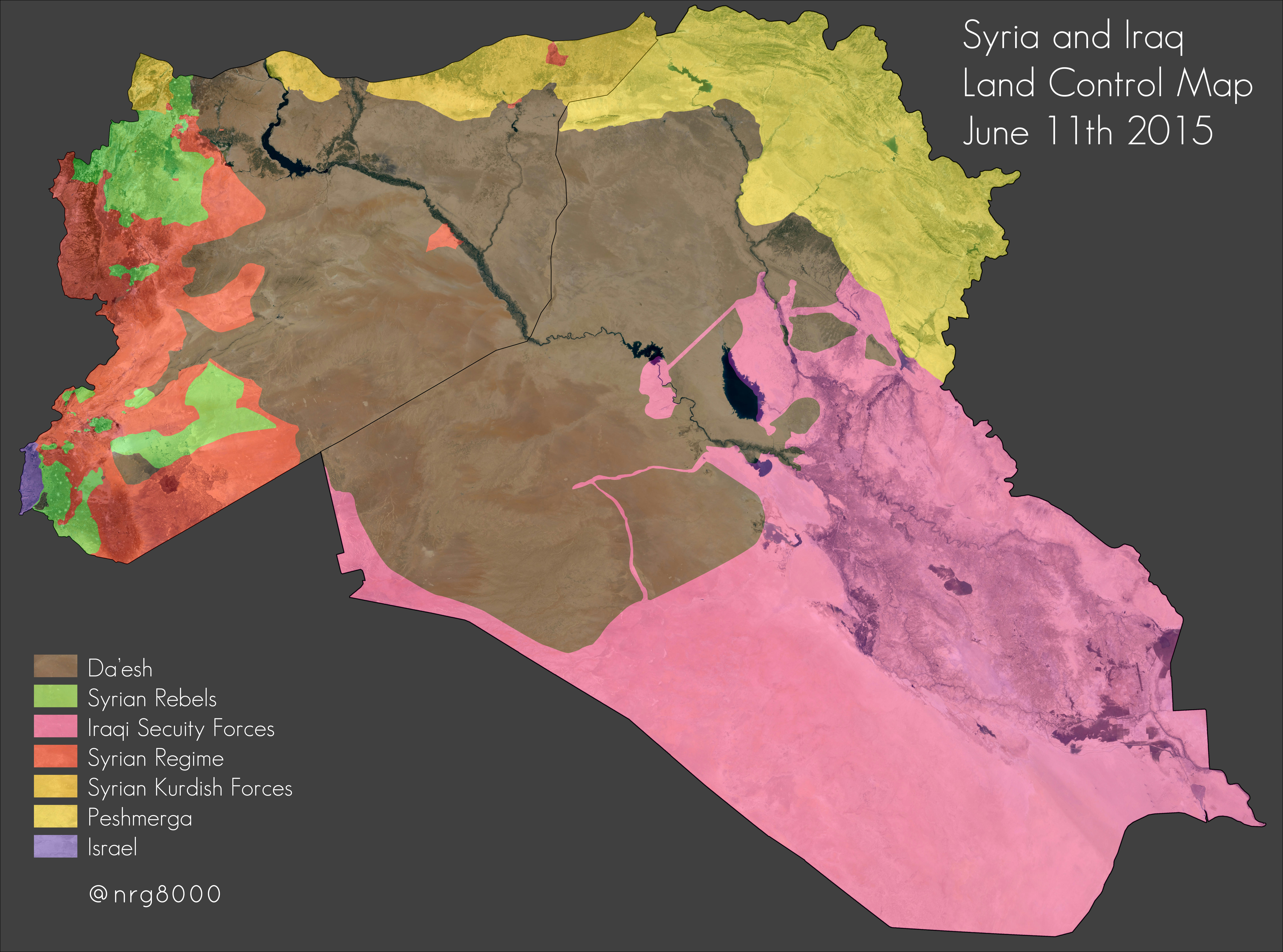
Is the following map by https://twitter.com/nrg8000 reliable?
http://www.mediafire.com/convkey/e5c9/cmbpg9l4uxyv8b0zg.jpg
I need to know if this map can be used to edit in favor of ISF. It shows certain areas near Ramadi as under control of ISF that are not shown as such on our map. I know LightandDark2000 has used it already to edit one town to ISF control, but I need to know if the map is reliable. Is there a way to determine this? Does this user have a bias to any one side? I would think he is pro-ISIS since the areas near Samarra and Muqdadiyah are shown as ISIS-controlled. However, I think the source may have a pro-kurdish bias per this tweet: https://twitter.com/Nrg8000/status/609738929034493952 Pbfreespace3 (talk) 01:41, 14 June 2015 (UTC)
Jalawla
According to this source http://www.thedailybeast.com/articles/2015/06/05/the-kurd-shia-war-behind-the-war-on-isis.html?via=desktop&source=twitter Jalawla is under full control of the Peshmerga. Saeed alaee (talk) 09:05, 10 June 2015 (UTC)
- According to this source and several others, there had been deadly clashes between Kurdish & Shiite militias in Jalawla on 12-13 June 2015. Other sources (https://medium.com/war-is-boring/once-an-islamic-state-stronghold-jalawla-is-now-a-ghost-town-b6c861229014) confirm the presence of Shiite militias in Jalawla.--HCPUNXKID 16:31, 15 June 2015 (UTC)
Is Republic of 3iraaq fully controlling its Diyala Governorate?
I know that the republic claimed that its forces elinimated the Islamic State's Province of Diyala in February 2015, but according to some neutral and pro-Islamic State maps, they show there are some pockets of rural control in Diyala by the Islamic State? What's happening in there? In addition, what's happening in Shamaal Baghdaad province(Southern part of Samaara Governorate)? Did Republic of Iraq kicked IS out of Southern part of Samaara province such as Nebai or Dujail?--햄방이 (talk) 04:18, 14 June 2015 (UTC)
- Islamic State has no real 'control' over either of these regions. Its supporters simply like to say that it does to make ISIS territory seem bigger. Some sleeper cells still remain, but they are not anywhere near powerful enough to be shown on a map. Pbfreespace3 (talk) 00:59, 16 June 2015 (UTC)
Color of Hezbollah-controlled areas in Lebanon

A related discussion is currently ongoing concerning the color of Hezbollah-controlled areas in Lebanon. It is argued whether the Lebanese government should be blue and Hezbollah red (like Syrian Ba'athist regime and its allies), or alternatively that Hezbollah should be blue but Lebanese Government as red (arguing that in each country the legitimate government is colored as red on the map). The problem of course arises at the combined regional map in case Lebanese government is colored red - making the Lebanese government and Syrian government forces the same color, while making Hezbollah - a staunch ally of Baathist Syria, into blue; also Hezbollah-controlled areas in Syria and Hezbollah-controlled areas in Lebanon show in different colors (Syria in red together with the Assad forces, but in Lebanon blue). Obviously it creates a complete incoherence with the combined regional war interactive map Template:Syrian, Iraqi and Lebanon Conflicts detailed map, and the regional spillover map which is based on it (right). Please discuss it at Lebanese Insurgency detailed map page.GreyShark (dibra) 18:57, 17 June 2015 (UTC)
Kurdish - ISIS Confrontations
Please update the map. There are a lot of clashes between ISIS and the Kurdish forces.
See here:
- http://rudaw.net/english/kurdistan/150620152 (In Kazhir)
- http://rudaw.net/english/kurdistan/140620155 (In Bashik near Mosul)
- http://rudaw.net/english/kurdistan/140620153 (In Kifri)
- http://rudaw.net/english/kurdistan/130620151 (Makhmour)
- http://rudaw.net/english/kurdistan/11062015 (South of Kirkuk)
- http://rudaw.net/english/kurdistan/170620153 (Kurdish minister talking about fights around Kirkuk)
- I changed the Makhmour to clashes; the source you gave for kifri does not say there are clashes and the other towns kazhir and bashik are not on the map (atleast not with this name) also i'm not sure what to do with the clashes in kirkuk, can't simply put kirkuk on contested. Could you also end your posts with 4 times ~ this way we can see who made the post and when it was made so it's easier to manage. Cheers. Spenk01 (talk) 02:30, 18 June 2015 (UTC)
Sorry, I'll do that next time. Just forgot it. :) Bashik is Bashiqa on the map. It's about north-east of Mosul. Makhmour is again just yellow. But just this morning the allied airforce attacked ISIS there. Peshmerga and ISIS are fighting around the city. Thanks! :)--Asenger (talk) 16:42, 18 June 2015 (UTC)
- It seems like because the article was talking about 'the bases around makhmour' (the syrian civil war and iraqi civil war maps are being taken over by heavily biased kurds who will bite you if you make a mistake),i took a better look at the sources and the source with Bashik is talking about artillery which are not clashes.And According to the kazhir source it was a convoy of vehicles which was destroyed which also does not say clashes. Rudaw also isn't clear about where these clashes are they are rather talking about 'bases' around these fronts. I'm sorry that's all i could do for you Spenk01 (talk) 20:04, 18 June 2015 (UTC)
No need for being sorry. Thank you for your help! It's fine how it is.--Asenger (talk) 20:49, 18 June 2015 (UTC)
Sources needed
Hey 햄방이, could you elaborate/provide sources on your 4 recent edits - the source you provided does not support, or even mention, any of the edits you made.. Boredwhytekid (talk) 16:30, 19 June 2015 (UTC)
- I changed Habbaniya, Khalidiya, Shihabi into dots showing contested situation and I added Ṣafrah because those are mentioned in here.link --햄방이 (talk) 16:42, 19 June 2015 (UTC)
- My mistake. I used an incorrect link. Sorry to bother you, and thank you. Boredwhytekid (talk) 16:53, 19 June 2015 (UTC)
Semi-protected edit request on 30 May 2015
This edit request to Module:Iraqi insurgency detailed map has been answered. Set the |answered= or |ans= parameter to no to reactivate your request. |
Please remove black semicircle al-Muthanna Chemical Weapons Facility. The facility was besieged by IS, but the siege was broken by government forces. This source confirms:
https://twitter.com/EjmAlrai/status/604623857731936256 Pbfreespace3 (talk) 16:56, 30 May 2015 (UTC)
Semi-protected edit request on 31 May 2015
This edit request to Module:Iraqi insurgency detailed map has been answered. Set the |answered= or |ans= parameter to no to reactivate your request. |
change Fatha (near Baiji) to government control.
source:
http://www.understandingwar.org/backgrounder/iraq-situation-report-may-28-29-2015 Pbfreespace3 (talk) 04:00, 31 May 2015 (UTC)
Pro ISF bias
Editors are changing the map without any proper sources there is lot of pro ISF bias going on in this thread , Like south Ramadi no one has ever provided a proper source for making those dots red ?
When isis takes over a city we wait for entire world media to report it before changing the map but it comes to ISF we take anyones world like Elijah magnier who is pro ISf and shia militia which you could clearly see in this latest Beiji Edit which has been only reported by elijaj and Al arabiya , Which clashes are still ongoing and the city is contested {Jack6780 (talk) 20:34, 7 June 2015 (UTC))
- latest baiji edit was made by Hanibal using this source: http://edition.cnn.com/2015/06/07/middleeast/iraq-forces-baiji/index.html?sr=twcnnbrk06715iraqforcesbaiji749aStoryPhoto it clearly says CNN. 햄방이 keeps making edits without reporting any sources though. Spenk01 (talk) 00:42, 8 June 2015 (UTC)
Yes and it turns out to be really immature statement from ISF once again , They made few advances but the city still heavily contested (Jack6780 (talk) 05:29, 8 June 2015 (UTC))
- I deeply agree. Many people in here are instantly believing Republic of 3Iraq's statements without any proof. I usually rely on a neutral sources such as Jewish or Sa3udi or non-governmental sources.--햄방이 (talk) 11:43, 8 June 2015 (UTC)
Hello 햄방이. Here is a source proving ISF captured Thar Thar camp. http://understandingwar.org/sites/default/files/iraq%20SITREP%202015-6-05.pdf "ISF repelled an ISIS attack against a 1st Rapid Intervention Division base in Nadhim Thar Thar area, northwest of Fallujah...ISF and the "Popular Mobilization" later advanced toward al-Yabani Bridge, south of Nadhim Thar Thar." Nadhim means camp. ISF controls Thar Thar camp. Pbfreespace3 (talk) 21:24, 8 June 2015 (UTC)
- Thanks for your great information. --햄방이 (talk) 10:04, 9 June 2015 (UTC)
- Evidence and source showing the outskirts of Ramadi under ISF control. These are major changes with no corroborating sources posted. Tgoll774 (talk) 23:13, 25 June 2015 (UTC)
- http://musingsoniraq.blogspot.com/ Shows many changes are not justified especially around Ramadi, the map has been blatantly vandalized and needs to be fixed. I don't have the time to do it all. Tgoll774 (talk) 02:20, 26 June 2015 (UTC)
- Evidence and source showing the outskirts of Ramadi under ISF control. These are major changes with no corroborating sources posted. Tgoll774 (talk) 23:13, 25 June 2015 (UTC)
The town of Anah and villages of al rayhanna and al sagra
The town of Anah has been under IS control since June 2014 and it still is today.
- Yeah this map had a lot of pro-ISF changes with no reliable sources justifying it. Tgoll774 (talk) 01:28, 26 June 2015 (UTC)
- This source reports those towns under ISF control: https://twitter.com/LandonShroder/status/608822471140192256
- Firstly, Anah is marked under ISIS, so i don't understand why you are complaining. Also, if you don't like the map, why not provide a source to show these towns are under ISIS control? It seems like you want to edit in favor of ISIS and are biased, seeing as you NEVER provide ANY reasons or sources for your edits. Pbfreespace3 (talk) 17:55, 26 June 2015 (UTC)
Some twitter guy with 80 followers is your source? what a joke it goes against all the wikipedia rules this guy is unknown and dont have any creditability lots of youre recent edits comes from really unreliable sources, you just messing up this map in big time if you have a beef against isis take it somewhere else , we are here to record history not favor someone {Jack6780 (talk) 23:44, 26 June 2015 (UTC))
Iraqi army freed Baiji
Why hasn't anyone updated the map? source 109.110.115.243 (talk) 11:48, 7 June 2015 (UTC)
https://twitter.com/cap_fall/status/607610631194308608/photo/1 Pro-IS says otherwise. The last time ISF said Baiji was liberated it was not and I posted repeated video evidence for three weeks it was not. The proof ISF offered is old videos and Nasheeds. Tgoll774 (talk) 21:20, 7 June 2015 (UTC)
- Proof that Baiji is under ISF control. I see no evidence of it. Tgoll774 (talk) 23:09, 25 June 2015 (UTC)
- Baiji is still heavily contested per reports by Joel Wing, a renowned Iraq Expert since 2009. http://musingsoniraq.blogspot.com/ and on this article he provides the Iraqi Sources that show the city heavily contested. Baiji must go contested, ISF press releases are not credible. Tgoll774 (talk) 11:22, 26 June 2015 (UTC)
- Still no proof Baiji under ISF control, it needs to go to contestedTgoll774 (talk) 19:44, 28 June 2015 (UTC)
- http://www.eurasiareview.com/27062015-why-is-islamic-state-a-master-of-tactical-defeats-oped/ As I thought, Baiji is still being fought over. Tgoll774 (talk) 17:05, 29 June 2015 (UTC)
- http://www.ibtimes.com/iraqi-government-forces-take-control-baiji-oil-refinery-1988773 Prohibited Area (talk) 14:20, 30 June 2015 (UTC)
- Baiji is still heavily contested per reports by Joel Wing, a renowned Iraq Expert since 2009. http://musingsoniraq.blogspot.com/ and on this article he provides the Iraqi Sources that show the city heavily contested. Baiji must go contested, ISF press releases are not credible. Tgoll774 (talk) 11:22, 26 June 2015 (UTC)
User:LightandDark2000, please engage on the discussion page before making edits. Arbitrarily making mass edits is not how Wikipedia works; it is a joint venture. Your recent edits on this module fly in the face of the elementary rules of editing. This edit cited a source that doesn't even mention the town you edited. This edit you cited an Iranian source and a source that is just reiterating the central goverment's claims to edit an ISF advance (we don't use pro-X sources for pro-X edits/advances, for any side). This edit you just cited an amateur map and some twitter account. Please self-revert the above, as none of them conform to the rules governing usable sources. I refer you to this discussion, where the community tried to engage with you, and to this message from the modules' creator.Boredwhytekid (talk) 13:24, 26 June 2015 (UTC)
- Stharkov, NightShadeAEB, DuckZz, Rhocagil, Pbfreespace3, Tradedia, anyone else who might care.. Boredwhytekid (talk) 13:29, 26 June 2015 (UTC)
- Boredwhytekid it's is only his POV pushing just like the edits he makes on the syrian civil war template,He changed all places and neighborhoods of Ramadi,and it looks more likely like an offensive which no one reliable source mention it.PapaDock547 (talk) 19:56, 26 June 2015 (UTC) — PapaDock547 (talk • contribs) is a confirmed sockpuppet of Lindi29 (talk • contribs).
- I'd like to believe that we can have constructive dialogue and work together to make the map as accurate as possible; and I assume in good faith that User:LightandDark2000 is editing in the same spirit. That being said, PapaDock547, since you've taken an interest, would you mind terribly reverting one of the unjustified edits listed above? I have already used a revert today. *I am in no way advocating edit warring in any sense, and if you are not comfortable with my suggestion I retract and apologize in advance. Boredwhytekid (talk) 20:20, 26 June 2015 (UTC)
- Boredwhytekid the fact that the user uses unknown twitter accounts and not disscusing it first I would have revert him but I still dont have access editing on semi-protected pages.PapaDock547 (talk) 09:22, 27 June 2015 (UTC) — PapaDock547 (talk • contribs) is a confirmed sockpuppet of Lindi29 (talk • contribs).
- Its going to take a lot of research to figure out what places should revert due to the massive unjustified edits. Especially around Ramadi as no offensives have occurred there, all the fighting is around Fallujah so those outlying Suburbs of Ramadi need to go back to IS control as the last reliable sources we have show them under IS control. Tgoll774 (talk) 11:35, 27 June 2015 (UTC)
- Boredwhytekid the fact that the user uses unknown twitter accounts and not disscusing it first I would have revert him but I still dont have access editing on semi-protected pages.PapaDock547 (talk) 09:22, 27 June 2015 (UTC) — PapaDock547 (talk • contribs) is a confirmed sockpuppet of Lindi29 (talk • contribs).
LightandDark2000 RUINING THIS MAP
Am shocked to see so many mistakes in this map and its all because of this two editors who are ruining this map entirely and their edits are far from reality
Few examples are like town of anah albu nimr and ramadi sorroundings which has edited by looking just at some tweets with people who has less followers than 90 , They look like Anti ISIS , But guys we are here to record history and changing dots in this map not gonna change reality on the ground , We have strict rules here in wikipedia to edit this map Like Source should be Neutral and well known
I request someone to do something about this absurd editors or delete this map entirely {Jack6780 (talk) 01:08, 1 July 2015 (UTC)}
P.S Guys am going to propose this page for deletion if we didnt able to find any solution regadring this editors , Thought?
Ask Magog the Ogre to page protect it for the time being and do a full source audit to correct the map then we can get back to user edits but under tighter scrutiny. Tgoll774 (talk) 03:16, 1 July 2015 (UTC)
problem is not with this two editors the problems is with the other editors who are choosing to ignore this before Edits like this wouldn't even survive for an hour now people are taking this as fact i hope somebody concern will do something about it {Jack6780 (talk) 04:26, 1 July 2015 (UTC)}
- If they're causing a problem, consider getting an uninvolved administrator, per the general sanctions:
- "After being notified of the sanctions, any editor who repeatedly or seriously fails to edit in accordance with the purpose of Wikipedia, the expected standards of behaviour, or any normal editorial process may be sanctioned by any uninvolved administrator. Sanctions may include blocks for up to one year, page bans, and topic bans." Banak (talk) 13:35, 1 July 2015 (UTC)
- I am pbfreespace3. I didn't edit any towns near Ramadi to Government control. In fact, I edited some to contested *from* government control. Also I fully understand how incompetent the Iraqi Army is, so don't say I have a pro-ISF bias in my editing. I have also added many important towns and villages to this map along the Tigris and near Haditha and Mosul, all ISIS villages. I never added a ISF-controlled village: just look at my edit history. Now the Syria Map has been locked because of some bad edits, and the map is frozen in time! I think it is far better to have a good map with some errors rather than no map at all. Pbfreespace3 (talk) 15:55, 1 July 2015 (UTC)
- Trying to stem the tide.. in situations as listed above where edits are made based off of random twitter accounts and the like. 1RR makes that kinda difficult though. Not sure what's up with the shade being thrown at Pbfreespace3 though - this editor actually will engage in conversation and discuss sources/the most accurate information if you simply reach out.. Boredwhytekid (talk) 19:02, 2 July 2015 (UTC)
Agreed checked Pbfreespace3 last week edits sources seems to be pretty reliable my bad confused him with some other editor who is making lot of pro ISF and pro Kurdish edits without any good sources
Sinjar Contested?
Pbfreespace3Can you please provide the source for putting sinjar back to contested ? The Vice documentary Hosted by Aris Russious didnt claim the peshmerga are inside sinjar it mentioned they are in the outskirts of the town guarding the mountain and offensive on sinjar only possible when they receive heavy weapons . And the rules of this thread are you cant put any city to contested until active battle is going on or the opposite group hold a good enough territory inside the city.
Having said that documentary is around three months old where my source is from last week articles from the sinjar front-lines {Jack6780 (talk) 01:24, 4 July 2015 (UTC)}
- I'm pretty sure Sinjar town is still contested. Even writing off the Vice documentary from a while back, PeterClifford, News-soft from 5 days ago, al-Monitor (relevant source, but not directly), and France24 - all still indicate contested. Also the source you posted, Basnews, seems to just confirm that the situation is Sinjar has remained stalemated - not that the front line has moved. "Two women from the YPJ tell us that they have been in Sinjar for 45 days." "He’s been in Sinjar for eight months.." I read that as the front line remains the same, with the Kurdish forces holding a foothold in the northern section of the town, as they have for months, and the IS still retaining the majority of it. Boredwhytekid (talk) 13:35, 4 July 2015 (UTC)
Samra village near Tikrit marked black
The latest news about Samra village near Tikrit is this [2], a Kurdish source from March saying that the village was liberated by Iraqi forces. Should I change it to red or did I miss something? --Ahmetyal (talk) 14:32, 4 July 2015 (UTC)
- That source was originally used to add Samra village, here, but a few days later the same editor provided an alternate source and edited Samra to IS held, here, as it has remained since. Boredwhytekid (talk) 14:02, 5 July 2015 (UTC)
Kirkuk
Why are some areas in south Kirkuk circled by isis? Battles were reported in this areas and isis was completely defended and kicked out from the surrounding areas so there was no encirclement.
http://rudaw.net/english/kurdistan/06072015?keyword=Kirkuk
And Atshana and many other villages south of Kirkuk were liberated by Peshmerga.
http://rudaw.net/english/kurdistan/190420152 --Alan Genco (talk) 19:26, 12 July 2015 (UTC)
- We can't use pro-Kurd sources. Only neutral sources are appropriate. Don't even bother using Twitter sources (as I have seen the discussion, assuming they are not allowed.) Copying from maps is a big no-no. BTW, if there is a pro-gov (even Kurd related) source, then it can be used only for ISIS gains, or for pro-ISIS sources, then gov gains. The Twitter that I mentioned, if you want to show to other editors and talk about it, then please do so on the talk page, since we can have a debate about it. --Damirgraffiti |☺What's Up?☺ 19:54, 12 July 2015 (UTC)
What are you talking about check most of the sources used for iraqi gains are pro iraqi sources.
You must use local sources because they give most of the details. International sources just report about big cities but not about villages but this map is full of villages.
The villages south of Kirkuk were yellow after the Peshmerga offensive. Even international media reported about Peshmerga gains. But somebody changed the villages to black without giving any source.
http://uk.mobile.reuters.com/article/idUKKBN0M50J220150309?irpc=932
http://m.liveleak.com/view?i=b5e_1425933802
According to you logic you can not change the villages to black without giving non isis sources.--Alan Genco (talk) 11:45, 13 July 2015 (UTC)
fulljah
i found a account on twitter its called iraq live update it talks about fulljah and battles and places isis lost please respond and check it out and also another account i found it called iraqisecurityGmoney293 (talk) 20:14, 13 July 2015 (UTC)
Sources for the major changes on the map
Guys, we have what appears to be two major offensives against KRG towards Erbil and Kirkuk, and ISF offensive around Fallujah. Please post your sources here. Tgoll774 (talk) 12:38, 9 July 2015 (UTC)
Pbfreespace3, we have had no less than several Admins state that twitter sources are generally not allowable anymore without serious vetting. Your revert of Saqlawqiya based solely on Twitter posts of Elijah Magnier is a violation of the sourcing rules. Undo your revert. Also ISW is not to be generally trusted as it just restates what ISF says and we know ISF is untrustworthy as a source. And I'm not pro-Any damn thing. If I were pro-IS the FBI would have me in the dock. However, I do want the map to be accurate. That goes for everyone, stop sling pro this and that charges. One can respect and truthfully report IS progress and still utterly despise them. Tgoll774 (talk) 20:54, 9 July 2015 (UTC)
- Without Twitter reports (from reliable sources) and without ISW reports, this Iraqi map would be basically useless; you can't compare this map to the Syrian one, the Syrian war progress is much more monitored than the Iraqi war. About ISW, it always states if the reports published are "unconfirmed", and imho it is still the best source for updating the Iraqi map. --8fra0 (talk) 22:13, 9 July 2015 (UTC)
- We still can find better than Twitter and ISW. Its a matter of searching. But straight up use of Twitter and ISW without vetting is not allowed. What you do is you post it in the talk page and ask others to assist in finding main stream reports to back it up. Tgoll774 (talk) 11:43, 10 July 2015 (UTC)
- Tgoll774 is correct. Accuracy is more important than speed. Twitter reports generally need to be supported by at least a second source. It's better to post on the talk page and enlist the combined efforts of all editors than to make mass edits based on 1, questionable source. Why is this so difficult? If you've found a source claiming an edit needs to be made, what's so difficult about posting it here so everyone can assist in corroborating or refuting? Again, it's about accuracy.. Boredwhytekid (talk) 12:47, 10 July 2015 (UTC)
- Twitter is a platform, not a media outlet. Not necessarily a news published on twitter is more reliable than one published in a proper website, or vice-versa. For istance in the Syrian map page a (proved) unreliable news outlet, Aranews, has been used for major editings lately, without anybody complaining; and meanwhile some more reliable Twitter sources have been reverted without any reason, just because "it's Twitter". --8fra0 (talk) 14:48, 10 July 2015 (UTC)
- Tgoll774 is correct. Accuracy is more important than speed. Twitter reports generally need to be supported by at least a second source. It's better to post on the talk page and enlist the combined efforts of all editors than to make mass edits based on 1, questionable source. Why is this so difficult? If you've found a source claiming an edit needs to be made, what's so difficult about posting it here so everyone can assist in corroborating or refuting? Again, it's about accuracy.. Boredwhytekid (talk) 12:47, 10 July 2015 (UTC)
- We still can find better than Twitter and ISW. Its a matter of searching. But straight up use of Twitter and ISW without vetting is not allowed. What you do is you post it in the talk page and ask others to assist in finding main stream reports to back it up. Tgoll774 (talk) 11:43, 10 July 2015 (UTC)
- ISW confirms ISF advance in Saqlawiyah, I've edited it as contested but every report available says that it's fallen in ISF hands. Also Brigade 30 should be edited, as ISF have advance till Al-Ghaynan and Al-Sajar. --8fra0 (talk) 06:40, 11 July 2015 (UTC)
Ramadi contested?
Multiple sources, like this, and this are saying that IS destroyed the booby-trapped Ramadi stadium after it was recaptured by Iraqi forces. As the stadium is well inside Ramadi city (not far from the center) here: http://wikimapia.org/#lang=en&lat=33.420625&lon=43.321753&z=14&m=b&search=ramadi%20stadium I think the the city's status should be changed to contested. --8fra0 (talk) 14:47, 21 July 2015 (UTC)
- As I recall, the stadium was used as an ISF base (according to ISIS, probably what's more likely is they hate soccer and sports) and they blew it up to prevent ISF from using it in the future. I think we'll know when ISF forces re-enter Ramadi, as it will be widely reported in international news media. Pbfreespace3 (talk) 18:54, 23 July 2015 (UTC)
- http://anbardaily.blogspot.com/2015/07/22-july-2015.html This keeps a log of announcements. Basically ISF is saying they captured stuff before they actually have. Half of the red dots in Anbar are actually still contested or under still under IS control. By all indpendent accounts, Anbar is 80% controlled by IS. Tgoll774 (talk) 22:42, 23 July 2015 (UTC)
- You could at least try to hide your pro-ISIS bias, but instead you're letting it hang out. You provide no source to back up your claim that ISIS controls 80% of Anbar. I even added ISIS-held villages that were not present on the map before, although the Syria and Iraq template map has not updated yet for some reason. I guess there is a time delay. Is this happening for you too?
- Tgoll774, The fact is that although ISF has not entered Ramadi city, they are surrounding it and they will enter the city within a week or 2. I recently updated the Ramadi area according to a source that you can find on the edit history page, switching some areas to ISF and others to ISIS. The Ramadi area has been underreported, but now it is fixed. Pbfreespace3 (talk) 00:02, 24 July 2015 (UTC)
Zawiya
ISIL completely leveled the village of Zawiya, after its residents refused to fight for ISIL. So should I delete the icon for the village, or leave it as it is? LightandDark2000 (talk) 07:03, 1 August 2015 (UTC)
- LightandDark2000 Interesting. I'm not totally convinced as to the reliability of the source, and I'm hesitant to say the village should be removed from the map. I will have to remember to look at this town in the future on updated satellite maps. However, I think a small size decrease of the town on the map is a good compromise, so I'll do that. Pbfreespace3 (talk) 00:42, 5 August 2015 (UTC)
rudaw is a kurdish propaganda, not a reliable source majority of its stories no basis in reality whatsoever
Map size
I think this map is not good because of it`s size. It is very difficult to find the accurate location, Have a look at Ramadi, Fallujah and their neighbourhoods. Can`t someone manage it? MyNameIsHIMMU (talk) 13:28, 19 August 2015 (UTC)
Brigade 47 near Kerkuk
It is military base but it is marked as village on the map.
- No, it's marked as a base. Pbfreespace3 (talk) 00:42, 13 September 2015 (UTC)
Peshmerga Forces Attack Hawija?
https://twitter.com/search?q=%23hawija&src=typd
Reports Peshmerga might soon attack Hawija. I am waiting for more reliable sources. Pbfreespace3 (talk) 01:00, 30 September 2015 (UTC)
First, a pro-ISIS source claimed US troops were accompanying Peshmerga forces near Kirkuk. I don't believe him, as most of the rest of his reports are false as well. https://twitter.com/RamiAlLolah/status/648981562923610112
Second, others reported heavy US airstrikes near Hawija: https://twitter.com/stevoiraq/status/648972143598800896 https://twitter.com/Sarbarzi/status/648994895148003328
Then, pro-Kurdish sources said there was a massive ground attack near Hawija: https://twitter.com/hhazhan/status/648997366427746308 https://twitter.com/MevanAkreyi/status/649006628801347584
An FSA supporter also backs this up: https://twitter.com/F1ea1337/status/649010321340899329
Will make updates when territorial gains are made. Pbfreespace3 (talk) 01:39, 30 September 2015 (UTC)
Peshmerga Forces liberated dozens villages in Kirkuk
I want update map but i don't know village names.. Please update this map— Preceding unsigned comment added by 109.29.141.10 (talk • contribs) 17:59, 30 September 2015 UTC
- If you have reliable sources that mention the attack, I imagine they will also mention the name of the villages involved. Banak (talk) 20:17, 30 September 2015 (UTC)
New Iraqi gains in Ramadi
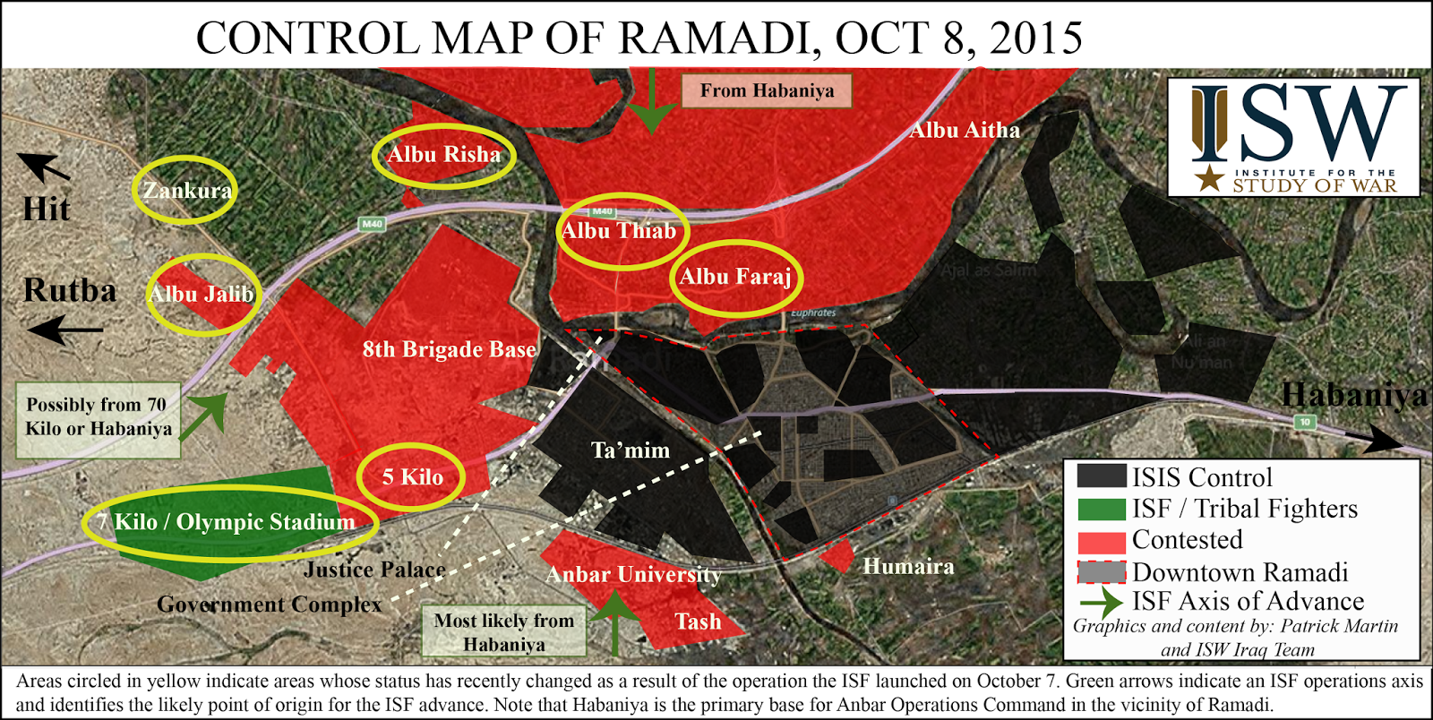
Seems Iraqi forces have gained some ground in Ramadi per: http://news.yahoo.com/iraq-forces-retake-areas-around-ramadi-114949373.html. Just to show something at least.--Damirgraffiti |☺What's Up?☺ 20:29, 7 October 2015 (UTC)
- Damirgraffiti here is the map that show the situation of Ramadi.46.99.7.138 (talk) 15:02, 9 October 2015 (UTC)
- These maps from ISW have been considered unreliable in the past, and I also have a pro-Iraqi Shia source that makes claims contrary to what this ISW map says. According to his map from October 8, ISIS still controls Albu Jalib and ISF is closer to Ramadi from the east than the ISW map says. 73.45.167.247 (talk) 19:05, 10 October 2015 (UTC)
Semi-protected edit request on 14 October 2015
This edit request to Module:Iraqi insurgency detailed map has been answered. Set the |answered= or |ans= parameter to no to reactivate your request. |
As it currently stands, the Islamic State does not have full control over Ramadi, Iraq. As of now, Iraqi forces are advancing into the city and I recommend the black dot representing full Islamic State control over Ramadi be changed the shifting red-black dot representing a contested city. Ninjasquirrell12 (talk) 21:46, 14 October 2015 (UTC)
- Not saying I disagree with your statement, but we need a good source before we change Ramadi to contested. As far as I am aware, there has not been a major Tikrit/Kobani-style push into the city itself. The ISF have only captured the suburbs and outskirts like Albu Faraj, 8th Brigade, etc. and not parts of the city proper. This map from a Shia pro-government individual shows that only ~10% of the city proper is ISF-held. 2601:C7:8303:22DC:1DB4:BFDC:1999:782E (talk) 00:06, 15 October 2015 (UTC)
Semi-protected edit request on 15 October 2015
This edit request to Module:Iraqi insurgency detailed map has been answered. Set the |answered= or |ans= parameter to no to reactivate your request. |
LightandDark2000, Banak, or HCPUNXKID: please change "Tel Abu Jarad" and "Mazraa" to contested between ISF and ISIS, and change "Al Seniyah" and "Asteria" to ISIS-controlled per pro-ISF source [[3]] 2601:C7:8303:22DC:1DB4:BFDC:1999:782E (talk) 00:12, 15 October 2015 (UTC)
 Not done: please provide reliable sources that support the change you want to be made. Mdann52 (talk) 16:52, 4 December 2015 (UTC)
Baiji Refinery
Based on the news, it seems Iraqi forces have taken the refinery per (I have changed the status of the refinery of the map):
--Damirgraffiti |☺What's Up?☺ 21:07, 16 October 2015 (UTC)
- Damirgraffiti, LightandDark2000, a Pro-Government al-Masdar News reports a huge Iraqi advance around Baiji. Leith Fadel claims government forces have taken Makhoul, far north of Baiji. I am skeptical of this claim. The newest Amin Akh (pro-government) map shows a big Iraqi advance as well, supported by reliable news reports here and here. I think the ISIS fighting in Al Mazraa should be shown on our map. 2601:C7:8303:22DC:1DB4:BFDC:1999:782E (talk) 02:08, 17 October 2015 (UTC)
- I will make the update right now. LightandDark2000 (talk) 04:01, 17 October 2015 (UTC)
Reportedly, Iraqi Army and Shiite militias took most of Baiji, in particular the city center and Tamim neighbourhood. "The Islamic State is said to be holed up in just a pocket of the city [..]" [4].Schluppo (talk) 19:47, 20 October 2015 (UTC)
- Another reliable source says here about Baiji being fully taken: http://www.japantimes.co.jp/news/2015/10/21/world/iraq-forces-driven-islamic-state-fighters-key-refinery-town-baiji-baghdad/#.VibGHCsps-Y --Damirgraffiti |☺What's Up?☺ 22:54, 20 October 2015 (UTC)
fuck america
Semi-protected edit request on 10 October 2015
This edit request to Module:Iraqi insurgency detailed map has been answered. Set the |answered= or |ans= parameter to no to reactivate your request. |
Change Albu Jalib and Albu Assaf to ISIS-control per pro-Iraqi source from October 8: http://www.mediafire.com/view/10d563txnlnzdnm https://twitter.com/HKarimi1991/status/652177136212557824 73.45.167.247 (talk) 19:07, 10 October 2015 (UTC)
 Done —Skyllfully (talk | contribs) 19:36, 26 October 2015 (UTC)
Ramadi
According to ISW, ISF have entered into central Ramadi. We can change Ramadi to contested if it's possible.
http://www.understandingwar.org/sites/default/files/iraq%20SITREP%202015-11-02.pdf
--Damirgraffiti |☺What's Up?☺ 01:31, 3 November 2015 (UTC)
Dibis
According to Reuters, Peshmgera have already regained control of Dibis per http://www.reuters.com/article/2015/11/03/us-mideast-crisis-iraq-violence-idUSKCN0SS28X20151103--Damirgraffiti |☺What's Up?☺ 13:15, 5 November 2015 (UTC)
Sinjar
Sinjar is currently under a full siege, and all the areas around Highway 47, from Syria to the outskirts of Tel Afar (at Sinu) are under Peshmerga control.
See [5], [6], [7], [8], [9], [10] for starters. This U.S News article confirms that the road has been cut from both sides. Want more sources? Find them yourselves; there's an entire Internet out there, and stop reverting. LightandDark2000 (talk) 11:27, 12 November 2015 (UTC)
The map has been edited multiple times without using any reliable source. It looks like Peshmerga have advanced to south Sinjar, and this is not the case as many sources report fighting north of the main road, as north as Hardan here, here, here, here. Also a reliable map is provided by De Syracuse here. 8fra0 (talk) 12:07, 12 November 2015 (UTC)
- Most of those sources are outdated in some way. Most maps, even the most accurate ones are not always right, and usually contain a mistake or two. Also, suicide bombs/car attacks do not count as actually contesting villages/towns, as those attacks can happen many miles from an active frontline. LightandDark2000 (talk) 12:11, 12 November 2015 (UTC)
- How can they be outdated if they are updated just a few hours ago? They are of course more updated than your sources which are not neutral, not reliable and also older. So please revert the changes you have made, you have even broken the 1RR rule today. 8fra0 (talk) 12:22, 12 November 2015 (UTC)
- News articles are consistently more reliable than map sources. There are 3 listed above that all corroborate the changes made. The one village that wasn't mentioned I reverted. But the rest has solid proof above. (As for your question, people domake mistakes, and not everyone receives the latest frontline news immediately.) LightandDark2000 (talk) 12:25, 12 November 2015 (UTC)
- This is a wikipedia page, not LightandDark2000 webpage, you have to discuss your editing and you can't break the rules. I asked you like 10 times to provide reliable sources or to revert you editing. NONE of the sources you provided is reliable: "the road from Sinjar to Talafar has been cut" does not mean that you can edit 10 villages between Sinjar to Talafar to Kurdish control. 8fra0 (talk) 12:36, 12 November 2015 (UTC)
- Read the talk header. This is not about me, nor is it a place to discuss my editing patterns. This is a place to discuss issues/ways to improve the article. No one should be calling each other vandals or launching personal attacks. Sources are sources, especially those that are news articles from well-known or reputable outlets. If the article says that an entire length of Highway was captured, then it also means that every village sitting directly on it has been captured as well. BTW, if you are really that impatient, just wait. As time goes on, more articles will be published either proving or disproving what has been stated before. And if things continue to accelerate at the same pace, all of the map sources will fall way behind within a day (esp. if it's true that the US Gov. believes that Sinjar city will fall in 2-4 days, as I saw in a recent post.) There were reliable sources given for the changes; however, so the changes are valid. PS, I just found this CBS News source confirming the reported advances as well. Interestingly, US military officials do expect Sinjar city to fall in just 2-4 days, with another week for "clearing operations." Guess we'll just have to wait and see. LightandDark2000 (talk) 12:49, 12 November 2015 (UTC)
- LightandDark2000, do You really have to ruin Iraqi part of the map to??? You continue to stubbornly misinterpret sources. In this example, You changed Az Zaytuniyah, Zakdah Khan, Hamedan and Alshbabyt to yellow although they are not mentioned in the source. I'm going to revert all your unsourced changes. And I'm not going to waste my time again on checking every fake source You gave! If You think your source has information and it's not so obvious, please post detailed explanation on talk page! --Hogg 22 (talk) 09:29, 13 November 2015 (UTC)
- Read the talk header. This is not about me, nor is it a place to discuss my editing patterns. This is a place to discuss issues/ways to improve the article. No one should be calling each other vandals or launching personal attacks. Sources are sources, especially those that are news articles from well-known or reputable outlets. If the article says that an entire length of Highway was captured, then it also means that every village sitting directly on it has been captured as well. BTW, if you are really that impatient, just wait. As time goes on, more articles will be published either proving or disproving what has been stated before. And if things continue to accelerate at the same pace, all of the map sources will fall way behind within a day (esp. if it's true that the US Gov. believes that Sinjar city will fall in 2-4 days, as I saw in a recent post.) There were reliable sources given for the changes; however, so the changes are valid. PS, I just found this CBS News source confirming the reported advances as well. Interestingly, US military officials do expect Sinjar city to fall in just 2-4 days, with another week for "clearing operations." Guess we'll just have to wait and see. LightandDark2000 (talk) 12:49, 12 November 2015 (UTC)
- This is a wikipedia page, not LightandDark2000 webpage, you have to discuss your editing and you can't break the rules. I asked you like 10 times to provide reliable sources or to revert you editing. NONE of the sources you provided is reliable: "the road from Sinjar to Talafar has been cut" does not mean that you can edit 10 villages between Sinjar to Talafar to Kurdish control. 8fra0 (talk) 12:36, 12 November 2015 (UTC)
- News articles are consistently more reliable than map sources. There are 3 listed above that all corroborate the changes made. The one village that wasn't mentioned I reverted. But the rest has solid proof above. (As for your question, people domake mistakes, and not everyone receives the latest frontline news immediately.) LightandDark2000 (talk) 12:25, 12 November 2015 (UTC)
- How can they be outdated if they are updated just a few hours ago? They are of course more updated than your sources which are not neutral, not reliable and also older. So please revert the changes you have made, you have even broken the 1RR rule today. 8fra0 (talk) 12:22, 12 November 2015 (UTC)
US-led Coalition source has confirmed that the entire Highway 47 segment between Tel Afar and Syria has been cut, thereby isolating Sinjar city. You can't get a more direct/reliable confirmation that that. New York Times has also published an article detailing the capture of Highway 47. LightandDark2000 (talk) 13:05, 12 November 2015 (UTC)
- New EzidiPress report confirms the previously reported advances. It also reports that the Peshmerga has captured the Sinjar Camp, southwest of Sinjar city, and cut the roadways from the south of the camp to the Solagh area, which means that the villages between Jammah and Bashuk have fallen under Peshmerga control. It also reports that the village of Alshshababit has been captured as well. (The article appears to receive live updates periodically as well.) LightandDark2000 (talk) 22:32, 12 November 2015 (UTC)
Misinterpreting sources by user:LightandDark2000
user:LightandDark2000 continues with disruptive edditing, so I'm going to revert his latest edit. In this example, he makes changes with comment "Areas between Sinjar Camp and Solagh have been captured. http://ezidipress.com/blog/stunde-null-in-shingal-liveticker-zur-offensive/", while at the same time painting to yellow quite a lot of villages whose location doesn't really fit description "between Sinjar Camp and Solagh". I would kindly ask user:LightandDark2000 to stop with his disruptive behaviour. I already reported this problem to admin's noticeboard. Let me explain this last edit in more details:
As You can see, this is clearly outside of described Kurdish gains "between Sinjar Camp and Solagh". --Hogg 22 (talk) 15:02, 13 November 2015 (UTC)
Villages south of Sinjar
Many of the villages south of Sinjar are under Kurdish control. They were yellow but someone changed them back to black. For example village of Tall Qassab has since two days been captured by Kurdish forces. See or instance this report by ANHA about rescuing two teenage girls in Tall Qasab: http://www.hawarnews.com/%D8%AA%D8%AD%D8%B1%D9%8A%D8%B1-%D9%81%D8%AA%D8%A7%D8%AA%D9%8A%D9%86-%D9%85%D9%86-%D9%8A%D8%AF-%D8%A7%D9%84%D9%85%D8%B1%D8%AA%D8%B2%D9%82%D8%A9/ Roboskiye (talk) 15:02, 14 November 2015 (UTC)
- They were changed to yellow before they were any news about their liberation, and that wasn't the first time this user did that. If You have a reliable source now, please change the map. --Hogg 22 (talk) 07:43, 15 November 2015 (UTC)
IS still on Dyala-Salahuddin border?
It seems that the government wasn't able till now to clear the area of al-Adhaim and the mountain-chain of Hamrin: http://altaghier.tv/2015/12/15/مصادر-عسكرية-القوات-الأمنية-المشتركة
And I even doubt that the area is really clear. Maybe to put a black grid somewhere there to show IS presence. Mughira1395 (talk) 00:32, 16 December 2015 (UTC)
Update: Maybe it is related to tehe aforementioned: Dozens of mortar-rounds fired on three villages just north of Muqdadiya (al-Bumusa, al-Asiyud, al-Lahaybat): http://altaghier.tv/2015/12/16/مجهولون-يمطرون-المقدادية-بعشرات-قذائ
Mughira1395 (talk) 13:33, 16 December 2015 (UTC)
Albu Dhiyab (north of Ramadi)
I know, that nobody is working here, but maybe somebody shows some mercy ;-)
According to this article, Abu Dhiyab is still to be liberated. So it had to be black before and now contested: http://altaghier.tv/2015/12/20/قائد-عمليات-محافظة-الانبار-يعلن-بدء-تح It says that the commander of Anbar liberation operation commander, Brigadier-General Ismail al-Mahlawi announced the beginn of operations to liberate Albu Dhiyab, and that advance is going fast and without resistance. Mughira1395 (talk) 13:28, 20 December 2015 (UTC)
Map overcrowded
I think the map is too crowded on some areas like Ramadi and Fallujah. Industrial plants and districts (which are part of Ramadi) are all individually marked at the cost of the clarity of the map. It has become so overcrowded that i can't even see Ramadi is contested.
I suggest removing all districts/industrial plants/small towns overlapping Ramadi and Fallujah to bring back the clarity of the map. Spenk01 (talk) 01:26, 23 December 2015 (UTC)
- Or making a image map underneath it, like in case of Aleppo (see Template:Syrian Civil War detailed map). --Hogg 22 (talk) 09:13, 23 December 2015 (UTC)
Kirkuk - Tikrit Road - what settlements lie on it?
[11] Yesterday, IS captured the main road connecting Kirkuk to Tikrit. What settlements lie on it? They are presumably all IS now according to the source. If we could put the road on the map, we would know what was now controlled by IS and what was not in that area of Iraq. PutItOnAMap (talk) 11:52, 15 January 2016 (UTC)
Jalawla
Shiite Militia and Iraqi army does control Jalawla, not Peshmerga.
- No, that's not true. Jalawla is liberated by Peshmerga since 2014 source And now town is controlled by Peshmerga. Bruskom talk to me 18:28, 20 January 2016 (UTC)
Semi-protected edit request on 25 January 2016
This edit request to Module:Iraqi insurgency detailed map has been answered. Set the |answered= or |ans= parameter to no to reactivate your request. |
In the map key, it reads: Gota07.svg Oil/gaz Spellcheck gaz -> gas Johnnyboyz25 (talk) 17:44, 25 January 2016 (UTC)
- Done -- The Voidwalker Discuss 18:40, 13 February 2016 (UTC)
Khalidiyah edit
What is with this edit? Where in this source does it mention Malahameh, Baaran, or Madhiq? None of these places are mentioned at all! Ok, so a road was reopened. Does that automatically mean that all ISIS positions between Ramadi and Fallujah are now under full ISF control? Of course not! That's ridiculous! You should revert your edit immediately, LightandDark2000.
- The source reports that the Khalidiya District has been entirely recaptured. The Khalidiya District includes the Khalidiya Island area, which according to Iraqi sources, encompasses the area between the villages of Albu Nimr and Albu Shajal (which includes all 3 of the villages changed). LightandDark2000 (talk) 07:50, 14 February 2016 (UTC)
Kirkuk Frontline
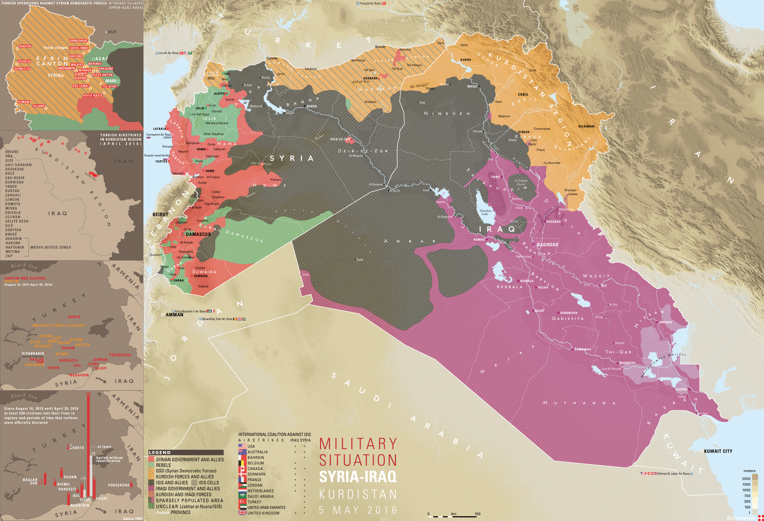
The Kirkuk frontline is slightly different from what our Iraqi map currently shows. According to this map from renowned mapmaker and source LCarabinier, ISIS holds many towns and villages directly south of Bashir that are marked as Peshmerga-held on our map. His map was posted nine days ago, so it is fairly new. Perhaps this should be fixed? Specifically, villages such as Bur Ghun, Yurghun, Sutiyah, Safhal, Qaryat as Sakhul, Sayyid Hassun, Tal Hamr, and Mulla Nasr are all marked as ISIS held on LCarabinier's map, but Kurdish held on ours. Also, a Google search will show that the Peshmerga have not gained several towns or launched on offensive near Kirkuk in the past 10 days. So wouldn't the best assumption be that according to this map from a reliable source, ISIS most likely holds these villages? 2601:C7:8301:8D74:1DB4:BFDC:1999:782E (talk) 03:17, 28 February 2016 (UTC)
- The Peshmerga captured 62+ villages in the exact same region last October [12], which happens to include all of the villages in question and more. Also, the Iraqi Army captured areas west of the river, while the Peshmerga captured the areas east of the river (even though ISIL recently recaptured Kirkuk's Rashaad village from the Iraqi Army). Also, Mao sources are not as accurate as articles, and those maps have been referred as not being reliable enough to use here. Aside from that, while we can reference reliable map sources, we cannot copy the status of villages from map sources, due ti the fact that no map source is 100% accurate, among other problems. LightandDark2000 (talk) 06:58, 28 February 2016 (UTC)
- LightandDark2000 stop lying such rule doesn't apply here,also in the past you used this source and label it as pro-Isis just to vandalise the map.Lists129 (talk) 13:21, 1 March 2016 (UTC)
Anbar
If someone could provide a bit of clarification, or a little bit better of an explanation as to what the hell this section of this article is saying, it would be appreciated.
http://www.bbc.com/news/world-middle-east-35695683 "Haditha and its nearby dam, about 190km (120 miles) north-west of Baghdad, are in one of the few parts of the mainly Sunni province of Anbar not controlled by IS."
I interpret this as saying that IS controls much more of Anbar than we have labeled. 164.106.171.150 (talk) 15:37, 1 March 2016 (UTC)
- I've found other sources that stated conflicting points. From what I've read, the Iraqi Government apparently controls most of Anbar de facto, but ISIL controls the majority of the populated areas. LightandDark2000 (talk) 04:02, 2 March 2016 (UTC)
Semi-protected edit request on 10 March 2016
This edit request to Module:Iraqi insurgency detailed map has been answered. Set the |answered= or |ans= parameter to no to reactivate your request. |
Badush dam, is under the control of peshmerga, has been for a while. please change thank you 138.44.193.18 (talk) 05:47, 10 March 2016 (UTC)
- Do you have an source ? Kordestani (talk) 15:45, 10 March 2016 (UTC)
From some recent articles I've read, it appears that the Badush Dam is under the control of the Iraqi Gov. or the Peshmerga. See [13], [14], [15], [16]. Interestingly, ISIL blew up the Badush Bridge last April, which is located at the town of Badush, south of the dam, to stop Peshmerga forces from crossing over to the other side. There is also a mountain range that separates the Badush Dam from the town of Badush, which would make this area difficult for ISIL to defend. Also, since the Badush Dam site is very important, especially with a potential collapse of the Mosul Dam in the near future, if the Badush Dam site was still under the control of ISIL, at least one of the sources out there would have reported this. LightandDark2000 (talk) 03:49, 11 March 2016 (UTC)
- There is no Iraqi Government or Iraqi army in north of Mosul. Kordestani (talk) 06:09, 11 March 2016 (UTC)
- The Iraqi Army has a limited presence at Mosul Dam. Other than that, I have no idea of how much influence the Iraqi Government has in the region. LightandDark2000 (talk) 07:56, 11 March 2016 (UTC)
It would have been reported if it was retaken in all likelihood. Until we see a source definitively showing its control is by the Iraqi government, or Iraqi government forces advance so as to leave it far away from IS battle lines for a long period of time, we should leave it as IS controlled.PutItOnAMap (talk) 10:13, 11 March 2016 (UTC)
Marking as answered for now. Please feel free to re-request an edit once consensus is reached. Some more sources wouldn't hurt. EvergreenFir (talk) Please {{re}} 20:22, 11 March 2016 (UTC)
ISIS withdrawal from Rutba
ISIS have reportedly withdrawn from Rutba [17] However the town is not under control of the Iraq Security Forces (as of yet), therefore the town should be labelled as being held by local-forces, indicted by the "Location dot blue.svg" icon which is used on other templates.82.153.107.40 (talk) 17:02, 13 March 2016 (UTC)
It is wrong : https://ia801505.us.archive.org/8/items/1Ra13/1Ra1332016.mp4
Scale
It would be very useful that this map had a scale in kilometers and miles. Many news says that a force is to x kilometers from a city. Thank you.Nerêo (talk) 16:12, 26 March 2016 (UTC)
Ezidi militias and Peshmerga conquered at least five villages near Shengal/Sinjar
Hello,
I already wrote this under the Module talk of the Syrian, Iraqi, and Lebanese insurgencies detailed map, since I didn't knew this one. But there weren't reactions, so I try it here, because this is the real base were things around the Iraqi Insurgency are changed.
I just wanted to report that the kurdish troops in Iraq conquered at least five villages near Sinjar the last few days. If I knew the name of the villages and how to edit the Module, I would do it but sadly I don't know so far. The sources: http://www.nrttv.com/EN/Details.aspx?Jimare=4085 http://www.euronews.com/2016/03/25/isil-suffers-series-of-blows-in-iraq-and-syria/
And another thing: I've read that the name of some of these villages are Umecris, Mediban, Zeyban (near Baaj). Sadly the source it not really reliable (it's a newspage on the events around the Kurds and Daesh on facebook), furthermore I couldn't even find them on Google Maps.--Ermanarich (talk) 17:19, 29 March 2016 (UTC)
Southern Arbil
For some reason Southern Arbil is painted as being liberated by Kurdish forces, however this is not the case. Here is a look at how the front looks like MAP. editing it will be very helpful for the future operation to liberate Mosul as the Iraqi forces are now involved in the area. 24.53.229.121 (talk) 18:28, 31 March 2016 (UTC)
- I agree, the map should be edited accordingly to your source. KRG has never controlled the whole Arbil province and is trying to help Iraqi forces to get rid of ISIS there. 8fra0 (talk) 19:15, 11 April 2016 (UTC)
Clashes in Iran between kurdish forces and the Iranian army near the border of Iraq
Hello mappers,
there are reports ([18]) about clashes between Kurdish forces (either from the Kurdish Democratic Party of Iran or from the PKK-linked PJAK) and the Iranian army in villages near the town Sardasht in Iran near the border to Iraq. Shall we maybe add this situation to the map? Similiar things have already been done in the Template:Yemeni Civil War detailed map, where some Saudi-Arabian border towns are also included into the map.
What are your opinions?--Ermanarich (talk) 22:57, 4 May 2016 (UTC)
Great Source on Daesh activities
Hello,
although I didn't get any comments in the talk page here, I hope that some editors read my comments. While researching for the situation in some villages northeast of Mossul I discovered a great page on Daesh/ISIL activities in Iraq.
http://www.daeshdaily.com/2016/04/
I was first a bit confused because of the name, but it's definitely not pro-ISIL. The updates are made on a daily basis and are very detailed.--Ermanarich (talk) 12:27, 5 May 2016 (UTC)
Vandalism southeast of Mosul
So according to the user with the cyrillic name, Daish controls several villages northeast of Gwer? Reliable source lcarabinier reports that Peshmerga controls these villages, not Daish. The vandal with the turk name added these villages as kurd-held, and now russian vandal changes them all to Daish. If I add small villages east of Kirkuk with no source, will he change them to Daish-held? This is crazy, he should be reverted.
source here https://imagopyrenaei.files.wordpress.com/2016/05/5m-syria-iraq-kurdistan.png
No, it was me who edited it, after this source (http://rudaw.net/english/middleeast/iraq/040520161), which is definitely reliable since it's a kurdish newspage and the article is based on an interview with a Peshmerga official
But if Abu Sheeth village in the articles below is the same as Abu Shitah in the article before, the Rudaw article may just have a translation error: http://www.daeshdaily.com/may-4-2016/ http://www.daeshdaily.com/may-3-2016/ If so, I would change the colours there back to yellow. What do you (who ever wrote it, since there is no signature) think?--Ermanarich (talk) 12:16, 7 May 2016 (UTC)
What I should also mention: Maps do not count as sources for the Wikipedia map in any way!--Ermanarich (talk) 12:17, 7 May 2016 (UTC)
It would be good to discuss it out what we can do with the villages around Abu Shitah. I'm pretty sure that it's the same village as Abu Sheeth, which means that it's in the hands of Peshmerga.
However, it's sure that the village has been attacked by ISIL-militants. That's problematic, because the area around Abu Shitah is isolated from the other territory held by Daesh, since it's east of the Zab river and the bridge in Gwer is definitely held by the Peshmerga, as well as the bridges further to the north.
This means, that ISIL must have some positions near Abu Shitah.
How can we show this on the map, since we don't know them?--Ermanarich (talk) 20:09, 8 May 2016 (UTC)
Kata'eb al-Mosul
Hello,
There seems to be a paramilitary underground organisation called Kata'eb al-Mosul operating in sabotage actions and assassinations against Daesh in Mosul: http://www.daeshdaily.com/may-13-2016/ (and there are actually almost daily mentions about attacks from them at this page)
I think I'll create an article about them soon, but how would you show them on the map? It think to mark Mosul as contested would be highly exaggerated. But do we have other options to show them?--Ermanarich (talk) 14:17, 14 May 2016 (UTC)
- Idon't think it's worth mentioning. Daish controls all of the city and surroundings, so it would be like trying to show rebel presence in al-Mayadin or Raqqa in Syria, for example. In any city taken by group like Daish, there will be underground organizations. It would be different if they seize control of several neighborhoods like Polish Home Army did in Warsaw in 1944, but that has not happened here. If it does, you can mark Mosul as contested.
Tuz Khurmatu & Bashir
Both Tuz Khurmatu and Bashir should be changed to joint yellow/red. Tuz Khurmatu is controlled by local pro-Peshmerge and pro-Iraqi militia/police. Bashir is controlled by Peshmerge and Hashd. But in recent hours large numbers of Hashd are withdrowing from Bashir towards baghdad. Roboskiye (talk) 10:53, 17 May 2016 (UTC)
Mosul village taken, should be marked on map
National Mobilization seize village from Daish near Mosul: https://twitter.com/LCarabinier/status/731549627175043072
Thanks!--Ermanarich (talk) 23:35, 14 May 2016 (UTC)
- The question is if they are keeping control of it, or giving the village to Peshmerga. Kanuni is a Yazidi Kurdish village. The only reason for them being at this front is to train them, so they later can participate in the Mosul offensive. So if any of you can find a source about who controls it, please share. --Ahmedo Semsurî (talk) 21:11, 16 May 2016 (UTC)
It's actually a Shabak and not a Yazidi village. But there is a interesting comment in the new Daeshdaily report. (http://www.daeshdaily.com/may-16-2016/):
"A Shabak MP says the National Mobilization Forces attacked a Shabak village in Bashiqa, supported by Peshmerga, Turkish troops, and Coalition warplanes, starting early morning on Sunday and withdrawing in the afternoon. He says the NMF cannot hold ground, and have destroyed 3 other villages the same way, as their method of attack is to attack without the firepower to maintain control, and then retreat. He says this is part of a plan to change the demography of Shabak, Christian, and Yazidi villages."
And adding a comment: "DaeshDaily comment. This is a rather wild statement, and we are in no way trying to validate it, only to report what the gentleman said."
I'm a bit unsure what we should do with this village now...--Ermanarich (talk) 21:25, 17 May 2016 (UTC)
- Yesterday, the village was retaken by Daesh forces.
- "DaeshDaily comment. This is the same village the NMFs claimed to have “liberated”. Now the statement of the Shabak MP we reported yesterday seems more understandable. He said the NMFs do nothing but allow Daesh to destroy minorities’ villages and then flee when Daesh takes the villages back."
- Seems to be a dirty tactic of the definitely sectarian and often brutal PMFs. A shame, let's hope that the Peshmerga will be soon able to retake the village from Daesh.--Ermanarich (talk) 15:12, 18 May 2016 (UTC)
Shingal Map
Important some areas of map are incorrect according reliable source LCarabinier: https://imagopyrenaei.files.wordpress.com/2016/05/shingal-front-forces.png
- Thanks for sharing, it's a really good map and I'm always happy to encounter new maps. Sadly we are not allowed to use maps as a source. I also searched for the village Rambus if there are some articles which would mention its liberation but sadly I couldn't find any.--Ermanarich (talk) 23:54, 21 May 2016 (UTC)
Recent struggle about how the map should look like...
Hello editors (especially 0ali1),
first of all, maps are not allowed as a source. Secondly, https://commons.wikimedia.org/wiki/File:Syria_and_Iraq_2014-onward_War_map.png is the map on Wikipedia that is actually based on the Module/Template.
Ergo, it can clearly not be used as a source. Thanks for your understanding, --Ermanarich (talk) 16:28, 23 May 2016 (UTC)
- @0ali1: It would be really good to be cooperative now. Please self-revert your edits.--Ermanarich (talk) 17:31, 23 May 2016 (UTC)