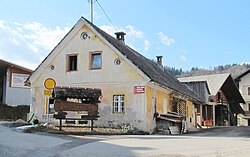
Osredek pri Dobrovi
Osredek pri Dobrovi | |
|---|---|
 | |
| Coordinates: 46°5′3.54″N 14°22′30.25″E / 46.0843167°N 14.3750694°E | |
| Country | |
| Traditional region | Upper Carniola |
| Statistical region | Central Slovenia |
| Municipality | Dobrova–Polhov Gradec |
| Area | |
| • Total | 1.61 km2 (0.62 sq mi) |
| Elevation | 506.6 m (1,662.1 ft) |
| Population (2020) | |
| • Total | 82 |
| • Density | 51/km2 (130/sq mi) |
| [1] | |
Osredek pri Dobrovi (pronounced [ɔˈsɾeːdɛk pɾi ˈdoːbɾɔʋi]) is a village in the hills northwest of Dobrova in the Municipality of Dobrova–Polhov Gradec in the Upper Carniola region of Slovenia.[2]
Name[edit]
The name of the settlement was changed from Osredek to Osredek pri Dobrovi in 1953.[3] The name Osredek pri Dobrovi literally means 'Osredek near Dobrova'. The name Osredek is shared with several other settlements in Slovenia and is derived from the Slovene word osredek 'center', variously referring to an island, a space between two hills, a grove in the middle of a hay field, or a rise in the middle of a flat area.[4] In the past it was known as Osredeck in German.[5]
References[edit]
- ^ Statistical Office of the Republic of Slovenia
- ^ Dobrova–Polhov Gradec municipal site
- ^ Spremembe naselij 1948–95. 1996. Database. Ljubljana: Geografski inštitut ZRC SAZU, DZS.
- ^ Snoj, Marko (2009). Etimološki slovar slovenskih zemljepisnih imen. Ljubljana: Modrijan. p. 295.
- ^ "Uebersicht der in Folge a. h. Entschließung vom 26. Juli 1849 genehmigten provisorischen Gerichtseintheilung des Kronlandes Krain". Intelligenzblatt zur Laibacher Zeitung. No. 141. November 24, 1849. p. 21.
External links[edit]
 Media related to Osredek pri Dobrovi at Wikimedia Commons
- Osredek pri Dobrovi on Geopedia


