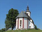
Planina nad Horjulom
Planina nad Horjulom | |
|---|---|
 | |
| Coordinates: 46°2′52.02″N 14°12′54.88″E / 46.0477833°N 14.2152444°E | |
| Country | |
| Traditional region | Upper Carniola |
| Statistical region | Central Slovenia |
| Municipality | Dobrova–Polhov Gradec |
| Area | |
| • Total | 4.44 km2 (1.71 sq mi) |
| Elevation | 772.6 m (2,534.8 ft) |
| Population (2020) | |
| • Total | 121 |
| • Density | 27/km2 (71/sq mi) |
| [1] | |
Planina nad Horjulom (pronounced [plaˈnìːna nat xɔˈɾjúːlɔm]) is a dispersed settlement northwest of Horjul in the Municipality of Dobrova–Polhov Gradec in the Upper Carniola region of Slovenia.[2] It includes the hamlets of Kolobocija, Lom, Pustota, and Zameja, as well as part of the hamlet of Suhi Dol.[3]
Name[edit]
The name of the settlement was changed from Planina to Planina nad Horjulom in 1953.[4] The name Planina nad Horjulom literally means 'Planina above Horjul'. The name Planina is shared with several other settlements in Slovenia and means 'alpine pasture'.[5]
Church[edit]

The local church is dedicated to Saint Andrew.[6] It was first mentioned in written sources in 1526 and the current structure was built around 1659. The area for the congregation is divided by piers into a wide central nave flanked by narrower areas on the north and south. The part on the north has been converted into a chapel. The chancel is arched with a richly crested stellar vault. The main altar, which dates to 1850, and both side altars are the work of Jurij Tavčar, a sculptor from Idrija. He also used older Baroque sculptures in creating them. The altar dedicated to Our Lady of Sorrows dates to 1717.[3]
Notable people[edit]
Notable people that were born or lived in Planina nad Horjulom include:
- Metod Trobec (1948–2006), serial killer[7]
Gallery[edit]
-
The hamlet of Zameja
-
The hamlet of Suhi Dol
-
Chapel shrine in Planina nad Horjulom
References[edit]
- ^ Statistical Office of the Republic of Slovenia
- ^ Dobrova–Polhov Gradec municipal site
- ^ a b Savnik, Roman (1971). Krajevni leksikon Slovenije, vol. 2. Ljubljana: Državna založba Slovenije. p. 423.
- ^ Spremembe naselij 1948–95. 1996. Database. Ljubljana: Geografski inštitut ZRC SAZU, DZS.
- ^ Snoj, Marko (2009). Etimološki slovar slovenskih zemljepisnih imen. Ljubljana: Modrijan. p. 309.
- ^ Družina RC Church in Slovenia journal site(in Slovene)
- ^ Koncilja, Franci. 2011. "Serijski morilec Metod Trobec" Časnik (30 May). (in Slovene)
External links[edit]
 Media related to Planina nad Horjulom at Wikimedia Commons
- Planina nad Horjulom on Geopedia


