
Portal:Myanmar
ကြိုဆိုပါတယ်။ / Welcome to the Myanmar Portal 

Myanmar, officially the Republic of the Union of Myanmar and also known as Burma (the official name until 1989), is a country in Southeast Asia. It is the largest country by area in Mainland Southeast Asia and has a population of about 55 million. It is bordered by Bangladesh and India to its northwest, China to its northeast, Laos and Thailand to its east and southeast, and the Andaman Sea and the Bay of Bengal to its south and southwest. The country's capital city is Naypyidaw, and its largest city is Yangon (formerly Rangoon).
Myanmar is a member of the East Asia Summit, Non-Aligned Movement, ASEAN, and BIMSTEC, but it is not a member of the Commonwealth of Nations despite once being part of the British Empire. Myanmar is a Dialogue Partner of the Shanghai Cooperation Organization. The country is very rich in natural resources, such as jade, gems, oil, natural gas, teak and other minerals, as well as also endowed with renewable energy, having the highest solar power potential compared to other countries of the Great Mekong Subregion. However, Myanmar has long suffered from instability, factional violence, corruption, poor infrastructure, as well as a long history of colonial exploitation with little regard to human development. In 2013, its GDP (nominal) stood at US$56.7 billion and its GDP (PPP) at US$221.5 billion. The income gap in Myanmar is among the widest in the world, as a large proportion of the economy is controlled by cronies of the military junta. Myanmar is one of the least developed countries; as of 2020, according to the Human Development Index, it ranks 147 out of 189 countries in terms of human development, the lowest in Southeast Asia. Since 2021, more than 600,000 people were displaced across Myanmar due to the surge in violence post-coup, with more than 3 million people in dire need of humanitarian assistance. (Full article...)
Selected articles -
-

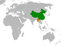
China–Myanmar relations (Chinese: 中缅关系; Burmese: တရုတ်မြန်မာဆက်ဆံရေး) are the international relations between the People's Republic of China and Myanmar. China and Myanmar have active bilateral relations with each other. The relation is often described as a pauk-phaw relationship (Burmese: ပေါက်ဖော်), based a Burmese term for kinsfolk that implicates special asymmetric obligations between the two countries.
Bilateral relations between China and Myanmar have faced difficulties due to the effects of alleged Chinese-sponsored debt-traps and alleged Chinese backing of rebels in Myanmar's territories. In recent years, the relations between China and Myanmar have faced some problems due to ongoing clashes between ethnic Chinese rebels and the Myanmar military near the China–Myanmar border. (Full article...) -

Wing of the dragonfly Burmalindenia in a cabochon of Burmese amber, showing typical red colouration of the amber. Scale bar = 5mm
Burmese amber, also known as Burmite or Kachin amber, is amber from the Hukawng Valley in northern Myanmar. The amber is dated to around 100 million years ago, during the latest Albian to earliest Cenomanian ages of the mid-Cretaceous period. The amber is of significant palaeontological interest due to the diversity of flora and fauna contained as inclusions, particularly arthropods including insects and arachnids but also birds, lizards, snakes, frogs and fragmentary dinosaur remains. The amber has been known and commercially exploited since the first century AD, and has been known to science since the mid-nineteenth century. Research on the deposit has attracted controversy due to its alleged role in funding internal conflict in Myanmar and hazardous working conditions in the mines where it is collected. (Full article...) -
Hkakaborazi National Park is a national park in northern Myanmar with an area of 1,472 sq mi (3,810 km2). It was established in 1998.
It surrounds Hkakabo Razi, the highest mountain in the country.
It ranges in elevation from 2,950 to 18,730 ft (900 to 5,710 m) comprising evergreen forest and mixed deciduous forests in Nogmung Township, Kachin State. It is managed by the Nature and Wildlife Conservation Division.
It is contiguous with Bumhpa Bum Wildlife Sanctuary and Hukaung Valley Wildlife Sanctuary. These protected areas together with Hponkanrazi Wildlife Sanctuary comprise the largest continuous expanse of natural forest called the Northern Forest Complex stretching over an area of 11,624 sq mi (30,110 km2). Its objective is to conserve the biodiversity of the Ayeyarwady and Chindwin river basins. (Full article...) -
On 2 July 2020, a major landslide at the Wai Khar jade mining site in the Hpakant area of Kachin State, Myanmar, killed between 175 and 200 miners in the country's deadliest-ever mining accident. At 06:30 local time (MMT) heavy rains triggered the collapse of a heap of mining waste, which came tumbling down into a lake. This generated a 6.1-meter (20 ft) wave of mud and water that buried those working at the Wai Khar mine. The miners killed or injured by the landslide were independent "jade pickers", who scavenge tailings from larger operators and who live in ramshackle quarters at the base of large mounds of rubble.
Myanmar's jade industry supplies 70% to 90% of the world jade supply. The industry had become known for its fatal accidents in the preceding years, with the previous deadliest accident in 2015 killing 116 people. While the government responded with promises to make reforms in the jade mining industry, activists claim that little has been done in practice since then. (Full article...) -
Buddhism (Burmese: ဗုဒ္ဓဘာသာ), specifically Theravāda Buddhism (Burmese: ထေရဝါဒဗုဒ္ဓဘာသာ), is the official and state religion of Myanmar since 1961, and practiced by nearly 90% of the population. It is the most religious Buddhist country in terms of the proportion of monks in the population and proportion of income spent on religion. Adherents are most likely found among the dominant Bamar people, Shan, Rakhine, Mon, Karen, and Chinese who are well integrated into Burmese society. Monks, collectively known as the sangha (community), are venerated members of Burmese society. Among many ethnic groups in Myanmar, including the Bamar and Shan, Theravada Buddhism is practiced in conjunction with the worship of nats, which are spirits who can intercede in worldly affairs.
Regarding the practice of Buddhism, two popular practices stand out: merit-making and vipassanā meditation. There is also the less popular weizza path. Merit-making is the most common path undertaken by Burmese Buddhists. This path involves the observance of the Five precepts and accumulation of good merit through charity (dana, often to monks) and good deeds to obtain a favorable rebirth. The meditation path, which has gained ground since the early 1900s, is a form of Buddhist meditation which is seen as leading to awakening and can involve intense meditation retreats. The weizza path is an esoteric system of occult practices (such as recitation of spells, samatha and alchemy) believed to lead to life as a weizza (Burmese: ဝိဇ္ဇာ Pali: vijjā), a semi-immortal and supernatural being who awaits the appearance of the future Buddha, Maitreya (Arimeitaya). (Full article...) -

The 1968 Burma cyclone was regarded as the worst to strike the country during the 20th century before it was surpassed by another unnamed cyclone in 2004 and further, Cyclone Nargis in 2008, respectively. The first tropical cyclone of the 1968 North Indian Ocean cyclone season, it started as a depression on May 7 on the northern Andaman Sea. With low wind shear and warm sea surface temperatures, the storm intensified in the waters near Burma before heading northwestwards. It then started to rapidly intensify, with an eye becoming apparent on satellite imagery on May 9. Also that day, it reached its peak intensity, with 3-minute maximum sustained winds of 220 km/h (140 mph) by the Indian Meteorological Department, which is equivalent to a super cyclonic storm; however, the agency treated the system as a severe cyclonic storm. Little to no changes happened on the cyclone as it turned northeastwards, making landfall near Akyab (now Sittwe) between 18:00 and 21:00 UTC on that day. Land interaction rapidly weakened the storm, dissipating on May 10 as an area of low-pressure in south Chin State.
The predecessor to the cyclone caused light to moderate downpour to the Andaman Islands; however, no deaths were reported. Winds reported from the cyclone inland Burma reached an estimate of 60–100 mph, altogether with heavy rainfall and large storm surges. The former flooded the crops, submerging them in floodwaters in the process while the latter washed out villages near the path of the storm. Schools and hospitals throughout Akyab were destroyed by high winds and large waves, while the port suffered major damages. The town was almost destroyed due to the storm. In addition, some ships in the said harbor, including the Greek freighter Geros Michalos were reportedly sunk in the Bay of Bengal. Houses were destroyed during the storm and many livestock died, mainly due to drowning. The death toll from the cyclone was finalized in May 1968 at 1,037 individuals, while 2,000 more were reportedly missing. The property damages were estimated at Ks.15 million ($3.248 million USD). (Full article...) -
The COVID-19 pandemic in Myanmar is part of the worldwide pandemic of coronavirus disease 2019 (COVID-19) caused by severe acute respiratory syndrome coronavirus 2 (SARS-CoV-2). The virus was confirmed to have reached Myanmar on 23 March 2020. On 31 March 2020, the Committee for Coronavirus Disease 19 (COVID-19), headed by First Vice President Myint Swe and made up of members from the various union ministries, was formed by President Win Myint to combat the spread of COVID-19 in the country.
Although the government rapidly implemented containment measures and public health responses, the country had experienced one of the most severe COVID-19 outbreaks in Southeast Asia by late 2020. The UN raised concerns about Myanmar's vulnerability to the pandemic due to its weak healthcare infrastructure following poor investment over six decades of military rule, as well as ongoing internal conflict. (Full article...) -

General elections were held in Myanmar on 7 November 2010, in accordance with the new constitution, which was approved in a referendum held in May 2008. The election date was announced by the State Peace and Development Council (SPDC) on 13 August.
The elections were the fifth step of the seven-step "roadmap to democracy" proposed by the SPDC in 2003, the sixth and seventh steps being the convening of elected representatives and the building of a modern, democratic nation, respectively. However, the National League for Democracy boycotted the elections. The result was a sweeping victory for the Union Solidarity and Development Party, which won nearly 80% of seats contested across the upper and lower houses. The United Nations expressed concern about the fairness of the elections, and western countries dismissed them as fraudulent. (Full article...) -

Burmese nat statues in the shrine
The nats (နတ်; MLCTS: nat; IPA: [naʔ]) are god-like spirits venerated in Myanmar and neighbouring countries in conjunction with Buddhism. They are divided between the 37 Great Nats who were designated that status by King Anawrahta when he formalized the official list of nats. Most of the 37 Great Nats were human beings who met violent deaths.
There are two types of nats in Burmese Belief: nat sein (နတ်စိမ်း) which are humans that were deified after their deaths and all the other nats which are spirits of nature (spirits of water, trees etc.). (Full article...) -
The Kingdom of Pagan (Burmese: ပုဂံခေတ်, pronounced [bəɡàɰ̃ kʰɪʔ], lit. 'Pagan Period'; also known as the Pagan dynasty and the Pagan Empire; also the Bagan dynasty or Bagan Empire) was the first Burmese kingdom to unify the regions that would later constitute modern-day Myanmar. Pagan's 250-year rule over the Irrawaddy valley and its periphery laid the foundation for the ascent of Burmese language and culture, the spread of Bamar ethnicity in Upper Myanmar, and the growth of Theravada Buddhism in Myanmar and in mainland Southeast Asia.
The kingdom grew out of a small 9th-century settlement at Pagan (present-day Bagan) by the Mranma/Burmans. Over the next two hundred years, the small principality gradually grew to absorb its surrounding regions until the 1050s and 1060s when King Anawrahta founded the Pagan Empire, presumably for the first time unifying under one polity the Irrawaddy valley and its periphery. By the late 12th century, Anawrahta's successors had extended their influence farther to the south into the upper Malay Peninsula, to the east at least to the Salween river, in the farther north to below the current China border, and to the west, in northern Arakan and the Chin Hills. In the 12th and 13th centuries, Pagan, alongside the Khmer Empire, was one of two main empires in mainland Southeast Asia. (Full article...)


Did you know (auto-generated) -

- ... that as part of the coronation of Mindon Min, the square yuzana around the capital was designated a sanctuary?
- ... that the Myanmar Coast Guard was initially proposed as a civilian law enforcement agency before being established as a branch of the military three years later?
- ... that Rolling Stone named Mission of Burma's "Academy Fight Song" as one of the 100 greatest debut singles of all time?
- ... that Rangoon kept its own time for more than two decades after Burma Standard Time first came into effect?
- ... that the Burmese Buddhist monk Sagyo Thu-Myat successfully lobbied for the recalibration of the Burmese calendar?
- ... that the Myanmar Photo Archive (example photograph shown) revealed "a side of modern Myanmar that, until very recently, remained hidden in dusty attics"?
- ... that Maw Htun Aung, a Shan Nationalities League for Democracy candidate in the 2020 Myanmar general election, is Kachin, not Shan?
- ... that Maung O, Prince of Salin, and his sister Nanmadaw Me Nu became de facto rulers of Burma when King Bagyidaw was suffering from depression?
Related portals and projects
General images -
-
 Salween river at Mae Sam Laep on the Thai-Myanmar border (from Geography of Myanmar)
 -
 Jade Mine in Hpakant (from Geography of Myanmar)
 -

-
 19th-century funeral cart and spire, which would form part of the procession from the home to the place of cremation (from Culture of Myanmar)
 -
 Grandfather Island, Dawei (from Geography of Myanmar)
 -
 Myinhkin thabin - equestrian sport (from Culture of Myanmar)
 -
 Temples at Mrauk U, was the capital of the Mrauk U Kingdom, which ruled over what is now Rakhine State. (from History of Myanmar)
 -
 Pagan Kingdom during Narapatisithu's reign. Burmese chronicles also claim Kengtung and Chiang Mai. Core areas shown in darker yellow. Peripheral areas in light yellow. Pagan incorporated key ports of Lower Burma into its core administration by the 13th century. (from History of Myanmar)
 -
 A wide range of Burmese lacquerware from Bagan (from Culture of Myanmar)
 -
 Mountains near Pindaya on the Shan Plateau (from Geography of Myanmar)
 -
 Aerial view of a burned Rohingya village in Rakhine state, Myanmar, September 2017 (from History of Myanmar)
 -
 Sculpture of Myanmar mythical lion (from Culture of Myanmar)
 -
 British soldiers remove their shoes at the entrance of Shwedagon Pagoda. To the left, a sign reads "Foot wearing is strictly prohibited" in Burmese, English, Tamil, and Urdu. (from Culture of Myanmar)
 -
 The paddle steamer Ramapoora (right) of the British India Steam Navigation Company on the Rangoon river having just arrived from Moulmein. 1895. Photographers: Watts and Skeen (from History of Myanmar)
 -
 Former US President Barack Obama poses barefoot on the grounds of Shwedagon Pagoda, one of Myanmar's major Buddhist pilgrimage sites. (from Culture of Myanmar)
 -

-
 Political Map of Burma (Myanmar) c. 1450 CE. (from History of Myanmar)
 -
 A wedding procession, with the groom and bride dressed in traditional Burmese wedding clothes, reminiscent of royal attire (from Culture of Myanmar)
 -
 British soldiers on patrol in the ruins of the Burmese town of Bahe during the advance on Mandalay, January 1945. (from History of Myanmar)
 -
 Protesters in Yangon carrying signs reading "Free Daw Aung San Suu Kyi" on 8 February 2021. (from History of Myanmar)
 -
 Two female musicians play the saung at a performance in Mandalay. (from Culture of Myanmar)
 -
 British soldiers dismantling cannons belonging to King Thibaw's forces, Third Anglo-Burmese War, Ava, 27 November 1885. Photographer: Hooper, Willoughby Wallace (1837–1912). (from History of Myanmar)
 -
 The shores of Irrawaddy River at Nyaung-U, Bagan (from Geography of Myanmar)
 -
 A large fracture on the Mingun Pahtodawgyi caused by the 1839 Ava earthquake. (from Geography of Myanmar)
 -
 Myanmar (Burma) map of Köppen climate classification (from Geography of Myanmar)
 -
 Hlei pyaingbwè - a Burmese regatta (from Culture of Myanmar)
 -
 A bull fight, 19th-century watercolour (from Culture of Myanmar)
 -

-
 Aung San Suu Kyi addresses crowds at the NLD headquarters shortly after her release. (from History of Myanmar)
 -
 A group of Buddhist worshipers at Shwedagon Pagoda, an important religious site for Burmese Buddhists (from Culture of Myanmar)
 -
 Saint Mary's Cathedral in Downtown Yangon is the largest Roman Catholic cathedral in Burma. (from Culture of Myanmar)
 -
 Boxing match, 19th-century watercolour (from Culture of Myanmar)
 -
 Recorder's Court on Sule Pagoda Road, with the Sule Pagoda at the far end, Rangoon, 1868. Photographer: J. Jackson. (from History of Myanmar)
 -
 The restored Taungoo or Nyaungyan dynasty c. 1650 CE. (from History of Myanmar)
 -
 Vegetable stall on the roadside at the Madras Lancer Lines, Mandalay, January 1886. Photographer: Hooper, Willoughby Wallace (1837–1912). (from History of Myanmar)
 -
 A theatrical performance of the Mon dance (from Culture of Myanmar)
 -
 Protesters in Yangon with a banner that reads non-violence: national movement in Burmese, in the background is Shwedagon Pagoda. (from History of Myanmar)
 -
 Portuguese ruler and soldiers mounting an Elephant. Philips, Jan Caspar (draughtsman and engraver) (from History of Myanmar)
 -

-
 Mount Popa, a dormant volcano in the Central Lowlands (from Geography of Myanmar)


_headquarter.jpg)


Major topics
Categories

More topics

Associated Wikimedia
The following Wikimedia Foundation sister projects provide more on this subject:
-
 Commons
Free media repository -
 Wikibooks
Free textbooks and manuals -
 Wikidata
Free knowledge base -
 Wikinews
Free-content news -
 Wikiquote
Collection of quotations -
 Wikisource
Free-content library -
 Wikiversity
Free learning tools -
 Wikivoyage
Free travel guide -
 Wiktionary
Dictionary and thesaurus


