
Puerto Rico Highway 862
Highway 862 | ||||
|---|---|---|---|---|
| Ruta 862 | ||||
| Route information | ||||
| Maintained by Puerto Rico DTPW | ||||
| Length | 3.6 km[1] (2.2 mi) | |||
| Major junctions | ||||
| South end | ||||
| North end | ||||
| Location | ||||
| Country | United States | |||
| Territory | Puerto Rico | |||
| Municipalities | Bayamón, Toa Alta, Toa Baja | |||
| Highway system | ||||
| ||||

Puerto Rico Highway 862 (PR-862) is a north–south road located between the municipalities of Bayamón and Toa Alta in Puerto Rico. With a length of 3.6 kilometers (2.2 mi), it begins at its intersection with PR-861 in Pájaros barrio and ends at its junction with PR-864 in Hato Tejas area.[2]
Route description[edit]
This highway has a single lane per direction in the entire length and provides access to several communities and neighborhood developments between Pájaros, Mucarabones, Candelaria and Hato Tejas barrios.[3] In Bayamón, PR-862 has two segments separated by the one located within Toa Alta. The southern section in Bayamón is located in Pájaros barrio, extending from its southern terminus at PR-861 junction to the Toa Alta municipal limit. In Toa Alta, it has a short length though Mucarabones barrio, extending from the Bayamón municipal limit to its intersection with PR-863 on the Toa Alta–Toa Baja–Bayamón municipal tripoint. Then, PR-862 continues to the north through Hato Tejas barrio as the northern section in Bayamón until its end at PR-864.[4]
- Puerto Rico Highway 862
-
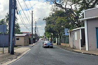 Northern terminus at PR-864 junction in Hato Tejas, Bayamón, looking south
 -
 Southbound sign in Hato Tejas, Bayamón
.jpg)
.jpg)
History[edit]
Prior to its numerical designation, PR-862 was only known as Camino Pájaros.[5] The current numerical designation corresponds to the 1953 Puerto Rico highway renumbering, a process implemented by the Puerto Rico Department of Transportation and Public Works (Spanish: Departamento de Transportación y Obras Públicas) that increased the insular highway network to connect existing routes with different locations around Puerto Rico.
Major intersections[edit]
| Municipality | Location | km[1] | mi | Destinations | Notes | |||
|---|---|---|---|---|---|---|---|---|
| Bayamón | Pájaros | 0.0 | 0.0 | Southern terminus of PR-862 | ||||
| Toa Alta |
No major junctions | |||||||
| Bayamón–Toa Baja– Toa Alta municipal tripoint | Pájaros–Hato Tejas– Candelaria–Mucarabones quadripoint | 1.3 | 0.81 | |||||
| Bayamón | Hato Tejas | 3.6 | 2.2 | Northern terminus of PR-862 | ||||
| 1.000 mi = 1.609 km; 1.000 km = 0.621 mi | ||||||||
See also[edit]
References[edit]
- ^ a b Google (29 February 2020). "PR-862" (Map). Google Maps. Google. Retrieved 29 February 2020.
- ^ National Geographic Maps (2011). Puerto Rico (Map). 1:125,000. Adventure Map (Book 3107). Evergreen, Colorado: National Geographic Maps. ISBN 978-1566955188. OCLC 756511572.
- ^ "Tránsito Promedio Diario (AADT)". Transit Data (Datos de Transito) (in Spanish). DTOP PR. p. 133. Archived from the original on 1 April 2019.
- ^ "Carretera 862, Bayamón, Puerto Rico". pr.geoview.info. Retrieved 7 February 2020.
- ^ "Bayamón, Memoria Núm. 24" (PDF). Puerto Rico Planning Board (in Spanish). 1952. Retrieved 22 August 2023.
External links[edit]
 Media related to Puerto Rico Highway 862 at Wikimedia Commons
This Puerto Rico road-related article is a stub. You can help Wikipedia by expanding it. |