Shal District
Shal District
Persian: بخش شال | |
|---|---|
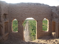
 Ruins near Kheyrabad, Shal | |
| Coordinates: 35°55′34″N 49°48′37″E / 35.92611°N 49.81028°E[1] | |
| Country | Iran |
| Province | Qazvin |
| County | Buin Zahra |
| Capital | Shal |
| Population (2016)[2] | |
| • Total | 23,238 |
| Time zone | UTC+3:30 (IRST) |
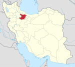
Shal District (Persian: بخش شال) is in Buin Zahra County, Qazvin province, Iran. Its capital is the city of Shal.
At the 2006 National Census, its population was 23,935 in 5,527 households.[3] The following census in 2011 counted 23,572 people in 6,373 households.[4] At the latest census in 2016, the district had 23,238 inhabitants in 6,609 households.[2]
| Administrative Divisions | 2006[3] | 2011[4] | 2016[2] |
|---|---|---|---|
| Qaleh Hashem RD | 4,873 | 4,218 | 3,765 |
| Zeynabad RD | 3,958 | 4,358 | 4,183 |
| Shal (city) | 15,104 | 14,996 | 15,290 |
| Total | 23,935 | 23,572 | 23,238 |
| RD: Rural District | |||
References[edit]
- ^ OpenStreetMap contributors (8 March 2024). "Shal District (Buin Zahra County)" (Map). OpenStreetMap. Retrieved 8 March 2024.
- ^ a b c "Census of the Islamic Republic of Iran, 1395 (2016)". AMAR (in Persian). The Statistical Center of Iran. p. 26. Archived from the original (Excel) on 30 November 2021. Retrieved 19 December 2022.
- ^ a b "Census of the Islamic Republic of Iran, 1385 (2006)". AMAR (in Persian). The Statistical Center of Iran. p. 26. Archived from the original (Excel) on 20 September 2011. Retrieved 25 September 2022.
- ^ a b "Census of the Islamic Republic of Iran, 1390 (2011)". Syracuse University (in Persian). The Statistical Center of Iran. p. 26. Archived from the original (Excel) on 19 January 2023. Retrieved 19 December 2022.


