
Wikipedia:Graphics Lab/Map workshop/Archive/Jan 2013
Stale[edit]
The Chhattisgarh state and district maps are outdated, need update[edit]
-
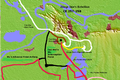
 Chhattisgarh State (India) with district boundaries and city marks
 -
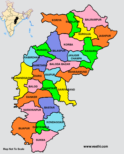
 Districts (colored) of Chhattisgarh State (India)


Article(s): Chhattisgarh, Surguja
Request: These maps are outdated. After creation of 9 new districts, there are now 27 districts in Chhattisgarh[1], these maps shown only 19 of them. The boundary of old districts are outdated as they have now been divided into new districts.
This map of Chhattisgarh has all new districts and it seems to be updated and correct - http://www.veethi.com/images/places/states/chhattisgarh_state_map_with_districts.png Siddu (talk) 07:21, 22 November 2012 (UTC)
Graphist opinion(s):
3 Rebellions in Shouchun[edit]
-
 Map of the 2nd conflict
 -
 Map of the 3rd conflict
 -
 Map of the 1st conflict


Article(s): Guanqiu Jian and Wen Qin's Rebellion, Zhuge Dan's Rebellion, Wang Ling's Rebellion
Request: Can someone improve and master them? Make them good. And appealing to the eye. Eric - Contact me please. I prefer conversations started on my talk page if the subject is changed 00:45, 23 November 2012 (UTC)
Graphist opinion(s):
Taylorsville Basin[edit]
Article(s): Taylorsville Basin
Request: Taylorsville Basin needs a simple map of the US east coast with the outline of the basin. The outline should look like the picture on page 15 of this publication (http://www.ldeo.columbia.edu/~letour/reprints/letour2003.pdf). I think a relief map would be ideal. Thank you for your time! --Tobias1984 (talk) 16:07, 1 December 2012 (UTC)
Graphist opinion(s):
Resolved[edit]
Help the colorblind[edit]
-
 Provinces of the Roman Empire
 -
 recoloured
 -
 recoloured 2


Article(s): More than 100 pages, plus lots on other wikis
Request: I can't tell the color difference between imperial and senatorial provinces. Could you please change one of the two colors so that anyone can distinguish them and won't confuse them with the client states? Nyttend (talk) 19:41, 5 December 2012 (UTC)
- Graphist opinion: Since I am not colour blind, I used this simulator: Vischeck. I can certainly see how the existing colours do "run together" with red/green colour-blindness.
- I've uploaded the version above as a "test" for you - according to that website's check this is much easier to distinguish (even though it is now...pink/green), but you will need to be the final judge.
- It's easy enough to change the colours en-masse with a find/replace in the svg in a text editor, so if you'd like something altered, just say so.
- Note: If someone wants to tell me why this thumbnail won't render on the image page, but works with generated views or inserted onto pages, like here, that would be good - I search/replaced some HTML colour values from the original, in Notepad++, no other changes... What I can establish is that the image page "wants" an 800px thumbnail, so it goes to [1] which gives "Error creating thumbnail: Unable to save thumbnail to destination" But a 799 pixel or 801 pixel thumbnail, or any other size work fine - for some reason 800px is snafu... Begoon talk 13:46, 9 December 2012 (UTC)
- I can easily tell the difference between the three colors in the {{Information}} section, but that's not enough to tell. Perhaps I'm like most red-green people, or perhaps I'm weird, but I can tell colors a lot better when they're next to each other than when they're apart; for example, on the old map I can see that there's a little difference between Asia and Galatia, but I can't tell you which one is the same color as Britannia. For that reason, although I'm guessing that the new map will be fine, I can't say that 100% confidently until the thumbnail issue is resolved and I can see the full-size map. Nyttend (talk) 14:18, 9 December 2012 (UTC)
- Never mind; while 800px isn't working, other resolutions work fine, so I've checked http://upload.wikimedia.org/wikipedia/commons/thumb/2/28/RomanEmpire_117_recoloured.svg/799px-RomanEmpire_117_recoloured.svg.png. I can easily see the difference between imperial and senatorial, so thank you, but I'm also having a little difficulty with the client states: is Regnum Bospori the only client state, or are there others? It might help if you changed its color too. Nyttend (talk) 14:20, 9 December 2012 (UTC)
- I think it's the only one (Regnum Bospori) - I had the same dilemma, but search/replace only finds one for the colour and one for the key (#cccccc). Try the new one - I changed the grey a bit for client states and it looks ok in the Vischeck thing - the new filename clears up the thumbnail not working too. When you're happy, we can upload it over the original - didn't want to do that until you were happy it was better. Begoon talk 15:10, 9 December 2012 (UTC)
- Yes, much much simpler; I'd say go ahead and upload on top of the original. Thanks a lot! Nyttend (talk) 15:17, 9 December 2012 (UTC)
- Ok - I think I did that, but the cache is all over the place with that one, hopefully it's correct... Things like this work ok: [2] - but not showing up correctly as yet for all sizes or on file page - what's really bizarre is that this request for an 800px thumbnail works: [3] but the file page, which "wants" exactly that size, doesn't show the new version for me at the moment, however often I purge/refresh..., hopefully it will settle down... Begoon talk 15:33, 9 December 2012 (UTC)
- See the "Having problems with a corrupted image" section of Commons:COM:AN, where I've asked for administrative help. Thanks for the work! Nyttend (talk) 19:51, 9 December 2012 (UTC)
- Ok - I think I did that, but the cache is all over the place with that one, hopefully it's correct... Things like this work ok: [2] - but not showing up correctly as yet for all sizes or on file page - what's really bizarre is that this request for an 800px thumbnail works: [3] but the file page, which "wants" exactly that size, doesn't show the new version for me at the moment, however often I purge/refresh..., hopefully it will settle down... Begoon talk 15:33, 9 December 2012 (UTC)
- Yes, much much simpler; I'd say go ahead and upload on top of the original. Thanks a lot! Nyttend (talk) 15:17, 9 December 2012 (UTC)
- I think it's the only one (Regnum Bospori) - I had the same dilemma, but search/replace only finds one for the colour and one for the key (#cccccc). Try the new one - I changed the grey a bit for client states and it looks ok in the Vischeck thing - the new filename clears up the thumbnail not working too. When you're happy, we can upload it over the original - didn't want to do that until you were happy it was better. Begoon talk 15:10, 9 December 2012 (UTC)
Scapa Flow map[edit]
File:Internment at Scapa Flow.svg has a couple of typographical errors in it (see here for a discussion of it) that need to be corrected. "Swita" and "Swita Sound" need to be corrected to Switha and "Glimps Holm" needs to be Glims Holm. The creator of the map retired about a year ago, and I don't know heads from tails on imagery work. Could someone make the necessary corrections please? Thanks. Parsecboy (talk) 15:25, 24 December 2012 (UTC)
- I'll take a shot at this. Its really simple I think. ChrisGualtieri (talk) 16:46, 24 December 2012 (UTC)
Lena River: remove border[edit]
-
 Two maps showing the relation of the sources of Lena river to lake Baikal

Article(s): Lena River
Request: Remove the border around the image. Shrigley (talk) 08:54, 25 December 2012 (UTC)
Graphist opinion:
- Done, cropped out border, made the split between maps a strong black for clarity. ChrisGualtieri (talk) 15:22, 1 January 2013 (UTC)
Better colors for US/China comparative map[edit]
The file is: China USA Locator.png

— Preceding unsigned comment added by Lucquessoy (talk • contribs) 12:35, 30 December 2012 (UTC)
Please could we change the colors. Currently they are not very appropriate, neither matching the flags or any symbolism. China should be red like its flag, and the US probably sky blue.
Thank you. — Preceding unsigned comment added by Lucquessoy (talk • contribs) 12:32, 30 December 2012 (UTC)
- Uploaded it, clear cache and it should be fine unless that bug hasn't been resolved yet. ChrisGualtieri (talk) 03:32, 1 January 2013 (UTC)
Can some please tell me how to "How to highlight Map". Thank You. — Preceding unsigned comment added by Ryan101game (talk • contribs) 03:03, 3 January 2013 (UTC)
Better European Parliament constituency map[edit]
-
 Map of European Parliament Constituencies
 -

-

-


Article(s): European Parliament constituency
Request: Please can someone make a more accurate version of this (especially with the Danish islands) and make each constituency an object. Right now the whole of Ireland is one object, ditto with Poland. Also, make the islands (particularly those in Denmark, Greece, Italy, France, Sweden and Spain) part of the same object as the constituency they belong to. Keep Malta and Cyprus as individual objects. Finally add the constituency Overseas_Territories_of_France_(European_Parliament_constituency) and make them a single object, get rid of the blank space at the edge and move the Overseas Territories of France constituency and the Cyprus constituency to boxes outside of the rest of the map like Hawaii and Alaska are in the other map. Thanks if someone has the time to do this, it'll be very useful! Jay942942 (talk) 14:33, 18 November 2012 (UTC)
Graphist opinion(s):
![]() Request taken by ArnoldPlaton (talk).. But it might take a while, as first I'll have to vectorize this map. - ArnoldPlaton (talk) 12:44, 2 December 2012 (UTC)
Request taken by ArnoldPlaton (talk).. But it might take a while, as first I'll have to vectorize this map. - ArnoldPlaton (talk) 12:44, 2 December 2012 (UTC)
 Done Is it ok? I changed the projection, because the old one was way too squished. - ArnoldPlaton (talk) 16:22, 15 January 2013 (UTC)
Request: topographic map of France[edit]
I have looked everywhere for a topographic map of France (that is: a svg-file). On it should be displayed the natural features of France: lakes, mountains, sea etc. etc. and not the cities. Wereldburger758 (talk) 12:37, 9 January 2013 (UTC)
- Found such a map on ShareMap.org. This is the result:

- File:France map Lambert-93 topographic-blank.svg is already sitting over in commons. Kmusser (talk) 20:33, 15 January 2013 (UTC)
UN members[edit]
-
 Current map

![[1]](https://upload.wikimedia.org/wikipedia/commons/thumb/2/28/RomanEmpire_117_recoloured.svg/800px-RomanEmpire_117_recoloured.svg.png)
![[2]](https://upload.wikimedia.org/wikipedia/commons/thumb/e/e7/RomanEmpire_117.svg/755px-RomanEmpire_117.svg.png)
![[3]](https://commons.wikimedia.org/w/thumb.php?f=RomanEmpire%20117.svg&w=800)
Article(s): Member states of the United Nations
Request: Please change Palestine's color to that of the Holy See. Lihaas (talk) 22:09, 29 November 2012 (UTC)
Graphist opinion(s): If you take a good look, you will see that that already has been done. Wereldburger758 (talk) 12:45, 16 January 2013 (UTC)