
Wikipedia:Graphics Lab/Map workshop/Archive/Jan 2023
| This page is an archive. Do not edit the contents of this page. Please direct any additional comments to the current main page. |
 | Archives of 2023: January, February, March, April, May, June, July, August, September, October, November, December |
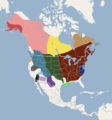
E-Verify US Map
- Article(s)
- E-Verify
- Illegal immigration to the United States
- Request
- Hi i am just wondering can sombody make a USA Map, of US states On E-Verify.
As of January 1, 2023 the following states require E-Verify for some or all employers:
- Alabama,
- Arizona,
- Colorado,
- Florida,
- Georgia,
- Idaho,
- Indiana,
- Louisiana,
- Michigan,
- Minnesota,
- Mississippi,
- Missouri,
- Nebraska,
- North Carolina,
- Oklahoma,
- Pennsylvania,
- South Carolina,
- Tennessee,
- Texas,
- Utah,
- Virginia
- West Virginia.
Here are the sources.[1] Thanks.La lopi (talk) 02:01, 2 February 2023 (UTC)
- Discussion
Hi, I can take this but the source you gave is not clear at all about the states that require E-Verify on 1 January 2023. The information is until 2021 and I have not found any reference to the states in question.
![]() Request taken by Ikonact (talk) 15:44, 8 February 2023 (UTC).
Hi, i hope this helps i found this on the website of the National Conference of State Legislatures, it has its own map and information on the states (It should be noted it says these numbers are from 2015, So the Map could be called as E verify states as of 20150. hope this helps you. Thanks.[1] La lopi (talk) 01:48, 9 February 2023 (UTC)
Request taken by Ikonact (talk) 15:44, 8 February 2023 (UTC).
Hi, i hope this helps i found this on the website of the National Conference of State Legislatures, it has its own map and information on the states (It should be noted it says these numbers are from 2015, So the Map could be called as E verify states as of 20150. hope this helps you. Thanks.[1] La lopi (talk) 01:48, 9 February 2023 (UTC)
- @La lopi:Draft here. Could you please check and let me know. If you find a more recent source I will be glad to update. Thanks --Ikonact (talk) 22:30, 11 February 2023 (UTC)
- @Ikonact: Hi the map looks good, i had a check of the source and it looks good, i will keep a look out for updates for this map. but is it right with you, for the meantime i can put this map on the pages, that i planed to. thanks again, have a great weekend.La lopi (talk) 10:51, 12 February 2023 (UTC)
- @La lopi: I found this source from December 2022. I am not knowledgeable on the subject and I prefer to limit my intervention to generating maps with a source that is given by more experienced people. If you find this source reliable I can update the map based on it. I can put the five categories that are identified, namely:
- States that require all or most employers to use E-Verify: Alabama, Arizona, Georgia, Mississippi, North Carolina, South Carolina, Tennessee, and Utah.
- Public employers and/or contractors with the state: Florida, Indiana, Missouri, Nebraska, Oklahoma, Pennsylvania, and Texas.
- Public employers only: Idaho and Virginia.
- States with local/municipality E-Verify requirements: Colorado (Denver), Florida (Hernando County, Bonita Springs), Michigan (Ingham County, Macomb County, Oakland County), Missouri (O’Fallon), Nebraska (Fremont), and Washington (Hoquiam, Pierce County, Woodland).
- State contractors only: Colorado, Louisiana, and Minnesota.
- The categories are different. You can suggest grouping them. May be the fourth category can be omitted as it goes on lower level and some states are in other categories. Up to you! Thanks––Ikonact (talk) 15:52, 12 February 2023 (UTC)
- @La lopi: I found this source from December 2022. I am not knowledgeable on the subject and I prefer to limit my intervention to generating maps with a source that is given by more experienced people. If you find this source reliable I can update the map based on it. I can put the five categories that are identified, namely:
- @Ikonact: I checked that source, and i don't know about that group/website or feel comfortable using that source. I feel much more comfortable with the first map, and first source you done.La lopi (talk) 22:28, 12 February 2023 (UTC)
{{resolved}}
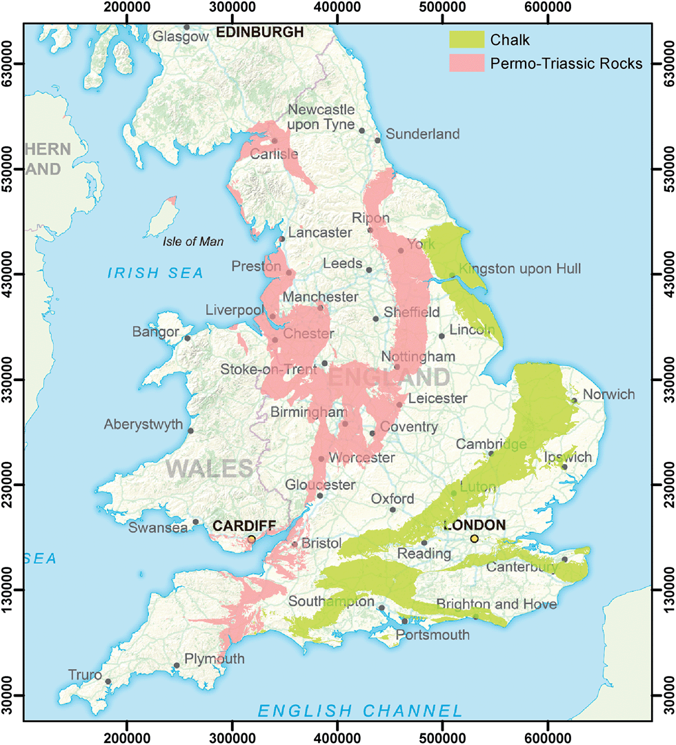
Topographical map of southern England
- Article(s)
- Downland, and may also be useful on multiple articles we have on specific downs.
- Request
- I want to create a map of the downland in the UK. For this I need a topographical map of southern England. I can add the annotation of hill range names myself. The map needs to go at least as far north as Cambridge and at least as far West as Exeter. To the south and the east it needs to go all the way to the sea. Thanks, SpinningSpark 15:39, 30 December 2022 (UTC)
- Discussion
Note that File:Blank topographic map of the British Isles.svg already exists. SpinningSpark 15:39, 30 December 2022 (UTC)
Extended content
|
|---|
.png)
@Spinningspark: I do understand you have lost a map which you valued, I'm sorry for that.
|
Uploaded Downland in southern England
![]() Done
{{resolved}}
Done
{{resolved}}
Request
-
 Sub-Saharan Africa without the Sahel region
 -
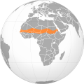 The Sahel region


- Article(s)
- Sub-Saharan Africa
- Request
- Add the Sahel region to sub-Saharan Africa in the map of sub-Saharan Africa because the Sahel region is a part of sub-Saharan Africa. The definition of sub-Saharan Africa is the area and regions of the continent of Africa that lie south of the Sahara, and the Sahel region is a region of the continent of Africa that lies south of the Sahara. -- Treetoes023 (talk) 01:46, 28 February 2023 (UTC)
- Discussion
@Treetoes023: No, it's not that simple. 1) There is no clear definition for any of them, let alone "sub-Sahara". 2) The source that use the definition that you mentioned tend to include the Sahel in the Sahara (this is the case for Britannica, the source that you wanted use when you made the first request). 3) If you want to show the countries that are often considered as part of Sub-Saharan Africa, then that's another subject. M.Bitton (talk) 12:53, 28 February 2023 (UTC)
- @M.Bitton: Yes, it's that simple.
- The Sahel has a clear definition, it is the region directly south of the Sahara that seperates the Sahara from the Sudanian savanna making it by defintion sub-Saharan.
- Britannica actually does acknowledge that the Sahel is not a part of the Sahara in both the Sahara's and Sahel's respective articles, along with many other sources such as these 123 (page 23) and more that I can provide if you want me to.
- The source I gave you when I first made my request was a mistake, I pulled the first image of google that clearly showed boundaries of the Sahara without really inspecting it which is entirely my fault. The source I gave you depicts the Sahara-Sahel which is lumps the Sahara and Sahel together due to political similarities and not geography which is what my request aims to depict.
- I'm sorry if my response comes off as rude, it is not my intention but I can see that it definitely sounds like someone who doesn't like you wrote it which is not the case I just don't have the time to change the wording to make it sound less aggressive because I have to study for SATs lol. Treetoes023 (talk) 20:23, 28 February 2023 (UTC)
- @Treetoes023: I disagree with your WP:OR based conclusion. My offer of creating a map that shows the countries that are usually considered by RS as part of Sub-Saharan Africa still stands (shown in the PDF that you cited). M.Bitton (talk) 20:29, 28 February 2023 (UTC)
- @M.Bitton: I do no think my conclusion is WP:OR. Some of the sources I provided directly support my claim, for example "The Sahel region of sub-Saharan Africa..." (page 23). That would make it not original research. Treetoes023 (talk) 03:08, 1 March 2023 (UTC)
- @Treetoes023: the map that you're proposing is pure WP:OR. The only sources that matter when it comes to creating maps are RS maps and not our interpretation of a text (unless it's unambiguous, such as lists of countries, etc). While the Sahara and the Sahel are physical regions, sub Saharan Africa is a political region that is rarely portrayed as a physical one (it took me ages to find a source for the physical region that you originally requested). In hindsight, and given the intended purpose of the map, that was a bad idea. I have now adjusted the maps so that they comply with RS and the common definitions. Sudan was added in light green (in line with the other map that is on the article). M.Bitton (talk) 18:46, 1 March 2023 (UTC)
- @M.Bitton: I agree with your decision, I am sorry for my stubbornness. Although, I still think a geographic map of sub-Saharan Africa is not without merit, not as the main picture on the article of course. Could you leave all of the maps as they originally were including that the Sahel was not included in sub-Saharan Africa and make separate maps based on the political definitions and we use the political based maps in the article. I think that the geography maps could be useful in the future even if they aren't useful right now. Treetoes023 (talk) 20:02, 1 March 2023 (UTC)
- @Treetoes023: I don't see the point of letting a confusing map that isn't used hog the common name. If you ever need similar ones, ping me and I'll happily upload them. M.Bitton (talk) 21:12, 1 March 2023 (UTC)
- @M.Bitton: Will do. Treetoes023 (talk) 22:54, 1 March 2023 (UTC)
- @Treetoes023: I don't see the point of letting a confusing map that isn't used hog the common name. If you ever need similar ones, ping me and I'll happily upload them. M.Bitton (talk) 21:12, 1 March 2023 (UTC)
- @M.Bitton: I agree with your decision, I am sorry for my stubbornness. Although, I still think a geographic map of sub-Saharan Africa is not without merit, not as the main picture on the article of course. Could you leave all of the maps as they originally were including that the Sahel was not included in sub-Saharan Africa and make separate maps based on the political definitions and we use the political based maps in the article. I think that the geography maps could be useful in the future even if they aren't useful right now. Treetoes023 (talk) 20:02, 1 March 2023 (UTC)
- @Treetoes023: the map that you're proposing is pure WP:OR. The only sources that matter when it comes to creating maps are RS maps and not our interpretation of a text (unless it's unambiguous, such as lists of countries, etc). While the Sahara and the Sahel are physical regions, sub Saharan Africa is a political region that is rarely portrayed as a physical one (it took me ages to find a source for the physical region that you originally requested). In hindsight, and given the intended purpose of the map, that was a bad idea. I have now adjusted the maps so that they comply with RS and the common definitions. Sudan was added in light green (in line with the other map that is on the article). M.Bitton (talk) 18:46, 1 March 2023 (UTC)
- @M.Bitton: I do no think my conclusion is WP:OR. Some of the sources I provided directly support my claim, for example "The Sahel region of sub-Saharan Africa..." (page 23). That would make it not original research. Treetoes023 (talk) 03:08, 1 March 2023 (UTC)
- @Treetoes023: I disagree with your WP:OR based conclusion. My offer of creating a map that shows the countries that are usually considered by RS as part of Sub-Saharan Africa still stands (shown in the PDF that you cited). M.Bitton (talk) 20:29, 28 February 2023 (UTC)
{{resolved}}
Simple map with two location pins
-
 The location of Harrowdown Hill in comparison with Southmoor, both in Oxfordshire, England

- Article(s)
- David Kelly (weapons expert)
- Request
- Could someone do a better map than this, with larger location pins? I did the original, which isn't great (it's way too small in the article), and I am sure a better version could be provided. Cheers – SchroCat (talk) 11:11, 28 December 2022 (UTC)
- Add: the blue pin is at (approx) 51.701467, -1.438691; the red one is at 51.679818, -1.427914. The positions can be sourced to "Picture Gallery". The Times. 19 July 2003. p. 1. Thanks - SchroCat (talk) 21:04, 9 January 2023 (UTC)
- Discussion
Map of Kalbiyya tribal territory
-
 Map 1 of Latakia Governorate
 -
 Map 2 of Tartous Governorate (directly south of Map 1)
 -
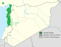 Map 3 Alawite distribution
 -
 Distribution of the Kalbiyya tribe in northwestern Syria


- Article(s)
- Kalbiyya
- Request
- The Kalbiyya are one of four tribes in Syria belonging to the Alawite religion. The Alawites all live in a small area - Latakia Governorate and Tartous Governorate- in north west Syria. Their main claim to fame is that it's the tribe of Hafez Al-Assad and Bashar Al-Assad. Their tribal territory (along with the other 3 tribes) is shown on this map of the Latakia and Tartous Governorates (from Goldsmith, Leon T. (2015). Cycle of Fear: Syria's Alawites in War and Peace.). The same map but with clearer colours is shown on page xii of the earlier PhD thesis of the same author. Would it be possible to map the Kalbiyya tribal territory on to a single map which combines 1 and 2 above? Alternatively, and maybe this is the most feasible/best option, use map 3 and shrink down the green area to just the Kalbiyya area. Or just use Map 1 as most of the territory is in Latakia Governorate. DeCausa (talk) 14:04, 15 January 2023 (UTC)
- Discussion
![]() Request taken by M.Bitton (talk) 15:42, 21 January 2023 (UTC).
Request taken by M.Bitton (talk) 15:42, 21 January 2023 (UTC).
- @DeCausa: The map is ready. Could you please provide suggestions for the title, description, categories, structured data, etc.? Thanks. M.Bitton (talk) 18:27, 22 January 2023 (UTC)
- @M.Bitton:, That's great, thanks! Tbh, I thought it it was a long-shot that someone would take it on. I'm not too familiar with this. I assume by title, description and category that's the descriptors I see on Commons files. The title might be "File:Kalbiyya tribal area"; description= Map of northwestern Syria showing the settlement area of the Kalbiyya Alawite tribe; 2 categories: Alawites, Maps of Syria; I don't really understand what's needed for "structured data". Could you explain? DeCausa (talk) 21:49, 22 January 2023 (UTC)
- How do I actually see it? DeCausa (talk) 22:08, 22 January 2023 (UTC)
 Done @DeCausa: please have a look at the map and let me know if I missed something. Don't worry about the structured data for now, anything else other than Q6351774 can always be added later on. M.Bitton (talk) 22:28, 22 January 2023 (UTC)
- @M.Bitton: That's excellent accuracy. Thank you. I'm just wondering if it would be possible to do a blow up of the Alawite area in the style of this map. In an article the relevant red area will be quite small for readers to see otherwise. If a problem, no worries. The map as it is is great. DeCausa (talk) 22:48, 22 January 2023 (UTC)
{{Resolved}}
Trying again: Request - Update Luxembourg tram network maps
-
 Luxembourg tram network German map
 -
 Luxembourg tram network French map
 -
 Luxembourg tram network Luxembourgish map


- Article(s)
- Trams in Luxembourg
- Request
- The tram network was extended to Lycée Bonnevoie on 11 September and so the maps need updating.[2] The stop currently named as "Hippodrome" on the map needs to renamed "Leschte Steiwer/Dernier Sol" and the "Lycée Bonnevoie" stop needs to be renamed "Lycée Bouneweg", as per their officially revealed new names.[3] The under construction stops of "Aeroport de Luxembourg-Findel", "Ban de Gasperich", "Howald" and "Cloche d'Or" in the current iteration of the map, have also been respectively renamed "Findel Aéroport", "Wassertuerm", "Howald Gare" and "Stadion".[3] It would also be great to have a version of the map with an English-language legend in the bottom right for the Enlgish-language wikipedia. This should be built from the French map, as French-place names in Luxembourg are more common used by English-speakers (the "centre de remisage" label, will obviously just become "Tram depot"). Thanks. Luxofluxo (talk) 16:41, 1 November 2022 (UTC)
References
- Discussion
@Luxofluxo: judging by the messy code (not sure why they embedded raster images in it), this looks like something you could do all by yourself (using a decent text editor). Open the file and search and replace the relevant text (you'll notice that it's repeated twice, to create the effect, so don't be tempted to remove any of it). If for some of it doesn't align properly, let me know and I'll have a look at it. M.Bitton (talk) 18:30, 19 January 2023 (UTC)
- @M.Bitton Thanks. I'm not familar with creating maps, so not sure why the authors chose to do it in such a complicated way. With your help (thanks again), I've created an English language version of the map, using that methodology. A couple of issues remain. The airport station names don't align, and the box around the "Stadion" tram stop extends too far to the left. The tramline has also been extended between Gare Centrale and Lycée Bouneweg. I have no idea how to fill in the connecting lines and nodes to represent that. If you let me know what to do here, I can do this for the other language versions of the map.
-
 Luxembourg tram network English map.

@ Luxofluxo (talk) 20:16, 24 January 2023 (UTC)
- @Luxofluxo: it looks like the text was misaligned to begin with (I removed the white part and moved the purple text to the right). The box hasn't moved and, frankly, is the least of this map's problems. Creating a new line involves using something like inkscape (fairly easy to use with plenty of excellent tutorials online). Again. if you get stuck, don't hesitate to ping me. Best, M.Bitton (talk) 00:37, 25 January 2023 (UTC)
{{Resolved}}
Change border color of countries from dark gray to white
.svg)
- Article(s)
- Middle East
- Request
- Change the border color of the countries on the map from dark gray to white so that the borders inside of the green are easier to see and because it is the standard anyways. -- Treetoes023 (talk) 01:32, 20 January 2023 (UTC)
- Discussion
- Done M.Bitton (talk) 17:20, 22 January 2023 (UTC)
- @M.Bitton: Can you change all of the borders to white instead of just the ones inside of the green area so the border color is consistent? Like the map you made of sub-Saharan Africa for example. Treetoes023 (talk) 20:39, 22 January 2023 (UTC)
- While highlighting the inner borders could be justified, I wouldn't just mess with someone else's work just for the sake of consistency (the enemy of creativity). M.Bitton (talk) 22:47, 22 January 2023 (UTC)
- @M.Bitton: Oh, well in that case could you make your own map of the Middle East with all white borders like your previous work? The borders on the current map could also be reverted back to the color they were as not to mess with the author's work. Treetoes023 (talk) 00:00, 23 January 2023 (UTC)
- @M.Bitton: I went ahead and reverted the border color on the current map back to the color they were originally so that you can make your own map of the Middle East with all white borders like your previous work. Treetoes023 (talk) 03:19, 27 January 2023 (UTC)
- @M.Bitton: Oh, well in that case could you make your own map of the Middle East with all white borders like your previous work? The borders on the current map could also be reverted back to the color they were as not to mess with the author's work. Treetoes023 (talk) 00:00, 23 January 2023 (UTC)
- While highlighting the inner borders could be justified, I wouldn't just mess with someone else's work just for the sake of consistency (the enemy of creativity). M.Bitton (talk) 22:47, 22 January 2023 (UTC)
- @M.Bitton: Can you change all of the borders to white instead of just the ones inside of the green area so the border color is consistent? Like the map you made of sub-Saharan Africa for example. Treetoes023 (talk) 20:39, 22 January 2023 (UTC)
{{Resolved}}
Afghanistan historical map
Currently Islamic Emirate of Afghanistan (1996–2001) uses File:Afghanistan (orthographic projection).svg, which is problematic because it shows Northern Alliance territory as being under the control of the Taliban, which it never was in that period. Could someone make a new version that has the area shown in red on this map in lighter green? 25stargeneral (talk) 01:03, 10 February 2023 (UTC)
- The Northern Alliance never claimed to be outside of Afghanistan, so the current map convention is accurate. Civil wars are not depicted in standard orthographic maps. If you want to change it, I would suggest an entirely new map of a different format. CMD (talk) 01:14, 10 February 2023 (UTC)
- The Taliban was a near-universally unrecognized government in the 90s, so why would we show them with territory that was always under the internationally-recognized government? 25stargeneral (talk) 01:26, 10 February 2023 (UTC)
- Because the orthographic map series doesn't depict recognition of governments. CMD (talk) 06:08, 11 February 2023 (UTC)
 Not done -- Guerillero Parlez Moi 22:42, 11 February 2023 (UTC)
- That's not really answering the question. If the article is about this particular regime (and in this case, it is about the regime, not the country), we should be able to have a map that accurately depicts it. "Because we don't do that" is a silly answer if you are unable to explain why. Wikipedia doesn't have rules for their own sake. But if you want to use a different map format for some arbitrary reason, that's fine I guess. All I care about is that we're not misinforming readers. 25stargeneral (talk) 08:38, 13 February 2023 (UTC)
- Because the orthographic map series doesn't depict recognition of governments. CMD (talk) 06:08, 11 February 2023 (UTC)
- The Taliban was a near-universally unrecognized government in the 90s, so why would we show them with territory that was always under the internationally-recognized government? 25stargeneral (talk) 01:26, 10 February 2023 (UTC)
{{Resolved}}
Locator map of mainland Australia in the green and grey globe scheme
.svg)
- Article(s)
- Mainland Australia
- Request
- Make a locator map of mainland Australia in the green and grey globe scheme. -- Treetoes023 (talk) 23:06, 1 March 2023 (UTC)
- Discussion
- @Treetoes023: Done. Is this what you're looking for? —twotwofourtysix(talk || edits) 05:58, 2 March 2023 (UTC)
- @Twotwofourtysix: Almost, I only want mainland Australia to be green, the other parts of Australia should be gray like the rest of the places. Treetoes023 (talk) 13:21, 2 March 2023 (UTC)
- Done that. —twotwofourtysix(talk || edits) 13:41, 2 March 2023 (UTC)
- @Twotwofourtysix: Thank you very much! Treetoes023 (talk) 13:53, 2 March 2023 (UTC)
- Done that. —twotwofourtysix(talk || edits) 13:41, 2 March 2023 (UTC)
- @Twotwofourtysix: Almost, I only want mainland Australia to be green, the other parts of Australia should be gray like the rest of the places. Treetoes023 (talk) 13:21, 2 March 2023 (UTC)
{{Resolved}}
Nutria range map
-
 Current map

- Article(s)
- Nutria
- Request
- Current nutria range map seems to be outdated as its source is from 2005. The best modern source I've found is this one: [2]. Maybe 'potential current distribution' can be added in a different colour? Artem.G (talk) 07:55, 23 January 2023 (UTC)
- Discussion
Muskrat range map
-
 current image
 -
-

-

-


- Article(s)
- Muskrat
- Request
- Current image (first one) is tiny and of bad quality, with no source for its data. Other images can be used for updated map, and also this [3] can help. Thanks! Artem.G (talk) 08:00, 23 January 2023 (UTC)
- Discussion
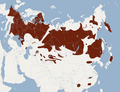
Common crane range map
-
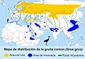 current map
 -
 Same map


- Article(s)
- Common crane
- Request
- Current map seems to be outdated, source is dead. This map [4] from International Crane Foundation is from 2019 can be used as a source for update. Thanks! Artem.G (talk) 08:11, 23 January 2023 (UTC)
- Discussion
Oceania map change centering
-
 Current map of Oceania
 -
 New map
.svg)
.svg)
- Article(s)
- Oceania
- Request
- The current map of Oceania is centered around the country of Australia, can someone change the map so it is centered around the geographic center of Oceania instead? Also, the current map has some islands that are a part of Oceania that are not colored in green. For example, Polynesia is a part of Oceania and only a few of its islands are colored green, and most of its islands aren't even visible on the map due to the way it is centered around Australia instead of the geographic center of Oceania when they could be visible if it was centered correctly. Even then some of the Polynesian islands that are currently visible on the map aren't colored green such as the Hawaiian Archipelago. The geographic center of Oceania is 13°21′S 178°9′W / 13.350°S 178.150°W. -- Treetoes023 (talk) 17:21, 7 March 2023 (UTC)
- Discussion
 Request taken by M.Bitton (talk) 17:23, 7 March 2023 (UTC).
- @Treetoes023: Done. M.Bitton (talk) 15:48, 12 March 2023 (UTC)
- Congratulations, everybody, on changing a map (mostly) of Oceania to a new map (almost completely) of sea. D'oh! SN54129 16:11, 12 March 2023 (UTC)
- The map hasn't been changed. The requested map was uploaded as a new one and it's up to the editors to decide whether they want to use it or not. Oceania is obviously mostly sea, so I don't see how else one is supposed to show, not just part of most most of it, but all of it, without exposing it for what it is. Suggestions on how to achieve that would be greatly appreciated. M.Bitton (talk) 17:32, 12 March 2023 (UTC)
- @M.Bitton: Thank you very much! Treetoes023 (talk) 18:26, 12 March 2023 (UTC)
- Congratulations, everybody, on changing a map (mostly) of Oceania to a new map (almost completely) of sea. D'oh! SN54129 16:11, 12 March 2023 (UTC)
- @Treetoes023:
{{resolved}}
Change the color of the non-contiguous landmasses of Afro-Eurasia to a lighter green in both maps
-
 Orthographic projection of Afro-Eurasia with national borders.
 -
 Orthographic projection of Afro-Eurasia without national borders.
 -
 Example image; the contiguous landmass of Afro-Eurasia is dark green, while the non-contiguous landmasses of Afro-Eurasia are a lighter green.
_political.svg)
_blank.svg)

- Article(s)
- Afro-Eurasia
- Request
- Keep the contiguous landmass of Afro-Eurasia the same color, but change the color of the non-contiguous landmasses of Afro-Eurasia to a lighter green like the example image. -- Treetoes023 (talk) 18:39, 14 March 2023 (UTC)
- Discussion
- Question: why are the islands highlighted? M.Bitton (talk) 19:13, 14 March 2023 (UTC)
- @M.Bitton: There are 2 commonly used definitions of Afro-Eurasia, in the first definition Afro-Eurasia is defined as the combination of the landmasses Africa and Eurasia including adjacent islands. In the second definition Afro-Eurasia is defined as the largest contiguous/continuous landmass in the world or a combination of the landmasses Eurasia and Africa not including adjacent islands. I think that the maps should include both definitions. Treetoes023 (talk) 22:38, 14 March 2023 (UTC)
- I don't see these two definitions in the article. This reliable source only supports the first definition. Do you have a reliable source that supports the second? M.Bitton (talk) 23:40, 14 March 2023 (UTC)
- @M.Bitton: I apologize, I was incorrect. The the second definition refers to the term "World Island", which is mentioned in the article and redirects to it. The term is still closely related so I think including the World Island definition in the maps still has merit as long as it is mentioned in the captions. Treetoes023 (talk) 12:26, 15 March 2023 (UTC)
- @Treetoes023: World island is indeed mentioned in the article, but as a different concept. The redirect is wrong (it should be to The Geographical Pivot of History). M.Bitton (talk) 15:01, 15 March 2023 (UTC)
- @M.Bitton: Okay, I fixed the redirects. Treetoes023 (talk) 15:18, 15 March 2023 (UTC)
- @Treetoes023: World island is indeed mentioned in the article, but as a different concept. The redirect is wrong (it should be to The Geographical Pivot of History). M.Bitton (talk) 15:01, 15 March 2023 (UTC)
- @M.Bitton: I apologize, I was incorrect. The the second definition refers to the term "World Island", which is mentioned in the article and redirects to it. The term is still closely related so I think including the World Island definition in the maps still has merit as long as it is mentioned in the captions. Treetoes023 (talk) 12:26, 15 March 2023 (UTC)
- I don't see these two definitions in the article. This reliable source only supports the first definition. Do you have a reliable source that supports the second? M.Bitton (talk) 23:40, 14 March 2023 (UTC)
- @M.Bitton: There are 2 commonly used definitions of Afro-Eurasia, in the first definition Afro-Eurasia is defined as the combination of the landmasses Africa and Eurasia including adjacent islands. In the second definition Afro-Eurasia is defined as the largest contiguous/continuous landmass in the world or a combination of the landmasses Eurasia and Africa not including adjacent islands. I think that the maps should include both definitions. Treetoes023 (talk) 22:38, 14 March 2023 (UTC)
{{resolved}}
-
 Area code map in North Carolina.
- Article(s)
- List of North Carolina area codes, Area codes 910 and 472, etc...
- Request
- In 2022, the area code of 910 gained a concurrent code of 472. Could this map be updated to show that change? Thank you for your time and have a good day! -- DiscoA340 (talk) 22:48, 14 March 2023 (UTC)
- Discussion
- @DiscoA340: this is a simple task that you can do all by yourself: download the map and open it using a good text editor. Search for the number that you're after "
910</tspan>" and replace it with "472</tspan>". Save and upload the updated map. M.Bitton (talk) 23:35, 14 March 2023 (UTC)
- @M.Bitton I just tried to do it and I'm hopeless. I found where "910" was in the code but it seems it will would take a few more lines to make "472" drop below it like the others in the image. Sorry about that. DiscoA340 (talk) 23:54, 14 March 2023 (UTC)
- @DiscoA340: Maybe I misunderstood what you're after. If by "drop below it" you mean you want to add it as a second number, then that's a different story. M.Bitton (talk) 23:58, 14 March 2023 (UTC)
{{resolved}}
File:Oceanodroma markhami map.svg simple crop
-
 Range map of Oceanodroma markhami

- Article(s)
- Oceanodroma markhami
- Request
- Can someone crop File:Oceanodroma markhami map.svg to its range off the coast of South America and up north to Baja California? Please include South America in the photo. Thank you. Perhaps upload as a new file. -- Therapyisgood (talk) 05:23, 31 January 2023 (UTC)
- Discussion
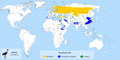
Map of countries with death penalties for atheism
-
 map
map

.svg)
.png)
![[4]](https://savingcranes.org/wp-content/uploads/2022/05/eurasian_cranes_v2_1000.jpg)
.svg)
- Article(s)
- Discrimination against atheists
- Request
- Sudan went secular and removed provisions for apostasy from Islam punishment from its penal code, see Freedom of religion in Sudan. The map is to be updated to reflect this reality -- Fixmaster (talk) 11:31, 3 March 2023 (UTC)
- Discussion
{{resolved}}