
Wikipedia:Graphics Lab/Map workshop/Archive/Mar 2023
| This page is an archive. Do not edit the contents of this page. Please direct any additional comments to the current main page. |
 | Archives of 2023: January, February, March, April, May, June, July, August, September, October, November, December |
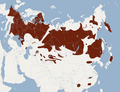
Nutria range map
-
 Current map
 -
 The range of the Nutria RegionsExtant (resident)Extant & Introduced (resident)CountriesExtant & Introduced (resident)Extant (resident)Extant & Introduced


- Article(s)
- Nutria
- Request
- Current nutria range map seems to be outdated as its source is from 2005. The best modern source I've found is this one: [1]. Maybe 'potential current distribution' can be added in a different colour? Artem.G (talk) 20:48, 12 April 2023 (UTC)
- Discussion
 Request taken by M.Bitton (talk) 19:45, 14 April 2023 (UTC).
 Done @Artem.G: M.Bitton (talk) 15:06, 15 April 2023 (UTC)
- hey, thanks! I've checked the iucn website, and under geographical details there are these countries:
- Extant & Introduced (resident) Austria; Belgium; Czechia; Denmark; France (France (mainland)); Germany; Greece (Greece (mainland)); Hungary; Italy (Italy (mainland)); Netherlands; Norway; Poland; Romania; Spain (Spain (mainland)); Sweden; Switzerland; United Kingdom
- hey, thanks! I've checked the iucn website, and under geographical details there are these countries:
- Extant & Introduced Japan; United States
- Can you please add them to the map? Artem.G (talk) 15:17, 15 April 2023 (UTC)
- I'm not exactly sure what you mean by adding them or how that could be achieved, as simply adding the countries (without a range) would be misleading at best (probably the reason they are not shown on their map). M.Bitton (talk) 15:22, 15 April 2023 (UTC)
- I understand that concern, but current map can is also misleading because it shows the range to be only in South America, while there is a lot of data and observations saying otherwise. I'll try to find another source that gives an introduced range. Artem.G (talk) 16:49, 15 April 2023 (UTC)
- One possible way to do it would be to highlight the countries and add a note explaining that it's been introduced there, something like:
- Countries where is has been introduced
- Let me know if that works for you. M.Bitton (talk) 17:10, 15 April 2023 (UTC)
- I understand that concern, but current map can is also misleading because it shows the range to be only in South America, while there is a lot of data and observations saying otherwise. I'll try to find another source that gives an introduced range. Artem.G (talk) 16:49, 15 April 2023 (UTC)
- I'm not exactly sure what you mean by adding them or how that could be achieved, as simply adding the countries (without a range) would be misleading at best (probably the reason they are not shown on their map). M.Bitton (talk) 15:22, 15 April 2023 (UTC)
- Can you please add them to the map? Artem.G (talk) 15:17, 15 April 2023 (UTC)
{{resolved}}
Common crane range map
-
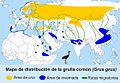 current map
 -
 Same map
 -
 Finished mapExtant (non-breeding)Extant (resident)Extant (breeding)


- Article(s)
- Common crane
- Request
- Current map seems to be outdated, source is dead. This map [3] from the International Crane Foundation from 2019 can be used as a source for update. Thanks! Artem.G (talk) 20:48, 12 April 2023 (UTC)
- Discussion
- I'll look into it. M.Bitton (talk) 21:27, 12 April 2023 (UTC)
- Request taken by M.Bitton (talk) 16:12, 13 April 2023 (UTC).
- Done @Artem.G:. M.Bitton (talk) 18:36, 14 April 2023 (UTC)
{{Resolved}}
Map for the Bee Branch
- Article(s)
- Bee Branch Creek (Iowa)
- Request
- I want a map of the course of the Bee Branch. I previously had one but I screwed up on the copyright and the owner stopped responding to me. The USGS [4] has a decent course till a detention basin where it goes underground. Afterwards, it has not been updated to include the daylighted segments. There are still sections of the Bee Branch that have not been daylighted and I am unsure how that section would be executed. OSM [5] does have the rest of the creek. -- ✶Mitch199811✶ 18:08, 3 March 2023 (UTC)
- Discussion
Muskrat range map
-
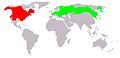 current image
 -
-

-

-
-
 Range of the MuskratExtant (resident)Extant & Reintroduced (resident)


- Article(s)
- Muskrat
- Request
- Current image (first one) is tiny and of bad quality, with no source for its data. Other images can be used for updated map, and also this [6] can help. Thanks! Artem.G (talk) 20:48, 12 April 2023 (UTC)
- Discussion
- Request taken by M.Bitton (talk) 00:35, 17 April 2023 (UTC).
- Please note that I will be basing it on the IUCN's map (which is similar to the first map that you cited). M.Bitton (talk) 00:37, 17 April 2023 (UTC)
- Done M.Bitton (talk) 16:28, 17 April 2023 (UTC)
Percent of scheduled tribes in India by tehsils by census 2011
-
 Percent of scheduled tribes in India by tehsils by census 2011

- Article(s)
- Scheduled Castes and Scheduled Tribes
- Request
- Need to Make more visible indian states boundaries. Now It is hard to distinguish state and district boundaries. -- Kaiyr (talk) 19:16, 10 March 2023 (UTC)
- Discussion
Comparison of polyhedral map projections

- Article(s)
- polyhedral map projection, Dymaxion map
- Request
- The above articles would highly benefit from having an image similar to http://images.newscientist.com/wp-content/gallery/unfolding-the-earth/00335340658.jpg showing how polyhedral world maps can be developed from the convex regular polyhedra.
- Would anyone feel inclined to vectorise the above (with significant changes such as 3D rotation of the polyhedra to avoid copyright issues)?
Maps displaying the Asian and European parts of Azerbaijan, Georgia, and Kazakhstan
-
 Example image showing the African and Asian parts of Egypt

- Article(s)
- List of transcontinental countries
- Request
- Make maps displaying the Asian and European parts of Azerbaijan, Georgia, and Kazakhstan in the same style as the example image showing the African and Asian parts of Egypt.
- Here is how the border between the Asian and European parts of each country is defined:
- Azerbaijan
- Asian part: Land south of the Greater Caucasus Watershed.
- European part: Land north of the Greater Caucasus Watershed.
- Georgia
- Asian part: Land south of the Greater Caucasus Watershed.
- European part: Land north of the Greater Caucasus Watershed.
- Kazakhstan
- Asian part: Land east of the Ural River.
- European part: Land west of the Ural River.
- -- Treetoes023 (talk) 16:11, 14 March 2023 (UTC)
- Discussion
Map displaying the North American and South American parts of Panama
-
Example image showing the African and Asian parts of Egypt
- Article(s)
- List of transcontinental countries
- Request
- Make a map displaying the North American and South American parts of Panama in the same style as the example image showing the African and Asian parts of Egypt. -- Treetoes023 (talk) 15:23, 15 March 2023 (UTC)
- Discussion
Illustration for 'Creation of Yugoslavia'
- Article(s)
- Creation of Yugoslavia
- Request
Recreate white arrows similar to ones in this copyrighted image onto one map, so the current illustration can be replaced. I'm having difficulties making proper curved arrows in Inkscape, so I'd appreciate a lot if someone else was up to this. ^^ –Vipz (talk) 04:30, 16 March 2023 (UTC)
- Discussion
![]() Request taken by M.Bitton (talk) 14:14, 16 March 2023 (UTC).
Request taken by M.Bitton (talk) 14:14, 16 March 2023 (UTC).
@Vipz: to avoid overwriting the used map, here's what I suggest you do:
1) create a new svg file (arrows.svg) using the following:
<svg width="1064.7" height="771.03" version="1.0" xmlns="http://www.w3.org/2000/svg">
    <defs>
        <marker id="a" overflow="visible" orient="auto">
            <path d="M-1.926-1.21 1.352-.005l-3.278 1.206a2.05 2.05 0 0 0 0-2.411z" fill="#fff" stroke="none"/>
        </marker>
    </defs>
    <rect width="1064.7" height="771.03" style="fill:none;stroke-width:1;stroke:#000" />
    <g id="arrows" fill="none" stroke="#fff" stroke-miterlimit="0" stroke-width="20">
        <path d="m674.37 529.9 82.412-131.97" marker-end="url(#a)"/>
        <path d="M711.51 159.42c89.897 68.683 74.406 123.04 35.103 179.55" marker-end="url(#a)"/>
    </g>
</svg>
2) open the target map in inkscape, create a new layer and import arrows.svg into it.
3) after aligning the two maps, delete the rectangle with a black border (used solely for the alignment).
4) using the node tool, click on the arrows to see the handles that will allow you to adjust the arrows however you wish.
If for whatever reason the above doesn't work or you simply don't want to go through the hassle of doing it, upload the map under a new name and I will happily overwrite it with the one that you're after (it's ready and will only take seconds to upload). M.Bitton (talk) 23:14, 16 March 2023 (UTC)
- Thank you so much! I think I will be able to do with this, but later down the day. I'll notify you if I happen to have further problems or requests/questions. –Vipz (talk) 09:02, 17 March 2023 (UTC)
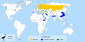
Members of International Astronomical Union update


- Article(s)
- International Astronomical Union
- Request
- Vietnam, Venezuela, Peru, Lebanon, North Korea, Iran, and Saudi Arabia are suspended members, maps should be updated - on the first one all these countries should be red, on the second - grey. Mongolia should be proper green, as it's a member state. Source [7]. Cuba should be removed from the second map , per [8]. Thanks! Artem.G (talk) 07:18, 4 May 2023 (UTC)
- Discussion
![]() Request taken by Dragon401k (talk) 17:40, 4 May 2023 (UTC).
Request taken by Dragon401k (talk) 17:40, 4 May 2023 (UTC).
- @Artem.G I updated the first map with information from the IAU membership page (Note that Mongolia is still an interim member-- you have to click on the national member's page to see whether they're a full member, interim or observer [9]). I also changed the colors to be colorblind friendly, and replaced the basemap with the most up-to-date version of the Blank World Map, which is human-editable plain text-- this should make it easier to update in the future. Note that any wiki articles which added separate color legends will need to be updated to reflect the new colors.
- You requested the second map be updated to include suspended members in grey, but I'm not sure that's helpful. Right now, it only includes full members. If it were to include suspended members, it would make sense to include interim and observer members as well, and then at that point it's just a clone of the first map. How would you feel about updating it to be up-to-date with the most recent base map, but still only including full national members? — Preceding unsigned comment added by Dragon401k (talk • contribs) 18:35, 4 May 2023 (UTC)
- You're right, let's keep it simple. I just thought that it can be useful because suspended members are still mentioned on the official site, but simplicity is better. And thanks a lot for the first map, looks good! Artem.G (talk) 18:44, 4 May 2023 (UTC)
- Done Dragon401k (talk) 19:29, 4 May 2023 (UTC) Updated the second map!
- You're right, let's keep it simple. I just thought that it can be useful because suspended members are still mentioned on the official site, but simplicity is better. And thanks a lot for the first map, looks good! Artem.G (talk) 18:44, 4 May 2023 (UTC)
{{resolved}}
NZ Map
-
 Finished map

- Article(s)
- New Zealand First
- Populism in New Zealand
- 2014 New Zealand general election
- Request
- Hi i just wondering can somebody make a map of electorate results of New Zealand First from the 2014 New Zealand general election.
- Auckland Central NZ First got 5.18
- Bay of Plenty NZ First got 13.94
- Botany NZ First got 5.44
- Christchurch Central NZ First got 7.19
- Christchurch East NZ First got 9.45
- Clutha-Southland NZ First got 6.24
- Coromandel NZ First got 12.50
- Dunedin North NZ First got 6.75
- Dunedin South NZ First got 9.11
- East Coast NZ First got 11.84
- East Coast Bays NZ First got 5.96
- Epsom NZ First got 3.48
- Hamilton East NZ First got 7.14
- Hamilton West NZ First got 10.82
- Helensville NZ First got 7.38
- Hunua NZ First got 9.58
- Hutt South NZ First got 7.48
- Ilam NZ First got 5.12
- Invercargill NZ First got 11.16
- Kaikōura NZ First got 9.85
- Kelston NZ First got 8.45
- Mana NZ First got 6.80
- Māngere NZ First got 7.35
- Manukau East NZ First got 7.80
- Manurewa, got 9.49
- Maungakiekie, got 6.61
- Mount Albert, got 4.11
- Mount Roskill, got 5.32
- Napier, got 7.43
- Nelson, got 7.67
- New Lynn got 7.18
- New Plymouth got 9.04
- North Shore got 5.83
- Northcote got 7.32
- Northland got 12.79
- Ōhariu got 4.77
- Ōtaki got 9.96
- Pakuranga got 7.11
- Palmerston North got 8.66
- Papakura got 10.81
- Port Hills got 6.62
- Rangitata got 7.87
- Rangitīkei got 11.29
- Rimutaka got 10.28
- Rodney got 9.09
- Rongotai got 5.44
- Rotorua got 12.20
- Selwyn got 6.95
- Tāmaki got 4.42
- Taranaki-King Country got 9.48
- Taupō got 10.29
- Tauranga got 14.50
- Te Atatū got 8.41
- Tukituki got 7.60
- Upper Harbour got 6.95
- Waikato got 10.79
- Waimakariri got 8.47
- Wairarapa got 11.74
- Waitaki got 6.97
- Wellington Central got 3.58
- West Coast-Tasman got 8.71
- Whanganui got 11.96
- Whangarei got 13.40
- Wigram got 8.56
- Hauraki-Waikato got 13.37
- Ikaroa-Rāwhiti got 11.42
- Tāmaki Makaurau got 14.12
- Te Tai Hauāuru got 11.79
- Te Tai Tokerau got 14.55
- Te Tai Tonga got 12.89
- Waiariki got 12.67
La lopi (talk) 06:17, 2 April 2023 (UTC) ???La lopi (talk) 10:30, 24 April 2023 (UTC)
- Discussion
![]() Request taken by Dragon401k (talk) 18:07, 5 May 2023 (UTC).
Request taken by Dragon401k (talk) 18:07, 5 May 2023 (UTC).
- @La lopi Done Dragon401k (talk) 19:28, 5 May 2023 (UTC)
- @Dragon401k Thanks, The Map looks good.La lopi (talk) 10:21, 6 May 2023 (UTC)
{{Resolved}}
Quick Map Update

- Article(s)
- Opinion polling for the 2024 Republican Party presidential primaries
- Request
- Hi i just wondering can somebody update this map. The update is Florida, Georgia, Kentucky, North Carolina, Pennsylvania, Tennessee are for Trump and Utah is now for DeSantis.La lopi (talk) 08:22, 9 May 2023 (UTC)
- Discussion
@La lopi: ![]() Done —twotwofourtysix(talk || edits) 10:32, 9 May 2023 (UTC)
@Twotwofourtysix: Thanks.{{resolved}} La lopi (talk) 11:55, 9 May 2023 (UTC)
Done —twotwofourtysix(talk || edits) 10:32, 9 May 2023 (UTC)
@Twotwofourtysix: Thanks.{{resolved}} La lopi (talk) 11:55, 9 May 2023 (UTC)
Maps in Hungarian nobility
-
 Hungary in the 11th century
 -


- Article
- Hungarian nobility
- Request
- During the FAC review of Hungarian nobility, Nikkimaria noted that "Maps are illegible at current size, and see MOS:COLOUR". The article contains the maps presented above. As I have no experience with map making, I would be grateful if an expert could fix the problems with the maps. I would be grateful for your assistance. Thank you for your time. Borsoka (talk) 05:20, 25 March 2023 (UTC)
- Discussion
Interactive maps
I have been working on rebuilding the Flemington Racecourse railway line and Williamstown railway line articles. Two requests:
- The Flemington Racecourse article doesn't have an interactive map- can someone please create one and add it in?
- Also, the Williamstown article does have an interactive map but for some reason it doesn't display correctly- can someone please fix this?
I need these two requests to be fulfilled so I can nominate the two articles for Good Article status. Thanks in advance for all the help. HoHo3143 (talk) 03:11, 8 May 2023 (UTC)
- Discussion
These interactive maps are created by calling the railway line's Wikidata ID, which has geodata associated with it. It looks like in the case of the Melbourne railway network lines, the geodata is associated with the Freebase ID. (This is just an inference on my part, I could be totally wrong, but I can't figure out where else the geodata word be stored, as its not in any of the other properties).
The Williamstown article was calling a wikidata ID for Williamstown that didn't have a Freebase ID attached, Williamstown railway line (Q8021313). I was able to fix the map by having it call Williamstown (Q55509933) instead.
Flemington Racecourse railway line (Q5458622) has a Freebase ID, but for whatever reason, it doesn't show up when I try to create an interactive map that calls it, so I'm not sure what to do there. Maybe someone else has a better idea? Dragon401k (talk) 15:58, 8 May 2023 (UTC)
- @Dragon401k thanks for the help. For the Williamstown line, the map only shows part of the line- is this supposed to be this way? If it is displaying "correctly", could you make the map longer so it makes its way into the cbd (use the map on the Werribee line as a reference)
- Also thanks for looking into the FR line. Hopefully someone else can help out. HoHo3143 (talk) 01:40, 9 May 2023 (UTC)
- I've finished another article and am waiting on these two maps to nominate these two articles- could someone help please? HoHo3143 (talk) 11:52, 11 May 2023 (UTC)
Map format change request


- Article(s)
- Sindhis
- Request
- Need somebody to convert my map from .PNG format to .SVG format. -- ⭐️ Starkex ⭐️ 📧 ✍️ 11:20, 21 April 2023 (UTC)
- Discussion
![]() Request taken by Dragon401k (talk) 01:27, 2 May 2023 (UTC).
Request taken by Dragon401k (talk) 01:27, 2 May 2023 (UTC).
- Done Dragon401k (talk) 02:04, 2 May 2023 (UTC)
- @Dragon401k, Hey that is an amazing work! Thanks for helping out and best wishes. ⭐️ Starkex ⭐️ 📧 ✍️ 15:38, 7 May 2023 (UTC)
{{resolved}}
Request for map of the Angevin Empire
-
 Red and green map of the Angevin Empire in France
.svg)
![[3]](https://savingcranes.org/wp-content/uploads/2022/05/eurasian_cranes_v2_1000.jpg)
- Article(s)
- Henry II of England
- Request
- At Henry II's FA nomination, a reviewer requested that the map be adjusted according to MOS:COLOUR. User:A455bcd9 said " tried and... I couldn't modify the image. I'm not an expert at all in Inkscape and I thought I could manage but it's beyond my (poor) skills. And yet it should be simple: we just want to replace green-ish areas by another color (yellow? purple?). It may be faster to ask the Wikipedia:Graphics Lab/Map workshop". Thank you for your generosity and assistance. -- Unlimitedlead (talk) 12:49, 2 May 2023 (UTC)
- Discussion
@Unlimitedlead: ![]() Done Dragon401k (talk) 05:16, 4 May 2023 (UTC) Apologies for the triple upload, I got spooked by the image not updating upon refresh, reverted it, then realized it had uploaded properly the first time.
Done Dragon401k (talk) 05:16, 4 May 2023 (UTC) Apologies for the triple upload, I got spooked by the image not updating upon refresh, reverted it, then realized it had uploaded properly the first time.
- @Dragon401k Thank you so much. It looks fantastic! Unlimitedlead (talk) 10:48, 4 May 2023 (UTC)
{{resolved}}