
Ajuria
Ajuria | |
|---|---|
Village | |
 Ajuria Location in West Bengal, India  Ajuria Ajuria (India) | |
| Coordinates: 22°31′42″N 87°46′46″E / 22.5284°N 87.7794°E | |
| Country | |
| State | West Bengal |
| District | Paschim Medinipur |
| Population (2011) | |
| • Total | 1,811 |
| Languages | |
| • Official | Bengali, English |
| Time zone | UTC+5:30 (IST) |
| PIN | 721146 |
| Telephone/STD code | 03225 |
| Lok Sabha constituency | Ghatal |
| Vidhan Sabha constituency | Daspur |
| Website | paschimmedinipur |
Ajuria (also spelled Ajurya) is a village in the Daspur II CD block in the Ghatal subdivision of the Paschim Medinipur district in the state of West Bengal, India.
Geography[edit]

5miles
M: municipal city/ town, R: rural/ urban centre, H: historical/ religious centre
Owing to space constraints in the small map, the actual locations in a larger map may vary slightly
Location[edit]
Ajuria is located at 22°31′42″N 87°46′46″E / 22.5284°N 87.7794°E.
Area overview[edit]
Ishwar Chandra Vidyasagar, scholar, social reformer and a key figure of the Bengal Renaissance, was born at Birsingha on 26 September 1820.[1][2]
Ghatal subdivision, shown in the map alongside, has alluvial soils. Around 85% of the total cultivated area is cropped more than once.[3] It has a density of population of 1,099 per km2, but being a small subdivision only a little over a fifth of the people in the district reside in this subdivision. 14.33% of the population lives in urban areas and 86.67% lives in the rural areas.[4]
Note: The map alongside presents some of the notable locations in the subdivision. All places marked in the map are linked in the larger full screen map.
Demographics[edit]
According to the 2011 Census of India, Ajurya had a total population of 1,811, of which 917 (51%) were males and 894 (49%) were females. There were 190 persons in the age range of 0–6 years. The total number of literate persons in Ajurya was 1,355 (83.59% of the population over 6 years).[5]
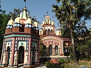
Ajuria picture gallery[edit]
-
 nava-ratna Lakshmi Janardana temple of Charan family, built in 1793
 -
 Lakshmi Janardana temple and rasmancha with figurines of musicians
 -
 Terracotta relief


References[edit]
- ^ Murshid, Ghulam. "Vidyasagar, Pundit Iswar Chandra". Banglapedia. Retrieved 24 July 2016.
- ^ "Ishwar Chandra Vidyasagar". www.whereincity.com. Retrieved 24 July 2016.
- ^ "District Human Development Report Paschim Medinipur, 2011". page 27-28. Department of Planning and Statistics, Government of West Bengal. Retrieved 10 September 2020.
- ^ "District Statistical Handbook Paschim Medinipur, 2013". Table 2.2, 2.4 (a). Department of Planning and Statistics. Retrieved 10 September 2020.
- ^ "CD block Wise Primary Census Abstract Data(PCA)". West Bengal – District-wise CD blocks. Registrar General and Census, India. Retrieved 24 August 2020.
