
Radhakantapur
Radhakantapur | |
|---|---|
Village | |
 Radhakantapur Location in West Bengal, India  Radhakantapur Radhakantapur (India) | |
| Coordinates: 22°33′37″N 87°44′39″E / 22.5603°N 87.7441°E | |
| Country | |
| State | West Bengal |
| District | Paschim Medinipur |
| Population (2011) | |
| • Total | 2,473 |
| Languages | |
| • Official | Bengali, English |
| Time zone | UTC+5:30 (IST) |
| PIN | 721211 |
| Telephone/STD code | 03225 |
| Lok Sabha constituency | Ghatal |
| Vidhan Sabha constituency | Daspur |
| Website | paschimmedinipur |
Radhakantapur is a village in the Daspur I CD block in the Ghatal subdivision of the Paschim Medinipur district in the state of West Bengal, India.
Geography[edit]

5miles
M: municipal city/ town, R: rural/ urban centre, H: historical/ religious centre
Owing to space constraints in the small map, the actual locations in a larger map may vary slightly
Location[edit]
Radhakantapur is located at 22°33′37″N 87°44′39″E / 22.5603°N 87.7441°E.
Area overview[edit]
Ishwar Chandra Vidyasagar, scholar, social reformer and a key figure of the Bengal Renaissance, was born at Birsingha on 26 September 1820.[1][2]
Ghatal subdivision, shown in the map alongside, has alluvial soils. Around 85% of the total cultivated area is cropped more than once.[3] It has a density of population of 1,099 per km2, but being a small subdivision only a little over a fifth of the people in the district reside in this subdivision. 14.33% of the population lives in urban areas and 86.67% lives in the rural areas.[4]
Note: The map alongside presents some of the notable locations in the subdivision. All places marked in the map are linked in the larger full screen map.
Demographics[edit]
According to the 2011 Census of India, Radhakantapur had a total population of 2,473, of which 1,242 (50%) were males and 1,231 (50%) were females. There were 281 persons in the age range of 0–6 years. The total number of literate persons in Radhakantapur was 1,749 (79.79% of the population over 6 years).[5]
Education[edit]
Radhakantapur High School is a Bengali-medium coeducational institution established in 1966. The school has facilities for teaching from class V to class XII. It has a library with 612 books, 1 computer and a playground.[6]
Culture[edit]
David J. McCutchion classifies the Gopinath (mentioned as Panchananda) temple as an ek-ratna of the smaller Daspur type, measuring 22’ x 28’, with rich terracotta façade. He classifies the Dadhibamna temple (name not mentioned, only place mentioned) as a richly decorated pancha-ratna with smooth rekha turrets.[7]
The Gopinath temple is a state protected monument.[8]
Radhakantapur picture gallery[edit]
-
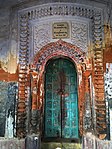
 Ek-ratna Gopinath temple, established in 1844 and owned by the Das family
 -
 Terracotta panel
 -
 Terracotta relief
 -
 Pancha-ratna Dadhi Bamna temple, established in 1770 and owned by the Bose family.
 -
 Not much terracotta remains in the Dadhi Bamna temple. This picture shows some stucco decoration.


References[edit]
- ^ Murshid, Ghulam. "Vidyasagar, Pundit Iswar Chandra". Banglapedia. Retrieved 24 July 2016.
- ^ "Ishwar Chandra Vidyasagar". www.whereincity.com. Retrieved 24 July 2016.
- ^ "District Human Development Report Paschim Medinipur, 2011". page 27-28. Department of Planning and Statistics, Government of West Bengal. Retrieved 10 September 2020.
- ^ "District Statistical Handbook Paschim Medinipur, 2013". Table 2.2, 2.4 (a). Department of Planning and Statistics. Retrieved 10 September 2020.
- ^ "CD block Wise Primary Census Abstract Data(PCA)". West Bengal – District-wise CD blocks. Registrar General and Census, India. Retrieved 21 August 2020.
- ^ "Radhakantapur H.S. U.Pry". Schools.org. Retrieved 21 August 2020.
- ^ McCutchion, David J., Late Mediaeval Temples of Bengal, first published 1972, reprinted 2017, pages 43, 49. The Asiatic Society, Kolkata, ISBN 978-93-81574-65-2
- ^ List of State Protected Monuments as reported by the Archaeological Survey of India Archived 2013-05-23 at the Wayback Machine.
