Portal:Indiana
The Indiana Portal
Indigenous resistance to American settlement was broken with defeat of the Tecumseh's confederacy in 1813. The new settlers were primarily Americans of British ancestry from the eastern seaboard and the Upland South, and Germans. After the Civil War, in which the state fought for the Union, natural gas attracted heavy industry and new European immigrants to its northern counties. In the first half of the 20th century, northern and central sections experienced a boom in goods manufacture and automobile production. Southern Indiana remained largely rural.
Today, Indiana has a diverse economy with a gross state product in 2023 of 404.3 billion. It has several metropolitan areas with populations greater than 100,000 and a number of smaller cities and towns. Indiana is home to professional sports teams, including the NFL's Indianapolis Colts, the NBA's Indiana Pacers, and the WNBA's Indiana Fever. The state also hosts several notable competitive events, such as the Indianapolis 500, held at Indianapolis Motor Speedway. (Full article...)
Selected article -
The Indianapolis Motor Speedway is a motor racing circuit located in Speedway, Indiana, United States, an enclave suburb of Indianapolis, Indiana. It is the home of the Indianapolis 500 and the Brickyard 400 and formerly the home of the United States Grand Prix and Indianapolis motorcycle Grand Prix. It is located six miles (9.7 km) west of Downtown Indianapolis.
Constructed in 1909, it is the second purpose-built, banked oval racing circuit after Brooklands and the first to be called a 'speedway'. It is the third-oldest permanent automobile race track in the world, behind Brooklands and the Milwaukee Mile. With a permanent seating capacity of 257,325, it is the highest-capacity sports venue in the world. (Full article...)
Selected image -
 |
Did you know -
- ... that Lego Indiana Jones: The Original Adventures excludes mentions of Nazism that are present in the Indiana Jones films?
- ... that the Circle Tower, an Art Deco building in Indianapolis, features ziggurat-like upper floors?
- ... that an Indiana newspaper donated its TV station to the local high school instead of shutting it down?
- ... that after the Wolverines released their "Moose" for his fifth season, he went on to win another Big Ten championship with the Hoosiers?
- ... that the Leedy Manufacturing Company of Indianapolis, Indiana, was at one point the largest manufacturer of drums in the world?
- ... that an "army" of women were congratulated by Pat Nixon for their fundraising efforts to bring public TV to Indianapolis?
Related portals
Selected geographic article -
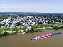
New Albany /ˈɑːlbəni/ is a city in Floyd County, Indiana, United States, situated along the Ohio River, opposite Louisville, Kentucky. The population was 37,841 as of the 2020 census. The city is the county seat of Floyd County. It is bounded by I-265 to the north and the Ohio River to the south, and is considered part of the Louisville metropolitan area. The mayor of New Albany is Jeff Gahan, a Democrat; he was re-elected in 2023. (Full article...)
Selected biography -
John Glover Roberts Jr. (born January 27, 1955) is an American jurist serving since 2005 as the 17th chief justice of the United States. He has been described as having a moderate conservative judicial philosophy, though he is primarily an institutionalist. Regarded as a swing vote in some cases, Roberts has presided over an ideological shift toward conservative jurisprudence on the high court, in which he has authored key opinions.
Born in Buffalo, New York, Roberts was raised Catholic in Northwest Indiana and studied at Harvard University with the initial intent to become a historian, graduating in three years with highest distinction, then attended Harvard Law School, where he was an editor of the Harvard Law Review. Before holding positions in the Reagan and senior Bush administration, Roberts served as a law clerk for Judge Henry Friendly and Justice William Rehnquist. From 1989 to 1993, he was Principal Deputy Solicitor General, after which he built a leading appellate practice and argued 39 cases before the Supreme Court. (Full article...)
Selected quote
General images
Topics
- Economy: AM General - ATA Airlines - Casinos - Cummins - Delta - ITT - JayC - Lilly - Limestone - Manufacturing - NiSource - Shoe Carnival - Simon Property Group - Soybeans - Studebaker - Vectren - WellPoint
- Geography: Caves - Lakes - Rivers - State forests - Watersheds
Categories
Attractions
 |
Recognized content
| This is a list of recognized content, updated weekly by JL-Bot (talk · contribs) (typically on Saturdays). There is no need to edit the list yourself. If an article is missing from the list, make sure it is tagged (e.g. {{WikiProject Indiana}}) or categorized correctly and wait for the next update. See WP:RECOG for configuration options. |
Good articles
- 1925 Tri-State tornado
- 1963 Indiana State Fairgrounds Coliseum gas explosion
- 2006 Brickyard 400
- 2011 South Bend mayoral election
- 2015 South Bend mayoral election
- 2019 South Bend mayoral election
- 2021 NCAA Division I men's basketball championship game
- Max Bielfeldt
- The Fault in Our Stars (film)
- Hurley Goodall
- R. Ames Montgomery
- Proposed South Shore Line station in South Bend
- Richmond, Indiana, facility fire
- WCAE
Featured pictures
-
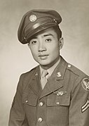
Kenje Ogata 1943
-
Kurt Vonnegut by Bernard Gotfryd (1965)
-
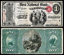
US-NBN-IL-Lebanon-2057-Orig-1-400-C
WikiProjects
State facts
Indiana | |
|---|---|
| Country | United States |
| Admitted to the Union | December 11, 1816 (19th) |
| Capital | Indianapolis |
| Largest city | Indianapolis |
| Largest metro and urban areas | Indianapolis-Carmel MSA |
| Government | |
| • Governor | Eric Holcomb (R) (2017) |
| • Lieutenant Governor | Suzanne Crouch (R) (2017) |
| Legislature | Indiana General Assembly |
| • Upper house | Senate |
| • Lower house | House of Representatives |
| U.S. senators | Todd Young (R) Mike Braun (R) |
| Population | |
• Total | 6,080,485 |
| • Density | 169.5/sq mi (65.46/km2) |
| Language | |
| • Official language | English |
| Latitude | 37° 46′ N to 41° 46′ N |
| Longitude | 84° 47′ W to 88° 6′ W |
Things you can do
 |
Here are some tasks awaiting attention:
|
Associated Wikimedia
The following Wikimedia Foundation sister projects provide more on this subject:
-
Commons
Free media repository -
Wikibooks
Free textbooks and manuals -
Wikidata
Free knowledge base -
Wikinews
Free-content news -
Wikiquote
Collection of quotations -
Wikisource
Free-content library -
Wikiversity
Free learning tools -
Wikivoyage
Free travel guide -
Wiktionary
Dictionary and thesaurus
- ^ a b "Elevations and Distances in the United States". U.S Geological Survey. 29 April 2005. Retrieved 2006-11-06.
{{cite web}}: CS1 maint: year (link)

