Langdon, is a neighborhood located in Ward 5 of Northeast Washington, D.C. Historical surveys of D.C. recognize Langdon as a neighborhood dating back to at least 1903. Langdon is bounded by Montana Ave. NE to the west/southwest, New York Ave. NE to the south, Bladensburg Rd. NE to the southeast, South Dakota Ave. NE to the northeast, and Rhode Island Ave. NE to the north/northwest. Langdon is adjacent to the Northeast D.C. neighborhoods of Brentwood (west), Woodridge (east), Fort Lincoln (southeast), Gateway (south), and Brookland (north). (Full article...)
Swampoodle was a neighborhood in Washington, D.C. on the border of Northwest and Northeast in the second half of 19th and early 20th century. This neighborhood is no longer known as Swampoodle and has been replaced in large part by NoMa. (Full article...)
Kenilworth is a residential neighborhood in NortheastWashington, D.C., located on the eastern bank of the Anacostia River and just inside the D.C.-Maryland border. A large public housing complex, Kenilworth Courts, dominates the area. The neighborhood is famous for the Kenilworth Park and Aquatic Gardens, a national park whose centerpiece is a series of ponds carved out of Anacostia River marshland. Visitors come especially during June and July to see the beautiful blooming water lilies and lotus flowers. In 1895 the name “Kenilworth” was first applied to the area by white real estate developer Allen Mallery, who named this neighborhood after Kenilworth Castle in England, the ruins of which can still be seen today in Warwickshire. Kenilworth Park, which includes the Kenilworth-Parkside Recreation Center, also carries the neighborhood name, though most of the park's area is actually located adjacent to the modern neighborhoods of Parkside and Eastland Gardens. (Full article...)
Image 6
Map of Washington, D.C., with the Marshall Heights neighborhood highlighted in red
Marshall Heights is a residential neighborhood in SoutheastWashington, D.C. It is bounded by East Capitol Street, Central Avenue SE, Southern Avenue, Fitch Street SE, and Benning Road SE. It was an undeveloped rural area occupied by extensive African Americanshanty towns, but the neighborhood received nationwide attention after a visit by First LadyEleanor Roosevelt in 1934, which led to extensive infrastructure improvements and development for the first time. In the 1950s, Marshall Heights residents defeated national legislation designed to raze and redevelop the neighborhood. Queen Elizabeth II of the United Kingdom visited the area in 1991, at a time when Marshall Heights was in the throes of a violent crack cocaine epidemic. Limited redevelopment has occurred in the neighborhood, which was the site of two notorious child murders in 1973. (Full article...)
Image 7
Intersection of Blaine St. and Burns St. NE, in East River Heights, May 2019
East River Heights is a residential and mixed use neighborhood located in Ward 7 of Washington, DC. It is considered the "downtown" area of the ward and has high walkability ratings. Its borders are East Capital Street, Minnesota Ave, Benning Road up to 41st Street. It is a neighborhood of retired and working people and many children. There is quite a bit of development occurring. The houses are small but have large yards. It is centrally located. It is located between the Minnesota Avenue and Benning Road stations on the Washington Metro. (Full article...)
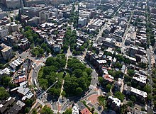
Logan Circle is a historic roundabout park and neighborhood of Washington, D.C., located in Northwest D.C. The majority of Logan Circle is primarily residential, except for the highly-commercialized 14th Street corridor that passes through the western part of the neighborhood. In the 21st century, Logan Circle has been the focus of urban redevelopment and become one of Washington's most expensive neighborhoods. Today, Logan Circle is also one of D.C.'s most prominent gay neighborhoods. (Full article...)
Image 10
Douglass within the District of Columbia
Douglass is a residential neighborhood in SoutheastWashington, D.C., on the eastern side of St. Elizabeths Hospital, on the border of the Congress Heights Metro Station. It is bounded by Suitland Parkway to the north and east, Alabama Avenue to the south, and the St. Elizabeths campus to the west. (Full article...)
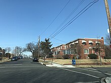
Intersection of 8th St and Crittenden St, NE, Michigan Park, February 2018 Michigan Park is a neighborhood in Ward 5 of NortheastWashington, D.C. in the Upper Northeast area element. The boundaries of Michigan Park and North Michigan Park neighborhoods are contested due to the history of racial disparity between the two, but in general Michigan Park is considered to be contained between South Dakota Avenue to the west, Eastern Avenue to the east, Galloway Street NE to the north and Taylor Street NE to the South. Both neighborhoods are in DC Neighborhood Cluster 20 along with the University Heights neighborhood. Michigan Park is home to two established Civic Associations: the North Michigan Park Civic Association which has its established boundaries that include both Michigan Park and North Michigan Park and the Queens Chapel Civic Association (that is separate from the Queens Chapel neighborhood which borders Michigan Park to the north). The Queens Chapel association meets regularly at Union Wesley African Methodist Zion Church and its boundaries are between 16th Street NE and Webster Street NE to the north, Michigan Avenue NE to the south, and South Dakota Avenue NE to the west. (Full article...)
Kent is a neighborhood in NorthwestWashington, D.C. in the United States, bounded by Loughboro Road to the north, MacArthur Boulevard to the southwest, and Chain Bridge Road and Battery Kemble Park to the southeast. It is a suburban neighborhood, home to some of the most expensive homes in the city with an average home sales price in 2012 of $1.7 million ($2.26 million today). (Full article...)


.jpg)


.jpeg)
.jpg)