
Solar eclipse of October 30, 1845
This article has multiple issues. Please help improve it or discuss these issues on the talk page. (Learn how and when to remove these template messages)
|
| Solar eclipse of October 30, 1845 | |
|---|---|
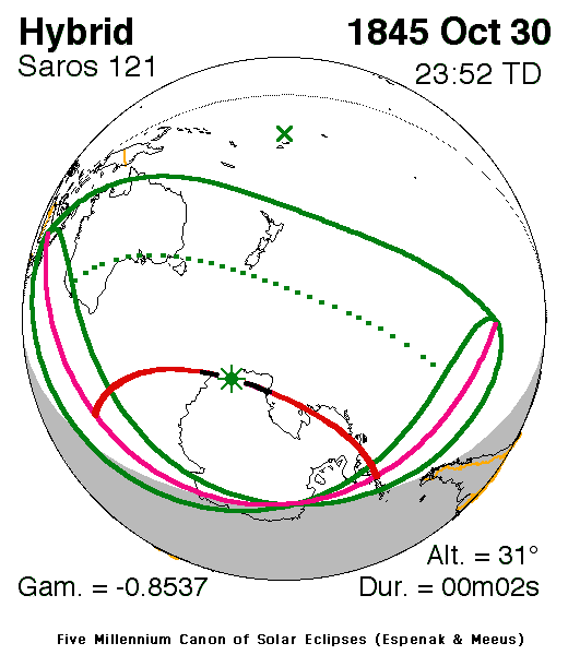
 Map | |
| Type of eclipse | |
| Nature | Hybrid |
| Gamma | −0.8538 |
| Magnitude | 1.0005 |
| Maximum eclipse | |
| Duration | 2 s (0 min 2 s) |
| Coordinates | 69°06′S 144°30′E / 69.1°S 144.5°E |
| Max. width of band | 3 km (1.9 mi) |
| Times (UTC) | |
| Greatest eclipse | 23:51:58 |
| References | |
| Saros | 121 (51 of 71) |
| Catalog # (SE5000) | 9153 |
A hybrid (annular/total) solar eclipse occurred on Thursday, October 30, 1845 during spring. A solar eclipse occurs when the Moon passes between Earth and the Sun, thereby totally or partly obscuring the image of the Sun for a viewer on Earth. A hybrid solar eclipse shifts between a total and annular eclipse. At certain points on the surface of Earth it appears as a total eclipse, whereas at other points it appears as annular. Hybrid eclipses are comparatively rare. This eclipse is a hybrid event, a narrow total eclipse, and beginning and ending as an annular eclipse.
The greatest eclipse was in northeasternmost Antarctica south of where the Indian and Pacific Ocean divides at 69.1 S and 144.5 E at 23:51 UTC (9:51 am on October 31), in that portion of Antarctica and the surrounding waters it shown as a total eclipse, the remainder was as an annular, first in the Indian Ocean then in the Antarctic Peninsula.[1]
Description[edit]
The eclipse was visible in the islands of Java, Bali, Sunda (the three compromising a part of Indonesia today) and Timor including Portuguese Timor (now East Timor), the Asian islands, almost the whole of Australia with the exception of the Cape York Peninsula, Lord Howe Island, Norfolk Island, Macquarrie Islands, New Zealand, Chatham Islands, Antipodes and some remaining small islands.
In Australia, it showed up to 10% obscuration in the south of the Gulf of Carpentaria, around 15% in Brisbane, 25–30% in Central Australia, around 40% in Sydney, 50% in Melbourne, around 55% in Tasmania and the Nullarbor Plain and around 60% in Perth, Western Australia. Elsewhere it showed 10% in the north tip of New Zealand's North Island, up to 30% in the area of Wellington, 45% in Otago. and 60% in the Chatham Islands. It was also around 90% in the shores of Western Antarctica and around the 180th meridian.
The rim of the eclipse included the area south of Cairns, Queensland, the Coral Sea and Cook Islands.
The eclipse started at sunrise in Western Australia and finished at sunset in the Antarctic Peninsula and southwest of Patagonia in South America.[1]
See also[edit]
References[edit]
- ^ a b "Solar eclipse of October 30, 1845". NASA. Retrieved March 18, 2017.
.jpg)

