
Talk:Control of cities during the Syrian civil war/Archive 10
| This is an archive of past discussions. Do not edit the contents of this page. If you wish to start a new discussion or revive an old one, please do so on the current talk page. |
| Archive 5 | ← | Archive 8 | Archive 9 | Archive 10 | Archive 11 | Archive 12 | → | Archive 15 |
New Color for J.Nusra
Use a new color to identify al nusra's occupied cities for further identification in the map. — Preceding unsigned comment added by 142.197.58.143 (talk) 16:20, 20 January 2014 (UTC)
Nusra is not at war with anyone so no need for that as they still fight along side other rebels.Daki122 (talk) 16:32, 20 January 2014 (UTC)
Yes I agree, they have a neutral position for the rebels-ISIS conflict and sometimes, there are even tensions between JAN and ISIS (remember, they killed JAN emir for Raqqah.) --Amedjay (talk) 16:40, 20 January 2014 (UTC)
Agree, they don't need to be separated from the rebels. EkoGraf (talk) 20:17, 20 January 2014 (UTC)
- Exactly. How else could the government-biased members keep calling rebels terrorists, without their JAN affiliated terror squads?Ariskar (talk) 20:25, 20 January 2014 (UTC)
- Even the ISIS has had difficulty matching the terrorism of the regime, never mind al-Nusra.
- That aside, al-Nusra has been fighting the ISIS as well as negociating their departure from various towns. Giving the few syrians in the ISIS the option of joining their forces, and in most cases disarming the others. It is the only group opposed to the ISIS that has much chance of succeeding, since a lot of the syrians in the ISIS were once part of al-Nusra.
- So I agree with EkoGraf that they don't need a separate colour. André437 (talk) 12:17, 21 January 2014 (UTC)
CONTESTED????
The towns which are contested between Assad and the rebels and the towns which are contested between the rebels and ISIS have the same colour,this is chaotic. we need another solution for this,thank you. Sascha,Germany, 84.171.36.249 (talk) 09:57, 21 January 2014 (UTC)
- War usually is chaotic. So, no surprises on how the map looks. EkoGraf (talk) 15:33, 21 January 2014 (UTC)
- Take a look at these icons for contested points on the map. (I posted having finished them sunday, but no one seems to have noticed.)
- There are 6 static (for all the possible 1-on-1 conflicts of the 4 colours), and 6 animated of 2 frames at intervals of 1 second.
- (There is also an animated 3-colour icon of 500ms intervals, for ambiguous conflicts.)
- Tell me if you prefer the static or animated versions, and I can install them for use on the map. André437 (talk) 11:46, 21 January 2014 (UTC)
Andre437, thank you for making those new icons. Great job! I think these will improve the map. I prefer the animated ones to represent current conflicts. The unanimated ones I think would intuitively appear to represent a more stable divided control of a locality. (I think the gifs are fine as designed, but I do wonder why they have a white box in the center.)Hulahoop122 (talk) 18:01, 21 January 2014 (UTC)
- You are right about the white box in the centre. It should have been black, to match the current multicoloured icon. (On the current icon, only the bottom layer has the centre in black, but it displays black in all layers.) I think it was meant to indicate conflict around the town.
- (I agree that the animation is better. I only wanted to present the alternative.)
- I'll fix that, and add the current icon for comparison. Then post here when ready. André437 (talk) 00:41, 22 January 2014 (UTC)
- OK, icons ready for viewing again, here.
- Your comments made me realize that probably the icons would be better if a bit simpler but animated, so I dropped the static icons and made 3 new sets, variations of the old. Details in my comment at the end of this section.
- Let me know what you think :) André437 (talk) 03:03, 23 January 2014 (UTC)
BREAKING NEWS! ISIS STORMING DIVISION 17 IN RAQQA SINCE THIS AFTERNOON!! WESTERN PART ALREADY SEIZED,HEAVY FIGHTING NOW IN THE EASTERN PARTS OF THE BASE!!!
https://www.facebook.com/syriaohr/posts/478145042293839
ACCORDING TO MY INFO SEVERAL THOUSAND ISIS-FIGHTERS TAKE PART AND THEY SIMPLY OVERRAN THE WESTERN PART OF THE BASE WITHIN 60 MINUTES,USING SUICIDE BOMBERS AND MANY TANKS!!
Sascha,Germany 84.171.36.249 (talk) 18:54, 21 January 2014 (UTC)
Getting excited so much because of an Al-Qaeda, not even a moderate rebel's, possible partial victory. Nice.... Also, your sources (vague and unreliable) as you put it is not accepted for edits on Wikipedia. EkoGraf (talk) 19:09, 21 January 2014 (UTC)
I agree to EkoGraf. Also if you dont know Facebook not reliable source. WP:FACEBOOK Hanibal911 (talk) 19:35, 21 January 2014 (UTC)
- Nice icons Andre437. I suggest it could prove a nice addition.Ariskar (talk) 00:58, 22 January 2014 (UTC)
- Glad you like them. I think I made them even better, if you would like to take another look. same place
- As before, it starts with the existing icon, then my 3-coloured icon. Followed by 6 with the border like before but solid centre ; then 6 without a border (and solid centre) l then 6 without border and a 2x2 hole in centre. My icons are all 8x8 (as before) with 1-second intervals between frames. So the choice is between which 6 look best. (I somewhat favour the second group.)
- Let me know what you think. André437 (talk) 03:03, 23 January 2014 (UTC)
Nice modifications. They are all good options. I would however advise against the one with the white border, as that is the same color as the background to the map, and would not be visible. The more I think about it, I think the version of the conflict icon without a black border might be the best. When these icons are reproduced very small, you want as much of the icon to have the colors of the two groups fighting, so that it can be easily identified. If there is a black border around it, that takes away from the available space to display those two colors. I'm looking forward to seeing how they look on the map. If most other posters agree, we might want to start with one of the less common conflicts (e.g. something like ISIS/Kurds) to try out how it looks. Hulahoop122 (talk) 17:12, 23 January 2014 (UTC)
- Well, I imported the second set, and did a little test with a copy of the current map, changing some conflict icons. test map here.
- As you can see in the Damascus area, without the black border the icons are completely mixed in with each other. So it looks like I have to modify the first set to have all black borders. (I had put white borders on those with the ISIS.)
- Note that I added a line in the index (of the test map) for the new conflict icons.
- Also note that the size in pixels is specified for each entry on the map.
- I'll post here when done. André437 (talk) 12:18, 24 January 2014 (UTC)
- Yes, I see now why those black or white borders are important, especially for the FSA/government conflicts where they often merge into each other, or where they are on top of a solid color (such as the red for the government in Homs). Great work! Hulahoop122 (talk) 15:25, 24 January 2014 (UTC)
Islamic Front declares that ISIS units consist of Iranians supporters of Assad and commander ISIS in town Jarablus is lieutenant of the Syrian army.World Bulletin Hanibal911 (talk) 19:23, 23 January 2014 (UTC)
- I would take that claim with a high degree of reservation. EkoGraf (talk) 19:24, 23 January 2014 (UTC)
- What the military leader of the Islamic Front actually is quoted to have said is that the regime has infiltrated the ISIS. Adding that the ISIS leader at Jarablus originally thought to be Egyptian turned out to be a lieutenant of Assad, and that some ISIS fighters captured by his group turned out to be iranians. None of which should be particularly surprising, considering the past practices of Assad, and that it is common for one side to attempt to infiltrate the other.
- However inside the ISIS, it is difficult to believe that they could have mistaken a syrian accent for a (quite different) egyptian accent. As least for those of syrian or irakian origin. For that particular point, a bit of scepticism is warrented. André437 (talk) 12:18, 24 January 2014 (UTC)
Just to say that who ever wrote the article above was being lied the whole time or he was on drugs while he wrote that.Imagine all this time ISIS the best fighting force and the most extreme are actualy with Assad and with the Syrian Army even tough they were blowing up car bombs and suicide bombers every day on Army checkpoints and were responsible for the advances of the rebels in Kind hospital Mengh airbase and were responsible for the deaths of 1000's of soldiers and in the end wouldn't you know it were Assad spies in the opposition.This is as stupid as it is going to get. Daki122 (talk) 15:20, 24 January 2014 (UTC)
- That isn't what the article says. It says the ISIS was infiltrated. That means, unknown to many (if not most) associated with the ISIS, there were pro-regime forces inside the ISIS, who were influencing the actions of the ISIS.
- There is a lot to suggest this, besides what was mentioned in the article. For example, the ISIS in the last few weeks has used many tanks and other heavy arms against the rebels that had not previously been used against the regime, or even other rebels. Where did all these heavy arms come from ? The ISIS could have been silently stockpiling them for a conflict with the rebels. Or the Assad regime could have let them (in some manner) fall into the hands of the ISIS. It would only take a few collaborators inside the ISIS to arrange that.
- The regime in the last few weeks has made many air attacks on rebel forces, but not ISIS forces in close proximity. (For example, in al-Bab.) Coincidence, strategic planning by the regime to weaken the stronger forces, or collaboration ?
- BTW, any suggestion that the ISIS is the strongest of rebel forces ignores that despite their much better weaponry, they are loosing ground everywhere but in most of Raqqa and adjacent parts of north-eastern Alep and south-western Hassaka, as well as a supply line that bypasses the main cities in Deir ez-Zor. They simply don't have the numbers. As well, they have never had a major part of their fighters on the front against the regime, unlike al-Nusra. Their presence was mostly behind rebel lines. I would be very supprised if they were responsible for more regime soldier deaths than those of the rebels, even before the last few weeks. André437 (talk) 06:17, 25 January 2014 (UTC)
Andre437 the map gives us rely different thing suggesting that ISIS is weak and on the back foot is just a delusion you know what they said about SAA in December 2012 they said that the Army will collapse it is 2014 and they are stronger then ever before so if you read western media saying ISIS will collapse in a matter of days they are just lying to ya.And i do not want to comment about the other thing(Regime assists ISIS) because that is just stupid thing to say that is all.Daki122 (talk) 20:19, 25 January 2014 (UTC)
- Note that at the current rate of losses, the ISIS will all be dead in a few months. That is not a sign of strength. Since outside support is now blocked (by Turkey and Iraq), how do you expect the ISIS to remain a serious threat in even medium term ?
- As far as the SAA being stronger than ever before, I don't know what you have been smoking or inhaling, but even with considerable outside support added in the last year, they haven't gained any significant territory on average. They have even conceded (openly acknowledged) rebel control in a number of towns and neighbourhoods around Damascus, in various locally arranged truce agreements.
- BTW, these statements are not based on conclusions of western media, but on the almost universally recognized facts that, on analysis, should lead to these conclusions. André437 (talk) 10:24, 26 January 2014 (UTC)
- Oh, yep, breaking the siege of Aleppo aint a significant advance, as well as reducing the terrorist-held territories in Damascus countryside to mostly isolated little areas (except Eastern Ghouta, totally encircled), nothing serious, ha, ha!. I suppose that when "very reliable" so-called SOHR stated just a month ago, quote: "ISIS is the strongest group in Northern Syria - 100% - and anyone who tells you anything else is lying.", that time wasnt so reliable according to you, huh?. Or perhaps SOHR is now a pro-ISIS organization, huh? Oh, the double standards,he,he... What is crystal-clear is that the so-called FSA is already dead and in disarray, everyone knows that...And about the alleged ISIS-SAA collusion, I only can say: Hooray for the conspiracy theorists!!--HCPUNXKID (talk) 19:00, 26 January 2014 (UTC)
Andre 437 you are very delusional man the Syrian Army is much stronger now they control 60-70% of the population and as far as I'm concerned that is pretty much a very good source for Manpower longer the conflict goes larger the NDF and the Army will get as for the rebels well they can keep on calling in man from all over the world but I'm telling you they can't win.Numbers dont lie the Syrian Army with the NDF and other militias(Iraqi and Lebanese ones to)number between 300.000-350.000(on top of that they have thousands of tanks APC artillery and an Air Force) while all togheter the opposition numbers around 140.000-160.000 without ISIS.So if you are telling me they can win without any interfirence from the outside you better go see a doctor.Daki122 (talk) 20:15, 26 January 2014 (UTC)
- Daki122, 300'000 to 350'000 was the theoretical strength of regime forces including reserves in 2011. If I recall correctly, some 200'000 were on active duty. I imagine you have heard about massive desertions, difficulty recruiting, and quite a few deaths among regime forces ? I would be surprised if even the various militias gave the regime as much as 150'000 today. And equally surprised if the rebels had less than 150'000, not counting a large number of civilian helpers. (Transporting food, munitions.) Of course, without better arms, it is difficult for the rebels to take regime positions. Even with better arms and air support, and massive foreign support in terms of arms, munitions, and numerous foreign militias and "advisors", the unpopular regime has considerable difficulty taking rebel-held areas. So even though I am sure that the rebels will win in the longer term, it will take time. More heavy arms from the outside will certainly help, but even without the rebels are at least holding their own, on average, while the offensive capacity of the regime is in constant decline. This despite the rebel conflict with the ISIS.
- As for controling 60%-70% of the population, the regime could well control areas that had 60%-70% of the population at the time of the pre-war census. In case you hadn't noticed, some 4 million (20%) of the population is displaced, largely out of the large cities (under regime control) into the countryside (under rebel control) or outside the country (around 1 million, or 5%). So it is probable that the regime controls less than half the population, particularly if those fleeing the country are counted. André437 (talk) 13:29, 28 January 2014 (UTC)
Ceasefire map
Per the arab chronicle map, which in the past few days has been used to put both opposition and regime controlled villages on the map. Sopher99 (talk) 19:51, 26 January 2014 (UTC)
https://twitter.com/Syricide/status/426928961717665792/photo/1
Hardly correct Harasta is known to be majority held by the Army on top of that they have repair facilities in the suburb and the ceasefires are pretty much a cover up for surrendering rebels just look at Barzeh today [1] not a rebel in sight all have surrendered or joined the NDF.Daki122 (talk) 20:07, 26 January 2014 (UTC)
- That reference about Barzeh is from liveleak, a pro-regime propaganda site where many article titles refer to the rebels as "terrorists". Not even attempting to be objective. Even if half the population were rebels, one could still film a video that doesn't show them. And if the ceasefires were just a cover for surrender, why is it that the rebel flag flies over ceasefire areas (nominally) under rebel control ? The regime has suddenly taken a liking for the old flag ? André437 (talk) 06:36, 27 January 2014 (UTC)
- Now LiveLeak is a pro-regime propaganda site?!?!?. Hahaha, the sectarianism of some users makes them terribly blind, making them saying embarrasing statements. But otherwise, its funny, keep teaching us, André437, is YouTube also a a pro-regime propaganda site, perhaps? :-D --HCPUNXKID (talk) 16:22, 28 January 2014 (UTC)
We do not use only pro opposition or pro government sources in clashes Syrian troops vs Rebels. Data to this map not confirm not one reliable source. Hanibal911 (talk) 20:23, 26 January 2014 (UTC)
- Lol check out the comments under that map. Also, you forgot to revert Harasta. Kami888 (talk) 20:56, 26 January 2014 (UTC)
I cant change Harasta on contested because then I break 1RR .Hanibal911 (talk) 21:08, 26 January 2014 (UTC)
- I saw that rule broken about 6 times just yesterday :). By the way, check my talkpage please. Kami888 (talk) 21:12, 26 January 2014 (UTC)
We have used opposition maps only when they are consistent with pro-government maps (they overlap). And please, twitter, really? And you are right Kami, the comments tell it all XD. EkoGraf (talk) 20:57, 26 January 2014 (UTC)
First off that twitter user is not the arab chronicle. It was simply the first link I got when I searched for the chronicle's map which I seen before. Second we already used his maps to add regime villages. Sopher99 (talk) 21:07, 26 January 2014 (UTC)
- Here is the direct link for the Arab Chronicle ceasefire map and accompanying article. As you can see it has an objective tone and supplementary detail. (You might have to use google translate for the article, in french, unlike the map which is bilingual.) There is also a picture of the rebel flag still flying in Barzeh. André437 (talk) 09:19, 28 January 2014 (UTC)
Sopher im reverting Gazhinaliyah that source you gave is older than the Al-Jazeera source I gave above.And yea from now on I'm using Presstv RT(arabic) Syrian perspective maps and brakingnews.sy as I see no other way to make you to use reliable sources like everybody else so I'm not going to do that either.Daki122 (talk) 22:28, 26 January 2014 (UTC)
- Want to point out an unreliable source that I used today? The only one I used was arab chronicle - which you guys have been using all week. Sopher99 (talk) 22:36, 26 January 2014 (UTC)
Sopher, we use opposition maps when they confirm their enemies (Army/ISIS) gains (no reason for them to lie). Same goes for government maps when they confirm rebel gains. We only use the maps for the other sides losses when both maps overlap. EkoGraf (talk) 23:27, 26 January 2014 (UTC)
KAFR HAMRA!!!
Kavkazcenter reports,that chechen volunteers have taken the Aleppo-suburb Kafr Hamra yesterday after fierce fighting with Assad-forces and Shia volunteers! Confirmed by numerous Twitter-sources! https://twitter.com/search?q=kafr%20hamra&src=typd Sascha,Germany, 84.171.12.47 (talk) 06:59, 27 January 2014 (UTC)
- Actually the rebels, after crushing a regime attack nearby, then took Kafr Hamra and captured the ISIS leader there. Your twitter link + other sources now confirm the taking of the village. But one tweet does say there were some chechen fighters in one of the (smaller) rebel groups, which were predominantly SRF/FSA/Islamic Front. André437 (talk) 09:19, 28 January 2014 (UTC)
http://www.presstv.ir/detail/2014/01/26/347773/displaced-syrians-return-home-in-barzeh/ read text carefully. after ceasefire, free army retreat from barzeh. put barzeh to red. — Preceding unsigned comment added by 94.102.233.228 (talk) 07:18, 27 January 2014 (UTC)
http://www.presstv.ir/detail/2014/01/26/347773/displaced-syrians-return-home-in-barzeh/ read text carefully. after ceasefire, free army retreat from barzeh. put barzeh to red. — Preceding unsigned comment added by 94.102.233.228 (talk) 08:48, 27 January 2014 (UTC)
Twitter is not accepted as a source by Wikipedia. EkoGraf (talk) 08:54, 27 January 2014 (UTC)
- Twitter is the media, not a source.
And sopher says he does not use unreliable sources and today uses KUNA(Kuwait News Agency).A country that has pledged millions of dollars for the opposition.Daki122 (talk) 17:22, 27 January 2014 (UTC)
- Yes and CNN is from America which is funding the rebels while ITAR-TASS is from Russia which sells weapons to the government. Are they both unreliable? Are the only reliable sources those which originate from Burkina Faso? That is not realistic. I think a source of a party not directly involved in the conflict can be used unless it proves itself to be unreliable by repeatedly reporting false information relevant to the subject. Kami888 (talk) 20:15, 27 January 2014
- Exactly. That excludes SANA, a party to the conflict (as well as often reporting false regime advances).
- But both SOHR and Arab Chronicle have shown themselves to be consistantly reliable. They each have the advantage of many contacts on the ground, and they try to confirm info from multiple sources before publishing.
- Also note the tone of the article, and how specific the information. Often western "news articles" are really more editorials, with vague declarations. Not really useful for precise understanding, and likely not up to date.
- Other articles (from various sources) are presented with biased language, also to be taken with a grain of salt.
- Another point is that it is not the media that should be questioned, but the nature of the article, and the reliability of the source. For instance, SOHR publishes both on their own site and on facebook, Arab Chronicle their own site, facebook, and twitter. Arab Chronicle maps, even on twitter, are annotated with place names and dates, so have enough info to be reliable, whereas most maps don't even have place names, so we have to guess as to the locations.
- In sum, I'm agreeing with Kami888, just adding that we should use a little judgement. André437 (talk) 09:19, 28 January 2014 (UTC)
compromise solution
Let's will use for edit only reliable sources and will not use questionable sources. I'm offering you from this day use only neutral and reliable sources. Otherwise, this map will not show real situation in Syria. Hanibal911 (talk) 18:43, 27 January 2014 (UTC)
Tell that to Sopher99 that retard just used this [2] source Read the bloody headline and the text they are saying that they are getting closer to the Neirab airport that is just stupid if you look at the map and the report from CNN when they landed in the airport This guy is rely pissing me off if he does not stop I'm using SANA,AlManar,Presstv,AlIkhbariya,RTarabic and al-Mayadeen and then we will see how the map looks I mean I tolerated him long enough but this is getting stupid guy uses sources based on bloody twiter for god's sake.Daki122 (talk) 18:56, 27 January 2014 (UTC)
That's why I urge everyone to refrain from provocations and stop to harm to map. Hanibal911 (talk) 19:06, 27 January 2014 (UTC)
And im with you on that but this guy is not stopping that is a fact he has been like this all the time changing the map 24/7 while he was banned we did not have any problem there was hardly an argument and we discussed suspicious sources on the talk page before editing the map this guy just jumps in whenever he reeds rebels "advance".Daki122 (talk) 19:10, 27 January 2014 (UTC)
Let's not use not reliable sources and it applies to all. Hanibal911 (talk) 19:44, 27 January 2014 (UTC)
Why is allvoices.com unreliable? I'm not up to speed, can you explain? Kami888 (talk) 20:16, 27 January 2014 (UTC)
- Simple. He refuses to agree that the rebels may be advancing anywhere in the Alep area, so the source must be unreliable. Everything in the article, which has a neutral tone, I've seen in other sources, except it adds some details like the names of some leaders involved. It certainly looks like a neutral source.
- Note that the regime is focusing its' attacks in areas that, if they succeed, will surround the rebels in a (very large) pocket east of Alep and south-west of the airport. To do this the regime has concentrated their forces, and thus are loosing ground south-west of the airport. They also made a failed attack against the rebels to the north-west of Alep city, which is also mentioned in the "Independant" article.
- BTW, because of the rapidly changing situation in Alep province and nearby, many accurate reports and detailed maps are now appearing on twitter instead of the source's usual media. Details are written in the map instead of in accompanying text. I would classify them as reliable according to the source, and not according to the specific media used. Which is what Wikimedia guidelines recommend. Also note that the main disadvantage of twitter is only 140 characters to explain a situation, which is obviously not adequate. However a map on twitter can have embedded details which explain the situation, so can be more useful. Again, depending on the source. (And not the media used.) André437 (talk) 03:23, 28 January 2014 (UTC)
First of all I am not a retard. My tested iq is under the superior/upper extreme range.
Second of all allvoices has been used countless times and I never saw any complaints about it. Sopher99 (talk) 20:23, 27 January 2014 (UTC)
- Don't worry, you are evidently intelligent. Not so evident for some of your detracters. André437 (talk) 03:23, 28 January 2014 (UTC)
I agree that only reliable sources should be used. Especially the usage of poorly drawn, totally unsourced and unreliable maps from twitter and facebook has to stop, even if they show a gain for the opposing site. These sources are still shit. OberschIesien90 (talk) 20:32, 27 January 2014 (UTC)
- With regards to the maps, I think it was a justified exception during this month with the outbreak of the ISIS-Rebel conflict, because there were simply no better sources available while showing the territory as uniform green was unacceptable as well. But I agree that in the long term it's a bad idea. Kami888 (talk) 20:36, 27 January 2014 (UTC)
I think we more should not continue to use pro opposition and pro government maps and all our changes must be based to data from reliable sources. Hanibal911 (talk) 20:52, 27 January 2014 (UTC)
How is allvoices reliable explain it to me.They demonize the government forces and ISIS and promote rebel once how is that reliable tell me how.I mean read the headlines Assad forces those forces have a name and other media are reporting it by that name unlike rebel supporting media which calls it Assad forces.Daki122 (talk) 21:53, 27 January 2014 (UTC)
- I'm not sure if that's a valid reason to classify it as unreliable. They could be doing all that and still providing valid information on the battlefield situation at the same time. Biased =/= unreliable. I think you need a better reason than that. Kami888 (talk) 22:03, 27 January 2014 (UTC)
- I agree. An important indicator is if the article in question has a neutral tone. Which eliminates most pro-regime sources. (Besides the fact that SANA is an organ of a party to the conflict.) As far as the Independant report goes, it has all appearance of being unbiased, even if they may prefer the rebels.
- Let's face it. Almost universally, the regime has been condemned for its' treatment of the syrian population, and for its' conduct in this conflict. (The few exceptions are not noted for being free, democratic societies : e.g. Iran, Russia, China, Venezuela.) It is totally reasonable that sources that are not pro-regime would prefer that the regime quits power. That is not the same as being biased in reporting. André437 (talk) 03:23, 28 January 2014 (UTC)
- Neutral tone? Are you joking? You define people like Peter Clifford or Cedric Labrousse as "neutral"? Really? Have you taken a look to their Twitter accounts?. You must be on drugs or mentally ill to affirm that, or most probably, been one of that sectarian Western world pro-terrorist supporters who deny reality to achieve their goals...--HCPUNXKID (talk) 23:02, 28 January 2014 (UTC)
comment: Other factors that would help explain rebel successes in opposing regime advances in the area. Most rebels are from the area, and know it well. Much of regime forces have recently arrived, particularly the NDF, Hezbolla, and Iraqi militias, as well as the iranians. As well, the rebels are motivated to defend their fellow citizens, instead of a dictatorial regime, which many regime soldiers may privately oppose. Additionally, the rebels probably still have greater numbers, despite the recent supplements to regime forces. All factors of significant benefit to the rebels.
The ISIS, although more heavily armed, are too few in number and too unfamiliar with the area around Alep city to have a significant impact on the rebels.
In short, don't be surprised if this regime offensive turns out to be another "northern storm". André437 (talk) 03:23, 28 January 2014 (UTC)
Andre437 First of all half of the so called rebels are from the area of somewhere between Algeria up to Chechneya.Second how do you know that the rebels have more Manpower than the Army have you any credible sources and evidences to prove that.And for the defense of their citizens how can you say that they are defending they're citizens when almost 90% of the internal displaced in Syria came from rebel held areas to government held once(UN report)and if they rely want to defend them maybe they should let them go from the besieged areas and not use them as a human shield, that would make the job so much easier as no civilians in the way no more playing mister nice guys with those rebels(terrorists is the real term with exclusion of the FSA which is pretty much gone form the battlefield).And in the last 5 mouths the Army has reopened the road to Alepo has taken Safira(130.000 live in it) broke the siege of Kweris took base of Brigade 80 took Tal Arn and Tal Hasel took Naqqarin and the eastern outskirts of Alepo and are now advancing on the Sheik Najjar area and if they size it the rebels will be under siege.They are advancing also in the city taking Karm al Qasr and are attacking the Mayser district.They also reopened the Airport and can now bring in supplies and more troops from the air.So anyway you look at it the rebels are loosing ground in they're strongest region the north and they might come under siege in Alepo which means they have no power to counter the Army in Alepo how can they deal with the Army in its home turf(Damascus(Republican Guard,4th Armored and other heavy divisions)Homs,Latakia,Tartus,Hama,Suwayda where the government controls more then 85% of the teritory if not all of it so tell me in your mind how will they win without an outside Intervention.Daki122 (talk) 11:11, 28 January 2014 (UTC)
![]() Comment: The Allvoices.com article cited here is unreliable simply because it was taken from here, a well-known pro-terrorist activist agit-prop website, one of that who some hypocrite users here would define as "neutral tone" and "balanced" (they really believe their own lies?). Note also here that the majority of Allvoices.com articles are not from journalistic sources, but from "contributors", wich as far as I know means activists in 90% of the cases. I understand that its hard to some seeing their beloved "revolutionaries" loosing ground everyday, but thats not a reason for trying to make us accept non-journalist activist partisan sources while censoring other journalistic sources, and even trying to decide wich articles are accepted as reliable sources and wich not, when they are posted by the same publisher!!! And finally, and sorry for putting it in caps, WIKIPEDIA TALK PAGES ARE NOT FORUMS SO STOP IT RIGHT NOW!--HCPUNXKID (talk) 23:02, 28 January 2014 (UTC)
Comment: The Allvoices.com article cited here is unreliable simply because it was taken from here, a well-known pro-terrorist activist agit-prop website, one of that who some hypocrite users here would define as "neutral tone" and "balanced" (they really believe their own lies?). Note also here that the majority of Allvoices.com articles are not from journalistic sources, but from "contributors", wich as far as I know means activists in 90% of the cases. I understand that its hard to some seeing their beloved "revolutionaries" loosing ground everyday, but thats not a reason for trying to make us accept non-journalist activist partisan sources while censoring other journalistic sources, and even trying to decide wich articles are accepted as reliable sources and wich not, when they are posted by the same publisher!!! And finally, and sorry for putting it in caps, WIKIPEDIA TALK PAGES ARE NOT FORUMS SO STOP IT RIGHT NOW!--HCPUNXKID (talk) 23:02, 28 January 2014 (UTC)
new conflict icons
For those who haven't noticed, I've been working on new conflict icons, to show which 2 (or more) of the 4 sides is in conflict at each particular location.
After some feedback from others and testing on copy of the map in my user space, we have arrived at 3 sets of icons.
In the caption, there is now one line for each of the 3 sets of icons. See the test map here
"Conflict1" is the icons without a border from before, left for comparison. It doesn't display well next to other locations. See some still displaying around Homs and Damascus cities.
"Conflict2" is the icons with a black border (with corners). I used black because even with ISIS in black, it looks better than a white border.
"Conflict3" is like conflict2, but with transparent corners to give a slightly rounded effect.
On the test map, I've converted many conflict icons to those in the 3 new sets. There are still some with the old icon. I'll be converting the old icon and "conflict1" to conflict2 or 3, to help decide.
(Don't count on the icons reflecting the parties actually in conflict, although it probably is fairly close. It is just to show the appearance.)
So I think we should decide between "conflict2" and "conflict3" icons. I'll go for the latter if it looks readable. But whatever the consensus.
Decision time, everyone :) André437 (talk) 08:35, 25 January 2014 (UTC)
- Number 3 looks prettiest to me. Kami888 (talk) 18:07, 25 January 2014 (UTC)
- Either number 2 or 3, with a slight preference for 3. Hulahoop122 (talk) 03:29, 26 January 2014 (UTC)
- So far everyone has at least a slight preference for number 3 (including myself), and there are no display problems. (Everything is distinguishable. I changed all contested points on the test map to "3" to confirm.)
- So if no objections in the next day or so, I'll rename the "contested3" icons to permanent names ( e.g. 8x8anim_lime-black.gif for rebel-ISIS conflicts ), and we can start using them on the map. Thanks everyone for the feedback. It helped a lot :) André437 (talk) 11:26, 26 January 2014 (UTC)
- I also like #3, and great job on this! My main concern is that the "3 way" sign should probably be green-black-red instead of green-yellow-red because the Kurds don't seem to be fighting with Assad's forces right now. Maybe an even better option would be for the three-way to be divided into three parts (like the 2-way conflict icons are divided into 4 parts) so that the colors can be visible at the same time for those who've turned off animations in their browser settings. You could also maybe make a 4-way battle icon with all 4 colors. Esn (talk) 00:02, 29 January 2014 (UTC)
Aleppo city map
The Aleppo city map is really outdated... immediate changes should be implemented specially on the eastern borders of the city. The Kurdish control over Sheikh Maqsoud has been replaced by the FSA long time ago, but the map is still showing PYD control over the district. The olive colour of Ahsrafiyeh should become red and the border line between Ashrafiyeh and Sheikh Maqsood should turn into olive.--Zyzzzzzy (talk) 13:02, 28 January 2014 (UTC)
- Here is an updated and more accurate map at Syrian perspective Aleppo map as of January 12, 2014.--Zyzzzzzy (talk) 13:54, 28 January 2014 (UTC)
New Army advances in the city of Alepo and yet the maps i not updated just look at the eastern side it should be red and yet it is still green(it even shows Naqareen green which is pretty stupid).[3]Daki122 (talk) 20:22, 28 January 2014 (UTC)
- Should al-Aziza still be contested? I know it the article doesn't state the town is not under Army control nore it says it's being contested but only operations came from there also.Rob2014 (talk)99.160.184.97 (talk) 03:29, 29 January 2014 (UTC)
- Aziza is under the Army control, instead Marjeh should be contested as the Army is advancing throgh the east (from the airport side) and the south (from Aziza and Sheikh Lutfi villages)--Zyzzzzzy (talk) 03:40, 29 January 2014 (UTC)
- One of the anonymous readers has commented on the above mentioned map page as follows: "The YPG, the armed-wing of the PYD, is currently in the Sheikh Maqsood District. The area is still contested with the SAA control the east the YPG controlling the west, and the terrorists controlling small pockets there. Due to the SAA and YPG not engaging each other in armed conflict, the map just depicts the SAA’s offensive. People forget that the YPG and SAA have carried out operations together (e.g. Tal Hassel) in the province".--Zyzzzzzy (talk) 03:47, 29 January 2014 (UTC)
- Aziza is under the Army control, instead Marjeh should be contested as the Army is advancing throgh the east (from the airport side) and the south (from Aziza and Sheikh Lutfi villages)--Zyzzzzzy (talk) 03:40, 29 January 2014 (UTC)
Adra
Why Adra and industrial area are red? who made this? where is source that syrian army retook the city?
 its nonsense, please put again "contested"  — Preceding unsigned comment added by 93.108.139.201 (talk) 14:52, 26 January 2014 (UTC)
Rebels driven back from Adra. The Independent Hanibal911 (talk) 15:02, 26 January 2014 (UTC)
its b###shit, even regim propaganda dont speaking about retooking adra,show me even one tv report from inside of city adra, "independet" speaks about "industrial area off Adra" not city adra, "independent" also told that "For instance, Jabhat al-Nusra has retaken the historic Christian town of Maloula", so why dont you put malula in green?
Malula is not putted as rebel held as every day rebels keep on flataring them self how they killed regime thugs in the village so that is that for Maaloula.Second of regime propaganda spoke about retaking Adra (NDF TV reporter said a week or two ago that the Army restored security in the town and its Industrial area) source is reliable and you have nothing to counter it.And if you are a supporter of the so called Jabhat al Nusra and the other Islamist rebels(Al-Qaeda) you can go join them in Syria.Daki122 (talk) 15:35, 26 January 2014 (UTC)
- Agree with Hannibal and Daki, the Independent hardly has a reputation for being pro-Assad, so if they are reporting the government recapture of Adra as a fact, then I'm inclined to take that at face value unless somebody produces some nonpartisan source saying otherwise. Freepsbane (talk) 17:57, 26 January 2014 (UTC)
LOL ... keep going, this map is loosing oll credibillity and its verry sad, in soon this map will be like maps of "syrian perspective" — Preceding unsigned comment added by 93.108.139.201 (talk) 18:56, 26 January 2014 (UTC)
- I suppose that you "think" that it was more reliable when it was a nearly all green map, trying to portrait as if the country was 90% "rebel", using Facebook activist pages as "reliable sources". What a fantasy, sad sectarian pro-terrorist blindness...--HCPUNXKID (talk) 19:18, 26 January 2014 (UTC)
If you really believe that this map is becoming like the maps of Syrian perspective than you should tell the Western news media as well as the opposition group SOHR, on whos reports the map is edited, that they have become pro-government propaganda outlets, according to you. :P EkoGraf (talk) 20:54, 26 January 2014 (UTC)
- I don't know how many of you have actually read the article above from the Independant, but it is very obviously an editorial that skips all over Syria and does not explicitly say that the government has taken total control of Adra. It starts with a story about the opinion of a resident of Damascus, and continues in the same tone. It reads largely like a moderately pro-regime article, with numerous generalities.
- In no way is it a reliable article for any specific situation in Syria.
- Even though it could be used as a guide as what to look for from other sources, it should be rejected as any opinion blog similar to WP:Facebook.
- BTW, it is posted on the same page as "Devil baby terrifies New York" and other similar articles. Enough said. André437 (talk) 05:40, 27 January 2014 (UTC)
- So, you are now trying to impose not what media is a reliable source, but what particular article from that media is reliable or not, of course, according to your personal opinion. In no way its an editorial or an opinion article, but a news report, as its in the world news section of that newspaper. And trying to mix this journalistic piece with blogs or Facebook pages is simply a ridiculous non-sense... So continue with your desperate partisan POV-pushing efforts if you want, but you aint going nowhere with that...--HCPUNXKID (talk) 16:34, 27 January 2014 (UTC)
- HCPUNXKID, you have been told by administrators that the media is not the source. Why do you persist with such nonsense ? Are you trying to tell us that you are incapable of understanding ?
- Most intelligent readers, if they examine an article, should be able to tell if it is written in an objective style apparently based on facts. As well, one can also judge on the history of reliability of the source. (And as Lothar has already told you, Facebook is not a source, unless you are claiming that the article was written by Zukerman himself.) I really don't know why you insist on insulting your intelligence. Any intelligent observer should understand.
- By the way, some people care about the accuracy of WP. No desparation on my part. The rebels are bound to win, and the Assad regime to loose power, even if WP insists to the end that the regime is winning.
- For instance, ask yourself : Why in Alep, doesn't the regime make a frontal assault on east Alep, instead of taking essentially unpopulated areas north of the airport ? They have a least 100 tanks, they recently added over 10000 troops, they have air support, and lots of barrel bombs. Evidently all those arms and air support aren't enough to confront the rebels head on. Given that, why are you so desparate to avoid clear evidence of regime losses of territory ? If you are really trying to be objective. Think about it. André437 (talk) 08:20, 28 January 2014 (UTC)
- Im starting to think that you have a serious comprehensive problem, as it seems that you confuse reality with your fantasies.
- 1st: you have been told by administrators that the media is not the source. When? Cause I dont remember any admin. saying that to me, perhaps in your imagination is like that... Then, I understand clearly that the source is SOHR, but the way used to publish it is Facebook, wich cannot be used in the majority of the cases, as WP:FACEBOOK states very, very clearly (but it seems that you still cannot understand). Following your weird allegations, we should use for example a tweet as a source if its published by a reliable source. I remind you that this is (still, I hope) an encyclopedia, not a personal blog where everything is allowed. And about citing that user Lothar, perhaps for your distorted view he's a neutral editor, like Sopher99, perhaps? Keep exposing your real face...
- 2nd: Most intelligent readers, if they examine an article, should be able to tell if it is written in an objective style apparently based on facts. As well, one can also judge on the history of reliability of the source.. So, you are saying that now its not sufficient that a source is judged reliable or not, every article taken here should be revised by a committee (composed by you and "intelligent" users with a similar POV, perhaps?) who will judge if it can be used or not. Sounds similar to censorship, huh?. And about the second part of the phrase, you are now suggesting that The Independent is not a reliable source? Or perhaps now you state that The Independent is not the source? So much confusion in your mind...
- 3rd: Im not gonna debate with you if the terrorists you call "rebels" are winning or loosing, that is sooo childish and naïve, and WP states very clear in its talk page guidelines that this is not a forum, so I suggest you to go to one if you want to preach anyone who want to hear your non-sense partisan cheerleader claims, because here is not the place to do it. But I would only point one thing: Compare the Syrian civil war detailed map now and a year ago, or the maps of Aleppo or Damascus now and a year ago. Perhaps its a pro-evil paid Assadists conspiration to manipulate Wikipedia, huh? Enough said...
- A few points in response to your diatribe
- 1) Lother is not just an editor, he is a long-time administrator. And he has clearly asked you to stop misapplying wp:facebook, telling you that facebook is not a source. As I have already explained to you, wp:facebook only applies to primary sources on facebook, that is opinion pieces, and not secondary sources such as SOHR and Arab Chronicle. (A careful reading of the definition will tell you that.) But you insist on reversing changes based on such secondary sources. That is called vandalism. Which you have been formally accused of a number of times in the past.
- 2) Why you object to analysing each article before accepting it is beyond me. Sure, it helps to be a reliable source. But the tone of the article is also important (no biased language), and most critically, that the detail clearly represents the situation claimed. Note that words such as "regime" for government are not biased, but "terrorist" for rebel clearly is. Twitter is severly handicapped for sources, since it is difficult to present clearly reasoned details in only 140 characters. Maps are generally similarly poor, unless well annotated. Most maps don't even give place names, never mind a clear definition of events and dates. However some do.
- 3) You frequently argue about POV pushing, while you push your sadly naïve points of view, generally (if not always) in favour of the regime side. I have yet to see you accepting other's points of view. It is notable that you insist on calling the rebels "terrorists", a term generally only used by inflexible Assad regime supporters.
- In sum, I suspect that more than a few contributors to this page would appreciate that you at least tone down your rhetoric, if not withdraw totally from this page. André437 (talk) 03:06, 29 January 2014 (UTC)
- Listen clearly, because its the last time I will answer you, as trying to debate with you is a total loss of time, and you have the very revealing habit of taking the last word.
- I will continue to remove content based on Facebook pages per WP:FACEBOOK, wether you like it or not. If you are so sure that Im a vandal, I cant understand why you dont report me. Oh, yes, perhaps because one thing is accusing and another very different thing is giving proof of it.
- Now primary sources are opinion pieces, OMG. Have you ever read the primary source definition in WP? Of course not (you wouldnt say that), or if you read it you have a serious comprehensive problem, really.
- Stop trying to look like you're neutral, everybody here knows that you are a staunch supporter of what you call "rebels", "revolutionaries" and all that ridiculous terms. Not to mention your obvious double standards: "regime" (although the gov. has won elections) is good, but "terrorists" (although the opp. has used car bombs, sectarian terror against civilians because of their faith or ethnic origin, etc...) is bad. The difference between me & you is that I dont try to claim that I'm neutral on this issue when is flagrant that I'm not, as you do. Its more easy to see the mote in somebody else's eye and not the beam in one's own, huh?
- If you cant see that sometimes I have reached consensus with other editors, perhaps you have a blindness problem. I would suggest you going to the ophthalmologist.
- Note that I tried to reply everyone of your "points", I dont do like others that avoid something when they dont like it or dont know how to answer it.
- Finally (Im not gonna comment that attitude of yours of claiming to represent other users, it speaks for itself), keep dreamin', Im not going nowhere, Im a long-time editor, with a record of editions and articles created far bigger than yours in several issues (Im not a WP one-issue POV-pusher activist, like others seem to be), so you must be crazy if you believe that you are going to retire me, ha, ha what a joke!--HCPUNXKID (talk) 18:21, 29 January 2014 (UTC)
The Independent has published today (1/27) a new somewhat detailed article specifically about the situation in Adra [4] Adra and the adjacent industrial zone should probably listed as contested. In fact, you could reasonably argue that because the government is not now trying to retake Adra at this time (according to the article) it could be listed as uncontested, but under siege; "I asked several officers why they did not counter-attack and retake Adra. They answered that there were thousands of civilians there whom the rebels were using as “human shields” and they denied an alternative explanation that they were short of soldiers. Even so, it was striking how few Syrian Army troops there were yesterday, either at the cement plant or in the front line, where there had been fighting around a bridge earlier in the week." Hulahoop122 (talk) 02:49, 28 January 2014 (UTC)
- This article is depending on information from interviews in place on the regime side, so one would expect a likely regime bias. (It does relate some anti-rebel rumours.) So the information above should be considered reliable. I would say that contested is the appropriate status, as part of the town is apparently still occupied by regime forces. The article says that a resident fled the old town of Adra when it was occupied by the rebels in February, but no info on that town's current status.
- Interestingly, some syrian officers are quoted as saying that the army lacks numbers to take on the rebels in Damascus and Homs, while denying that they lack numbers in Adra. André437 (talk) 08:20, 28 January 2014 (UTC)
- So, the previous Independent article was not reliable because it doesnt fit in the pro-"rebel" narrative, but this new article from the same source is reliable because it fits in. Wow, double standards in full efect with no shame.--HCPUNXKID (talk) 16:06, 28 January 2014 (UTC)
- The articles don't contradict each other. The first said that the rebels had been "driven back" after their initial attack but said nothing about how much. The second paints a more detailed picture which shows that the town is split into SAA and rebel/jihadi zones. Esn (talk) 00:30, 29 January 2014 (UTC)
- Sorry, but Im not saying that the articles contradict each other, Im saying that stating that one article is valid and the other not (as user André437 has done previously) when they are published by the same source is hypocrisy. Or both are reliable or both unreliable, simple as that.--HCPUNXKID (talk) 17:40, 29 January 2014 (UTC)
- The articles don't contradict each other. The first said that the rebels had been "driven back" after their initial attack but said nothing about how much. The second paints a more detailed picture which shows that the town is split into SAA and rebel/jihadi zones. Esn (talk) 00:30, 29 January 2014 (UTC)
- So, the previous Independent article was not reliable because it doesnt fit in the pro-"rebel" narrative, but this new article from the same source is reliable because it fits in. Wow, double standards in full efect with no shame.--HCPUNXKID (talk) 16:06, 28 January 2014 (UTC)
Qabr As Sitt Airbase
I dont believe Qabr As Sitt Airbase is rebel held anymore. Much difficulty in finding accurate information proving this. But im quite sure the territory between Set Zaynab and the airport highway is Government held. Anyone have definite info on this. — Preceding unsigned comment added by Aidan88 (talk • contribs) 09:04, 30 January 2014 (UTC)
- VERY little information in-regards to Qabr As Sitt Airbase in southern Damascus, although last time I read on twitter was that government forces were operating from the base and that was from a Pro-Opposition source, nothing more than that.-Rob2014 (talk)99.160.184.97 (talk) 09:15, 30 January 2014 (UTC)
- This air base is government held. For example this source (page 14): http://www.understandingwar.org/sites/default/files/ISWAssadStrikesDamascus_26JAN.pdf
"Another aspect of the southern suburbs that makes them unique is the heavy presence of foreign pro-regime fighters. Just south of the heavily contested town of Beit sahm along the airport road lies the Qabr as-sitt military helicopter base, which is in regime hands and, according to rebel forces, serves as a headquarters for Hezbollah.11 Qabr as-sitt sits between the highway and the suburb of sayyida zeinab. the neighborhood of sayyida zeinab is home to a mosque of the same name, which is an extremely revered site for Shi‘a Muslims. A call to defend the Sayyida Zeinab shrine has been effective in drawing in significant numbers of Iraqi Shi‘a militias to fight for the regime." — Preceding unsigned comment added by 109.123.211.49 (talk) 11:21, 30 January 2014 (UTC)
Done. As good source is provided above. Daki122 (talk) 14:16, 30 January 2014 (UTC)
Aleppo Countryside
I understand that SOHR is not a reliable source but just take it as a reference. Posted on January 30, 2014:
- Fighting took place in Ma'arat al-Artiq b/w SAA & "Islamic battalion fighters".
- Fighting took place in al-Raii (North of al-Bab) b/w ISIS & rebel groups.
- Fighting took place near Kafr Hamra (under ISIS control) by rebel groups in attempt to break into the town.
Again take it as reference, if somebody else can get a neutral source it would be deeply appreciated it.- Rob2014 (talk)99.160.184.97 (talk) 08:41, 30 January 2014 (UTC)
Here are new maps which show advances Syrian troops in Aleppo and Safira - Kuweyres area.But I can not be sure of their reliability. But I think in current situation, any information may be useful. Hanibal911 (talk) 19:27, 30 January 2014 (UTC)
- When I click on those links I get a page saying that the link has expired. Esn (talk) 20:19, 31 January 2014 (UTC)
Here these maps Aleppo and Safira - Kuweyres area Hanibal911 (talk) 20:27, 31 January 2014 (UTC)
Sarrin?
I doubt Sarrin is controlled by ISIS, any sources? --TheoDor12 (talk) 21:33, 31 January 2014 (UTC)
i agree, last i heard Sarrin was controlled by FSA, IF, SRF and Jabhat al-Akrad — Preceding unsigned comment added by 178.85.82.230 (talk) 11:28, 1 February 2014 (UTC)
Situation inside of Eastern Ghouta
I notice that all of the individual towns and neighborhoods inside of the rebel controlled Eastern Ghouta pocket are listed as being under siege by government forces. The Eastern Ghouta pocket, of course, is surrounded and is under siege, but the way the map is now, with towns in the center of the pocket (such as Autaya) surrounded by a red circle, it makes it appear that there are pockets of government forces in the middle of Eastern Ghouta. I don’t believe that is the situation, and I don’t think it is being claimed by either the government, rebels, or outside observers. For example this recent Wikipedia map of Eastern Ghouta from November [5], and Syrian Perspective map from November [6] both depict Eastern Ghouta pocket as a contiguous territory held by the rebels. Wouldn’t it make a lot more sense to take the red siege circle off of some of the interior towns of Eastern Ghouta, such as at least Autaya and Al-Nashabiya (and perhaps some others)? The towns on the frontline, of course, would keep their siege designation. As it is, to the viewer who does not know otherwise, it appears that the SAA has checkpoints and forces in the middle of Eastern Ghouta. Hulahoop122 (talk) 02:03, 30 January 2014 (UTC)
![[5]](https://en.wikipedia.org/wiki/File:Rif_Dimashq_offensive_(September_2013).svg)
- Agree. Towns inside the Ghouta pocket should be green, red siege circle should stay on the frontline towns. OberschIesien90 (talk) 09:48, 30 January 2014 (UTC)
- I took the red siege circles off of Autaya and Al-Nashabiyah. I was not confident enough about the other towns to remove those siege circles, but if anyone has additional information, feel free to post here. Hulahoop122 (talk) 20:33, 1 February 2014 (UTC)
- This a good recent (late January) map [7] of Eastern Ghouta, and another map from November, [8] that identify some of localities deep within this rebel held pocket, that are not on the frontline. I took the siege circle off of Al-Shifuniyah, southeast of Duma (on the frontline and in conflict) and Mesraba (south of Duma). The siege circle can be taken off Al-Hammuriyah, but I had trouble finding it.
![[7]](https://upload.wikimedia.org/wikipedia/commons/2/2a/Rif_Dimashq_offensive_%28September_2013%29.svg)
![[8]](http://i.imgur.com/wJ9VrkB.jpg)
Also, I was looking closely at the towns listed as under rebel control in Eastern Ghouta, to better determine what the front line towns are, and I think I noticed a small mistake, in relation to the placement of Marj al-Sultan, and the Marj al-Sultan Airbase. On our Syrian conflict map, the airbase is placed slightly south of Marj al-Sultan. In fact the position of the two should be reversed, with the town to the south, and the airbase to the north, as you might be able to see on this zoomed in Wikimapia image of that part of Eastern Ghouta [9]. Although the boundaries of Marj al-Sultan are unclear, it is clear on Wikimapia that the Airbase is north of the town, and it is in fact tagged as “Marj al-Sultan North Military Helicopter Base”. Marj al-Sultan is by all accounts I have found on the front line between rebel and government troops. The Helicopter Airbase is not. Hulahoop122 (talk) 02:36, 30 January 2014 (UTC)
Susik
According to this source ISIS has withdraw from the village Susik and YPG is there now. So the state of the village should be changed to Kurd-held. http://aranews.org/en/home/kurdish-region/994-kurdish-militants-kill-qaeda-leader-in-northern-syria.html — Preceding unsigned comment added by 85.225.253.244 (talk) 13:40, 2 February 2014 (UTC)
 Done Hanibal911 (talk) 14:51, 2 February 2014 (UTC)
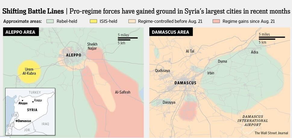
Al Tall
The city is rebel controlled per http://www.nytimes.com/2013/10/14/world/middleeast/in-syria-motorists-press-on-yielding-for-war.html?_r=0
Why was it reverted. and also qudsaya.Alhanuty (talk) 18:24, 2 February 2014 (UTC)
Al Tall and Qudsaya under control Syrian troops. This is shown on map in this source.The Wall Street Journal Hanibal911 (talk) 19:43, 2 February 2014 (UTC)
- You may want to repost it from a different address or something, says page no longer available. Sopher99 (talk) 19:44, 2 February 2014 (UTC)
Here's another link to the same source.The Wall Street Journal Hanibal911 (talk) 19:53, 2 February 2014 (UTC)
- That is a pay-to-view link, so not verifiable. Try another source. 174.93.178.123 (talk) 09:44, 6 February 2014 (UTC)
- If you cant view this source The Wall Street Journal here are a map from this source. Hanibal911 (talk) 10:07, 6 February 2014 (UTC)
Mayda'a (town on edge of Eastern Ghouta)
Can someone add the rebel held town of Mayda'a which is on the eastern edge of the rebel held Eastern Ghouta pocket? This would really help to define the size and parameters of this pocket. Most recent maps of Eastern Ghouta, such as the one on the Wikipedia Damascus Conflict page [10], this map which Hanibal911 posted a while ago [11], and this very interesting map posted on the Reddit Syrian Civil War page [12], identify it as rebel held and on the eastern front line. It should be posted as being under government siege, but I'm unsure of what size exactly the circle should be. This Wikimapia page [13] shows where it exactly is. Coordinates are lat=33.561 and long=36.525. Thanks, Hulahoop122 (talk) 04:40, 6 February 2014 (UTC)
- Done Hanibal911 (talk) 10:27, 6 February 2014 (UTC)
Nawa
Article used for the change is from September 2013 and it says that rebels lunched an offensive in Daraa it has been five months since then neither pro-opp nor government sources have said the town is rebel held.Second the town borders the 61 brigade and its housing is in the town and it has never been captured revert it to contested.Daki122 (talk) 20:17, 2 February 2014 (UTC)
From the Now lebanon source "The Syrian regime besieged Daraa’s Nawa and shelled it non-stop, which prompted a number of other battalions to intervene in order to free the city and open a supply line from Nawa to the Al-Yarmouk Valley,” he added." Sopher99 (talk) 20:30, 2 February 2014 (UTC)
Here is the date September 13, 2013 of the article what you are trying to play here.Daki122 (talk) 20:36, 2 February 2014 (UTC)
Omg i cant belive you just added government held towns in order to put Nawa as rebel held I mean come on man.But fankly I am not as stubborn as you and know of compromise so yea just undo all changes from the article as it is out of date.Daki122 (talk) 20:44, 2 February 2014 (UTC)
I agree that we need to undo all changes that have been made using this source. Hanibal911 (talk) 20:48, 2 February 2014 (UTC)
Never mind who did what just undo all the changes from the article.Daki122 (talk) 20:57, 2 February 2014 (UTC)
![]() Comment: Some users here seem to be mentally retarded, there's no other way to explain their non-sense changes. For that ones with a very, very low IQ, try to read and understand this if you can: I added a September 2013 source stating that Adwan & Al-Shaykh Saad towns were in Syrian Army control. Then, the notorious vandal & POV-pusher that everyone knows here, angried & frustrated with the rise of red dots, use the same source to put Nawa in lime, when there are newer sources on the contested status of that town (for example, this, from a month later). Understand that a source from October 2013, superseds an older one (September 2013), or I had to explain it too?. So, as there are not newer sources stating a change in the status of Adwan & Al-Shaykh Saad (as there is in the Nawa case), they will be added again in red. If you have a newer reliable source with a change in their status is OK, if not leave them as they are, period. Sorry for being so rude, but I cant stand no more with this stupidities and POV-pushing hypocrisies.--HCPUNXKID (talk) 16:13, 3 February 2014 (UTC)
Comment: Some users here seem to be mentally retarded, there's no other way to explain their non-sense changes. For that ones with a very, very low IQ, try to read and understand this if you can: I added a September 2013 source stating that Adwan & Al-Shaykh Saad towns were in Syrian Army control. Then, the notorious vandal & POV-pusher that everyone knows here, angried & frustrated with the rise of red dots, use the same source to put Nawa in lime, when there are newer sources on the contested status of that town (for example, this, from a month later). Understand that a source from October 2013, superseds an older one (September 2013), or I had to explain it too?. So, as there are not newer sources stating a change in the status of Adwan & Al-Shaykh Saad (as there is in the Nawa case), they will be added again in red. If you have a newer reliable source with a change in their status is OK, if not leave them as they are, period. Sorry for being so rude, but I cant stand no more with this stupidities and POV-pushing hypocrisies.--HCPUNXKID (talk) 16:13, 3 February 2014 (UTC)
- The problem is people posting to the map without first posting to the tables, so references are not readily available.
- Adding to that, many reliable sources are refused for ideological reasons (WP calls it POV pushing), in favour of distant sources which depend largely on other sources with contacts on the ground.
- Until we straighten out our methods, or Tradedia and Lothar are again more present, maintaining the map is bound to be chaotic.
- BTW, the rebels have held most (but not all) of Nawa since mid 2013. Similar to Jasim, which they recently took full control of.
- As it is, towns like Morek (northern Hama) were not recognized on our map as contested until the rebels took full control, despite being largely rebel controled for some months. But we were very quick to recognize regime control of Suran (further south), which we had as contested despite being fully rebel controled until the last few days. (The regime having a much greater offensive capacity than the rebels, can take control of an area more quickly.)
- Note that our symbols don't always reflect the reality. We mark towns as besieged (circle around), even if in a large pocket of control, with the threat coming from only one side. e.g. Morek = now threatened from the north, eastern Ghouta only from the perimetre. (It would be easy to define 4 (n,s,e,w) or 8 (adding ne, nw, se, sw) arcs to use in such cases.)
- - andre437 174.93.178.123 (talk) 11:52, 6 February 2014 (UTC)
Shaddadeh
I think city Shaddadeh cant be marked under control ISIS because in city also has representatives Jabhat al-Nusra.Ara News Hanibal911 (talk) 20:50, 2 February 2014 (UTC)
I personally visited Shaddadeh 2 months ago and I confirm this report. — Preceding unsigned comment added by 134.50.163.223 (talk) 10:56, 3 February 2014 (UTC)
I personally visited Shaddeh 2 days ago. I couldn't confirm that. — Preceding unsigned comment added by 158.58.237.203 (talk) 21:33, 3 February 2014 (UTC)
This also fits the other reports of there being an agreement between Nusra and ISIS for Hasakah province. Should we perhaps make all Hasakah rebel towns mixed control black and green? Kami888 (talk) 00:51, 4 February 2014 (UTC)
- As I understand it (correct me if I'm mistaken), Shaddadeh is partly ISIS controled, partly al-Nusra, with no conflict between the two, and neither side dominant. Maybe we should have split dots for these cases. What does everyone think ? - André437 174.93.178.123 (talk) 12:28, 6 February 2014 (UTC)
Morek
why is morek green???? put back to red — Preceding unsigned comment added by 46.161.92.126 (talk) 17:15, 4 February 2014 (UTC)
- Morek was captured by Jabhat al-Nusra.Al Jazeera Hanibal911 (talk) 09:57, 5 February 2014 (UTC)
- Not quite. Al-Nusra was only a small part, mostly FSA-associated rebels and the Islamic Front. They took the last regime checkpoints north of the town. (I don't have access to my computer for references at the moment.)
- Your source says that "rebel forces, including the Al-Nusra Front, had seized the town in fierce fighting overnight, cutting a strategic supply line for the regime that runs from Hama city north to two military bases in neighbouring Idlib province: Wadi Deif and Hamidiyeh". It claims SOHR as their source.
- However their conclusion that this cuts the regime supply line is false, since the rebels already controled the road south of Morek. It does however reinforce rebel control. It is a little south of Hamidiyeh. - André437 174.93.178.123 (talk) 12:28, 6 February 2014 (UTC)
Adra (township) & Adra Industrial City
Acc to Russia Today video report uploaded just a few mins ago both adras are bisieged by Syrian forces.-Rob2014 (talk)99.160.184.97 (talk) 12:56, 30 January 2014 (UTC)
We not use RT because it is not reliable source. Hanibal911 (talk) 13:07, 30 January 2014 (UTC)
- RT is generally considered to be a reliable, although biased, news source. Russia Today is biased toward the Syrian government. (Just as Voice of America, is reliable, but biased toward US allies.) Therefore, under the long-standing principle that biased sources can be used to document the opposing side's gains, then this should be used. Hulahoop122 (talk) 19:05, 30 January 2014 (UTC)
Adra is an industrial city and a source says about city of Adra. But industrial area which is located east of city is now under control Syrian army.The Independent Hanibal911 (talk) 13:16, 30 January 2014 (UTC)
- Hanibal, The Independent [14]has published a more recent and much more detailed article about the situation in Adra, and the article states that the town is under siege,; "I asked several officers why they did not counter-attack and retake Adra. They answered that there were thousands of civilians there whom the rebels were using as “human shields” and they denied an alternative explanation that they were short of soldiers. Even so, it was striking how few Syrian Army troops there were yesterday, either at the cement plant or in the front line, where there had been fighting around a bridge earlier in the week." The article does not however talk specially about the industrial area specifically. In the RT video the reporter explains that she was told that the soldiers do not attack, and just besiege, because they are afraid of harming civilians being held hostage, just as is described in The Independent article. Hulahoop122 (talk) 19:05, 30 January 2014 (UTC)
Nope the whole video talks about the residential area nothing mentioned about industrial area.And frankly the residential area is contested(not besieged because they split the two residential areas and are now fighting inside it)so I do not see anything to be changed on the map they are the same(As you can see on the video the are using roads around the factories to get to the residential area).Daki122 (talk) 14:27, 30 January 2014 (UTC)
Daki122 did you see video? look at 1:10, both adra city and adra ymalia (industrial area) are besieged, but under rebels control Hanibal911 if you believe independents words about adra, why dont you believe about malula? why dont you put malula in green? independents told that: "For instance, Jabhat al-Nusra has retaken the historic Christian town of Maloula"
what's wrong people with you? you believe  some words from "independents" and dont believe youre eyes ...
you are destroing all credibillity of this map ...
- The video very clearly says that both Adra and Adra Industrial city are being besieged by government forces. They even provide a nicely detailed map at 1:17 listing their names in both English and Arabic; Adra (Adra al Belyad) and Adra Industrial City (Adra Aumaliye) to explain this situation very specifically. They explain that they hold a slim the territory in between these two localities, and are trying to stop the forces in Adra and Adra Industrial City from linking up. She even conducts a tour of the front line. Hulahoop122 (talk) 19:05, 30 January 2014 (UTC)
Well as I said every day rebels said that they killed government forces in Maalula so stop crying about that.Second Adra Ymalia is part of the city of Adra not the Industrial zone.And third the border crossing in Qusayr is still contested even tough there is no evidence about that but do yo see me coming here and saying change that no you need credible evidence to support your claims which you have none.Daki122 (talk) 14:55, 30 January 2014 (UTC)
you are laier! look subtitres at 1:17 adra industriel city and adra aymaliye is same place! — Preceding unsigned comment added by Hellsurvivor (talk • contribs) 16:42, 30 January 2014 (UTC)
That's pro opposition and pro government sources for 21 December show that rebels were able to break through only to the city of Adra. While the industrial area was completely under the control of the army. Hanibal911 (talk) 17:18, 30 January 2014 (UTC)
- You are correct that those two maps from December show the industrial area controlled by the army. So either those maps were wrong (fog of war, rebels hidings, etc.), or the situation has changed during the last 40 days. Hulahoop122 (talk) 19:14, 30 January 2014 (UTC)
- Please refrain from expressing your POV here (per Wikipedia policy) André437, this is not a forum. Your statement was borderline inflammatory. As for the Arab Chronicle, if the change of territory on their map matches changes on pro-government maps than it will be accepted as a source of rebel gains, otherwise it will not be accepted because it is plainly obvious to anyone it is a highly biased pro-opposition source. EkoGraf (talk) 23:50, 31 January 2014 (UTC)
- Hulahoop122, the two Independent articles factually state the following. One, that the Army pushed out the rebels out of the industrial area. And two, that the most recent fighting has been concentrated in the residential area (which is independent from the industrial one). EkoGraf (talk) 23:54, 31 January 2014 (UTC)
- EkoGraf, yes what you point out is technically true, but I wonder if that one line in the first very broad Independent article is referring to a different industrial area, as there is more than one surrounding Adra (and apparently confusion about where the Industrial City is), or it just got it wrong. No matter what you think of Russia Today (reliable or biased), the RT on the ground video news report is dedicated just to the Adra conflict, and it is hard to argue that it would be so inaccurate about that. Regardless of the situation in Adra Industrial City, if no new fighting is reported in Adra, it should probably be listed as under siege rather than contested. Mixed control is another option, but I think under siege (from both the Independent and RT reports) is more accurate. Hulahoop122 (talk) 16:14, 1 February 2014 (UTC)
- Hulahoop122, the two Independent articles factually state the following. One, that the Army pushed out the rebels out of the industrial area. And two, that the most recent fighting has been concentrated in the residential area (which is independent from the industrial one). EkoGraf (talk) 23:54, 31 January 2014 (UTC)
Fierce clashes between the Syrian troops and the Free Syrian Army in cities of Darayya and Adra.Ara News. Hanibal911 (talk) 19:57, 1 February 2014 (UTC)
And if you look closely you will see that in city Adra also there is an Adra Industrial area. Perhaps it is about him mentioned in reportage on channel RT. Hanibal911 (talk) 20:17, 1 February 2014 (UTC)
- Doubtful, as the relative size and position of Adra and Adra Industrial City is the same on the RT map (at 1:17) as they are in the opposition and government maps you posted above. Nevertheless, if you and EkoGraf believe that this does not merit a change on the map, I am ok with moving on. Hulahoop122 (talk) 21:00, 1 February 2014 (UTC)
Since there is still confusion where is the actual position of Adra, I advise to navigate to the Adra region in Google maps, where I think its easier to see that the city is not fucking directly attached to Duma. OberschIesien90 (talk) 20:29, 3 February 2014 (UTC)
- OberschIesien90, on my talk page where we discussed this issue you indicated that you were willing to switch back the Adra/Adra Industrial City locations. Can you do that? Thanks, Hulahoop122 (talk) 03:50, 6 February 2014 (UTC) Nevermind. I was editing something else on the map, and just made that change. Cheers, Hulahoop122 (talk) 04:12, 6 February 2014 (UTC)
- I actually did it, and then you messed it up again with your last edit. Seriously, what is wrong with you people? You cannot deny geography, read a map. See also my comment above. OberschIesien90 (talk) 07:38, 6 February 2014 (UTC)
- Hmmmm. Oberschlesien90, we seem to somehow be speaking past each other. Maybe it would work better if we discuss what the map coordinates of Adra and the Adra Industrial City are. According to Wikimapia Adra is here [15] at latitude=33.604 and longitude 36.515. Do you agree with that? According to Wikimapia (and the other pro-opposition [16], and pro-government [17] maps Hanibal911 posted above), the Adra Industrial City is here [18] with latitude=33.615 and longitude 36.576. Do you agree with that? If you disagree, can you share your sources and coordinates? We can ask the other members to vote which coordinates they think are accurate. Thanks, Hulahoop122 (talk) 21:20, 6 February 2014 (UTC)
- I updated the position of Adra and the Adra Industrial City with those coordinates, which are a bit different from the coordinates that were previously used. If you have any issues with that, please discuss here. Hulahoop122 (talk) 00:21, 7 February 2014 (UTC)
- No problems with your edits. The issue was that you and others tried to move Adra to the west, to the eastern edge of Duma, where it is just not located. In this area between Duma, Adra prison, and Adra, there are some industrial areas, so we put an icon there called Adra industrial area to cover that region, because we assumed clashes there back in 2013. And then, to the east of Adra, we have the industrial city of Adra with the coordinates you submitted above. You get it? Two different icons called Adra industrial area, to the west and east of Adra. OberschIesien90 (talk) 18:02, 7 February 2014 (UTC)
- I actually did it, and then you messed it up again with your last edit. Seriously, what is wrong with you people? You cannot deny geography, read a map. See also my comment above. OberschIesien90 (talk) 07:38, 6 February 2014 (UTC)
Jaffra (Deir ez-Zor Province)
Village Jafra under control Syrian troops this confirms pro government Syrian TV and pro opposition SOHR sources. Hanibal911 (talk) 09:20, 25 January 2014 (UTC)
- Thats fine and all but if you click onto the deir ezzor map itself you will see jafra already there. Sopher99 (talk) 19:11, 25 January 2014 (UTC)
- But then need remove and village Hatla because this village also present on Deir ez-Zor map. Hanibal911 (talk) 19:40, 25 January 2014 (UTC)
Kafr zita
Kafr Zita change the color of kafr zita from black to green. since january 4 Kafr Zita has been under rebel control (mostly SRF, IF and JAN, various reliable sources like Cedric Labrousse and Aymenn al-Tamimi have confirmed this. videos from after january 4 clearly show an FSA banner group in the town https://twitter.com/ced_lab/status/419875011696926721 https://twitter.com/saleelalmajd1/status/419874040996962304/photo/1 https://www.youtube.com/watch?v=lzX-Ek2J1Ro https://www.youtube.com/watch?v=270vVIHvjGc
Arabthomness (talk) 19:58, 27 January 2014 (UTC)
- Though it's most likely true it would be nice to have a better source than twitter and youtube still. Kami888 (talk) 20:18, 27 January 2014 (UTC)
- We should accept it, since our initial evaluations were based on sketchy info and when the all-out war started between the rebels and the ISIS, many units were in the process of quitting the ISIS. Also note that this town in northern Hama is quite far from the nearest ISIS controled area. (No closer than northern Idlib at best). As well, here is a recent annotated map from the Arab Chronicle showing the town in rebel hands. Note that our map no longer shows Morek as contested (it did a few months ago), whereas this map shows that the rebels control most of the town. As well, Suran was taken by the rebels (and reported here) quite a while back, but it still shows as contested on our map. Since there are dated notes on this map beside the last 2 towns, these should be taken as reliable evidence of their current status.
- Note that sometimes the status of locations on our map has been changed (to regime held) because there were "no recent reports" of conflicts. But ongoing conflicts aren't news, so why would we necessarily expect recent reports ? There were no recent reports of conflicts in Babila and Beit Sham (adjacent areas), but the truce shows us that the rebels were still there. André437 (talk) 06:36, 28 January 2014 (UTC)