
Talk:Control of cities during the Syrian civil war/Archive 54
| This is an archive of past discussions about Control of cities during the Syrian civil war. Do not edit the contents of this page. If you wish to start a new discussion or revive an old one, please do so on the current talk page. |
| Archive 50 | ← | Archive 52 | Archive 53 | Archive 54 | Archive 55 | Archive 56 | → | Archive 60 |
Is anybody reading this page?
#Bir Khalah and other things to fix! I spent quite a lot of time looking for thinks to fix, but I can't change it myself since I don't have autoconfirmed status. So, can I have the status or someone else will do the changes? --Hogg 22 (talk) 06:56, 19 October 2015 (UTC)
- If you can't edit the article and would like to request an edit, you can use the {{edit semi-protected}} template. clpo13(talk) 09:36, 19 October 2015 (UTC)
- Done. Paolowalter (talk) 16:54, 19 October 2015 (UTC)
South of Aleppo
Many news are flowing in about south-west of Aleppo AlMasdar alMadar SOHR SOHR. Summarizing: Khan Thuma and Kalidya contested [1], they are on the ALeppo main page; Al-Huwayz taken by SAA. TellQuhra[ taken by SAA. [http://wikimapia.org/#lang=de&lat=36.120752&lon=37.092590&z=14&m=b Munition Storage & Army Base taken by SAA (I guess). Honestly the information are not always clear. Do you agree on these changes?Paolowalter (talk) 10:35, 19 October 2015 (UTC)
- I trust your judgement. Rhocagil (talk) 12:47, 19 October 2015 (UTC)
Syrian Army and Hezbollah Capture Tal SyriaTel in Southern Aleppo.http://www.almasdarnews.com/article/breaking-syrian-army-and-hezbollah-capture-tal-syriatel-in-southern-aleppo/ 46.200.207.127 (talk) 13:49, 19 October 2015 (UTC)
Tal Syria Tell is a strategic hill around 7 kilometers west of Al Hader, it is not shown on the map, a lot of places are not shown on the map, only places really insignificant in ISIS/FSA/AL Nusrat control get added, the Government towns get deleted by the many insurgent supporters on this article.SyrianObserver2015 (talk) 17:46, 19 October 2015 (UTC)
- It's near al waddihi, but you are right, strategic and not shown. There is actually a dispute where it is.Totholio (talk) 18:03, 19 October 2015 (UTC)
- There is a SyriaTel here but it seems in a area controlled by SAA since long time. I cannot find another close to the front line.Paolowalter (talk) 18:29, 19 October 2015 (UTC)
Mansoura
http://www.syriahr.com/en/2015/10/regime-forces-advances-in-al-ghab-valley/ — Preceding unsigned comment added by 2.87.204.184 (talk) 21:44, 19 October 2015 (UTC)
- SOHR claim that Mansoura Grain Silos under control of Regime forces. http://www.syriahr.com/en/2015/10/regime-forces-advances-in-al-ghab-valley/ 46.200.207.127 (talk) 05:21, 20 October 2015 (UTC)
East Aleppo
Isis confrims that they are still in controll of Muflisah,Dakwanah,Halabiyah here,also pro-regime source confirms this to here,Al-Masdar primary source is this guy Ibrahim Joudeh.46.99.68.133 (talk) 14:16, 19 October 2015 (UTC)
IS statement cannot be used in its favour. Maps cannot be use not even to support the opposite site. What is the point about Al Masdar? The latest info from AlMasdar states that Dakwanah is taken by SAA while Al-Mufliseh is still in IS hand with SAA on its outskirts. Halabiyah was taken some days before. SOHR speaks of clashes around al- Dekwani. Let's say that Dakwanah is on the front-line contested, Al-Mufliseh on the front line under IS control and Halabiyah most likely SAA control.Paolowalter (talk) 16:54, 19 October 2015 (UTC)
- No idea, this is why I highly doubt SOHR credibility(a lot of times masdar also) They got 0 source in IS/SAA, just guessing the casualties/progress.Totholio (talk) 18:04, 19 October 2015 (UTC)
Pro-rebels sources claim: Regime force controls village of Dakwanah and other villages nearby surroundings of Kweiris Airport and Thermal station after ISIS withdraw.https://twitter.com/abohafsalhamoe/status/656125309708804096 Assad's forces in control of villages Dakwanah and Baqisha less than 10 km from Kweiris military airport after the decline ISIS.https://twitter.com/Raman_Yusif/status/656166075122364416 https://twitter.com/saleelalmajd1/status/656139117164531712 46.200.207.127 (talk) 18:53, 19 October 2015 (UTC)
SAA launched a counter-assault from their positions at Burayjah in order to recapture western farms of Tal Sab’een and not only captured the western farms, but also captured hilltops overlooking of Tal Sab’een and forced ISIS to retreat further north. http://www.almasdarnews.com/article/cheetah-forces-press-further-in-east-aleppo-hilltops-overlooking-tal-sabeen-captured/ 46.200.207.127 (talk) 06:08, 20 October 2015 (UTC)
Kafr Dulbah and Tartiyah
Looks like i was in a cave for the last ten days. When did Kafr Dulbah moved from contested to red? the last info i can find online about it from RT (Pro-red)RT is That Kafr Dulbah is contested. (They stated the army is making progress in Kafr Dulbah which means they don't fully control it) if there is later news I can't find please inform me. Tartiyah on the other hand I heard no news of clashes overthere. waiting for answers Helmy1453 (talk) 17:00, 20 October 2015 (UTC)
Here is another Pro-red source (bousla states that RT claim advances in Kafr Dublah) just today stating advances for the SAA in Kafrdulbah and killing ,tens of terrorist bla bla bla. The point is if pre red states clashes and advances in the are how is it red already ??? If I get no reply by midday I will change it to contested Helmy1453 (talk) 17:19, 20 October 2015 (UTC)
If you have been absent, I am sorry for you but all changes were done following reliable sources. Therefore you are not going to change it unless new sources become available. The source you posted is in arabic, which I cannot read, and automatic translation ofetn confused 'inside' with 'around'. None of the usual sources posted any news such to require a change in the map. Tracking the sources that supported the changes can be a little time consuming but it is up to you if you want to check if they are good enough.Paolowalter (talk) 17:41, 20 October 2015 (UTC)
OK. fair enough. I will wait till a source in english states it, but many times I find sources in arabic with no equivelent in english. also those towns every one speels them his own way in englsih which make ssearch on google impossible where in arabic it is always spelled the same. But you will see that in a week or so we will here news from Kafr Dulbah that it is "captured" by the regime or clashes will hapen. let's wait and see. Helmy1453 (talk) 18:06, 20 October 2015 (UTC)
References to comments
Dear colleagues,
I propose to make it mandatory to put link to the source not [only] in the edit description, but also in comment after the changed line. As far as I understand, two dashes ( -- ) should work fine? Dr Bug (Vladimir V. Medeyko) 23:53, 20 October 2015 (UTC)
- I think the idea of putting comments after each line in the code might become tedious, but it is an interesting idea. I am all for making edit summaries and sources mandatory, as there is too much unsourced editing going on around here. 2601:C7:8303:22DC:1DB4:BFDC:1999:782E (talk) 02:44, 21 October 2015 (UTC)
Rasm Hater west of Al-Ithriyah
I´m adding the tiny village Rasm Hater (as under SAA control) just 2 km west of Al-Ithriyah, because I think it´s important to show as much information as possible around strategic places such as Al-Ithriyah. Of course I can´t be 100% sure about who is in control, but I think it´s a fair assumption that it´s government held. If anyone has an argument about this, please post your opinion. Rhocagil (talk) 20:55, 20 October 2015 (UTC)
- I would say it is probably government-held. Good edit. — Preceding unsigned comment added by 2601:C7:8303:22DC:1DB4:BFDC:1999:782E (talk) 02:48, 21 October 2015 (UTC)
Please add Al Jumaymah in S Aleppo
Please add Al Jumaymah in S Aleppo, based on Al-Masdar article. This pro-Assad news portal reports about rebels retreating from Balas to Al Jumaymah, which means the willage is definitively under rebel control. This area has too few villages on our map. --Hogg 22 (talk) 14:42, 20 October 2015 (UTC)
I did before I read your post. In anycase you can do it yourself.Paolowalter (talk) 17:41, 20 October 2015 (UTC)
- POST DELETED - Twitter is not a source, 46.200.207.127. Don't use it as one.DaJesuZ (talk) 23:22, 20 October 2015 (UTC)
- Undeleted, invalid sources shouldn't be used to edit, but shouldn't be deleted from the talk-page. There are few reasons to delete a comment on a talk page. In addition, twitter sources aren't necessarily bad, it's the person who makes the twitter post we should consider (here, Leithfadel). Banak (talk) 23:38, 20 October 2015 (UTC)
- POST DELETED - Twitter is not a source, 46.200.207.127. Don't use it as one.DaJesuZ (talk) 23:22, 20 October 2015 (UTC)
- Leith has been shown, on several occasions, regardless of his position as an editor for al-Masdar, to be biased and unreliable (based on his Twitter feed), going by it, without confirmation from al-Masdar, means there is a greater chance for inaccurate editing of the map. This guy's feed is not a source. Re-deleted. DaJesuZ (talk) 03:26, 21 October 2015 (UTC)
It is pretty obvious that Leith will post stuff on twitter before he has had it confirmed, not to mention some of his tweets are just intended as wind ups. With his pieces on al-Masdar he seems to be much more careful and while he might make the odd mistake there does seem to be a genuine attempt at accuracy. al-Masdar does report some rebel advances and recently as de-bunked some stories of more extravagant SAA advances. Therefore while I think it is right to use al-Masdar as a reliable source it would be a huge mistake to consider Leith's twitter account as reliable. Conservative Thinker (talk) 11:25, 21 October 2015 (UTC)
The Waha Report?
Hi! Is http://wahareport.com/ considered reliable source? --Hogg 22 (talk) 08:25, 21 October 2015 (UTC)
- We can monitor and see. As far as I could see, it reports news correctly but nothing different from other sources.
It should be understood if it has sources on ground or if it just copies news from other sources.Paolowalter (talk) 09:03, 21 October 2015 (UTC)
- I'm asking because today's report says "Opposition and SAA forces clash in Bayt Awan, north of Latakia. Reports of casualties on both sides.", and Bayt Awan is red on our map. I will be bold and change it :). Feel free to revert it if You disagree. --Hogg 22 (talk) 13:44, 21 October 2015 (UTC)
Whole of Al Zahara district captured by The Syrian Arab Army, Goverment forces
| Sockpuppet |
|---|
| The following discussion has been closed. Please do not modify it. |
|
Al Zahara captured by the legitimate Government Armed forces of the sovergn state of Syria: [2] http://www.almasdarnews.com/article/syrian-army-overpowers-jabhat-al-nusra-in-west-aleppo-entire-al-zahra-quarter-captured/ SyrianObserver2016 (talk) 13:21, 21 October 2015 (UTC)
I am sure that they mean what they mean and not what you think they mean. I am sure when they state "Whole of Al Zahara captured by the Syrian Arab Army" that is what they mean, not what you think they mean. SyrianObserver2016 (talk) 15:14, 21 October 2015 (UTC) Oh come on SyrianObserver2016, quit being such a propaganda-hothead. Jesus Christ ... "legitimate government armed forces of the sovergn (grammar mistake, mind you) state of Syria". Don't let my laugh. I read the article. For one, it's from Al Masdar. They claimed weeks ago that "rebels" didn't even enter Al-Zahra district during their offensive. Now, the rebels are pushed out? Strange, since, according to Al Masdar, they were never inside in the first place. Find some decent sources. — Preceding unsigned comment added by 84.24.43.183 (talk) 16:33, 21 October 2015 (UTC) |
Keep an eye on Mansour and it's grain south of it
I've seen pictures I trust of rebels taking control of grain south of Mansoura. these sources are Pro-Rebels and don't meet this page criteria so I am not posting them or updating anything, just saying keep aware if any reliable(per this page) sources anounce it. P.S looks like SOHR is in a coma lately they rarely report anything at all. all our updates lately are per Al-Masdar if this continues for long time we will need to find another Pro-Rebel reliable source other than SOHR, but that is a discusion for another day. Helmy1453 (talk) 17:45, 21 October 2015 (UTC)
Jabbul
Isis has retaken Jabbul 8 days ago and pro-regime source Al-Masdar didn't report that,but other pro-regime sources did.PetoLucem,here.46.99.17.6 (talk) 09:45, 21 October 2015 (UTC)
I saw the news but it is not available on what we condider reliable sources but only on map and twitter. Let keep an eye when and if it will be reported through reliable sources.Paolowalter (talk) 10:33, 21 October 2015 (UTC)
SAA probably withdraw for tactical reasons or something as we have heard nothing from either SOHR or Al-Masdar. Otherwise I think it´s very strange that two of the most pro-regime sources makes their maps without showing SAA presence in Jabbul. Rhocagil (talk) 11:07, 21 October 2015 (UTC)
SAA captured village of Tal Sabin south of Kuwairis Airport.source Also pro rebels source confirmed that Jabbul under control of SAA. https://twitter.com/Abboud11S/status/656581621840220160 46.200.207.127 (talk) 12:30, 21 October 2015 (UTC)
- Paolowalter which is that reliable source that we should wait to report this that didn't report it 1 week ago ? Al-Masdar?? that is reporting that the syrian army are only 1 village close to the airport or that of pro-rebels source who some are saying they captured Jabbul some say they recaptured Bashiqah!?.Tell me please.46.99.72.61 (talk) 16:02, 21 October 2015 (UTC)
- I cannot understand your question. Opinions on Jabbul differ even between pro-government outlets. It is reported that SAA pulled out without fighting (and therefore went unreported) to defend Tell Naam. We can also put it contested (in any case is next to the front line).Paolowalter (talk) 16:30, 21 October 2015 (UTC)
- Another advance toward the base http://www.almasdarnews.com/article/breaking-cheetah-forces-enters-sheikh-ahmad-4km-left-to-lift-the-siege-of-kuweires-airport/.Paolowalter (talk) 16:30, 21 October 2015 (UTC)
Somewhat pro OPP Agathocle deSyracuse has Jabbul contested on his (today 21 oct) map. Thou I have no idea how credible his maps are. Anyway it might be logical as Paolowalter says to put it contested.Rhocagil (talk) 17:47, 21 October 2015 (UTC)
Sheikh Ahmad et al.
Dear colleagues,
don't you think that it would be right to add towns of
- Settlement name in latin script (population 2004, coordinates) date captured by SAA [references] (Settlement name in arabic script)
- Al-Nasiriyah (?, 36°6'30"N 37°28'20"E) 16.10 [3] (الناصرية)
- Al-Huwayjinah (1112, 36°6'40"N 37°26'35"E) 17.10.2015 [4] (حويجينة)
- Burayjah (1448, 36°7'17"N 37°28'59"E) 18.10.2015 [5] (بريجة)
- Dakwanah (688, 36°8'14"N 37°29'23"E) 18.10.2015 [6][7] (دكوانة)
- Tal Sab'in (890, 36°7'11"N 37°30'29"E) 20.10.2015 [8][9][10] (تلة الصبيحية) (AKA تل سبعين)
- Sheikh Ahmad (697, 36°9'4"N 37°31'46"E) 21.10.2015 [11] (شيخ احمد)
- Al-Halabiyah (1858, 36°8'22"N 37°28'0"E) 22.10.2015 [12] (الحلبية)
that were taken by the asadists on the respective dates according to Al-Masdar News? Yes, I undersand, that most of these are small towns and villages, but without them this part of the map look unreasonably empty and doesn't reflect the real situstion. (2004 population data according to [13]). Tal Na'am, for example, was put on the map, despite it's of no more importance that listed above. Dr Bug (Vladimir V. Medeyko) 17:31, 22 October 2015 (UTC)
There is nothing like 'asadists', it is called SAA, army or government foces. Those locations are located in the are covered by the detailed Aleppo map. There is a red dot on the map which I cannot understand what it is referring to. Tal Na'am is just outside the border of the map and was given its own point. The changes you require should be addressed to the Aleppo detailed page.Paolowalter (talk)
Semi-protected edit request on 21 October 2015
This edit request to Module:Syrian Civil War detailed map has been answered. Set the |answered= or |ans= parameter to no to reactivate your request. |
Change "Hawsh Haju" to contested per reliable source: http://www.syriahr.com/en/2015/10/is-mobilize-its-soldiers-in-the-eastern-countryside-of-hama-and-ongoing-clashes-in-the-northern-countryside/
This source reported that the Islamist rebels and the government were clashing violently around Hawsh Haju near Homs. I think we should do a contested icon for that town, but a green siege icon would also do the job. " 2601:C7:8303:22DC:290C:A330:6FCA:AE4D (talk) 21:18, 21 October 2015 (UTC)
We cant marked Hawsh Haju as contested because SOHR only said that clashes near this town between Islamist rebels and Syrian troops. 46.200.207.127 (talk) 06:11, 22 October 2015 (UTC)
- Where is this place?Paolowalter (talk) 07:38, 22 October 2015 (UTC)
- http://wikimapia.org/#lang=en&lat=35.268608&lon=37.376175&z=12&m=b&show=/4560831/As-Si-in&search=Aleppo — Preceding unsigned comment added by MesmerMe (talk • contribs) 08:11, 22 October 2015 (UTC)
- That's As Si'in. Hawsh Haju is near Homs: wikimapia. --Hogg 22 (talk) 12:16, 22 October 2015 (UTC)
- http://wikimapia.org/#lang=en&lat=35.268608&lon=37.376175&z=12&m=b&show=/4560831/As-Si-in&search=Aleppo — Preceding unsigned comment added by MesmerMe (talk • contribs) 08:11, 22 October 2015 (UTC)
Will someone please make the edit?2601:C7:8303:22DC:862:D47F:F030:9061 (talk) 23:07, 22 October 2015 (UTC)
SAA advance to South of Aleppo
SAA advanced and captured three villages to south of Aleppo(Sufayrah,Al-Qarassi and Al-Huwayz) village Balas contested.source 46.200.207.127 (talk) 11:51, 21 October 2015 (UTC)
Pro FSA source reported that the vilages Khan Touman and Balas under control by rebels and that Tal Al Mahruqat,Al Waddihi,Kadar,Tank Battalion,Al Sabaqiyah,Abtin,Tel Shaheed,Mount Azzan,Al Malahiya, Rasm Bakru under control of SAA.https://pbs.twimg.com/media/CRzAFStUYAAXgTZ.png:large 46.200.207.127 (talk) 13:18, 21 October 2015 (UTC)
Clashes between SAA and opposition forces in al-Eis http://wikimapia.org/#lang=en&lat=36.000924&lon=37.052078&z=13&show=/21654766/Al-Eis-%28Qinnasrin%29&search=Al-Hadher and al-Hadher http://wikimapia.org/#lang=en&lat=35.995508&lon=37.024441&z=13&show=/1696731/Al-Hadher&search=Al-Hadher, southwest of Aleppo. http://wahareport.com/2015/10/20/syria-daily-report-20102015/ 46.200.207.127 (talk) 18:33, 21 October 2015 (UTC)
SAA entered the imperative town of Sheikh Ahmad on the fringes of the Kuweires Military Airbase after intense firefights with ISIS.http://www.almasdarnews.com/article/breaking-cheetah-forces-enters-sheikh-ahmad-4km-left-to-lift-the-siege-of-kuweires-airport/ 46.200.207.127 (talk) 18:39, 21 October 2015 (UTC)
SAA captured villages of Tal Maflass http://wikimapia.org/#lang=en&lat=36.004257&lon=37.237988&z=13&m=b&show=/object/history/list/?object_type=1&id=33938090&lng=en ,Al-Ayoubi(including its surrounding farms) http://wikimapia.org/#lang=en&lat=36.004257&lon=37.237988&z=13&m=b&show=/object/history/list/?object_type=1&id=33938090&lng=en and Air Defense Battalion Base.http://www.almasdarnews.com/article/syrian-army-and-hezbollah-make-massive-gains-in-southern-aleppo-rebel-defenses-collapse/ 37.53.191.209 (talk) 16:29, 22 October 2015 (UTC)
SAA advance in southern countryside of Aleppo and captured Ghayghar, Al-Ajoubiyah Farms, Tal Mafless, Balas, and Jawar Al-Jahish after fierce clashes with Liwaa Suqour Al-Sham and Harakat Nour Al-Deen Al-Zinki. SAA also advance deep into the town of Kafr ‘Abid, which is located directly south of Balas and directly east of Kafr ‘Abish. So Kafr Abit still contested.http://www.almasdarnews.com/article/hezbollah-and-the-syrian-army-capture-several-sites-in-southern-aleppo-dagestani-emir-killed/ 37.52.24.103 (talk) 06:37, 23 October 2015 (UTC)
East Hama
Does anybody know where al-Sa’en al-Aswad is SOHR? Paolowalter (talk) 20:40, 21 October 2015 (UTC)
- Al-Nusra and Jund Al-Aqsa launched a powerful assault on strategic town al-Sa’en in Hama Governorate but resulting in a series of intense firefights between the aforementioned Islamist group and NDF throughout the day they was unable to break-through the frontline defenses of Syrian troops and were forced to retreat to north in order to evade both the Syrian and Russian Air Forces that were lurking around the Hama-Idlib border.http://www.almasdarnews.com/article/important-battle-brewing-in-northern-hama-jabhat-al-nusra-attacks-al-siin/ 46.200.207.127 (talk) 06:09, 22 October 2015 (UTC)
I read the news. I just asked wher eis the town.Paolowalter (talk) 07:38, 22 October 2015 (UTC)
- Made the edit as an arch in the north, per ALMSDR news reporting the attack at the outskirts and a retreat north-ward.Ariskar (talk) 08:53, 22 October 2015 (UTC)
Paolowalter I don´t give much for this map but it points out the village you requested.Rhocagil (talk) 13:55, 23 October 2015 (UTC)
Al-Masdar map of N Homs
Check this map by Al-Masdar. Some of the rebel-held areas on Al-Masdar map are marked red on our map. It this just sloppy journalism or we can rely on this? --Hogg 22 (talk) 07:35, 23 October 2015 (UTC)
There is consensus on not using maps. I saw some discrepancies but they are not large, al-Halamuz seems the largest difference.Paolowalter (talk) 15:06, 23 October 2015 (UTC)
Rebels E and SE of al-Hamraa (NE of Hama)
I think we have some wrong data on the map. Please find city of al-Hamraa, NE of Hama, on Hama-Idlib border. All willages S and SE of al-Hamraa are red, but some pro-SAA sites are reporting rebel attacks in that area.
For example:
- syria 24 english: SAA Destroy TWO (2) Militant tanks EAST of Hamra
- Al-Masdar: [rebels] launched several attacks on the SAA’s positions along the Hama-Idlib border, targeting the Syrian Government controlled towns of Sukayk, ‘Abdel-‘Aziz, Al-Hamra, and Qal’at Rahiya on Friday morning. I believe ‘Abdel-‘Aziz and Qal’at Rahiya are willages Tall `Abd al `Aziz and Ruhayyah SE of al-Hamraa, see wikimapia. We have those willages on the map as Ruhayyah and Tall Abdelaziz.
Does anyone has more info on this area? --Hogg 22 (talk) 09:31, 23 October 2015 (UTC)
- I do not understand which changes you requires. The map is essentially correct Paolowalter (talk) 15:06, 23 October 2015 (UTC)
- And here it is: Iranian (pro-SAA) farsnews.com reports of airstrikews on rebel-held Tawal al-Dabaghin, which I found on wikimapia, just east of Al-Hamraa! I'm adding it to the map. --Hogg 22 (talk) 12:35, 23 October 2015 (UTC)
Syrian Arab Army, legitimate Government Forces capture more towns in Aleppo.
| Sockpuppet |
|---|
| The following discussion has been closed. Please do not modify it. |
|
Source for captured towns: [14] Sana: "Army units, in cooperation with the popular defense groups, established control over al-Huweiz and al-Qarasi villages in the southwestern countryside of Aleppo province, a military source announced." — Preceding unsigned comment added by SyrianObserver2016 (talk • contribs) 13:49, 23 October 2015 (UTC) Already turned red some days ago.Paolowalter (talk) 15:06, 23 October 2015 (UTC) |
Aleppo maps
There are two maps of Aleppo, but the first primary one does not show the so called- ammunition storage base as a goverment held territory while the other does. Both are created by MrPenguin20. In addition, the Rif-Aleppo map, Maryamayn is indicated as rebel-held and KafrAbid contested, showing rebel advatage. Is it true ? What do we know about the infarntry school ? Pro-gov. sources don't mention it's under SAA control. Oroszka (talk) 15:26, 23 October 2015 (UTC)
- As far as we know, the infantry academy is still under Islamic State control, so the map looks a little off in that area. Regime forces haven't been mentioned to've entered the academy, but have been in its vicinity, and to the east of it for days. DaJesuZ (talk) 19:23, 23 October 2015 (UTC)
SAA advance in Latakia province
SAA capture of Kataf Al-Ghaddar and have advanced inside the strategic city of Salma, capturing several building blocks and hilltops from the Islamist rebels, while also minimizing their losses at this volatile front. http://www.almasdarnews.com/article/syrian-army-special-forces-sweep-through-the-hills-surrounding-the-strategic-city-of-salma/ 91.124.122.78 (talk) 11:32, 24 October 2015 (UTC)
Aleppo supply road cut
Here is a twitter post from a very reputable source (a page run by numerous well-known mapmakers) https://twitter.com/IUCAnalysts/status/657547319181709312
Here is a post from an IS source (assuming it's IS at least) displaying that they defeated an attempted Government counterattack. https://twitter.com/maghrebiwtis/status/657649089300049920
Here is an article from a source of unknown bias outlining the situation. I am not an Arabic reader by the way, so someone would have to translate for me. https://a3maqagency.wordpress.com/2015/10/23/%D8%A7%D9%86%D9%81%D9%88%D8%AC%D8%B1%D8%A7%D9%81%D9%8A%D9%83-%D9%82%D8%B7%D8%B9-%D8%B7%D8%B1%D9%8A%D9%82-%D8%A5%D9%85%D8%AF%D8%A7%D8%AF%D8%A7%D8%AA-%D8%A7%D9%84%D9%86%D8%B8%D8%A7%D9%85-%D8%A7%D9%84/ — Preceding unsigned comment added by 76.126.188.171 (talk) 05:23, 24 October 2015 (UTC)
- The Syrian regime is suffering from a manpower shortage, so an advance by both the rebels and Islamic State like this is very possible (however, this is simply my point of view, and POV edits are not allowed), but that would mean we have several town and cities marked incorrectly. The Arabic source you provided states that the Islamic State has severed the Syrian government's supply lines to Aleppo. I have no idea if this is true, but keep an eye out for more stories about it. This would be a massive development, and would influence the battle for Aleppo city, massively. DaJesuZ (talk) 08:37, 24 October 2015 (UTC)
Firstly this pro ISIS source https://a3maqagency.wordpress.com/2015/10/23/%D8%A7%D9%86%D9%81%D9%88%D8%AC%D8%B1%D8%A7%D9%81%D9%8A%D9%83-%D9%82%D8%B7%D8%B9-%D8%B7%D8%B1%D9%8A%D9%82-%D8%A5%D9%85%D8%AF%D8%A7%D8%AF%D8%A7%D8%AA-%D8%A7%D9%84%D9%86%D8%B8%D8%A7%D9%85-%D8%A7%D9%84/ And more reliable source reported that the Syrian Army Reopens the Ithriyah-Salamiyah Road in East Hama After Defeating ISIS. http://www.almasdarnews.com/article/breaking-syrian-army-reopens-the-ithriyah-salamiyah-road-in-east-hama-after-defeating-isis/ 91.124.122.78 (talk) 11:30, 24 October 2015 (UTC)
- This very source clearly states that IS holds parts of the Aleppo-Khanasser Hghway: "While the Syrian Armed Forces were successful in the aforementioned military endeavor, the Syrian Government’s main supply route along the Aleppo-Khanasser Highway that leads to the Aleppo Governorate remains cutoff by ISIS; this report has been confirmed by multiple sources from the Syrian Arab Army and National Defense Forces in the Hama Governorate. As long as ISIS has control of the Ithriyah-Khanasser Road, the Syrian Armed Forces will not have direct access to the imperative Aleppo-Khanasser that leads to the Aleppo Governorate’s provincial capital." 84.138.74.98 (talk) 12:38, 24 October 2015 (UTC)
User: Sakultah
User Sakultah is on a source-less editing rampage. More then ten non sourced edits the last week (did not ever give a sourced edit). Latest Ex; 1, 2, 3, 4, 5. Can somebody that knows how block this editor. Rhocagil (talk) 16:30, 24 October 2015 (UTC)
Sources for Idlib changes
I've seen some changes in the past few days. I have some questions about them:
- Which source was used to make the town of Al Taman'ah (east of Khan Shaykun, Idlib) contested between the FSA and Jabhat al-Nusra?
- Which source was used to make Tell Al-Teri red? — Preceding unsigned comment added by 84.24.43.183 (talk) 15:59, 24 October 2015 (UTC)
There was heavy fighting between the moderates in Taman'ah and today jund al aqsa left jaish al fateh cause they are too moderate for them. More moderate infighting soon.Totholio (talk 16:42, 24 October 2015 (UTC)
Source please? Your not giving one, just talking. I can claim "the SAA retook Idlib city when they landed on the back of a Divine Budha Elephant". Doesn't make it true. Also, Al Taman'ah was contested BEFORE Jund al-Aqsa left Jaysh al-Fatah, so your argument is invalid.
Aleppo changes
Rebels have retaken the villages of Al-Qarassi and Ayyubid yesterday and today. Those two villages are shown as SAA held on this map. We should change them to green. Source: http://www.petercliffordonline.com/syria-iraq-news-5/
The road between Khanassir and Aleppo has been cut by Islamic State fighters. Fighting is ongoing, but the sources are clear: the road is closed. We should make the red dots for the supply road black. Source: http://uk.reuters.com/article/2015/10/24/uk-mideast-crisis-syria-aleppo-idUKKCN0SI08U20151024 Source: http://www.muscatdaily.com/Archive/Gcc/Syria-army-battles-to-retake-Aleppo-supply-line-from-IS-4dn6 Source: http://www.reuters.com/article/2015/10/23/us-mideast-crisis-syria-idUSKCN0SH2D520151023 — Preceding unsigned comment added by 84.31.204.195 (talk) 12:42, 24 October 2015 (UTC)
This source too biased pro rebel source.http://www.petercliffordonline.com/syria-iraq-news-5/ Also Syrian Army Reopens the Ithriyah-Salamiyah Road in East Hama After Defeating ISIS.http://www.almasdarnews.com/article/breaking-syrian-army-reopens-the-ithriyah-salamiyah-road-in-east-hama-after-defeating-isis/ http://isis.trendolizer.com/2015/10/breaking-syrian-army-reopens-the-ithriyah-salamiyah-road-in-east-hama-after-defeating-isis.html 91.124.122.78 (talk) 15:09, 24 October 2015 (UTC)
Only Islamic State members, speaking to Reuters via internet from inside Syria, said their group had taken control of the road southeast of Aleppo. But SOHR only reported about fierce fighting between Syrian government forces and Islamic State in area of this road.http://www.reuters.com/article/2015/10/24/us-mideast-crisis-syria-aleppo-idUSKCN0SI08N20151024 So we not confirmations from reliable sources that ISIS captured some part of this road. The road was closed due to the clashes but not under the control of ISIS. But reliable source clear said that the Syrian Army Reopens the Ithriyah-Salamiyah Road in East Hama After Defeating ISIS.http://www.almasdarnews.com/article/breaking-syrian-army-reopens-the-ithriyah-salamiyah-road-in-east-hama-after-defeating-isis/ 91.124.122.78 (talk) 15:22, 24 October 2015 (UTC)
Alright, so this means that we can't use Al-Masdar as a source when "members of the Syrian Army claim to have taken a town"? Because we used some of those articles last week to make changes in Hama governorate? If your line of reasoning is solid, we can only use direct statements from sources on the ground in the area.
- IS took TWO sections of the highway near Ithriyah. One section between Ithriyah and Salamniyah and one section between Ithriyah and Khanaser. The Al-Masdar article clearly states that SAA retook only the section between Ithriyah and Salamniyah but that IS still controls parts of the highways between Ithriyah and Khanaser! 84.138.74.98 (talk) 16:25, 24 October 2015 (UTC)
Assad's forces control Tel Ambassador from the nearby village of Jabboul after another against ISIS. https://twitter.com/24Aleppo/status/657958483917197313 91.124.122.78 (talk) 16:56, 24 October 2015 (UTC)
- Tweets are not a reliable source. 84.138.74.98 (talk) 16:59, 24 October 2015 (UTC)
SOHR claim that the clashes continue between regime force and IS on Khenaser-Ethria road in the southern eastern countryside amid advances for the regime in the area.http://www.syriahr.com/en/2015/10/human-losses-and-continued-clashes-in-aleppo/ So SAA advance against ISIS in this area. 91.124.122.78 (talk) 17:59, 24 October 2015 (UTC)
- The article does not state that SAA took full control of the area, so it should not be changed to red (yet), as clashes are still ongoing. 84.138.74.98 (talk) 18:26, 24 October 2015 (UTC)
But also for now we cant marked this road on black color. So for now I think we just need remowed this icon. For now we only know that SAA advance in this area. 91.124.122.78 (talk) 18:59, 24 October 2015 (UTC)
- Al-Masdar News (as well all know is very pro-Government) mentions that only the portion between Salmaniyah and Ithriyah has been reopened. The portion between Ithriyah and Khanisir is still held by IS. The article even states that. http://www.almasdarnews.com/article/breaking-syrian-army-reopens-the-ithriyah-salamiyah-road-in-east-hama-after-defeating-isis/ — Preceding unsigned comment added by 76.126.188.171 (talk) 20:37, 24 October 2015 (UTC)
- According to all reliable sources, the highway is still blocked by IS; though SAA may make progress, SAA does not have full control of the highway which is the SAA's vital supply route to the whole Aleppo region. This should be reflected by the map, and some IS presence should be shown between Ithriyah and Khanassir. 84.138.74.98 (talk) 20:52, 24 October 2015 (UTC)
Southe Aleppo
From http://www.almasdarnews.com/article/4th-mechanized-division-and-hezbollah-capture-over-45km-of-territory-in-southern-aleppo/ I'd say Al-Hamraa with a green ring on the west/south side, Kafr-Abid contested (as is), Shugaydilah contested. Any objections?Paolowalter (talk) 08:27, 25 October 2015 (UTC)
On a different note, Al-Masdar states that the road Ithriyah - Khanasser still is blocked by IS: [15]. 84.138.74.98 (talk) 10:30, 25 October 2015 (UTC)
- The Telegraph also states that IS seized the highway [16]. Until we have a reliable source stating that SAA took back FULL CONTROL of the highway, we should indicate some IS presence between Ithriyah and Khanassir. 84.138.74.98 (talk) 10:46, 25 October 2015 (UTC)
Rural icon in south Aleppo deleted
Why was the rural icon, used to represent the Islamic State taking control of portions of the Hama-Aleppo highway? All sources, including al-Masdar, have stated that IS holds at least a small section of the highway. I do not know the exact coordinates of the icon, so I'm relying on someone else to place it again.DaJesuZ (talk) 13:05, 25 October 2015 (UTC)
Markabah still under SAA
SOHR confirmed that the village Markabah in Hama still under control by Syrian troops.http://www.syriahr.com/en/2015/10/russian-airstrikes-on-hama-countryside-and-clashes-in-homs-countryside/ and other source announce that 23 October that the rebels(Regiment.111 & the 6th brigade) captured village Markabah, seized a tank and withdrew due to airstrikes.https://twitter.com/BosnjoBoy/status/657621744769966081 Saphyr99 (talk) 17:09, 25 October 2015 (UTC)
Eastern Aleppo IS offensive
Al-Masdar [17] states that IS took Tall Riman [18] and Salihiyah [19] before moving in the direction of Tel Aran [20] and Aziziyah [21], without taking the latter two. Non-reliable sources also reported clashes between SAA and IS at Tal Hasel [22] and the cable factory [23]. 84.138.74.98 (talk) 05:46, 25 October 2015 (UTC)
Non-reliable sources should not be quoted at all. They cannot be used, more often than not false and just increase confusion.Paolowalter (talk) 08:24, 25 October 2015 (UTC)
- Alright. SOHR confirms [24] clashes between SAA and IS near al-Sfirah [25], Tal Aran [26] and Tal Hasel [27]. The article does not state change in ground control though. 84.138.74.98 (talk) 10:58, 25 October 2015 (UTC)
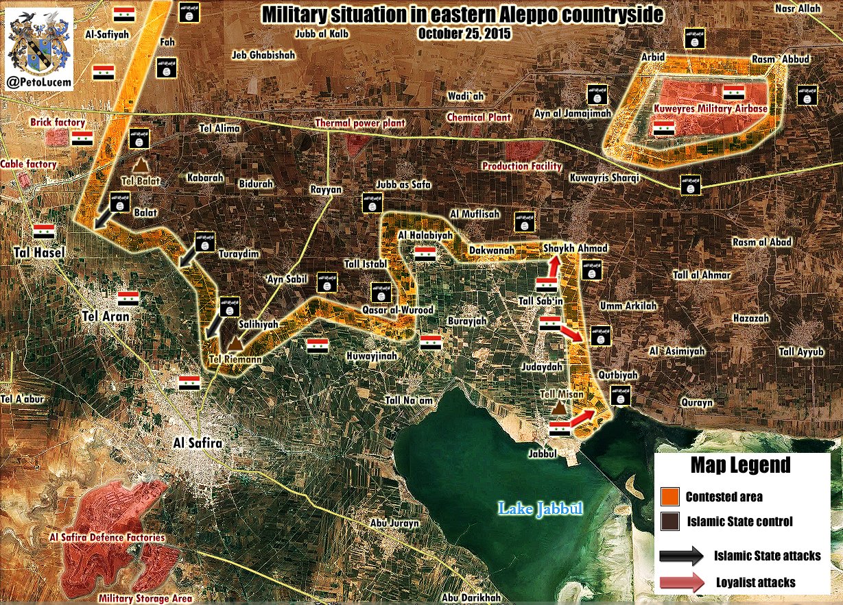
Pro SAA source https://pbs.twimg.com/media/CSKq0qGUEAAmmZ7.jpg:large https://twitter.com/PetoLucem/status/658278280513081344 and Pro ISIS source http://img15.hostingpics.net/pics/871561aleppoe20151025M.jpg showed that al-Sfirah [28], Tal Aran [29] and Tal Hasel [30] under control SAA and that clashes still far away from these cities. But both of these sources confirmed that ISIS retake Saligiyah and Tell Riemann to north of Al Safira Saphyr99 (talk) 18:00, 25 October 2015 (UTC)
- These are not reliable sources. 84.138.74.98 (talk) 20:42, 25 October 2015 (UTC)
SOURCES AGAIN (FOR THE 1000TH TIME)
- Mansoura (Ghab plain) changed to red without a legitimate source (so no Twitter, YouTube, rumors)
- Al-Taman'ah (Idlib) changed to contested between FSA and Al-Nusra, no sources given
- Khalasah (Aleppo) changed to contested without a legitimate source
- Mahija (Daraa) changed back to red, without a source mentioned here
When will this stop? You are completely destroying this map. Twitter maps are more accurate these days than Wikipedia is. It's a shame! — Preceding unsigned comment added by 84.24.43.183 (talk) 14:21, 26 October 2015 (UTC)
- Khalasah - was marked as under SAA but I marked as under FSA because SOHR said that The Russian warplanes carried out several airstrikes on places in Khan Toman area, the town of al- Hader and the village of Khalsah in the southern countryside of Aleppo, coincided with shelling by the regime forces on the village of Dadin in the southern countryside of Aleppo.http://www.syriahr.com/en/2015/10/at-least-14-ndf-militiamen-killed-in-an-explosion-on-al-ramosah-road-and-the-regime-forces-retake-the-cement-plant/ village Al-Hamreaa near Khalasah marked as contested.
- Mansoura under SAA - http://www.almasdarnews.com/article/syrian-army-captures-al-mansoura-inside-the-al-ghaab-plains/
- Mahija (Daraa) - was marked under FSA also without sources.
- Al-Taman'ah (Idlib) - changed to contested between FSA and Al-Nusra according to SOHR. And also (pro FSA) news source SyriaLiveNetwork also reported 20 October about clashes between Ahrar Al-Sham and Jund Al-Aqsa in Al-Tamanah town.here 46.200.206.144 (talk) 19:44, 26 October 2015 (UTC)
Road to Aleppo
There is a consensus on this page that the road from Aleppo to Hama has been cut off by the Islamic State. All sources on this page state that the road was cut off by the Islamic State, and some even state that the rebels from Idlib attacked the road. Al-Masdar DOES state that they cleared the road in one area, but at least one section of the road remains cut of by IS.
Someone on this page is deleting my marker, showing there being an IS presence there (I used the rural icon, as roads are not shown on the map, so I can't use a point to show control over a road, because of those being used for cities), and replacing it with a marker showing regime forces having fully opened the road, which they haven't, as shown by all sources have shown that IS fighters still hold at least part of the road.
I'll be copying the line for the marker I made, and putting it back in the edit page, should it be deleted, and deleting the army icon on the road to aleppo, should it be put back. DaJesuZ (talk) 06:02, 26 October 2015 (UTC)
The dots showing rural icons have a ill defined meaning. Nevertheless the road is at a large extent under SAA control with only some sections taken by IS. No reason to put black dots and removing red ones. The best solution is to remove dots alltoghether waiting that the situation stabilizes.Paolowalter (talk) 09:04, 26 October 2015 (UTC)
syrianewsapp. which is pro red states that SAA and its allies withdrawn from points between Ithrea and zakeya chackpoint. problem is I don't know where the hell is zakiah checkpoint ? does anyone knows where it can be ? Helmy1453 (talk) 19:08, 26 October 2015 (UTC)
- Could it be this here? [31] Reportedly, IS took it today. 84.138.74.98 (talk) 22:35, 26 October 2015 (UTC)
Al-Masdar states [32] that IS today (26th) occupied the highway between Salamiyah and Ithriyah near Sheikh Helal [33]; however, the article also states that SAA was able to unblock the highway at Sheikh Helal afterwards. Furthermore, the article states that Ihtriyah-Khanassir is still blocked and that Al-Bashiri Farms, Ithriyah Checkpoint and the Majabel Checkpoint near the town of Ithriyah are under IS control and that SAA "targets" these places. I cannot locate any of the three places. 84.138.74.98 (talk) 00:45, 27 October 2015 (UTC)
Source clear said that the SAA recapture Al-Bashiri Farms, Ithriyah Checkpoint, and Majabel Checkpoint near the town of Ithriyah and reopen the Ithriyah-Sabourah Road.http://www.almasdarnews.com/article/syrian-army-attempts-to-reopen-strategic-highway-cutoff-by-isis/ SOHR also reported about clashes between SAA against IS around al-Shekh Hilal in Salamia countryside and that the SAA re-gain control in few areas.http://www.syriahr.com/en/2015/10/clashes-between-is-and-regime-forces-in-salamia-countryside/ 46.200.206.144 (talk) 05:39, 27 October 2015 (UTC)
- The source does NOT state that the SAA recapture Al-Bashiri Farms, Ithriyah Checkpoint, and Majabel Checkpoint near the town of Ithriyah! "The Syrian Armed Forces have started their large-scale counter-assault in east Hama; however, there have been no reported gains yet (other than the recapture of the Ithriyah-Sabourah Road), as they target the Al-Bashiri Farms, Ithriyah Checkpoint, and the Majabel Checkpoint near the town of Ithriyah." So the three places are under IS and SAA only "targets" them. 84.138.74.98 (talk) 09:50, 27 October 2015 (UTC)
- Source clear said that SAA recapture of the Ithriyah-Sabourah Road as they target the Al-Bashiri Farms, Ithriyah Checkpoint, and the Majabel Checkpoint near the town of Ithriyah. So course mantion that after SAA retake Al-Bashiri Farms, Ithriyah Checkpoint, and Majabel Checkpoint near the town of Ithriyah they reopen of the Ithriyah-Sabourah Road. But source not said that this objects under ISIS. 46.200.206.144 (talk) 11:41, 27 October 2015 (UTC)
- Your second sentence makes no sense. The source does NOT mention or imply, that SAA opened the road AFTER it retook the three places. It only states that SAA opened Ithriyah-Sabourah Road. It does also not state that the three places are directly on the road Ithriyah-Sabourah, so opening the road does not imply that SAA took the three places. Also the source states that SAA "targets" the three places. Why would SAA target them, if SAA had control of them? Of course SAA targets them since some one else (IS) is there! 131.188.48.174 (talk) 12:38, 27 October 2015 (UTC)
- Source clear said that SAA recapture of the Ithriyah-Sabourah Road as they target the Al-Bashiri Farms, Ithriyah Checkpoint, and the Majabel Checkpoint near the town of Ithriyah. So course mantion that after SAA retake Al-Bashiri Farms, Ithriyah Checkpoint, and Majabel Checkpoint near the town of Ithriyah they reopen of the Ithriyah-Sabourah Road. But source not said that this objects under ISIS. 46.200.206.144 (talk) 11:41, 27 October 2015 (UTC)
Fafin / Infantry School area?
Is there any source, that the SAA has taken the Infantry School or that Fafin (north of Aleppo) is disputed? I was waiting now for long, thinking, that the red icons would be reverted to black. As I remember there was only some rumors that the SAA was fighting in Fafin, this was some weeks ago, but then they were repulsed. Same question for the area north of the Juvenile Prison (which I suppose is really in the hand of SAA), but this is the place most in the north with the SAA, because the cement factory (north of it) is with ISIS.Mughira1395 (talk) 10:24, 27 October 2015 (UTC)
- (pro FSA source) SAA take Juvenile Prison near Aleppo after ISIS retreat. https://www.facebook.com/LCCSy/posts/1243486995678434 (reliable source) http://www.almasdarnews.com/article/isis-in-danger-at-the-strategic-aleppo-infantry-academy-syrian-army-advances-north/
- (pro FSA source) ISIS have surrendered Cement plant near Aleppo to regime forces. http://qasioun.net/en/article/Syrian-regime-hits-the-opposition-sites-in-Aleppo-countryside-using-Poisoned-gases/3777/
- (Pro FSA source) Regime forces now controls the Infantry School,after ISIS seized it from Rebel forces. https://twitter.com/Abboud11S/status/653952289426788353 (pro FSA source) Aleppo Infantry School under control Assad troops. https://www.zamanalwsl.net/news/64946.html#.Vh1IKUrJQvQ.facebook
- Fafin - contested. http://www.almasdarnews.com/article/isis-in-danger-at-the-strategic-aleppo-infantry-academy-syrian-army-advances-north/ 46.200.206.144 (talk) 11:37, 27 October 2015 (UTC)
I turned Fafin black because it was contested only briefly with no other mention of fighting since a while. Infantry School was already debated in the past, pro-FSA sources were not reliable (twitter). All other sources and map agree it is under IS control, so it has to stay black.Paolowalter (talk) 15:08, 27 October 2015 (UTC)
Thanks - your first and your last source is the same. Do you really think that this tweet is to be taken serious?? But let us take Masdar: What you brought was from 13th of October and there was no mention about Infantry School taken by SAA (nor your other source Qasioun), instead it mentioned that the Infantry School was taken by ISIS on 11th. This was also written on 12th, here: http://www.almasdarnews.com/article/syrian-army-captures-kafr-tunah-and-jabal-antar-from-isis-in-northeast-aleppo/ and here: http://www.almasdarnews.com/article/syrian-army-makes-huge-gains-in-northern-aleppo-isis-loses-more-territory/
Now let us see what cames from Masdar the following days: On 14th very obvious, that Infantry School was not taken by SAA, but is still with ISIS, and also Fafeen is reported in hand of ISIS and not mentioned with the gains of SAA: http://www.almasdarnews.com/article/complete-battle-map-of-syria-mid-october-update/ and also: http://www.almasdarnews.com/article/isis-continues-advance-into-aleppo-city-islamist-rebels-retreat-from-two-towns/
On 15th ISIS is still at Infantry School: http://www.almasdarnews.com/article/islamist-rebels-recapture-tal-jibeen-from-isis-while-the-syrian-army-targets-the-aleppo-infantry-academy/
And it is unlikely that Masdar will not report such an advance of the SAA. And this also shows the "quality" of the tweet of 13th...
So, as I see from the sources the Infantry School must be with ISIS / put black and the same for Fafeen (as there were no more combat reports since 11th, when the SAA came only to the eastern perimeter of the town - see your Masdar-source, and afterwards, see also Masdar-source of 15th, it was reported with ISIS.Mughira1395 (talk) 15:13, 27 October 2015 (UTC)
Unclear situation in Aleppo
The rebels claimed to have captured al-Hamra: SOHR, but it is red on this map. What is the actual situation? The situation in Kafr Abid is similar. Al-Masdar said it was captured by the army on the 22nd, but it turned out to be contested. Both sides of the conflict provide very inconsistent news regarding the situation. I urge editors to confirm their sources more carefully. Deserttanker (talk) 21:35, 25 October 2015 (UTC)
The new from the rebels on their own conquest are worthless. They lie all the time. SOHR is quite reliable but the its statement is quite vague "information reported ...". Of course al-Hamra is on the front line and the situation there has to be monitored continuously. Same thing for Kafr Abid situation is fluid and the front line is close or within the town. Paolowalter (talk) 09:04, 26 October 2015 (UTC)
- Al-Masdar states [34] that '[..] Islamist rebel forces captured the Aleppo Cement Factory [35], Al-Halisah Farms [36], and a number of hilltops near the strategic city of Khan Touman [37] [..]'. 131.188.48.174 (talk) 15:20, 27 October 2015 (UTC)
- Also, SOHR reports "clashes around the village of Tyarah" [38] here [39] and "in al- Sheikh Hlal area" [40] here [41], though there is no claim about change in territory control. 131.188.48.174 (talk) 15:31, 27 October 2015 (UTC)
Talbiseh (Homs)
SOHR claim that clashes continue in Talbisa between regime forces and Islamic battalions what devastated 2 tanks for regime forces.http://www.syriahr.com/en/2015/10/continued-clashes-in-homs-countryside/ 91.124.122.78 (talk) 18:04, 24 October 2015 (UTC)
Too poor evidences need something more or these places will be keeping on red. --LogFTW (talk) 10:51, 28 October 2015 (UTC)
Video near Ithriya
Can someone geolocate this? --Hogg 22 (talk) 19:22, 27 October 2015 (UTC)
- This video from the pro-ISIS source and there is no reliable confirmations when and where this video was filmed. 37.52.25.132 (talk) 20:30, 27 October 2015 (UTC)
The video is not a reliable source, but it was filmed here [42] (notice the tower in the video, it is "Burj at-Taghtiyah"). 84.138.74.98 (talk) 21:03, 27 October 2015 (UTC)
This reporter says that IS captured this "army base checkpoint"and he also says that government forces recaptured at least 4 which makes him realible. I actually don't have to say this because we are using him as a source for at least a year for all (government, rebel, Kurd, ISIS) changes. The checkpoint should be added on the map as the area is already somehow marked as under ISIS control on the colour map. — Preceding unsigned comment added by 109.175.83.43 (talk) 23:12, 27 October 2015 (UTC)
- This article says "ISIS is now in control of 19 checkpoints belonging to the pro-regime forces and allied militias in Aleppo suburbs, as the entire district of Ithreya fell to the radical group." So Al-Ithriyah on the map should now be black? Esn (talk) 03:59, 28 October 2015 (UTC)
- Consider how reliable other sources are, I believe a video is more then enough. Regarding "water pump" under IS control (source is given by Esn), there are several wells in the area, all on to the east of Ithriya, just like the captured checkpoint. I don't think Ithriya sahould be black, but black semicircle to the east seams appropriate.--Hogg 22 (talk) 07:38, 28 October 2015 (UTC)
Firstly ARA News biased anti-SAA source and another source clear said that the with help from Russian Air Force the Syrian troops clear the Raqqa-Salamiyah Highway that is perpendicular to the Khanasser-Ithriyah Highway after intense clashes with ISIS and that the Khanasser-Ithriyah Highway is still closed due to ISIS’ presence at the checkpoints located north of Ithriyah; however, Syrian Army and pro-government militia “Liwaa Al-Quds” are working to recapture these sites from ISIS. http://www.almasdarnews.com/article/russian-air-force-restarts-aerial-campaign-in-east-hama-to-help-the-syrian-army-defeat-isis/ 37.52.25.132 (talk) 08:40, 28 October 2015 (UTC)
Please let's try to stick to reliable sources for making changes even at the cost of waiting a few more days. Private videos (not from professional sources) are banned. Remember that there is no independent sources in those areas and basically all reports are biased. We can retain Ithriya with a black semicircle for a while to signal IS activities around the town waiting for additional news. Paolowalter (talk) 10:13, 28 October 2015 (UTC)
- Come on, Paolowalter, any video is reliable, unless You trying to say that it's been edited? Checkpoint is easily identified in video and it's completely irrelevant who made the video. The only legitimate question is whether information is too old, since things can change quickly. But to discard evidence because video author is "biased" is nonsense. --Hogg 22 (talk) 11:24, 28 October 2015 (UTC)
- Hogg 22 this video here was taken from pro ISIS source and video showed ISIS fighters on some distance from Burj at-Taghtiyah but not inside of him. Also we can't know when this video was filmed week or months ago or maybe in past year. So all amateur video from YouTube or from biased sources can't be a reliable sources. 37.52.25.132 (talk) 11:41, 28 October 2015 (UTC)
- Hogg 22 But here source said that ISIS controlled willage of Tabaret al-Sakhaneh between Khanaser and Ithriya. 37.52.25.132 (talk) 11:45, 28 October 2015 (UTC)
- Correct, the video cannot be used as a source on its own, but the reporter BosnoSinj, a reliable source, confirmed [43] that IS took Burj at-Taghtiyah. 131.188.48.174 (talk) 11:55, 28 October 2015 (UTC)
- Hogg 22 But here source said that ISIS controlled willage of Tabaret al-Sakhaneh between Khanaser and Ithriya. 37.52.25.132 (talk) 11:45, 28 October 2015 (UTC)
- Hogg 22 this video here was taken from pro ISIS source and video showed ISIS fighters on some distance from Burj at-Taghtiyah but not inside of him. Also we can't know when this video was filmed week or months ago or maybe in past year. So all amateur video from YouTube or from biased sources can't be a reliable sources. 37.52.25.132 (talk) 11:41, 28 October 2015 (UTC)
- Cool, now we will wait for some reliable source like BosnoSinj to view the video, make logical conclusion that this is Burj at-Taghtiyah CP, without *any* other knowledge about the situation, post it on twitter and only then we will find it appropriate to add a black dot. That sounds logical. Not. --Hogg 22 (talk) 12:06, 28 October 2015 (UTC)
- ?? As I said, the tweet is a proper source. The video is not, it only substantiates BosnoSinj's claim. Anyway, Burj at-Taghtiyah CP should be added to the map as black. 131.188.48.174 (talk) 13:48, 28 October 2015 (UTC)
- I added it, but it was reverted. --Hogg 22 (talk) 14:26, 28 October 2015 (UTC)
- ?? As I said, the tweet is a proper source. The video is not, it only substantiates BosnoSinj's claim. Anyway, Burj at-Taghtiyah CP should be added to the map as black. 131.188.48.174 (talk) 13:48, 28 October 2015 (UTC)
- Hogg 22 I think mb this source can help,also about the Khanaser and Ithriya highway a pro-goverment source talks about airstrikes hitting Isis position,Near Tel-Mregan where in the map shows the Isis icon presence.I think we should add it??46.99.24.56 (talk) 15:55, 28 October 2015 (UTC)
ISIS near Jisr al-Shughour?
According to the CBC: "We stop in a place just south of Jisr al-Shughour. It's the last Syrian army post. Two rusting tanks and a pick-up lie behind this frontline, along with uniformed men, still fighting to win this war.
On the surrounding hilltops just 300 metres away, invisible to the naked eye, are ISIS fighters."
Is this a mistake, or is the presence of ISIS in Idlib province claimed anywhere else? Esn (talk) 18:23, 28 October 2015 (UTC)
Actually yes RT wrote about it a couple of days ago. I thought it was strange, probably an editorial mess-up. I still think it is, but i does raise question.
- “Su-25 attack jets have destroyed three fortified points of Islamic State terrorists near the village of Salma in the province of Latakia,” Konashenkov said. “The sites were equipped with bunkers, pillboxes and mortar positions.”
Rhocagil (talk) 19:14, 28 October 2015 (UTC)
- I feel like if the Islamic State had fighters in Idlib, and especially Latakia, al-Masdar or SOHR would report about it, and so far, neither of them have. al-Masdar and RT have reported of, "islamists," being there, but that usually means that they're referring to the Islamic Front, or it's constituent groups, or al-Nusra. This does deserve some attention, though, since IS was driven from Idlib more than a year ago. Is it possible they're referring to extremely northern Hama, the CBC article, I mean? Right now, the government doesn't hold any ground in Idlib near Jisr al-Shughour.DaJesuZ (talk) 19:59, 28 October 2015 (UTC)
This is pure propaganda shit, Russian, Iranina, Lebaneese and Chinesse (mainly all Assad supporters) like to call anyone fighting SAA ISIS just for the fun of it. but it is pure Bogas. Helmy1453 (talk) 20:23, 28 October 2015 (UTC)
IS 10 km west(!) of Palmyra
Can someone help me find the location of "al-Baiyarat area 10 kilometers west of Palmyra city". According to pro-SAA sana.sy, IS has some fortified positions there. Our map has only red marks in that area. --Hogg 22 (talk) 09:43, 28 October 2015 (UTC)
P.S. The same pro-SAA source mentions IS-controlled willage of "Tabaret al-Sakhaneh" between Khanaser and Ithriya, which could be a nice addition to the map. --Hogg 22 (talk) 09:52, 28 October 2015 (UTC)
- Tabbaret es-Sakane [44] should be added to the map as a black dot, according to SANA-source [45]: "Other ISIS positions were targeted by army air strikes in Tabaret al-Sakhaneh village along Khanaser-Atherya axis." 131.188.48.174 (talk) 11:47, 28 October 2015 (UTC)
- Hogg 22 this is location of al-Baiyarat 10 kilometers west of Palmyra city.46.99.28.184 (talk) 11:58, 28 October 2015 (UTC)
- Thanks for Your effort, but I was hoping to see some object on the map with that name, not just line that measures 10 miles (not km :). --Hogg 22 (talk) 12:03, 28 October 2015 (UTC)
- Hogg 22 Mb I measured wrong sorry, but thats the al-Baiyarat area.Al-Maqsam,Al-Qadahat,Abu al Fawaris.Tarafah,Ad Daw,Turayfawi,Bir um Tabair,Al-Qulaybah,Al-Qarmad(Al-Qadri Farms),Al-Bayda.This what it called Al-Baiyarat area but i see the map is not correct there to much mistakes where it shows the besiege icon on Palmyra it looks like the syrian army are near which is not in fact I just saw a Isis video showing military exercise in Palmyra.It's impossible to do military drills and fight an opponent at the same time.46.99.28.184 (talk) 12:33, 28 October 2015 (UTC)
- Great, thanks for the info! So, basically, "al-Baiyarat" is propably name for all this fertile area W of Palmyra? I see a lot of argicultural land there. Do You have some local knowledge of the area or just from the internet? Regarding siege symbol, that's because of SAA on SyriaTel hill. --Hogg 22 (talk) 12:53, 28 October 2015 (UTC)
- Hogg 22 Mb I measured wrong sorry, but thats the al-Baiyarat area.Al-Maqsam,Al-Qadahat,Abu al Fawaris.Tarafah,Ad Daw,Turayfawi,Bir um Tabair,Al-Qulaybah,Al-Qarmad(Al-Qadri Farms),Al-Bayda.This what it called Al-Baiyarat area but i see the map is not correct there to much mistakes where it shows the besiege icon on Palmyra it looks like the syrian army are near which is not in fact I just saw a Isis video showing military exercise in Palmyra.It's impossible to do military drills and fight an opponent at the same time.46.99.28.184 (talk) 12:33, 28 October 2015 (UTC)
- Hogg 22 I have been reading and searching a lot of sources and maps not just from internet but from books too.And for the al-Baiyarat area to confrim my argument here a pro-goverment source which talks about it but the matter here is that this pro-goverment source claims that the army is 5 km from Qassoun Mountain and this doesn't confrim that they captured Syria Tall Tel beacause how can you capture the Tel when you are 5 km from the Qassoun Mountain which is located there?? and the other problem is that the other pro-goverment " Sana" source claims that that the army hit Isis forces in Baiyarat area 10 km west of Palmyra which Al-Masdar denies that and claims that the army is 5 km near Palmyra and Isis has no forces there ,this are 2 contradictory statements.46.99.17.248 (talk) 13:22, 28 October 2015 (UTC)
- Hogg 22 I also found these villages in Hama that Sana was talking about:Tanahij,Jbab,Amun,Shaykh Hilāl,Rasm at Tinah.46.99.17.248 (talk) 13:41, 28 October 2015 (UTC)
Sheikh Hilal and Raqqa-Ithiriyah highway under SAA. Source said that the in conjunction with their success along the Raqqa-Salamiyah Highway, the SAA and NDF pushed south of Sheikh Hilal village in order to buffer-zone to the south of the aforementioned highway.sourcesource 37.52.25.132 (talk) 13:58, 28 October 2015 (UTC)
- Also many mistakes make when translated articles from SANA from Arabic to English. So it is likely in the original article stated that SAAF carried out sorties against gatherings and dens of ISIS in areas of the villages of al-Sheikh Hilal, Rasm al-Tineh, Rasm Amoun, Jbab and Tanahej in the eastern countryside of Hama province. 37.52.25.132 (talk) 14:05, 28 October 2015 (UTC)
- Assuming that the translation is incorrect and guessing some arbitrary "correct" translation is original research. Also the Al-Masdar article does not even mention the Raqqa-Ithiriyah highway, it is only reporting success on Raqqa-Salamiyah highway which consists of two parts, Raqqa-Ithiriyah and Ithiriyah-Salamiyah. The article does not specify, which part it is referring to, however, the mentioned village Sheikh Hilal is on the Ithiriyah-Salamiyah part, making it more likely, that the article refers to the Ithiriyah-Salamiyah part of the Raqqa-Salamiyah highway. 131.188.48.174 (talk) 14:12, 28 October 2015 (UTC)
- You are right source later said that SAA and their allies recapture of Ithriya-Salamiyah road that was obstructed by ISIS for several hours before pro-government forces were able to reclaim lost points. In addition to their success along Ithriyah-Salamiyah Road, SAA were able to recapture points lost to ISIS on roads leading to towns of Al-Sa’an, and Sheikh Hilal; this gave pro-government forces breathing room as they prepared for massive assault on Khanasser-Ithriya Highway. SAA began their assault on ISIS’ positions along Khanasser-Ithriya Highway after Russian Air Force conducted several airstrikes in order to weaken ISIS defenses.http://www.almasdarnews.com/article/syrian-army-attempts-to-reverse-isis-gains-along-the-highway-to-aleppo/ 37.52.27.29 (talk) 07:44, 29 October 2015 (UTC)
- Assuming that the translation is incorrect and guessing some arbitrary "correct" translation is original research. Also the Al-Masdar article does not even mention the Raqqa-Ithiriyah highway, it is only reporting success on Raqqa-Salamiyah highway which consists of two parts, Raqqa-Ithiriyah and Ithiriyah-Salamiyah. The article does not specify, which part it is referring to, however, the mentioned village Sheikh Hilal is on the Ithiriyah-Salamiyah part, making it more likely, that the article refers to the Ithiriyah-Salamiyah part of the Raqqa-Salamiyah highway. 131.188.48.174 (talk) 14:12, 28 October 2015 (UTC)
Back to the subject. Not only that IS is 10 km west of Palmyra, but there is not a single SAA solder within 10 km of Palmyra in any direction, as admitted by Al-Masdar. In article "Syrian Army Eyes the Ancient City of Palmyra: Ground Operations to Begin Soon", it clearly says:
- Unfortunately, the Syrian Armed Forces have since lost the hilltop at Tal Syriatel, the Palmyra Diving School, and the eastern groves of Al-Bayarat; this leaves them about 10km away from the Qassoun Mountains that overlook Palmyra’s west district.
So, I'm painting to black anything within 10 km of Qassoun Mountains. --Hogg 22 (talk) 08:03, 29 October 2015 (UTC)
Contradicting claims for Mansoura
Yesterday, Al-Masdar [46] stated that Mansoura was taken by SAA. Today, SOHR [47] states that Syrian Arab Air Force bombs "[..] places in the villages of Tal Waset, al- Mansoura, al- Qahera, al- Hamidiyya as well as the town of al- Zyarah in Sahl al- Ghab [..]". I guess, we should mark Mansoura as contested until the situation clarifies. 131.188.48.174 (talk) 15:05, 28 October 2015 (UTC) i agree and I did mentioned that before on 21st of October. Helmy1453 (talk) 17:14, 28 October 2015 (UTC)
- Do you realize how crap SOHR translation to english is? They could easily mean the silos. Why you open new topic for mansoura every day? Totholio (talk) 19:05, 28 October 2015 (UTC)
- Totholio, Mansoura is an important town in the al-Ghab plains area, and has been viciously fought for by the opposition and regime forces; bringing things up about Mansoura can't be faulted, if there is evidence that one of the two sources we label as, "reliable," is incorrect, or outright lying. The silos, as reported on this pager, were taken by the government days ago. Mansoura should be marked as contested, if the government is bombing the town.DaJesuZ (talk) 19:28, 28 October 2015 (UTC)
- Yes I know, definitely contested. Masdar claimed SAA controls southern part of the town.Totholio (talk) 11:57, 29 October 2015 (UTC)
Al-Masdar lies again
I stated in 21st of october that Almansoura and it's grains are green, we never changed them as SOHR and Al-Masdar didn't mention it. Now Almasdar in 26th of October here states that SAA captured Al-Mansoura ??? how can they capture it if it was in thier hand from the first place ? under all circomstances tht proofs that from 21st of october till 26th our map was showing wrong color for Al-Masoura . and maybe till today. and these happens all the time. We need to solve this we can't just use Al-Masdar for SAA and it's alies gains that is just wrong Helmy1453 (talk) 19:23, 27 October 2015 (UTC)
- First of all you got 0 credibility being a nusra supporter, every normal person knows in a war the situation changes every day. Specially on a front like this. Masdar claimed on 26 that the city was captured, they had control before on the silos you .... Totholio (talk) 19:02, 28 October 2015 (UTC)
Something else, this complete article by Al-Masdar is made up because they are claiming something while the same group which Al Masdar mentiones claims exactly the opposite. — Preceding unsigned comment added by 109.175.83.43 (talk) 23:09, 27 October 2015 (UTC)
- Right, because no Islamist terror group has EVER gone back on what it said before, right? XJ-0461 v2 (talk) 15:37, 28 October 2015 (UTC)
- Totholio, I'm an IS supporter in this war (in the short term; I do NOT want these people turning the area into an actual caliphate), someone supporting a particular side does not immediately ruin that person's credibility. Credibility i determined by how objective/accurate his reports and edits are, no matter who they are in support of. I haven't made too many edits, but they've mostly been in support of the Islamic State. I don't have no credibility because of that. DaJesuZ (talk) 14:11, 29 October 2015 (UTC)
Palmyra changes ??
Is their a source for the making of Tall Syria Tell black and the other areas west of Palmyra that the SAA have had captured less than a month ago seems unrealistic that IS took all these areas west of Palmyra and no one mentions it in talk page or even posts a source? Unrealistic because their is a massive force of SAA west of Palmyra all the ways up to Tall Syria Tell I see no sourced edit for these massive changes probably user Duckzz or Dajesus map manipulating again?? This latest post talks about the SAA around the close vicinity of Palmyra city so these changes look like copying a map I strongly recommend reverting them to as they were 3 days ago! http://www.almasdarnews.com/article/syrian-army-restarts-palmyra-operations-with-the-help-of-russian-airstrikes/ — Preceding unsigned comment added by 95.83.250.22 (talk) 10:44, 30 October 2015 (UTC)
- What do you mean? It is discussed in detail on the talk page: https://en.wikipedia.org/wiki/Talk:Cities_and_towns_during_the_Syrian_Civil_War#IS_10_km_west.28.21.29_of_Palmyra. 131.188.48.174 (talk) 17:56, 30 October 2015 (UTC)
Khan Touman
SAA/Hezbollah Advance to Khan Touman and capture farms Qarassi Farms located between strategic towns of Khan Touman and Qarass in southern Aleppo.http://www.almasdarnews.com/article/breaking-syrian-army-and-hezbollah-advance-to-khan-touman-in-southern-aleppo/ https://twitter.com/Amin_Akh/status/660109667734061057 91.124.122.249 (talk) 15:48, 30 October 2015 (UTC)
While initial reports stated SAA and their allies were in full control of Khan Touman, a military source from the SAA 4th Division confirmed that city was not captured; however, he added that SAA and their allies have entered Khan Touman and imposed control over 50% of area, leaving on the Army Storage Facility left under rebels control.http://www.almasdarnews.com/article/syrian-army-and-hezbollah-enter-strategic-city-in-southern-aleppo/ 91.124.122.249 (talk) 06:20, 31 October 2015 (UTC)
Kafr Dulbah
SOHR: Violent clashes took place between SAA against rebels and Islamist factions around Kafr Dulbah in northern countryside of Lattakia, amid advancement for rebels and seizing areas being controlled by SAA, certain information reported that rebels could seize village of Kafr Dulbah.http://www.syriahr.com/en/2015/10/the-rebel-factions-advance-in-the-northern-countryside-of-lattakia/
- Pro SAA sources denied this information and reported that village of Kafr Dulbah still under SAA.https://www.facebook.com/The.True.Tube/posts/931054166942324 https://www.facebook.com/Somar.Hatem.News/posts/655917151178543 https://www.facebook.com/Eyadalhosainmainpage/posts/1647620432144606 91.124.122.249 (talk) 13:01, 30 October 2015 (UTC)
Facebook posts are not a credible source. — Preceding unsigned comment added by 95.83.250.22 (talk) 13:12, 30 October 2015 (UTC)
- SOHR said might control it. ARounf Kafr Dulbah . when SOHR says they did control part of Kafr Dulbah let me know and I will make it contested. untill otherwise Kafr Dulbah stays red. Helmy1453 (talk) 14:07, 30 October 2015 (UTC)
- On another note that actually indicates that Tartiah which is to the north of Kafr Dulbah is not contested anyway. I guess Tartiah should go green per as concluded from above source. any Ideas about that ? Helmy1453 (talk) 14:14, 30 October 2015 (UTC)
- SOHR said might control it. ARounf Kafr Dulbah . when SOHR says they did control part of Kafr Dulbah let me know and I will make it contested. untill otherwise Kafr Dulbah stays red. Helmy1453 (talk) 14:07, 30 October 2015 (UTC)
SOHR states [48] very clearly: "[..] amid advancement for the rebels and seizing areas being controlled by the regime forces, certain information reported that the rebels could seize the village of Kafar Dalbah [..]". So, Kafr Dulbah to green. 131.188.48.174 (talk) 18:19, 30 October 2015 (UTC)
- "could seize the village of Kafar Dalbah," doesn't mean, "have seized the village of Kafar Dalbah." The village is staying red until actual confirmation the opposition has taken the town.DaJesuZ (talk) 20:29, 30 October 2015 (UTC)
- "could", past tense of "can", as in: "were able to". What does the arabic version of the article say? 84.138.74.98 (talk) 20:42, 30 October 2015 (UTC)
- You're equating, "were able to," to, "did take control of," which just doesn't work. That article states that they may have been able to, at some point, take control of the town, but does not state that the rebels seized the opportunity and did so. The article states that the rebels advanced, and that the town was within their reach, but does not state that the rebels even made it into the town, let alone take control of it. The town will stay red until someone provides something stating the opposition holds the town.DaJesuZ (talk) 06:55, 31 October 2015 (UTC)
Homs
Al-Masdar and Al-Masdar2 states that the east parts of Jawalek and Sinaysil have been taken by SAA. Goven that SAA ia attacking from west and that it was already present in the small town, it should mean that it took control of them and should go red. At least that is my understanding. What do you think? Paolowalter (talk) 22:40, 30 October 2015 (UTC)
- If this and this are correct, Jawalek and Sinaysil should be conteste. It simply states that regime forces are in the towns, and are fighting for them, seizing ground within the last couple days, but that they do not control the towns, entirely. DaJesuZ (talk) 07:00, 31 October 2015 (UTC)
Initiative to mark main roads, highways on the map
Main battles in Syria are for control of supply roads. If roads, highways where marked on the map it would help to better understand the conflict. --Bozocv (talk) 19:02, 31 October 2015 (UTC)
SAA advance to South of Aleppo
Syrian Army and Hezbollah Capture Jamaymah,Maryameen,Hadidah(Hamidah) and Zahra’a in Southern Aleppo and rebels complete withdrawal to the strategic town of Al-Hadher.sourcesource 46.201.163.140 (talk) 18:37, 31 October 2015 (UTC)
I guess, from maps from various authors that also Subayhiyah is taken by SAA. It is supported by the statement 'rebels complete withdrawal to the strategic town of Al-Hadher'. If there is no objection I can add it red.Paolowalter (talk) 19:18, 31 October 2015 (UTC)
Brigade 82 near Sheikh Maskin
Hi,
There are several videos of rebels near Brigade 82 (Sheikh Maskin). Can someone who speaks arabic check if this base is really rebel-held? --Hogg 22 (talk) 08:59, 31 October 2015 (UTC)
The videos are old. There are no American/Saudi/Turkish backed mercenaries near this area. — Preceding unsigned comment added by 95.83.250.142 (talk) 12:22, 31 October 2015 (UTC)
Recenyly SAA went close to the base, but I have not seen any news of government forces recapturing it.Paolowalter (talk) 23:09, 31 October 2015 (UTC)
Damascus east ghouta
Apparently Hawash al-Dumal http://wikimapia.org/#lang=it&lat=33.474695&lon=36.463451&z=15&m=b has been taken by SAA Al-Masdar. The detailed map of Damascus should be updatedPaolowalter (talk) 22:01, 30 October 2015 (UTC)
The detailed Damascus map has been vandalized (last change) close to Harasta by the usual vandal; that should be reverted. Ther ehave been some progress on the rebel side but not as large as shown. In the last weeks there have been some advances on government side but it is difficult to find clear statements on where the front line is on the Harasta Highway area.Paolowalter (talk) 22:38, 30 October 2015 (UTC)
- Is Hosh al-Dumal really the same as Hosh Al-‘Admil? 84.138.74.98 (talk) 22:53, 30 October 2015 (UTC)
- I guess so, in translitteration of arab vowels are of little relevance, only consonants are important: Dumal -> dml-> admil.Paolowalter (talk) 19:18, 31 October 2015 (UTC)
- Clashes continue between SAA against rebels and Islamic Factions in the vicinity al-Marj area in the Eastern Ghouta, amid confirmed reports about advancement for SAA in the area.SOHR 91.124.122.249 (talk) 06:23, 31 October 2015 (UTC)
- From IvanSidorenko we can see a map change that should corresponds to changes reported in the last weeks, the last of which is alMasdar. Some change to Damascus map is urgent.Paolowalter (talk) 23:25, 31 October 2015 (UTC)
The Rules for editing the map
As I read the rules for editing the map I just noticed that user LightandDark2000 broke 3 rules of editing:
1-A source, reliable for that specific edit, should be provided b) A well-known source that does not have a reputation for neutral (not biased) territorial control coverage, can be used (is deemed reliable) only for edits that are unfavorable to the side it prefers (favorable to the side it opposes).
Reason:used Aranews,diff a pro-biased source to edit in favor of the side that is prefers which is pro-kurd one.
2-Copying from maps is strictly prohibited.
Reason:used this map Kurdistan,diff
3-WP:POV pushing and intentional misinterpretation of sources will not be tolerated.
Reason:Changed Maqtal az Zalim,Abyad,Dawali from black to yellow without fact and intentionaly misinterpretated the source I qoute that part "The YPG leadership declared Mount Abdulaziz region completely free of ISIS, including the villages of Bidee, Khazaa, Kharaa, Tel Hamam, Jafr Jrada, Hezomiya, Um Bakir, Um Taweel, Um Fakhir and Sfan among others." Also note that this article is outdated October 7, 2015.diff.Lists129 (talk) 00:14, 1 November 2015 (UTC)
Undocumented edits
Edits must always be documented and/or discussed in the talk page if they imply change of position of ground (you can edit without source for correcting name spelling, size and position). User::Sakultah is repeatedly editing without source (even if most of his edits are right). That is very bad and must be stopped otherwise he should be banned. Editing from twitter source is forbidden even for sources opposite to the side gaining on the ground (with a few specified exceptions). Lastly ARA news (pro kurdish) should be labelled as reliable? No strong opinion on this point.Paolowalter (talk) 23:07, 31 October 2015 (UTC)
- And there is a new batch of unsourced edits by User::Sakultah. These unsourced edits must stop. Schluppo (talk) 12:23, 1 November 2015 (UTC)
Sakultah was banned for 72h, it did not help... Still on rampage source-less editing.Rhocagil (talk) 16:21, 1 November 2015 (UTC)
Mahin/Sadad
Mahin lost to ISIS, and rumors about fightings in Sadad. http://www.almasdarnews.com/article/breaking-isis-captures-maheen-in-east-homs-christian-city-of-sadad-in-danger/
Concerning our map: Hawarin seems also to be taken by ISIS, the same for AbuFaraj, which is no more than some houses or some farms. So please also this two dots in black.Mughira1395 (talk) 00:18, 1 November 2015 (UTC)
- I read the article, and it doesn't state that Hawwarin or Abu Faraj were taken. If you can provide a source, I'll make the edit.DaJesuZ (talk) 07:19, 1 November 2015 (UTC)
- Because they wrote "ISIS was able to impose full control over the entire desert-town, as the National Defense Forces and Palestine Liberation Army were forced to withdraw to the near Christian city of Sadad in order to avoid capture", that sounds, that they did not retreat to Hawarin and that there were no fightings there, even not in todays releases of Masdar: http://www.almasdarnews.com/article/christian-town-in-east-homs-faces-a-deadly-threat-from-isis/
And to be honest: I don't think we will get a separate statement for Hawwarin and less for AbuFaraj, they are counted as part of Mahin. Mughira1395 (talk) 08:38, 1 November 2015 (UTC)
- The towns aren't part of Mahin, proper, which is why they're separated on the map. Abu Faraj and Hawwarin lie on/next to the same, critical, supply route leading north towards Homs. If they were taken, I'm pretty sure they'd have mentioned them, too. You're suggesting a POV edit, which isn't allowed. DaJesuZ (talk) 09:02, 1 November 2015 (UTC)
- Yes, maybe you are right. Would this be an adequate source: https://www.facebook.com/Homs.Media.Center/posts/1650518221880607
"Syrian Air Force is bombarding Mahin and Hawwarin since morning after ISIS took control over the town (NB: town in singular! - and without mentioning the name), while IS is shelling Sadad and surrounding hills with artillery." Mughira1395 (talk) 11:29, 1 November 2015 (UTC)
- I'm not sure. There's a consensus on the page to not use social media as a source, unless we can validate who is behind the page. I'm not going to say whether that's a valid source, so I'm going to say no, for now, unless some other users back it. If they do, it'll be marked black, too.DaJesuZ (talk) 14:29, 1 November 2015 (UTC)
- Mughira1395,DaJesuZ mb this source can help on this issue SOHR.Lists129 (talk) 16:12, 1 November 2015 (UTC)
Another source stating that IS took Huwwarin [49]. Notice that while this is a tweet, we agreed that the reporter BosnSinj is a reliable source. Schluppo (talk) 19:50, 1 November 2015 (UTC)
Siege of Kuweires Military Airport
SAA/NDF impose full control over the town Jabbul after a series of intense with ISIS. ISIS withdrew many of their fighters from Jabboul after their failed offensive at imperative city of Al-Safirah; this was due to SAA recent advances at the large town of Sheikh Ahmad, which is located 2km away from the Kuweires Military Airport. http://www.almasdarnews.com/article/cheetah-forces-retake-jabboul-in-east-aleppo-while-isis-reinforces-sheikh-ahmad/ 46.201.163.140 (talk) 07:19, 2 November 2015 (UTC)
Tool For Timeline Comparison ( Gains and losses of civil war parties)
Is there any way ( or a template ) to enter two dates ( comparison time interval) in order to create a map with gains/losses of all and each civil war parties in a given interval of time?? — Preceding unsigned comment added by 212.75.52.4 (talk) 13:32, 2 November 2015 (UTC)
JaN in Qarasi/Huwayz
SOHR [50] states that "Al-Nusra Front regained control of Tal al-Hwaiz and some points used to be controlled by the brave Syrian Arab Army forces in the area al-Qrasi Tal al-Jam’eyyah in the southern countryside of Aleppo, [...]". This does not yet confirm that Jihadest rebels took all of Qarasi and Huwayz, but just confirms that Tal al-Hwaiz [51] was taken and fighting in the area goes on. Schluppo (talk) 13:04, 1 November 2015 (UTC)
Tal Huwayz and Al-Qarassi still under SAA. The social media activists for the Islamist rebels have asserted that Harakat Ahrar Al-Sham and their allies are in full control of Tal Huwayz and Al-Qarassi; however, this information is pending visual proof, as local activists deny these gains.source But small village Tal Dadeen and of its strategic hilltop and small village of Shalash under SAA.http://www.almasdarnews.com/article/syrian-army-and-hezbollah-continue-to-roll-in-southern-aleppo-2-more-villages-captured/ 46.201.163.140 (talk) 14:34, 1 November 2015 (UTC)
- SOHR [52] states: "[..] In addition, Jabhat al- Nusra, the rebel and Islamist factions could retake wide parts of Jabal al- Banjira near the town of al-Eas, information about retaking the whole town after being seized by the regime forces yesterday. [..]" I believe that "al- Eas" is "al-Hwaiz". I can't seem to find "Jabal al- Banjira" though. Schluppo (talk) 17:52, 2 November 2015 (UTC)
- Another SOHR-article [53] states: "[..] The regime warplanes also hit places in the towns of al-Wadihi [54], al-Shqayda [55] and al-Eas [56] in the southern countryside of Aleppo. [..]" I guess these places should be contested (or green, in case of al-Hwaiz/al-Eas). Schluppo (talk) 17:59, 2 November 2015 (UTC)
- Correction: al-Eis is here [57]. Schluppo (talk) 18:57, 2 November 2015 (UTC)
- Another SOHR-article [53] states: "[..] The regime warplanes also hit places in the towns of al-Wadihi [54], al-Shqayda [55] and al-Eas [56] in the southern countryside of Aleppo. [..]" I guess these places should be contested (or green, in case of al-Hwaiz/al-Eas). Schluppo (talk) 17:59, 2 November 2015 (UTC)
SAA advance in Latakia province
Syrian Army captures strategic town of Ghannam in Northern Latakia.source 46.201.163.140 (talk) 14:36, 1 November 2015 (UTC)
Village Al-Rabi’yah in Jabal Al-Turkmen not contested this village under FSA. http://www.almasdarnews.com/article/syrian-army-captures-rebel-stronghold-in-jabal-al-turkmen-while-shifting-to-a-new-front-in-northern-latakia/ 46.201.163.140 (talk) 07:23, 2 November 2015 (UTC)
- Why is Ghammam still contested I thought it should go red per above sources? is there a reason or it is just an error I can tern it red if no one has good reason to keep it contested ? Helmy1453 (talk) 17:52, 2 November 2015 (UTC)
Rebels reportedly took back Ghammam today, but no reliable source reported on this (yet). A pro-SAA tweet: [58]. Schluppo (talk) 18:15, 2 November 2015 (UTC)
- Here is a (probably unreliable?) source reporting on it: [59]. Schluppo (talk) 18:27, 2 November 2015 (UTC)
- SOHR reports that rebels retook parts of Ghamam [60]. Schluppo (talk) 19:04, 2 November 2015 (UTC)
- thank you Aljazeera also reported Rebels full control over Ghamam aljazeera Helmy1453 (talk) 20:37, 2 November 2015 (UTC)
- SOHR reports that rebels retook parts of Ghamam [60]. Schluppo (talk) 19:04, 2 November 2015 (UTC)
Sadad
Sadas is under attack but no calim that is contested. The known vandal User::AlAboud83 turned it contested based on the source http://www.bbc.com/news/world-middle-east-34693670 that only states that IS is on its outskirt. Can somebody revert its change? I do not want to break my 1RR.Paolowalter (talk) 22:03, 1 November 2015 (UTC)
- The same vandal dmage the map in the Qarassi area Sw of aleppo turning green places that shouldn't (all except Qarassi). Is it possible to ban him once for ever?Paolowalter (talk) 22:20, 1 November 2015 (UTC)
- The source states "Clashes were also taking place in nearby Sadad, a mostly-Christian town." Schluppo (talk) 22:23, 1 November 2015 (UTC)
I edit with reliable sources,you are basing your assertion based on your pro-regime or government whatsoever bias,and your personal attacks are unacceptable.you keep attacking me and harassing me with your continious calls to ban me,because you find my edits not compatible with your bias Alhanuty (talk) 01:51, 2 November 2015 (UTC)
Regime is a word used by who supported the insurgents I delete the unnecessary personal discussions.
However I'll change to red in 24h days if I no see news reports, this pro insurgents map at 31 October no showing the Insurgents there yet https://pbs.twimg.com/media/CSrhjAIXAAQjjH2.jpg
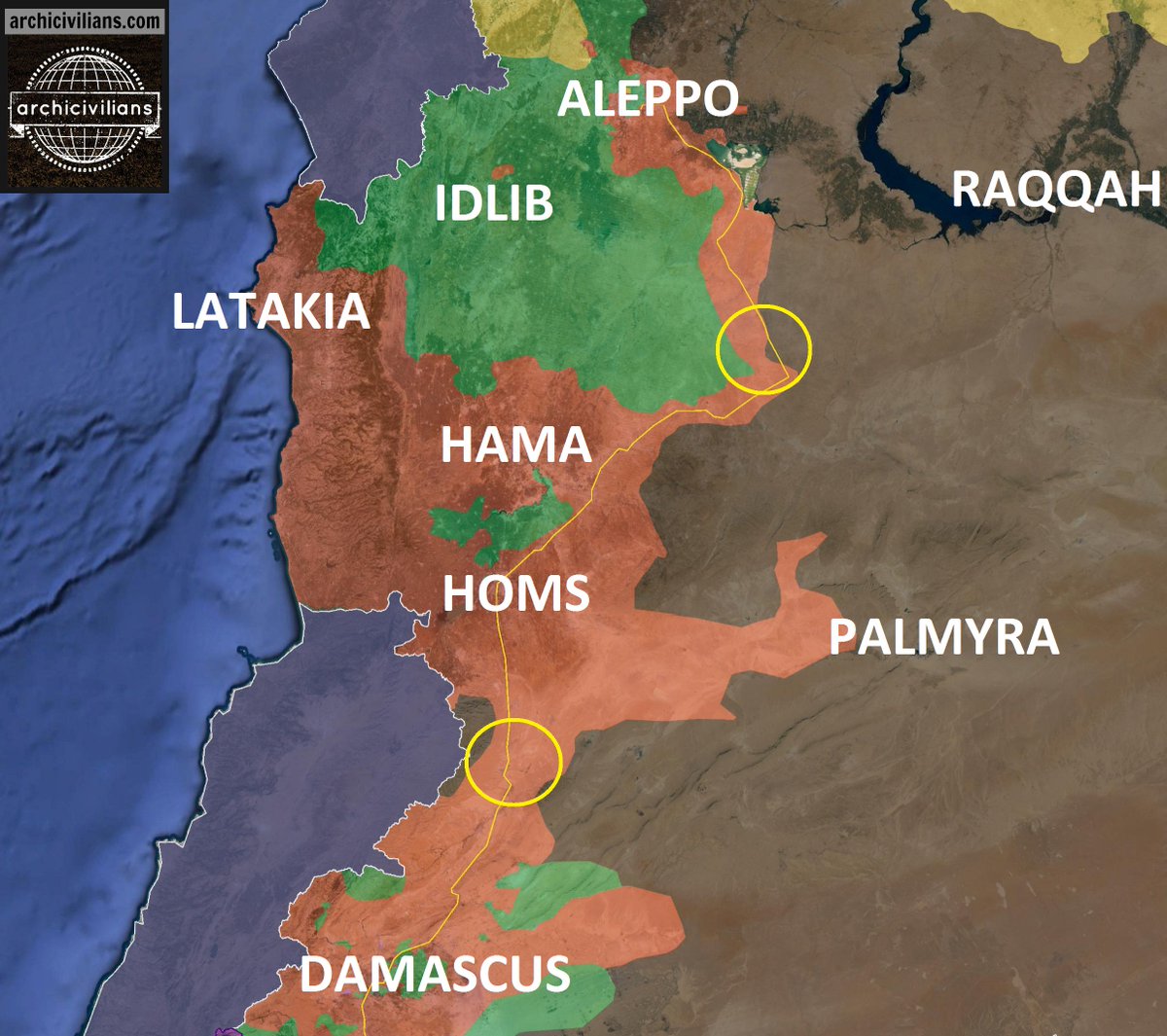
--LogFTW (talk) 02:45, 2 November 2015 (UTC)
If we all agree that there are clshes at least just to the east of Sadad how is Maheen-Sadad checkpoint red? shouldn't be green and add a partial black siege to the east of Sadad ? Helmy1453 (talk) 20:39, 2 November 2015 (UTC)
This is not a forum - no political or personal discussion here it's against the rules, just showing evidences Saddad is contested or i'll be change to red again in 24h --LogFTW (talk) 03:01, 2 November 2015 (UTC)
- LogFTW, "regime," was used properly, as the Syrian government is authoritarian in nature, and has an extremely socialistic economy, and because, "regime," can refer to a structured way of doing things. The word, itself, does not show bias, what shows bias is the context the word is used in. You're just looking for a reason to delete a comment you don't like. You sound like an intersectional feminist. Any edit in favor of any side, without a source we deem reliable, will be reverted. Latest word was that Islamic State fighters are in, and fighting for, the town. It will remain contested.
- Latest updates show the town as contested. You're telling us to prove that it's not contested? You have to prove that. We provided a link to a mainstream outlet showing the city as contested. Want it red? Provide a source that the town is under Syrian control.DaJesuZ (talk) 03:14, 2 November 2015 (UTC)
ISIS is near the Mahin Saddad checkpoint no inside the town
http://www.almasdarnews.com/article/christian-militias-fight-off-isis-terrorists-in-east-homs-maheen-sadad-checkpoint-recovered/
Source is pro gov but good credibility --LogFTW (talk) 04:40, 2 November 2015 (UTC)
The original source was stating 'on the outskirts of Sadad', that means 'just outside', but was also stating 'in nearby Sadad'. The point is that these sources reports information very indirectly (no source on ground) and are far less precise than our standard. Fpr them 'in' 'close to' 'on the outskirt' mean the same thing. On the other hand no other reliable source like SOHR or al-Masdar was stating the clashes were inside the town. The above source from AlMasdar states clearly the IS never entered the town and was later repelled also from its outskirt. Therefore the town goes red without ring.Paolowalter (talk) 06:57, 2 November 2015 (UTC)
Paolowalter SOHR also yesterday said that clashes between the regime forces and allied militiamen against IS militants are still taking place on the eastern outskirts of the town.http://www.syriahr.com/en/2015/11/airstrikes-carried-out-on-palmyra-while-explosion-takes-place-in-sadad-area-and-is-advance-toward-it/ Also source clear said that unable to penetrate town Sadad under control of Syrian troops and ISIS withdrew to Maheen-Sadad Checkpoint; however, as they fled Sadad, they were followed by a large contingent from SSNP that sought revenge for their fallen fighters in Maheen. SSNP soldiers struck ISIS’ defenses at the Maheen-Sadad Checkpoint and to impose full control over the Maheen-Sadad Checkpoint. also SSNP and NDF repelled ISIS’ large-scale assault on the small village of Hafr Al-Majawarat, which is located along the road to the predominately Christian town of Deir Attiyah.source 46.201.163.140 (talk) 07:11, 2 November 2015 (UTC)
Draw roads again!
Why the roads were deleted?
Draw it again ! --LogFTW (talk) 21:35, 2 November 2015 (UTC)
- Agreed. The map wasn't overly complicated or cluttered. Change the file to add the roads, again. DaJesuZ (talk) 00:13, 3 November 2015 (UTC)
- Someone said:
I reverted the change of the global Syria map definition from SVG to PNG. Either add the roads to an SVG version of the map (preferably), or specify the PNG as an AlternativeMap in the module. Re the IP, if you use Inkscape instead of MS Paint (or whatever it is you're using), it'll let you edit and save SVGs.
- Someone said:
- I'm guessing someone changed the existing map used in the background to have roads, and this was reverted because of use elsewhere. If this is correct uploading the map with the roads on as a new file, if done correctly should solve it, though people prefer the map to be stored as a SVG rather than a PNG. Banak (talk) 01:47, 3 November 2015 (UTC)
- I figured out a different way that does not use the global module. Further discussion of this topic should continue at #Map with Roads and Highways Ready above. That includes the reporting of any mistakes you can find in the highways & roads. Tradediatalk 03:19, 3 November 2015 (UTC)
- I do not agree with you. Please return to the old map. We are love old Syrian map . Selocan49 (talk) 05:34, 3 November 2015 (UTC)
- Just Put the road again --LogFTW (talk) 08:18, 3 November 2015 (UTC)
Ghammam
SOHR later reported that the regime forces again retake the whole village Ghammam. http://www.syriahr.com/en/2015/11/more-soldiers-in-the-regime-forces-killed-in-the-countryside-of-lattakia-while-the-regime-warplanes-hit-the-countryside-of-hama/ 46.201.163.140 (talk) 22:16, 2 November 2015 (UTC)
Also, if the roads are shown correct, Ghammam sits on the wrong side of the highway. I think a couple of villages in nothern Lattakia need to be repositioned. Could an experienced editor have a look on this? Oberschlesien1990 (talk) 10:29, 3 November 2015 (UTC)
- The position of Ghamman is correct. The roads are not correct in this area. Schluppo (talk) 10:53, 3 November 2015 (UTC)
- I uploaded a new Road map, which I tried to correct the roads near Ghammam . Please post the bugs and change requests in topic "Map with Roads and Highways Ready". 212.75.52.4 (talk) 11:58, 3 November 2015 (UTC)Mapmaker
Roads on map
I just added this section to thank every one who contributed in adding roads on the map. This is great. the best modification on this map since long long time. really happy with it. Helmy1453 (talk) 17:54, 2 November 2015 (UTC)
- I agree, the addition of roads to the map is very helpful indeed. Thanks! Schluppo (talk) 18:21, 2 November 2015 (UTC)
![]() Comment: I dont know wich user finally added the roads to the map, but I can only tell him: Thank you very, very much. As Helmy1453 states, its the best modification of the map since years ago. Cheers!--HCPUNXKID 17:10, 3 November 2015 (UTC)
Comment: I dont know wich user finally added the roads to the map, but I can only tell him: Thank you very, very much. As Helmy1453 states, its the best modification of the map since years ago. Cheers!--HCPUNXKID 17:10, 3 November 2015 (UTC)
Al-Madura
I just added this village contested in the map according to SOHR,if somebody have information who controls this village then please provide.Lists129 (talk) 17:32, 3 November 2015 (UTC)
- Curiously in the Amaq-statement, the location of al-Madura (or al-Mudawwira) is given completly wrong or at another place: 6 km west from Hawsh Hamad and only 3 km away from Daraa-Damascus-highway, which cannot be, cause Hawsh Hamad is 15-20 km away from the highway. Mughira1395 (talk) 21:21, 3 November 2015 (UTC)
al-Waddihi
Pro rebel source: Rebels fail their assault of village Al Waddihi. Village still under SAA. Video from rebels confirmed that their fighters still near this village.here 37.52.29.98 (talk) 07:03, 4 November 2015 (UTC)
- Not a reliable source. Schluppo (talk) 09:06, 4 November 2015 (UTC)
Adding military position/oil field items near Al Hawl
The following items seem to be relevant to recent clashes and could possibly be added to enhance accuracy of the map:
1. Fuel station northeast of Khatuniyah: http://wikimapia.org/#lang=en&lat=36.456084&lon=41.280441&z=12&m=b
Recently seized by YPG/SDF as per SOHR: http://www.syriahr.com/en/2015/11/the-democratic-syrian-forces-advances-over-is-in-hasakah-countryside/
2. Fuel station + military base west of Al Hol, presumably under IS control: http://wikimapia.org/#lang=en&lat=36.435647&lon=40.944672&z=12&m=b
3. Small military base east of Al Hol, under IS control: http://wikimapia.org/#lang=en&lat=36.404705&lon=41.217957&z=12&m=b
Some people will deem them small locations but I do have to note we already have bases near Hasakah and Qamishlo cities that are even smaller such as artillery positions, plus at least the oil stations offer more detailed info on resource control for the northeast, where we only have mapped a few select oil points.
190.67.225.32 (talk) 00:50, 4 November 2015 (UTC)
- We cannot add the first item because on Wikimapia there is a question mark next to its name. This means that the person who added it to Wikimapia is not sure. We only add items if we are sure about their exact location.
- We cannot add items 2. & 3. because military bases cannot be copied from wikimapia without a source mentioning them. See User talk:Hanibal911#Military bases added based on name in Wikimapia. Tradediatalk 09:09, 4 November 2015 (UTC)
- i think the editor is sure of it User:Lothar Von Richthofen
Khanasser-Ithriya Highway
SAA has been immersed in a fierce battle with ISIS for control of strategic Khanasser-Ithriya Highway that leads to the SAA controlled areas of the Aleppo Governorate. SAA received boost when Hezbollah arrived from town of Khanasser to help drive ISIS from long stretch of hills that are spread across this desolate area in Hama Governorate. Hezbollah/SAA recover integral hilltop at Tal Ithriya after a series of intense firefights with ISIS this has allowed for SAA to concentrate some of their units to Sheikh Hilal front, where they confronted another ISIS assault on this town located along Raqqa-Salamiyah Highway. SAA were able to defeat ISIS fighters attempting to push north towards town of Sheikh Hilal and also defeat another ISIS group which was try assault SAA positions near town of Al-Sa’an. Khanasser-Ithriyah Highway is still closed due to ISIS’ presence along northern hills overlooking main road that is used by SAA/allies if it still remains closed, SAA will have to rely on airdrops in order to resupply their forces in Aleppo. SAA/Hezbollah have less than 1km of territory left to go before the Khanasser-Ithriya Highway is reopened.http://www.almasdarnews.com/article/hezbollah-and-the-syrian-army-capture-tal-ithriyah-isis-controls-1km-of-highway-in-east-hama/ — Preceding unsigned comment added by 91.124.122.249 (talk) 12:26, 30 October 2015 (UTC)
- So what do you want ? Helmy1453 (talk) 14:05, 30 October 2015 (UTC)
- None of us expect the Islamic State to hold the highway. Such advances by them in the past have led to failure, push back, or encirclement. You saying, "Hey guys! Look at this!" doesn't give us anything on the map to chance. The map is still valid, and the article doesn't show otherwise. What's the point of this section, if I may ask? — Preceding unsigned comment added by DaJesuZ (talk • contribs) 17:29, 30 October 2015 (UTC)
Al-Masdar states that Tal ithriyah is under SAA control. Is it this place Jabal ithriyah?.Paolowalter (talk) 22:12, 30 October 2015 (UTC)
- I believe Tell Ithriyah is this hill: http://wikimapia.org/#lang=de&lat=35.354441&lon=37.760353&z=15&m=b.84.138.74.98 (talk) 22:53, 30 October 2015 (UTC)
Khanasar-Ithriah road is free again :Syrian Army Takes Control Over Key Highway Connecting Aleppo and Hama 212.75.52.4 (talk) 10:45, 4 November 2015 (UTC)Mazdak
Khanasser-Ithriya Highway
SOHR reported that the Khanasser-Ithriya Highway under total control of the Syrian troops after 12 days of clashes against of ISIS which is cut this highway earlier.http://www.syriahr.com/2015/11/%D9%82%D9%88%D8%A7%D8%AA-%D8%A7%D9%84%D9%86%D8%B8%D8%A7%D9%85-%D8%AA%D8%B3%D8%AA%D8%B9%D9%8A%D8%AF-%D8%A7%D9%84%D8%B3%D9%8A%D8%B7%D8%B1%D8%A9-%D8%B9%D9%84%D9%89-%D8%B7%D8%B1%D9%8A%D9%82-%D8%AE%D9%86/ http://www.dailystar.com.lb/News/Middle-East/2015/Nov-04/321563-syria-army-reopens-road-to-govt-held-parts-of-aleppo.ashx So that we need remove ISIS presence along of this highway. 37.52.29.98 (talk) 10:32, 4 November 2015 (UTC)
- Need more confirmation from other reliable sources, as this is a critical highway for the Syrian Regime forces. Also, Pro-Syrian Gov. sources have repeated stated that they would clear the highway "in only a few days" and that ISIL controlled less than 1 km of the road, but so far, nothing much has happened, and ISIL still controls around 13 miles of the road. In addition, the source you provided says that heavy clashes between Syrian Gov. and ISIL forces are still continuing along parts of the highway. LightandDark2000 (talk) 10:44, 4 November 2015 (UTC)
- Syrian Army Takes Control Over Key Highway Connecting Aleppo and Hama: Sputnik 212.75.52.4 (talk) 10:47, 4 November 2015 (UTC)Mazdak
- SOHR confirmed something: The english version: http://www.syriahr.com/en/2015/11/regime-forces-take-control-on-ethria-khnaser-road/ about fightings 1 km away from the already secured road. In the arabic original version http://www.syriahr.com/2015/11/قوات-النظام-تستعيد-السيطرة-على-طريق-خن , about 10 km to "completly secure" the road. Mughira1395 (talk) 11:46, 4 November 2015 (UTC)
- The daily star confirms this. Appropriate changes made.Ariskar (talk) 12:01, 4 November 2015 (UTC)
Changes around Al-Hawl
I'm reverting this edit by User:LightandDark2000 because he gave 2 sources and one of them gives no usefull information, while other is dead link. Also, some pro-Kurd sources are still talking about "5 km to go to Al-Hawl" and he even painted refugee camp on the edge of the city to yellow. Also, he uses really marginal sources like tweets from who-knows-who. --Hogg 22 (talk) 09:01, 4 November 2015 (UTC)
- Also, I would kindly ask everyone not to be too enthusiastic with turning everything around Al-Hawl in yellow. I red a lot of reports about YPG gains, but somehow they all fail to mention any of villages that should be on YPG's path if they are really making that much progress. Also, latest tweet from known Twitter Kurd shows virtually no progress. I don't know how much gains are real and how much imagined, but unless You have really god source to back up your changes, I would prefer to leave the map as it is.
- BTW, if someone can help me find village mentioned here, I would be grateful:
- Qeriya Elî, Rebîa, Bêt Hesûn and Sefiya, Salim Abu Kahla, south of Heseke & Miselis, 15 km southwest of Tal Barak, Şucae El-Faris, near Entakiya southern of Til Hamis. --Hogg 22 (talk) 15:49, 4 November 2015 (UTC)
Semi-protected edit request on 4 November 2015
This edit request to Module:Syrian Civil War detailed map has been answered. Set the |answered= or |ans= parameter to no to reactivate your request. |
Please change Morek to opposition control.
130.126.255.6 (talk) 20:58, 4 November 2015 (UTC)
Do you have a source ? Helmy1453 (talk) 21:35, 4 November 2015 (UTC)
- https://twitter.com/JulianRoepcke/status/662016484554776577
- http://www.aljazeera.net/news/arabic/2015/11/4/%D8%A8%D9%84%D8%AF%D8%A9-%D9%85%D9%88%D8%B1%D9%83-%D8%A8%D8%B1%D9%8A%D9%81-%D8%AD%D9%85%D8%A7%D8%A9-%D8%A8%D9%8A%D8%AF-%D8%A7%D9%84%D9%85%D8%B9%D8%A7%D8%B1%D8%B6%D8%A9
- --MD Syria (talk) 03:29, 5 November 2015 (UTC)
 Not done: please provide reliable sources that support the change you want to be made. That appears to be a twitter source.... Mdann52 (talk) 19:47, 28 November 2015 (UTC)
al-Hafr near Mahin
Pro-SAA site sana.sy claims:
- Meanwhile, the Syrian army air force destroyed fortifications and hotbeds of ISIS terrorists in al-Qaryatain city, Maheen town and the villages of al-Hadath and al-Hafr in the province countryside.
I cant find it. Could it be Hafar (we need disambiguation page here!), SW of Sadad, on Sadad-Damascus road. It was already attacked a few days ago. --Hogg 22 (talk) 12:08, 3 November 2015 (UTC)
Village Al Hafr under SAA. Reliable source said that unable to penetrate town Sadad, ISIS withdrew to Maheen-Sadad Checkpoint; however, as they fled Sadad, SSNP/NDF soldiers struck ISIS’ defenses at Maheen-Sadad Checkpoint and to impose full control over Maheen-Sadad Checkpoint. Also SSNP and NDF repelled ISIS’ large-scale assault on small village of Hafr.source 95.132.204.253 (talk) 12:31, 3 November 2015 (UTC)
When reports from the SANA translat from Arabic on the English language a lot of mistakes in the translation and the translated reports are too distorted. In original report was said airstrike near city but in translated was said that airstrike inside city. I think we dont need use reports from the SANA on English. 95.132.204.253 (talk) 12:38, 3 November 2015 (UTC)
The article was published in english by an english speaking reporter, it has not even been translated the source is valid in english. — Preceding unsigned comment added by 193.1.100.60 (talk) 13:55, 3 November 2015 (UTC)
According to @desyracuse Sab Bayar and the mountains towards ISIS have fallen http://www.agathocledesyracuse.com/archives/527 — Preceding unsigned comment added by 2601:741:0:9182:D509:48DC:24D8:3A1 (talk) 14:13, 3 November 2015 (UTC)
- Yes, but I was not able to find any source confirming it, not even any fighting-reports. Maybe somebody has any information.Mughira1395 (talk) 21:13, 3 November 2015 (UTC)
- Nothing new about Saba Bayar / Saba Abyar? Mughira1395 (talk) 11:16, 5 November 2015 (UTC)
Is it just me or ...
Sometimes I feel like all sides in the conflict just made up some arbitrary village names and claim they just conquer it. Take this example: Syrian Army Advances North Towards the Idlib Border After Successful Operations in Northeast Latakia which says:
- Following a series of intense firefights, the Syrian Armed Forces powered through the Islamist rebel defenses and imposed full control over the villages of Khandaq Al-Khamou, Mafraq Beit Abu Reesha and Khirbat Jubb Al-Za’rour, which are located directly north of the strategic hilltops of Jubb Al-Ahmar
I'm looking at the wikimapia and I can barely find Jubb az-Zu'rur which sounds remotely similar to Khirbat Jubb Al-Za’rour and it's not N but E-NE of Jubb Al-Ahmar. Other two villages are non-existing. Zero. Nada. Null. I only find Arafit, Musharaf, Ikko, Zuwayqat, Kabanah, Rouyasset Iskandar (without a single house in it), Duweir al Akrad and Barisha. Rest of the map is without houses, so I don't think this is the case of missing a few labels on the map. It's the same with mapcarta.com. So, is it just me or ... --Hogg 22 (talk) 08:18, 5 November 2015 (UTC)
- here Detaild Map North Latakia Front you have the village khandaq al Khamu (خندق خامو) located southwest to Jib Al Ahmar and other location you mentioned. 212.75.52.4 (talk) 08:32, 5 November 2015 (UTC)MapMaker
- The problem is, that the location aren't always villages, but could be also hills or plain etc, and Masdar etc. aren't always aware about it. "Khandaq al-Khamu" could be a town-name, but literally it means only "Khamu-rift/small valley". Take also the fightings aroud Sadad: They mention fightings on hills or mountain chains, which I did not find too. Mughira1395 (talk) 11:11, 5 November 2015 (UTC)
- This source here has very reliable and detailed maps, although from Iranian side. But very correct reports from fronts and battle fields. It is also refreshed almost once a day.--212.75.52.4 (talk) 11:27, 5 November 2015 (UTC)MapMaker
- The problem is, that the location aren't always villages, but could be also hills or plain etc, and Masdar etc. aren't always aware about it. "Khandaq al-Khamu" could be a town-name, but literally it means only "Khamu-rift/small valley". Take also the fightings aroud Sadad: They mention fightings on hills or mountain chains, which I did not find too. Mughira1395 (talk) 11:11, 5 November 2015 (UTC)
Please change Al-Aziziyah from green to contested! It's south of Al-Hader in South-Aleppo.
Pro-Oposition SOHR confirm that SAA is advancing in Al-Aziziyah south of Al-Hader http://www.syriahr.com/en/2015/11/the-clashes-continue-in-the-southern-and-eastern-countryside-of-aleppo-while-russian-warplanes-hit-the-southern-one/ — Preceding unsigned comment added by 81.161.115.2 (talk) 12:16, 5 November 2015 (UTC)
Most of the place names on this map here are wrong spelling in English, they all have Abu added. All the places on our map are totally mis alligned with where they are supposed to be. Wikimapia is only somewhat reliable, use a proper geographic map. — Preceding unsigned comment added by 193.1.100.66 (talk) 19:04, 5 November 2015 (UTC)
Damascus map
Damascus map is out of date due to advance of SAA norht of Douma and close to Merj al Sultan. It should be updated. tha talk page of the map is not used since months. I just reverted it to a more plausible map but is still incorrect.Paolowalter (talk) 23:01, 5 November 2015 (UTC)
Not just Damascus but DEZ as well, heck I'm pretty sure I've seen more up to date maps as the map than the current one from August, even pro-gov maps show Saqr island as ISIS held at this point — Preceding unsigned comment added by 2601:741:0:9182:3159:AE01:B1EA:1C2 (talk) 03:54, 6 November 2015 (UTC)
- Regarding Saqr island, even Al-Mazdar says ...but unfortunately for ISIS, they were given no relief from as the Russian Air Force chased them to Sakr Island.. --Hogg 22 (talk) 08:05, 6 November 2015 (UTC)
Aleppo detail map is also out of date; IS controls Tal Riman since a few weeks, yet the map shows it to be controlled by SAA. Schluppo (talk) 10:58, 6 November 2015 (UTC)
New icons for oil fields
![]()
![]()
![]()
![]()
![]()
What do You say? --Hogg 22 (talk) 13:40, 6 November 2015 (UTC)
- I think changing oil fields to a specific icon would be a good idea to distinguish them from other industrial complexes on the map as they hold their own unique strategical value - they're economic importance - particularly to opposition groups. However the icons you propose I would argue don't match the same standard of professionalism of the map. Instead may I suggest an icon based on the image of an oil pump?Prohibited Area (talk) 15:56, 6 November 2015 (UTC)
- Indeed, this seems like a good idea. 89.10.99.244 (talk) 18:03, 6 November 2015 (UTC)
- I agree as well (per all). It makes what kind of industrial complexes it is and such (in other words, being specific.) But yeah, try to make a more better icon so that readers can understand more. --Damirgraffiti |☺What's Up?☺ 22:51, 6 November 2015 (UTC)
- Indeed, this seems like a good idea. 89.10.99.244 (talk) 18:03, 6 November 2015 (UTC)
I think such things as oil platforms and roads must be neutral to civil war parties. One can easily guess who controls them . — Preceding unsigned comment added by 2003:6A:6740:5E82:2C7D:F594:9E86:6DB (talk) 19:29, 6 November 2015 (UTC)
I think it´s a go!Rhocagil (talk) 02:24, 7 November 2015 (UTC)
rebel controlled Ma'an
according to this pro-rebel map the rebels captured it https://pbs.twimg.com/media/CTIBXQ9W4AAAVfn.png
Draw maan on map again — Preceding unsigned comment added by 190.203.111.40 (talk) 16:19, 6 November 2015 (UTC)
No reliable source is indicationg this. clashes are still outside of Ma,an. Helmy1453 (talk) 18:01, 6 November 2015 (UTC)
But it's not on map draw it.
Ma'an is on the map just east to Morek , south of Atshan and north of Kubarriah.red and have agreen siege from the right. Helmy1453 (talk) 19:56, 6 November 2015 (UTC)
Ma'an is not controlled by rebels. They are 2 to 3 KM away, near the village of Mantana (which is not on this map, was taken by rebels yesterday). Tell Othman is, however. In another post here there was a map of Petro Lucem (Twitter, editor in chief of Al-Masdar) which showed Tell Othman as rebel held and an-Bani as contested. Archicivilians later confirmed this in his own map. The hill should be green. — Preceding unsigned comment added by 84.24.43.183 (talk) 12:26, 7 November 2015 (UTC)
I no see Maan on map atm btw — Preceding unsigned comment added by 190.203.111.40 (talk) 19:37, 7 November 2015 (UTC)
Hasakah South Dam
Seeing as we have mapped both East and West Dams in near Hasakah city, the South Dam would be a welcome addition to the map in particular since it's likely to become a target for SDF/YPG if they advance further south, of course since it's deep inside Daesh controlled territories it can be added as black safely: http://wikimapia.org/#lang=en&lat=36.268082&lon=40.788116&z=11&m=b&permpoly=883098 186.119.61.232 (talk) 20:52, 7 November 2015 (UTC)
Southern Aleppo
Rebels have retaken hills south of Al-Wahidi town. They are also in firm control of Khan Tuman. Hadir is shown as contested, whist even Al-Masdar claims the SAA and Hezbollah are only "near Hadar city". Rebels have also retaken the village of Shugaydilah, near Hadir.
Sources:
- http://aranews.net/2015/11/al-nusra-front-allied-syrian-rebels-fight-back-in-aleppo/
- https://english.alarabiya.net/en/News/middle-east/2015/11/07/Despite-Russian-strikes-Syrian-rebels-hold-ground-.html
- https://now.mmedia.me/lb/en/commentary/566160-looking-to-lock-it-down — Preceding unsigned comment added by 84.24.43.183 (talk) 19:05, 7 November 2015 (UTC)
0 reliable source, none of the 3 articles are mentioning Shugaydilah nor any orc supporter claiming it, it still got edited. SAA/Hezbollah has taken Aziziyah and Tal Mamou south of Hader http://www.almasdarnews.com/article/breaking-syrian-army-and-hezbollah-capture-tal-mamou-and-aziziyah-in-southern-aleppo/ Totholio (talk) 09:38, 8 November 2015 (UTC)
SAA advance near Aleppo
Syrian Army/NDF) captured villages Tal Dadeen, Khirbat Al-Shalash, al-Shughaydilah and town of Hadidi and directly east of Al-Hadher. Also SAA advancing inside Kafr Haddad. http://www.almasdarnews.com/article/syrian-army-and-hezbollah-make-huge-gains-in-southern-aleppo-military-operations-begin-in-al-hadher/ 46.201.163.140 (talk) 07:34, 2 November 2015 (UTC)
Tel Dadeen is south west of AL Hadir not in north Aleppo 86.135.154.78 (talk) 20:38, 3 November 2015 (UTC)
Can anyone add the villages and towns south and west of Hadher? Tall-Bajir, Banes, Huwayr, Zawar, Jazaira... they still don't figure on the map — Preceding unsigned comment added by 2A01:E35:2E80:BB10:C01B:6A33:339A:262A (talk) 16:08, 8 November 2015 (UTC)
Road map to the Syrian_and_Iraqi_insurgency_detailed_map
Maybe there was a thread about this in summer, but do anybody know about who is in charge/responsible for the Syrian and Iraqi detailed map? I am just asking, because of the new road map (which is absolutly a great work!), if it could also be integrated there (even if it will be only for the syrian part of the map). Thanks! Mughira1395 (talk) 21:29, 3 November 2015 (UTC)
- I made the Syria roads. Do You want this also for Irak map (here)? Or there is an other map which includes both Irak and Syria? 212.75.52.4 (talk) 11:21, 4 November 2015 (UTC)MapMaker
- I mean this map: https://en.wikipedia.org/wiki/Template:Syrian_and_Iraqi_insurgency_detailed_map which is a combination of both maps. I you can do that also for the iraqi side, it will be a really great job! Mughira1395 (talk) 11:38, 4 November 2015 (UTC)
- I found and checked the map. The two maps are slightly different. for example Syria has in the double map, measure deviations against Syria in the single map.This makes a copy or roads from one to other difficult, because the positions onf Cities are indeed very precise . But I will try to make it. 212.75.52.4 (talk) 11:50, 4 November 2015 (UTC)MapMaker
- Just to inform you: The changes in the single maps are also done (automaticaly?) in the doubble map. And for the iraqi map, the double one is clearer - look for Ramadi for instance. Mughira1395 (talk) 12:21, 4 November 2015 (UTC)
- Now I made a try and put the roads in the double map, but only for Syria as first step. Syria+Irak map with syria Roads. How to replace it? Please read the Topic " Roads ..." Above. Whether the map is good or not, can be seen after replacement. 212.75.52.4 (talk) 13:31, 4 November 2015 (UTC)MapMaker
- Just to inform you: The changes in the single maps are also done (automaticaly?) in the doubble map. And for the iraqi map, the double one is clearer - look for Ramadi for instance. Mughira1395 (talk) 12:21, 4 November 2015 (UTC)
- What do you mean?. Mughira1395 (talk) 22:44, 4 November 2015 (UTC)
- I just uploaded your new Syrian_and_Iraqi map and it seems to work fine. Tradediatalk 04:39, 5 November 2015 (UTC)
- Absolutely great work. Thanks a lot! Although the iraqi map is not really up-to-date, if "somebody" could make also the roads there? :-))Mughira1395 (talk) 11:13, 5 November 2015 (UTC)
- Perhaps "somebody" will try to do that , maybe till next week, sooner or later! 212.75.52.4 (talk) 12:47, 5 November 2015 (UTC)MapMaker
- Absolutely great work. Thanks a lot! Although the iraqi map is not really up-to-date, if "somebody" could make also the roads there? :-))Mughira1395 (talk) 11:13, 5 November 2015 (UTC)
Iraq+syria+Roads for both countriess now ready to upload here . --2003:6A:6740:5E82:91FE:3F06:C24A:F2B4 (talk) 17:38, 8 November 2015 (UTC)MapMaker
JAN in southern Hama
Four towns in southern Hama are now GREY JAN held is this a resent advance or has some one just added them ? 86.135.154.78 (talk) 14:15, 8 November 2015 (UTC)
- This four town were rebel held until JAN attacked and siezed them.SOHR.Lists129 (talk) 18:07, 8 November 2015 (UTC)
Thank you MapMaker!
for your map-improvement (roads) on this map: https://en.wikipedia.org/wiki/Template:Syrian_and_Iraqi_insurgency_detailed_map As somebody already said, it is maybe the most important map-improvement of the last years. Mughira1395 (talk) 07:05, 9 November 2015 (UTC)
- You are welcome. If there is any mistakes or other requests for improvement or railroads etc. , please ask that in the main topic for roads ('Map with Roads and Highways Ready' ) and I will check it. --212.75.52.4 (talk) 12:01, 9 November 2015 (UTC)MapMaker
ISIL Supply route to East Homs/Hama
Is their a road which connects the ISIL presense in East Homs/Hama to the rest of the ISIL held territory? On the map their is an icon indicating a n ISIL supply route, does this supply route indicate a road used by ISIS to supply its forces or is it just a route used by ISIS across terrain? If there is a road can someone please add it to the map? Thanks.Prohibited Area (talk) 15:23, 8 November 2015 (UTC)
- There is a road there that leads from Mafkar al Gharbi to Fakhr, but it ends there, on our map, at least. If I were to guess, this road connects to the Al-Ithriyah-Palmyra highway, but I haven't looked at a map, so I don't know, exactly. DaJesuZ (talk) 20:16, 8 November 2015 (UTC)
- Yes There is a road branch via 'Al-Mushayrifah' and 'Bustan Sabih' to Palmyra road, but this part is under SAA. I will add the in the next correction-Map ---212.75.52.4 (talk) 12:31, 9 November 2015 (UTC)MapMaker
Semi-protected edit request on 8 November 2015
This edit request to Module:Syrian Civil War detailed map has been answered. Set the |answered= or |ans= parameter to no to reactivate your request. |
Please change the icon for the Morek tank brigade checkpoint from village to military base Oberschlesien1990 (talk) 22:38, 8 November 2015 (UTC)
 Done! Schluppo (talk) 12:50, 9 November 2015 (UTC)
Ma'an village no visible on map
Ma'an village no visible on map some one draw that — Preceding unsigned comment added by 190.203.111.40 (talk) 23:26, 8 November 2015 (UTC)
- Again: Ma'an is on the map, east of Morek. 109.43.3.206 (talk) 14:53, 9 November 2015 (UTC)
Syrian Arab Army Capture Sheikh Ahmad, Aleppo Governorate less than 2 km from Kuweires Airbase
SAA capture Sheikh Ahmad: http://www.almasdarnews.com/article/cheetah-forces-advancing-to-the-kuweires-airport-after-capturing-the-strategic-town-of-sheikh-ahmad/ — Preceding unsigned comment added by 193.1.100.66 (talk) 16:32, 9 November 2015 (UTC)
In base of what it's make contested again ? — Preceding unsigned comment added by 200.84.36.197 (talk) 18:21, 9 November 2015 (UTC)
There have been a flurry of confusing edit about Sheikh Ahmad. It is taken by SAA but it must be marked so on the Aleppo map not on the main one. The main map reports only military site. In this regard I added the military housing that appear to be contested from AlMasdar article. Why was it changed to red? Please refrain from additional edit without consensus. Paolowalter (talk) 19:07, 9 November 2015 (UTC)
Clashes betwen pro ISIS forces against Al Nusra in Daraa province
SOHR: Clashes taking place between Jabhat al-Nusra and SHohadaa al-Yarmouk in Saham al-Jolan amid reports of advance the Shohadaa al-Yarmouk.http://www.syriahr.com/en/2015/11/clashes-in-dara-and-bombardment-on-the-yarmouk-camp/ So that the town of Saham al-Jolan conteted between JAN/ISIS. 95.135.243.88 (talk) 11:31, 10 November 2015 (UTC)