
Talk:List of mountain peaks by prominence/Archive 1
| This is an archive of past discussions. Do not edit the contents of this page. If you wish to start a new discussion or revive an old one, please do so on the current talk page. |
| Archive 1 |
Flags
Can someone change the flag by Mount Cameroon to Cameroon's rather than Cambodia's? I can't figure out what the proper three-letter code is. BrianSmithson 23:19, 6 August 2005 (UTC)
Sorry, my mistake. It is now fixed. The code was {{CMR}} incidentally. --Stemonitis 07:59, 7 August 2005 (UTC)
Key Saddle Data Source
You correctly cite [1], but then state that the saddle data is derived from "satellite images, probably more accurate than maps".
That is not correct. Satellite images are not more accurate than maps. I updated the saddle data on [2]from digital elevation models supplied by SRTM based on radar interferograms. For most of the world, these are more accurate than maps.
Please update this in the main article.Viewfinder
Amendment not carried out so I amended it myself Viewfinder
Kongur Tagh: Chinese sources disagree, some give 7719m, some 7649m. The strong evidence supporting the lower elevation can be found [here]. Viewfinder 21:56, 10 November 2005 (UTC)
I have deleted the link to a table which contains inaccurate prominences. The author has told me he will update this table; the link will then be restored. The inaccuracies are only in the prominence column of the table concerned; in general I have a high regard for the site that hosts this table. Viewfinder 23:14, 1 December 2005 (UTC)
Mount Hermon prominence and other additions
I have chosen to revert, rather than correct, the Mount Hermon addition by an anonymous user with no knowledge of prominence. Wikipedia should be discouraging this sort of thing. For the correct prominence, go to [3]. I welcome selective additions to Wikipedia's prominence lists, and the addition of prominence to the boxes of the individual Wikipedia mountain pages, but I do not want there to be more and generally longer prominence or height lists on Wikipedia because I do not think Wikipedia adequately credits the researchers, none of whom are paid to carry out their research. The external links to the various prominence sites on the web are adequate. Viewfinder 09:01, 17 February 2006 (UTC)
- I have replaced that addition, and updated it. In general, it is better to encourage potential editors than to discourage them. Wikipedia does credit the researchers, by citing them; that is what the External links and References sections are for. --Stemonitis 09:11, 17 February 2006 (UTC)
While I expected, accept and have added to your replacement, I think that there is too much misinformation on Wikipedia so I decided to make a point. On the subject of external links and references, these are generally at the bottom of long lists and are frequently not seen. In theory, much of the prominence information on Wikipedia could be reverted on copyright grounds. I do not want that to happen because I want Wikipedia to continue to promote prominence, but not all my research colleagues agree. I think the balance is about right at present; the correct addition of a limited number of the best known summits, like Mount Hermon, would be good.Viewfinder 10:32, 17 February 2006 (UTC)
- A relative height is a fact, and is ineligible for copyright. If the presentation of the relative heights were copied (e.g. wholesale copying of the tables, maps etc. from those excellent websites), then there would be a copyright issue, but not when just using the numbers. Still, until Wikipedia has comprehensive information on all mountains, it will never become a serious rival to the prominence sites, and we haven't got a problem. I appreciate your concerns but I think they're at best a little premature. --Stemonitis 10:48, 17 February 2006 (UTC)
"A fact... is ineligible for copyright" is an interesting observation indeed. Later today I will comment on that on my talk page. Viewfinder 13:47, 17 February 2006 (UTC)
Lists of mountains
Normally I handle articles on birds and animation, but after stopping by your userpage, I felt compelled to do a mountain list of my own. Of course, I decided to cover an area I know somewhat better than the British Isles: List of mountains and hills of Arizona by height. Hope it's up to snuff.
Next up: replacing the horribly inadequate List of mountains in Japan with a comprehensive list comparative to what we've got for the British Isles and Arizona. (Good thing I can read Japanese!) At some point in time I need to cobble up relative height / prominence lists for Arizona and Japan as well, but one thing at a time, right?
Hope you don't mind me using your formats for these. Cheers and have a good Wiki day! -- Miwa 00:07, 24 March 2006 (UTC)
A cut-off for the list?
Recent additions have been including smaller and smaller mountains, and there's no knowing where it'll end up. I would like to suggest we set a voluntary cut-off of something like 2 000 m realtive height for inclusion on this list (which, by my calculations would then include something like 234 mountains, worldwide). Dropping the cut-off to the height of Carrauntoohill would increase the list's size (were it to be comprehensive) to around 800 peaks. Another quick calculation suggests that we can fit about 200 peaks into the tables before we hit the 32 kB recommended limit for articles. It would seem a shame to undo people's efforts in adding mountains here, but then again, mountains the size of Carrauntoohill really aren't significant on a global scale. --Stemonitis 16:08, 1 May 2006 (UTC)
- In principle, you are right, but I think there is still room for mountains that, like Ben Nevis, Carrauntoohil, Hermon, are well known to a high percentage of Wikipedia readers, and these are preferable to lesser known mountains even if they are less prominent. I think there is a case for having the top 100, plus another 50-100 selected not by pure prominence rank, but because they are well known and readers might like to know their prominences. For example, spectacular mountains like Matterhorn and Mount Kailash, which have relatively low prominence but are highly ranked by "spire measure", would be acceptable additions for me. But if we all start adding our personal favorites, we will need start wielding our axes. This is becoming a problem on some other mountain sites, which have been growing in a disorganised manner. Viewfinder 18:30, 1 May 2006 (UTC)
- By the way, Stemonitis, www.peaklist.org lists over 1500 peaks with >1500m of prominence, so dropping down to 1000m would give at least 3000 peaks. Obviously we can't go that far (though you have to admit it would be cool). --Mark J 20:40, 6 May 2006 (UTC)
Low prominence peaks
I have added some of these in the additional peaks section, for the benefit of readers who do not understand why they are not in lists ranked by prominence. The inclusion of these, which are often cited by opponents of the prominence concept, may seem wrong. But, although these mountains are the most impressive, they are either not the high points of their local ranges, or their ranges are not separated from other ranges by low passes. Prominence favours continental, regional and local high points; for impressiveness, other measures should be considered. — Preceding unsigned comment added by Viewfinder (talk • contribs) 16:39, 18 May 2006 (UTC)
Mont Blanc and other snow and ice capped peaks
The most commonly quoted elevation for Mont Blanc, which appears on most maps, is 4,808 m. This is supported by [4] (see page 8). Some authorities and measurements give 4,810 m. In reality, there is no definitive correct elevation because the thickness of the snow and ice cap varies. It would therefore seem best to stick to the long accepted 4,808 m, and for similar reasons, to 8,848 m for Everest. Note that the summit of the snow cap is always taken as the summit when Mont Blanc, and most other summits, are measured. This policy should be applied consistently. Authorities who breach it by claiming or implying that the 8,844 m rock head elevation of Mount Everest measured by the Chinese in 2005 is its true height should be corrected. Viewfinder 12:13, 27 May 2006 (UTC)
Parent peak?
This table is a mess, but chiefly, I want to ask how "parent peak" is being defined here. Given that the relative height (topographic prominence) is the difference between the absolute height of the summit and the absolute height of the col separating it from any higher summit, I have always used the highest of those other higher summits as the parent. This seems to me to be the only objective way to do it. It makes no sense to have a "parent" coming after a "child" on the list. By my method, a parent is not only higher (absolute) than its child, but also has greater relative height (topographic prominence). One can, therefore, merely scan up the list to see which peaks are possible parents of a given peak. Relatively few of the peaks on this list have got their parents listed so far anyway, so it would not be too hard to replace them with true parents, rather than the nearest higher peak the other side of the col. It would also prevent glaring errors like Damavand being listed as the parent of Elbrus, even though it's lower. Any objections? --Stemonitis 08:59, 27 Apr 2005 (UTC)
- Well, I've been bold, in the absence of any nay-sayers, and made those changes. Someone had requested a column for the col height, so I've put that in. I've also added in the parents for as many as I could work out. Most of them must be true from pure logic, but there are a few where I've made educated guesses which could be wrong, and a few I couldn't work out. In particular, someone who understands Asian mountain geography better than me would do well to sort out the remaining orphans. --Stemonitis 12:56, 6 May 2005 (UTC)
Well, the parent peak of a mountain (as defined in the source websites) is the topographically nearest higher peak - the peak from which its prominence is calculatd. It's a little unreasonable to regard Mont Blanc as a subpeak odf Everest, when clearly from a Caucasian point of view it's little more than a shoulder of Elbrus. :-) This was the definition I had in mind when Gdr and I created this page. Thanks for all your work on the paghe, thjough - it was me who made the above request. --Mark J 20:39, 7 May 2005 (UTC)
I do not see how Everest can be Kilimanjaro's parent, as it is on a different continent and different continental plate. The plates just happen to be touching at the moment, although the Suez Canal is now between them. Unlike the Panama Canal, it is at sea level, so I do not see why it should not count as a separation. If the prominence can go underwater and across continents like that, then wouldn't Everest be the parent of every other mountain on Earth? -- Kjkolb 17:43, 16 September 2006 (UTC)
- Before the artificial Suez canal was built, it was possible to go from Africa to Asia without descending lower than 10 metres. There is plenty of debate within the prominence community about whether these artificial phenomena should count, but at present the standard practice is that they do not. By the definitions of island parentage and prominence parentage, which you can read in the prominence article, Everest is Kilimajaro's parent. By height parentage, a lower peak than Everest (about 6,000m) along the ridge to Everest will be the parent. I do not know what that peak is and I am not convinced there is a rigid definition. But no, Everest is not the parent of all Africa/Eurasia, by any definition; read the definitions carefully. Viewfinder 19:56, 16 September 2006 (UTC)
- Elaborating on Viewfinder's last sentence: Everest is an ancestor of every peak on Earth, in fact the "oldest ancestor"--think "Adam", if so inclined. But it is not the parent of every peak, just as Adam would not be the parent of every human. Mountains have parents, grandparents, and whole lineages of ancestors. This is true using any definition of "parent", although different definitions will yield very different lineages. -- Spireguy 20:14, 16 September 2006 (UTC)
- Expanding that thought a little more: I would not list e.g. Aconcagua on this table as having "no parent"---I would say that its parent is in fact Everest. That way no special cases need to be excluded. But I'm not dogmatic about it. See the topographic prominence page or its talk page for more. -- Spireguy 20:18, 16 September 2006 (UTC)
- (Edit conflict, I have not read the above yet, I'm going to bed) I meant by prominence only and I know that mountains far apart can be parents and children according to the definition, it just seems like the definition is taken to such an extreme that it does not have much meaning. As for all of the peaks having Everest as the parent, I stated that completely wrong (it's been a long night). I actually meant every peak that would have Everest as a parent, if being separated by the ocean did not matter. Anyway, if that is what the experts consider it to be, then that is what we should have. It just seems hard to believe. Thanks, Kjkolb 20:28, 16 September 2006 (UTC)
- I guess I qualify as an expert, but I don't pretend to be authoritative. I agree that the "parent" of a peak becomes a less useful notion the further away that parent is. This is especially a problem for the prominence island parent; see the prominence page and its talk page. But that doesn't mean that the parent can't be said to exist. Now, I'm a mathematician, and I'm used to a definition covering all cases, even extreme special cases; that is elegant and simple, and those are core mathematical values. Other people have different preferences. -- Spireguy 03:25, 17 September 2006 (UTC)
Mount Sidley Parent
I doubt the parent of Mount Sidley can be Mount Gardner, since Gardner does not appear on peaklist's List of Antarctica Ultra-prominences. I probably knew the actual parent at one time when I was researching this stuff, but I must say I have forgotten. It seems that it must be either Vinson Massif, Mount Minto, or Mount Kirkpatrick. Anyone want to clear this up? Viewfinder, maybe? -- Spireguy 04:26, 1 March 2007 (UTC)
- The island parent has to be Vinson. I am not sure about other definitions of parentage, I find these confusing and I still do not think they are rigidly defined. Btw the USGS GNIS says 4285m but the USGS 250k topo says 4181m. Any comments on which is more accurate? Viewfinder 07:11, 1 March 2007 (UTC)
- Sorry about that, I was using the "Nearest Higher Neighbor" info from Peakbagger when I added Sidley to the list. But I guess that only gives the height parentage, and the list is using island or prominence parentage. By the way, Spireguy, I noticed you added the prominence to the Sidley article . . . but that prominence is based on the 4285m elevation, not 4181 as listed. So either the elevation or the prominence needs to be changed for consistency. Seattle Skier 09:13, 1 March 2007 (UTC)
- In general I would say that the 250K map would be more accurate; GNIS is noted for having a number of errors. However Antarctic mapping is pretty unreliable. I would go with the 250K unless there is some reason to do otherwise (besides the GNIS); I'll try to see if I have any info to clear it up. Damien Gildea's articles on Antarctica might mention Sidley. -- Spireguy 02:35, 2 March 2007 (UTC)
Timor HP
I reverted the addition of Ramelau because it was already shown as Tatamailau 2986m. Timor cannot have two high points. But both the name Ramelau and height 2963m may be more accurate. Any comments? Viewfinder 23:28, 13 December 2006 (UTC)
- Currently, Gunung Tata Mailau redirects to Mount Ramelau, which begins,
- "Mount Ramelau, or Mount Tatamailau, is the highest mountain in East Timor at 2963 metres. ..."
- Not many hits on google for 'Ramelau Tatamailau' that don't look like wikipedia or copies thereof, but Time magazine had a story in 2002 saying:
- "Mount Ramelau, or Tatamailau, as the maps label it, was once the ... the 2,963-m-high peak ..."
- An article in a Portuguese Navy magazine (Portugal was the colonial power) says,
- "Tatamailau, o pico mais alto da montanha do Ramelau. Com os seus 2996 metros de altitude, ..." I take this to be saying that Tatamailau is the name of the mountain and Ramelau is the name of the range.
- The report of an Australian conference on East Timor says,
- "The highest mountain with a height of 2,963 metres is the Tatamailau peak of the Ramelau Range in the Ainaro district."
- Searching for 'Gunung Tata Mailau' finds
- Tata Mailau, 2986 meters on peakbagger.org and
- Foho Tatamailau 2986 on peaklist.org
- —wwoods 01:52, 14 December 2006 (UTC)
- I corrected the location of this peak. It is in East Timor, not Indonesia. Its page still have 2,963 m as height. Zdtrlik 17:37, 9 April 2007 (UTC)
Coordinates in degrees?
I would recommend if someone add a column for coordinates of the peaks. Same as what we have in List of highest mountains. —Preceding unsigned comment added by 213.207.243.65 (talk) 11:30, 3 October 2007 (UTC)
Zugspitze
I don't know what the parent(s) of Zugspitze is/are. According to peakbagger, its key saddle is at 1,216m, at 47°22′N 10°50′E / 47.367°N 10.833°E
—wwoods 14:44, 22 June 2007 (UTC)
- The highest point within the ring contour on the other side of that col is Mont Blanc (along with most of the Western Alps), which is therefore the island parent. The other definitions of parentage have never really meant much to me, so I can't say much about them. --Stemonitis 15:39, 22 June 2007 (UTC)
where is k2? —Preceding unsigned comment added by 24.177.35.135 (talk) 11:11, 5 November 2007 (UTC)
- It's number 22. It may not be all that close to Mount Everest but it is part of the same Himalaya range and therefore not the highest peak in its range. Viewfinder 03:19, 6 November 2007 (UTC)
San Jacinto Peak/Mount San Gorgonio
Mount San Gorgonio (3506m) is the hightest peak in Southern California, and San Jacinto Peak tops the second-highest range (3302m) about 35km away. But San Gorgonio's prominence is 2524m while that of San Jacinto is 2533m. They are sixth and seventh most prominent in the contiguous U.S.[5] San Jacinto is also notable for the steep Snow Creek escarpment, which gains over 2500m in just 11.3km of distance. For those reasons I propose replacing replacing San Gorgonio on the list "Additional peaks" with San Jacinto. Any objections? ·:· Will Beback ·:· 23:13, 25 November 2007 (UTC)
table still a mess
This table is still a mess, several parent peaks are listed on the wrong mountains. I still don't completely understand the definitions, so if someone who knows a little more about the subject could attempt a cleanup it would be great. RichMac (Talk) 15:54, 29 November 2006 (UTC)
The definitions of prominence and parents are given on the topographic prominence page. Please study them, give some examples to support your claim that pareant peaks are wrongly listed, and refrain from unsupported comments like "table is still a mess". Thanks. Viewfinder 16:03, 29 November 2006 (UTC)
I also have no idea what the "still a mess" comment refers to. Specifics, please? -- Spireguy 22:55, 29 November 2006 (UTC)
I guess this is an old conversation, but I agree the table is a mess. How is Aconcagua the parent of MtMcKinley which is 5,000 miles away? My impression was that parent peaks had to be in the same range so that the other peak was clearly subordinate to it - not a continent away. I would argue that Mt Elbert in Colorado is not subordinate to Mt Whitney, 1,000 miles away in California, even though they're both arguably part of the same mountain range. Unless this column gets clarified, I vote that we remove it and just put the information in the individual mountain pages. Papercrab (talk) 04:15, 24 April 2008 (UTC)
- McKinley is the highest peak in North America; by any of the definitions, its parent is in South America, a long way away. Unless you want to say that the highest peak of a range has no parent, but then you need a definition of a range.
- —WWoods (talk) 06:30, 24 April 2008 (UTC)
Col?
What does "Col" stands for? —Preceding unsigned comment added by Undead Herle King (talk • contribs) 06:56, 18 November 2008 (UTC) ==earlier comment== please can someone add a column for key saddle height?--195.144.131.12 09:10, 18 Apr 2005 (UTC)
You can find the key saddle heights here: [6]
Some definitions in 'Terminology' would be helpful
For those of us who aren't mountain climbers but are merely interested in something like the relative heights of various peaks, it would be very helpful to have about three short definitions in the 'Terminology' section at the front of the article.
I realize that these will be definitions that are of no use to professional mountain climbers since they will be steeped in the terminology of mountain climbing. However, for that percentage of the Wikipedia audiance that doesn't climb mountains, they would be most helpful.
The table contains three columns that seem like they might be obvious, but once the nubmers are examined, they become very confusing, as they clearly don't have the same meaning as they do in non-technical English. These are Height, Prominence, and Col.
One might guess that Prominence means 'top of highest peak from sea level'. But that is only a guess, with no supporting proof. 'Height' is even more confusing, when a mountain can have a height of 4000+ meters and a Prominence of only 2000 meters. What is Height measured from? Or does Prominence mean something other than 'height of highest peak'? Finally, it is not at all clear what Col means. Loren.wilton (talk) 00:35, 10 January 2009 (UTC)
Click on topographic prominence for the relevant definitions (which are currently not included here since they are available on that page---maybe not the best practice, as you note). However, based on your comments, you would probably be more interested in the List of highest mountains. -- Spireguy (talk) 02:54, 10 January 2009 (UTC)
"Parent" Peak Questions
Why is Orizaba's "parent" Logan, and not McKinley?
Why is Mont Blanc's "parent" Everest, while Damavand's is Elbrus?
How can we tell what is real and what is just something someone added?
And, might I ask: how much of this is "original research" that shouldn't be here?
I find it interesting that, despite Wikipedia's policies, it has become the place to present original research and develop lists.Ryoung122 07:57, 12 August 2009 (UTC)
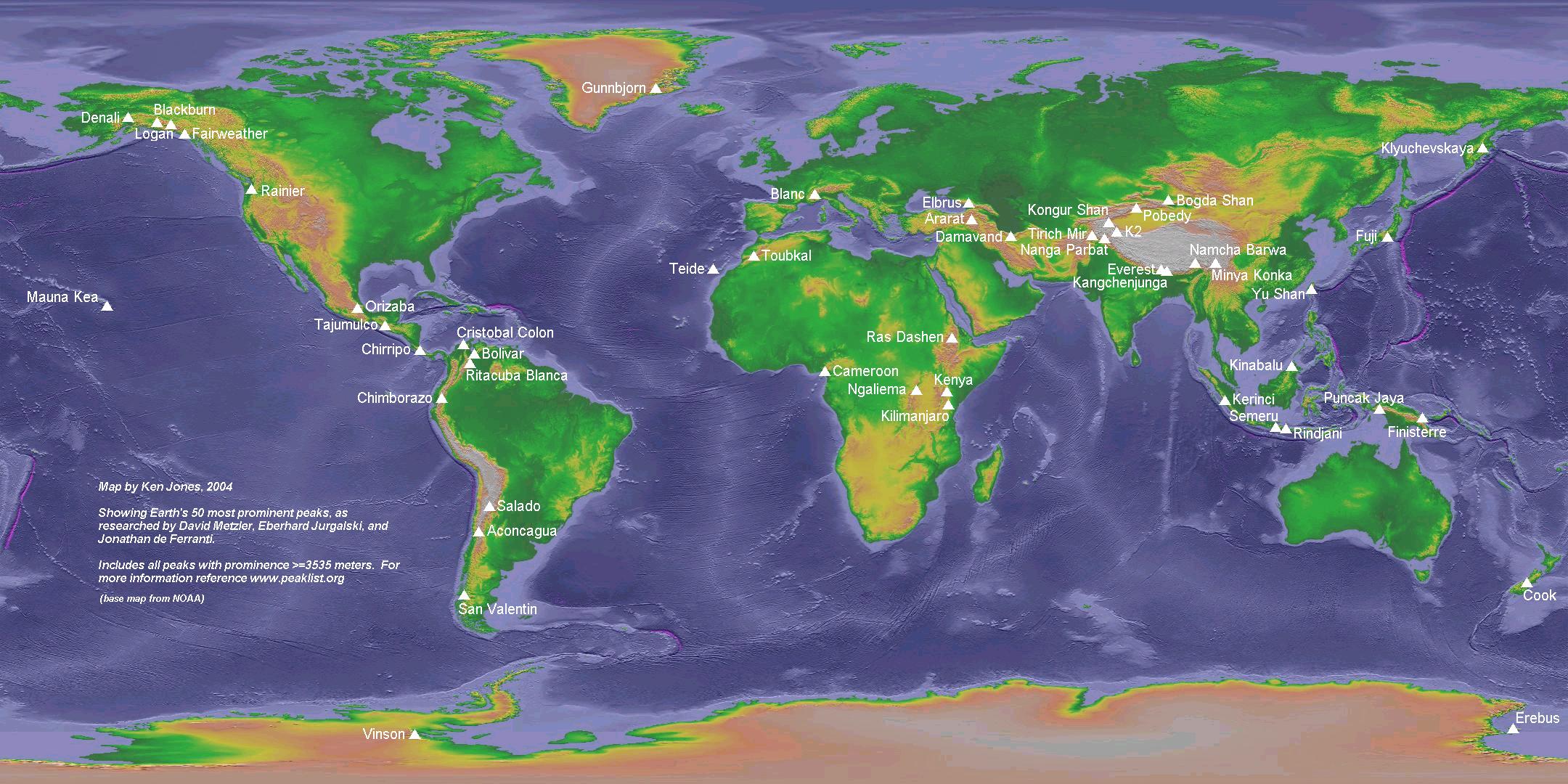
- For OR, see http://www.peaklist.org/WWlists/WorldTop50.html, and http://www.peaklist.org/WWmaps/world50.jpg
- For Mont Blanc, Topographic prominence explains, "For example, the encirclement parent of Mont Blanc, the highest peak in the Alps, is Mount Everest. Mont Blanc's key col is a piece of low ground near Lake Onega in northwestern Russia (at 113 m elevation), on the [European Watershed] between lands draining into the Baltic and Caspian Seas. This is the meeting place of two 113 m contours, one of them encircling Mont Blanc; the other contour encircles Mount Everest."
- For Orizaba, the table says the key col on the ridgeline connecting Orizaba to Logan is higher (714m) than the one between Logan and McKinley (709m).
- Likewise for Damavand, the col between Damavand and Elbrus is higher (943m) than that between Elbrus and Everest (901m).
Elbrus/Mont Blanc
Someone just removed Mont Blanc as an example of something on the topographic prominence article, because according to that editor (IP) Mont Blanc's line parent is not in teh Caucasus but "in Central Asia" (i.e. Everest, one supposes, which is what's on the list here). I'm not familiar with the lay of hte land in teh Caucasus, but if that's the case, then is Elbrus' prominence col within the Caucasus, such that Mont Blanc's "prominence line" bypasses it? If not, and Elbrus' prominence col is between the Caucasus and Afghanistan/Pamirs/Hindu Kush, then the topographic logic would say to me that Mont Blanc's parent would be Elbrus. Where are each of these peaks' prominence cols (there's nothing in the Elbrus article on prominence at all).Skookum1 (talk) 16:20, 5 September 2009 (UTC)
I think you might be confusing two different notions of "parent". The IP editor's claim was that the height parent (or NHN, nearest higher neighbor) of Mont Blanc is a central Asian peak (it wouldn't be Everest). The NHN is quite different from either the island parent or the prominence parent, and in particular, it is not the notion of parent used on this list. The IP cited Aaron Maizlish, i.e. presumably peaklist.org. I thought I remembered a discussion of the MB NHN issue there, but couldn't find it after a quick search. The issue turns on exactly where MB's key saddle is, which I think might still be unresolved. (IMHO, this is a good example of where the notion of "parent" becomes virtually meaningless.) In any case, since the claim on the topographic prominence page was sketchy, and not carefully cited, I wouldn't reinstate it at this point. -- Spireguy (talk) 19:30, 5 September 2009 (UTC)
- Peaklist.org says "The Mont Blanc key saddle has been identified in Northern Russia near Ozero Onezhskoye." (See footnote 1 on the Europe Ultras page. The fourth paragraph of the main text of that page is also interesting.) However all that tells us is that the line parent (NHN) is east of the River Volga which could be in the Caucasus or in Central Asia. —ras52 (talk) 09:26, 6 September 2009 (UTC)
- The saddle cannot be pinpointed from available topos. It could be almost anywhere along a long (100km+) stretch of the Volga-Baltic canal south east of Lake Onega which, according to the best available topos, has a constant elevation of 113 metres. Viewfinder (talk) 16:52, 6 September 2009 (UTC)
I am absolutely confused why "People's Republic of China (Tibet)" is used throughout the page. It seems that is is so important to note that a mountain is from Tibet according to a few editors. Why is it that when mountains from other regions of China (such as Xinjiang or Yunnan) are listed, they do not follow the same pattern? Why is it that when we have a peak in Argentina, we do not list the province? Smells like the stench of systematic political POV to me. Either add political subdivisions for all entries, or remove them altogether. -- 李博杰 | —Talk contribs email 09:30, 13 March 2010 (UTC)
Artificial saddles
At present, prominence researchers have accepted that saddles should be based on natural saddles, and artificial cuttings, e.g. Panama, Suez should not be taken into account. In keeping with this, I have restored the saddle of Kilimanjaro to 10m. Not all researchers have accepted this practice willingly. But for now, if you wish to challenge this practice, please continue the discussion here, rather than create inconsistencies by changing the main article. Viewfinder 16:25, 27 May 2006 (UTC)
It follows from the above the the two American continents are considered to be a single prominence landmass, with a single "island" high point. Ditto Eurasia and Africa. Viewfinder 17:00, 13 July 2006 (UTC)
The artificial saddle of the Panama Canal would reduce the saddle between Aconcagua and Denali to 25m. Now, agreed, if you ignore that, you have to go by its original elevation, and at its highest point, where it crossed the divide, was at Gaillard Cut. This elevation was originally 64m, the original de Lesseps French excavation reduced it to 59m, and it was then reduced to its current elevation of 25m (or lower if you count the depth it is dredged to, but at that point if you're going artificial you could use any of the locks themselves along the canal. I'm not sure where 56m came from unless there is some other lower point along the route, I guess is possible though not certain of it. I am not 100% certain of the original topography of the divide there before it was cut, but it was generally listed as the lowest point in the divide. It is generally known as two seperate hills today, Gold Hill and Contractor's Hill, but these are merely the remnants of what was cut across. The prominence would obviously not have been the peaks of these hills or the original hill, though. 14:33, 29 April 2010 (UTC)
Pizzo Coca at 3050 meters
A new article on Pizzo Coca was created today. Its Italian wikipedia article lists its height at 3050 meters which would put it within the top 125. I can't find a reference for this but added the info from Pizzo di Coca to our version. Could someone confirm this? --Morenooso (talk) 20:15, 11 May 2010 (UTC)
- I just visited Wikipedia:WikiProject Mountains. In their Resources section, they list the following:
- [*Peaklist.org Exhaustive lists of peaks with a minimum prominence, including all mountains in the world with > 1500 m prominence
- Pizzo Coca appears in this list under its Italian name, Pizzo di Coca, with a rank number 36 and listed at 3050 meters but its prominence is 1878 meters. I think that the prominence values disqualifies Pizzo Coca but would like another opinion. Please see:
- EUROPE ULTRA-PROMINENCES www.peaklist.org --Morenooso (talk) 20:25, 11 May 2010 (UTC)
- The world top 125 are listed in this article. Its prominence of 1878 metres puts Coca well outside the world top 125. Viewfinder (talk) 22:08, 11 May 2010 (UTC)
Mt. Blanc
Why is the Everest its parent on this website http://www.peakbagger.com/peak.aspx?pid=9941 it says its the Elbrus. I've actually even checked the Mt. Blanc wikipedia page in other languages and no mention of the parent being the Everest. Which references were used to get that information? Strumf (talk) 23:02, 14 September 2010 (UTC)
- Everest is certainly the 'encirclement parent', being the highest peak beyond the key col of Mont Blanc in northwest Russia.
- It's possible that Elbrus meets some other definition of parent. Since the Caspian Sea doesn't drain into the ocean, there are two ridgelines connecting the Alps with the Himalayas: one runs south of the Volga River and somehow through the Caucasus Mtns., the other runs north of the Volga and south somehow through the Urals and Kazakhstan. (File:Europäische Wasserscheiden.png) The latter is probably the one that counts, since the former has a low point that's probably less than 100 m above sea level, on the Volga–Don Canal. But Elbrus might be considered Mt. Blanc's 'height parent'.
- I'm not clear what territory falls into Elbrus's 'prominence parentage', "found by dividing the ... region in question into territories, by tracing the runoff from the key col of" Elbrus. That col is somewhere in W. Pakistan; the south side presumably drains into the Indus River, while the north side drains somehow into the Caspian or Aral Sea. I don't know where that leaves Europe. I suppose the notional drainage of the Caspian is into the Atlantic via the Don River, Black and Mediterranean Sea. That would leave everything west of the lower Don, including Mt. Blanc, in Everest's territory.
- Peakbagger is using different definitions than our topographic prominence article. What he calls 'Line Parent', "defined as the closest higher peak to a given summit, following ridgelines past the key col", is what we call 'height parent'. What he calls 'Prominence Parent' is what we call 'encirclement (or island) parent'.
Untitled
http://www.peaklist.org/WWlists/ultras/EuroCoreP1500m.html 22 Parîngul Mare Romania 2519 2103 416 45º20'28"N 23º32'26"E 8264 6900 [22] 23 Monte Viso Italy 3841 2062 1779 44º40'03"N 7º05'27"E 12602 6765 24 Triglav Slovenia 2864 2052 812 46º22'41"N 13º50'13"E 9396 6732 25 Varful Moldoveanu Romania 2544 2046 498 45º36'00"N 24º44'16"E 8346 671 — Preceding unsigned comment added by Zenhabit (talk • contribs) 13:13, 4 September 2011 (UTC)
Mt. Shasta
The prominence for Mt. Shasta listed in the table (2977 m) does not agree with the article about Mt. Shasta (2994 m). — Preceding unsigned comment added by 71.56.157.70 (talk) 02:00, 8 August 2012 (UTC)
Better illustrations
Appropriate illustrations would be a lot of help at points. For example, I'm having trouble making sense of North America; it seems like there could be a map with various lines, one showing the area in which everything considers McKinley an ancestor, and then a line showing the area in which everything considers Logan an ancestor (and thus nothing considers McKinley a direct parent) and then Orizaba, and so on. At least a map with the peaks on it would help visualize it.--Prosfilaes (talk) 08:56, 24 August 2013 (UTC)
Parentage of Ismoil Somoni Peak
This article says that the prominence parent of Ismoil Somoni Peak is K2 and its encirclement parent is Mount Everest. This contradicts List of highest mountains, which says that Ismoil Somoni Peak's line parent is Muztagh Ata and Muztagh Ata's line parent is Kongur Tagh, which would mean that Ismoil Somoni Peak's prominence parent and encirclement parent is Kongur Tagh. Lophotrochozoa (talk) 12:26, 24 March 2015 (UTC)
Just by seeing the title I was not completely clear of the subject and I wondered if it should be clarified. GregKaye 18:17, 22 April 2015 (UTC)
WATCH THE ARTICLE!
IMHO: There's not much point in various editors compiling the list, and in Wikipedia in general, if someone comes and makes modifications like these, which remain unchallenged. — Preceding unsigned comment added by 5.12.161.66 (talk) 01:23, 25 June 2015 (UTC)
Joley?
Joley is defined as a column header with a link to Mountain Pass but is not really defined in this article or even present at the linked article. Google searches for the word also do not currently return this use of the word in the first page of results. The term needs better support. Vttale (talk) 16:45, 12 May 2016 (UTC)
Sub-national areas
Various sub-national areas had been included for the purposes of describing the location better. This seems to given many editors the urge to include a sub-national area for all of the peaks. I have reduced to the sub-national areas to the following
- Alaska - non-contiguous with the rest of US
- Hawaii - island non-contiguous with the rest of US
- Taiwan - controversial island
- Réunion - island non-contiguous with European France
- South Georgia - island non-contiguous with UK
If there are any other sub-national areas that editors feel need to be included, please provide justification.Jameel the Saluki (talk) 09:53, 20 January 2017 (UTC)
Kilimanjaro - Child of Everest!?
I read the article, and then the talk page, and then read a separate article about Afro-Eurasia being technically a supercontinent and thus all one landmass etc, but... no, I still can't shake off my abiding initial impression that some of these "prominent parent" associations are just plain silly. To link Kilimanjaro and Everest is to stretch concepts of "linked territory" paper-thin, IMHO. If I were to insist that "Mt Everest is the parent of Mt Kilimanjaro" to friends down the pub, there'd soon be an argument and then a fist fight! They're not even the same species of lump (one's a stratovolcano, t'other's a stratified mountain - different animal altogether, my mates would say). No, those into prominent peaks should get out more often - or take another peek, as they can't see the wood for the trees! From 1869 until 1983 you couldn't walk from Africa to Asia without getting your feet wet (in salty water) and even now you probably can't walk the Suez Road Bridge or the tunnel without permission. Who'd want to walk it all that distance anyway - to prove a concept? No, it's all a step too far... even for a step-parent of Kilimanjaro.. The African continental plate is colliding slowly with the Eurasian plate, but the sea level's rising. These two continents ain't never nohow gonna be one landmass! Pete Hobbs (talk) 18:06, 11 October 2011 (UTC)
- You are not alone in your sceptical view, but by the well established mathematical definition of prominence parent, Everest is Kilimanjaro's parent. You should take your case to the topographic prominence discussion page, as it applies to the whole concept of prominence parent, not just Afro-Eurasia. Viewfinder (talk) 00:56, 12 October 2011 (UTC)
- I'd say that this would still be the appropriate place to discuss this, as the main question is: what do the sources say and why? And I would say that it's really only an Afro-Eurasia issue, as I believe there is no other case in the world where two landmasses of any significant size have been sundered by a sea-level canal. Nonetheless, as Pete took did bring it up there, I've elaborated my objections there as well. Just putting it on record here. —Quintucket (talk) 02:32, 16 April 2012 (UTC)
- The fact remains that Everest is Kilimanjaro's parent, via the land bridge connecting Africa to Eurasia, even if some editors cannot grasp that fact. The Suez canal is an artificial breach and therefore does not count. If we do not accept the current version, we have to redefine prominence parentage with a completely new definition, or delete the parentage column and concept in its entirety. Viewfinder (talk) 12:02, 21 October 2012 (UTC)
- Agree with all you said VF. Including the notion that maybe we should delete the parentage stuff. This has been in the back of mind for a while. It's a concept that is counter-intuitive, difficult to grasp and is one more thing that gets needlessly challenged—shot down by the same handful of editors—and then challenged again. --RacerX11 Talk to meStalk me 12:25, 21 October 2012 (UTC)
- The concept of Kilimanjaro being a child of Everest does not bother me at all. Personally I don't see it as counter-intuitive, and and I see no satisfactory alternative definitions of prominence parentage. If we delete the parentage stuff, we will have to delete it from hundreds or even thousands of articles. It is well established and it has been fairly stable, and I don't think the case for deletion has been made, but if the occasional challenges are tips of much larger icebergs, then the issue needs to be discussed further at Talk:Topographic prominence. Viewfinder (talk) 13:21, 21 October 2012 (UTC)
- Yes, if we think the parentage column should go, it should be discussed first as you say. Allow me to back-pedal a little: I want parentage of the peaks to remain in the articles. I think part of the problem is the parentage data appears unsourced. Can we directly source the parent column at this page with an inline cite? --RacerX11 Talk to meStalk me 13:33, 21 October 2012 (UTC)
- Ultimately, inline citations have to lead to external sources. There is long list of external links at Topographic prominence. This one sounds the best to me, but you might like to check out some of the others too. Viewfinder (talk) 14:26, 21 October 2012 (UTC)
- I will try to be more direct to the crux of the problem as I see it. If another editor changes the parentage of a peak to some other plausible sounding peak, how do I know if that edit is correct or not? If I find a mountain article that gives a parent that's different from that indicated on this list, how do I know which is correct? I do not have access to the world's topographic maps. I thought I found somewhere a while back a website where I can verify parentage, but I can't remember where or what is was now. The link you provide has great info on the general theory. I want a link to something that states Peak A's parent is Peak B, if such a thing exists. If not, then the parent column is OR. Is is not? --RacerX11 Talk to meStalk me 14:45, 21 October 2012 (UTC)
- Just wanted to add that I am on your side here. I have a great deal of respect for you and your value on Wikipedia. You have helped me several times and I do not want to make your life difficult. It is obvious you have access to large amounts of detailed data. I am interested in this knowledge you have only so I can help you maintain these articles. Is this OK? Am I treading on sensitive ground with you for reasons I am unaware? --RacerX11 Talk to meStalk me 15:02, 21 October 2012 (UTC)
- Re sensitive ground: absolutely not. I have never encountered an edit from you that has been anything other than helpful. Viewfinder (talk) 15:16, 21 October 2012 (UTC)
- Re your specific point about OR. The Peaklist site covers parentage theory but does not include the specific parentage claims listed on this page. I think these were added some time ago by User:Mark_J, using this source, which is included among the sources listed here. I was not the author of that list, but I contributed to it and it is on my site. The author, Eberhard Jurgalski, has been a prominence researcher for more than 20 years, and Mark J's grasp of parentage is excellent. They evidently accepted, for example, that Everest is Mont Blanc's parent. So although I may have been the ultimate source of the MB/Everest claim, I would defend myself against any OR charges with claims that the my claim has been properly peer reviewed. As for the claim by a new editor that Elbrus is Ararat's parent, well that is OR. Viewfinder (talk) 15:36, 21 October 2012 (UTC)
- Ok, I see it now. It is the link Go to World Top 100 Table just for future reference. That's the one I saw a while back! I just wasn't looking closely enough when I clicked on it this morning. My bad. Thank you! --RacerX11 Talk to meStalk me 16:28, 21 October 2012 (UTC)
- Evidently you started your edit to my talk page before I posted my response to your OR concern, i.e. our edits crossed. This often happens. Viewfinder (talk) 17:47, 21 October 2012 (UTC)
I suggest that someone include a definition/ explanation of the definition of "prominece parent." On the wiki somewhere in the footnotes or something to prevent futher confusions.AI coolTIM (talk) 03:22, 12 June 2017 (UTC)
Mt. Ashland in Oregon, USA
Mount Ashland has a prominence of 3,132 feet, with its elevation of 7,533 feet. https://en.wikipedia.org/wiki/Mount_Ashland
Why is it not on our list guys? Was the entire ranking list automatically generated or manually created? — Preceding unsigned comment added by Dgfduck (talk • contribs) 23:40, 19 January 2018 (UTC)
- I think you are getting your feet and metres confused. 3132 feet is less than 1000 metres so Ashland is nowhere near qualifying for the main list. Heaven forbid that the additional list should become one to which we are all free to add our own local favorites. Viewfinder (talk) 04:46, 21 January 2018 (UTC)
Mt. Everest
Why is the prominence of Mount Everest listed as its summit's elevation? I don't believe its base drops directly to sea level, does it? :) Shannontalk contribs 03:14, 1 January 2010 (UTC)
this^^^
The whole table is a joke, Denali is the most prominent peak in the world. Everest sits atop the Tibetan plateau which has an elevation of around 4500m — Preceding unsigned comment added by 96.54.181.40 (talk) 23:11, 21 April 2014 (UTC)
- Topographic prominence stated in its article and for the purposes of this list, has a strict definition that differs from most people's intuitive expectation of what "prominence" should mean. In this list, prominence = elevation above sea level - key col.
- Regarding Everest's height in relation to the Tibetan Plateau — that has more to do with the concept of local relief, which is a far more subjective measurement. There is also the related concept of spire height which also has a degree of subjectivity in it.
- To further complicate all this, some of the equivalent definitions and visualizations for prominence do not work for Everest, precisely because it is the highest point on Earth. So we have a special prominence definition just for Everest: Its prominence equals its elevation above sea level. This special definition is consistent with other landmass high points, which by the standard definition, have their key cols at sea level. Hope this helps. --RacerX11 Talk to meStalk me 00:53, 22 April 2014 (UTC)
- One of the 'equivalent definitions' of prominence does give us a value for the prominence of Everest: "elevation of the summit above the lowest contour that encircles that summit but no higher one". The coastline of the whole of Afro-Eurasia is a sea-level contour, just as all ocean coastlines are, and it certainly encircles Everest, but also doesn't contain any point higher than the summit of Everest (because of course there aren't any), hence Everest's prominence is its elevation above sea level; we get the same result about the prominence of any summit that's the highest on its landmass. — Preceding unsigned comment added by Adam Dent (talk • contribs) 10:20, 3 September 2018 (UTC)
Easy way to understand Prominence
Since so many seem to be confused.
1. If highest peak on a landmass, then it is the elevation. 2. For every peak not the highest elevation on a landmass, raise sea level until the sea cuts off a given peak from any higher peak on the same landmass. 3. Once this is achieved, subtract the amount you had to raise the sea from the elevation of your peak.
Simple, no?Aapold (talk) 14:44, 29 April 2010 (UTC)
Correction: 1. If the peak in question is the highest peak on its landmass, then its prominence equals its elevation. 2. If the peak in question is not the highest elevation on its landmass, raise sea level until the sea cuts off the given peak from any higher peak on the same landmass.
The prominence of the given peak is the elevation of the given peak minus the amount you had to raise the sea.
162.207.203.26 (talk) 04:23, 11 October 2018 (UTC)
Additional Peaks section
I am restoring this section as no reason was given why it is uncyclopedic, and the prominennce of some of the well known peaks that do not make the table (e.g. Eiger, Matterhorn) is of interest. Viewfinder (talk) 23:30, 7 November 2019 (UTC)
Dead Sea should be the base for counting prominence
I don't understand why prominence is counted with respect to the sea level. The Dead Sea is -427 m below sea level and is the lowest place on the Earth. Just picture that the oceans are lowlands and the Dead Sea is an even lower lowland. The real prominence of Mt. Everest is 9,275 m. It doesn't matter, if Dead Sea is a tiny area. Ideas have to be driven even ad absurdum, if we want to sea, whether our theory is valid. 85.70.117.103 (talk) 09:45, 28 June 2014 (UTC)
- If Mount Everest were on an island surrounded by the Dead Sea on all sides then its prominence would be 9275. As it is, it is the HP of the Eurasia-Africa landmass, which is surrounded on all sides by the sea to which convention has assigned an elevation of 0. Therefore its prominence is equal to its height ASL. Viewfinder (talk) 01:04, 29 June 2014 (UTC)
- Oh yes, you are totally right. The mountain has to be fully surrounded by a contour line. Thanks. 85.70.117.103 (talk) 21:02, 29 June 2014 (UTC)
- Note however that the Earth has spherical topology, therefore if you draw the contour around the Dead Sea and define the waters of the Dead Sea as "outside", then this contour 'encircles' the rest of the planet including Everest. ;-) Oddly enough, the dry prominence of Everest, as currently explained, uses the Challenger Deep as a baseline so it follows this kind of convention. --Nanite (talk) 05:05, 2 July 2020 (UTC)
First item in table evidently not authentic
I think someone needs to fix the table, entry no.1 has been either modified or compromised. — Preceding unsigned comment added by 2001:558:6026:54:3873:4ECC:2EBA:727C (talk) 03:26, 24 February 2021 (UTC)
Prominence Parent and Encirclement Parent rows appear to be offset from Peaks by 1 row
Hi, The data in the Prominence Parent and Encirclement Parent rows appear to be offset from the data in the other columns by 1 row (My first Wikipedia post - sorry if I have strayed from etiquette.) UbuTranscendent (talk) 23:32, 9 March 2021 (UTC)
- Thanks for trying to help! It would not be surprising, because tables often get messed up one way or another. But it doesn't seem to be so in this case: the first two entries (Everest and Aconcagua) are high points of pieces of land surrounded by water, and the next is Denali, whose parent is Aconcagua. How did you think it was wrong? Imaginatorium (talk) 05:37, 10 March 2021 (UTC)
Parent Peaks
Unless I completely misunderstand what parent peaks are, the columns in the prominence table must be off. For example, Denali's parent peak is listed as Aconcagua even though they are on completely different continents. Columns beneath this also have the same issue. FourTildes (talk) 15:08, 19 August 2018 (UTC)
- You do completely misunderstand. This is about topography, in which the basic notions are of a contiguous piece of land surrounded by water. "Continent" is an odd term, being a mishmash of politics and traditional geography. North and South America form a single piece of land, as do Africa, Europe and Asia. (The boundary between Europe and Asia is completely political, which is why it keeps moving.) Imaginatorium (talk) 04:09, 5 November 2018 (UTC)
It would be helpful if an expert could add a footnote to explain which definition of "parent" the main table uses. The link from the heading leads to an interesting discussion of several alternatives but does not clarify which one is in use here. Perhaps multiple definitions are in use, as several peaks have two parents. Certes (talk) 14:02, 12 June 2019 (UTC)
- I'm not an expert, and have extreme difficulty grocking the prominence parent definition. But there is a note at the top of the table saying the two types, where different, are identified by superscripts 1 and 2. But they aren't. It's probably fairly easy to spot which is which though. Imaginatorium (talk) 19:25, 12 June 2019 (UTC)
I'm not an expert, either, but I think the Lists of John website is considered pretty definitive by experts, and it lists Denali's line parent as Chimborazo in Ecuador. Also in South America, but as the previous poster pointed out, that is irrelevant in the case of every continent except Australia and Antarctica. The formal definition of line prominence, I think, is the distance between the summit and lowest contour line on land that surrounds the peak and does not surround anything higher. I am going to edit the page and replace Aconcagua with Chimborazo and hope I don't create a huge controversy. AlexFeldman (talk) 11:30, 29 August 2021 (UTC)