
User:Kew Gardens 613/List of unopened subway entrances
Previously unopened entrances[edit]
| Station | Division | Line | Borough | Location | Date Station Opened | Date Opened | Reason for Opening |
|---|---|---|---|---|---|---|---|
| Bergen Street | B (IND) | Culver Line | Brooklyn | Warren Street and Smith Street | March 20, 1933 | After 1940[1] | Did not open along with the other Warren Street entrances in 1933,[2] and still closed in 1940.[3] The Butler Club requested the opening of the entrances in 1949.[4] |
| Fort Hamilton Parkway | Brooklyn | Southeastern corner of Reeve Place and Prospect Avenue | October 7, 1933 | ||||
| Northwestern corner of Fort Hamilton Parkway and Prospect Expressway | October 1962 | Entrance did not open with the rest of the station.[5] Was partially demolished as part of the construction of the Prospect Expressway. It was decided to rebuild it and open it following a TA poll that found that 73% of nearby residents questioned favored opening the entrance.[6] The survey, which was issued in March 1962, was done at the request of local residents who claimed that the opening of the highway made the opening of the entrance necessary.[7] | |||||
| Franklin Avenue | B (IND) | Fulton Street Line | Brooklyn | Eastern corners of Classon Avenue and Fulton Street (2) | April 9, 1936 | ||
| Greenpoint Avenue | B (IND) | Crosstown Line | Brooklyn | Southern corners of India Street and Manhattan Avenue | August 19, 1933 | By August 25, 1933[8] | The NYCBOT did not believe that ridership would warrant hiring people to staff the entrances.[9] |
| Nassau Avenue | Northern corners of Norman Avenue and Manhattan Avenue | August 1936[10]—1941[11][12] | |||||
| Nostrand Avenue | B (IND) | Fulton Street Line | Brooklyn | Mezzanine to both eastern corners of Bedford Avenue and Fulton Street (2)[13][14][15] | April 9, 1936 | 1950 | The entrances were boarded up, and were only opened after a fight by the Bedford-Stuyvesant Neighborhood Council. After the decision to open it was announced, turnstiles and a change booth were installed in the entrance.[16] |
| Utica Avenue | Western corners of Stuyvesant Avenue and Fulton Street | c. June 1936[17] | The opening of the entrances was urged by the Fulton-Macon Civic Association, which sent a petition to Chairman of the Board of Transportation, John Delaney. He ordered that the entrances be reopened in June 1936. | ||||
| 47th–50th Streets–Rockefeller Center | B (IND) | Sixth Avenue Line | Manhattan | Southwestern corner of 47th Street and Sixth Avenue (1) | December 15, 1940 | After 1941 | The entrances was fenced up since the line's opening[18] |
| 46th Street | B (IND) | Queens Boulevard Line | Queens | Northeastern corner of Newtown Road and 48th Street (1) | August 19, 1933 | After January 1934[19] | The Astoria Heights Taxpayers Association circulated petitions in October 1933 demanding that these entrances be opened.[20] |
| Southeastern corner of 48th Street and Broadway (1) | |||||||
| 63rd Drive–Rego Park station | 63rd Drive and Queens Boulevard (1) | December 31, 1936 | March 15, 1943 | The entrance was opened after a four-year effort by the Rego Park Democratic Club demanding its opening. Superintendent of the IND had said that the cost of maintaining a change booth was unwarranted, and said that the turnstiles in use at unstaffed entrances were frequently jammed with slugs. It was to be open from 7 a.m. to 7 p.m. daily as an exit only. A checker would be stationed at the exit to determine whether the hours should be extended. The club had submitted petitions with 5,428 signatures asking to have the staircase opened and used for exits and entrances. There would be two exit turnstiles. The entrance had been boarded up since the line opened. The entrance would provide direct access to a bus stop, and would help riders boarding in the front half of trains heading Queens-bound.[21] | |||
| 67th Avenue | Eastern corners of 67th Drive and Queens Boulevard (2) | February 5, 1962 | This entrance has been built along with the rest of the station, but had not been opened until this point because the station's ridership had not warranted it.[22] The reopening was also prompted by action from civic organizations. The change booth would be open from 6 a.m. to 9:30 p.m. Monday to Friday.[23] | ||||
| 75th Avenue | Southeastern corner of 75th Road and Queens Boulevard (1) | July to October 1938 | This entrance opened due to increased ridership from six new apartment buildings in the area.[24] The owners of these six new apartment buildings, Cord Meyer Development Company, local homeowners and civic associations placed pressure on the Board of Transportation to open the entrance in June and July 1938.[25][26] | ||||
| Queens Plaza | Bridge Plaza[27] | August 19, 1933 | After August 1933 | ||||
| Steinway Street | Northeastern and southwestern corners of 34th Avenue and Steinway Street (1) | After January 1934[19] | The Astoria Heights Taxpayers Association circulated petitions in October 1933 demanding that these entrances be opened.[20] | ||||
| Woodhaven Boulevard | Northeastern corner of 92nd Street and Queens Boulevard | December 31, 1936 | After December 1938 | The opening of the entrance was urged by the Elmhurst, Queens, Community Council. The group threatened to "go down and open it up themselves" if the Board of Transportation did not do so.[28] |
Unfinished or unopened entrances[edit]
BMT[edit]
- Broad Street - unbuilt passageway and easement entrance inside the Radio Corporation Building, 64 Broad Street, on west side of Broad Street between Exchange Place and Beaver Street[29]: F-502
- Rector Street - provision at south end of uptown platform to Exchange Alley on east side of Trinity Place[30][31][32]: 626 [33]
- 36th Street - never-opened entrances at southern corners of 36th Street and 4th Avenue
IRT[edit]
- 103rd Street - possible provisions for entrances to 104th Street and Lexington Avenue[34]
- Street stair numbering at this station jumps from S1 to S4, with nowhere else in the existing mezzanine to add two street stairs
- 104th Street is toward the northern third of the platforms, similar to the 111th Street entrances at 110th Street, a station with similar design
- Sewer lines run adjacent to the bottom of both platforms' sidewalls; these likely prevented the entrances' construction
- Elder Avenue - provisions for entrances at the northwest and southeast corners of Elder Avenue and Westchester Avenue.[35]
- Lexington Avenue/51st Street - provisions for a second stairway from the GE Building, further to the west on 51st Street.[36][37]
- Nevins Street - unopened entrance at northeast corner of Fulton Street and Flatbush Avenue[38]
- Accessed through a long passageway and lower level underpass from both platforms[39]
- Likely intended as a transfer to the Fulton St elevated
- Pennsylvania Avenue - provisions for entrances at Georgia Avenue and Livonia Avenue. Has the same structural girders for an unbuilt mezzanine as Saratoga Avenue.
- Saratoga Avenue - provisions for entrances at Grafton Street and Livonia Avenue - formally referenced as “structural girders of an unbuilt mezzanine”[40]
- Van Siclen Avenue - provisions for entrances at Bradford Street and Livonia Avenue
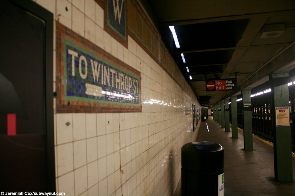
- Winthrop Street - former/demolished exit or provision at north end of uptown platform to Winthrop Street on west side of Nostrand Avenue[41][42][43]
IND[edit]
- Northern Boulevard - provision for entrance to southeastern corner of 54th Street and Broadway[44]: F-505
- Steinway Street - provision for easement entrances to southeastern corner of 34th Avenue and Steinway Street.[45]
- Two short passageways, one to Steinway Street and another to 34th Avenue, were proposed to branch off the existing unfinished stair. Contract drawings state that "This stairway subject to change or omission".[46]: F-536, F-538
- Space of unfinished stair used by Station Department.
- 75th Avenue - provision for entrance to north side of Queens Boulevard at 75th Road, east of 112th Street[47][48] in an easement to the Medical Center building,[49] space used by Division of Stations; entrance removed, opening urged in March 1941[50][51]
- Bedford–Nostrand Avenues - Provision for a future mid-block exit on the north side of Lafayette Avenue west of the stair to Nostrand Avenue at the northeastern corner of the widened mezzanine area[52]: F-524, F-535
- Broadway
- Flushing Avenue[55]: 2602 [56]
- Provision at middle of platforms for entrances to Wallabout Street and Union Avenue[57]
- Northbound provision used as a Structural Storage Room
- Southbound provision used as a Store Room
- Provisions at existing control areas for additional street stairs[52]: F-552
- Northwest corner of Flushing Avenue and Marcy Avenue
- Southeast corner of Flushing Avenue and Marcy Avenue
- Southeast corner of Walton Street and Union Avenue, stair S4
- Easement stair, partially built and blocked by wooden bulkhead
- Provision at middle of platforms for entrances to Wallabout Street and Union Avenue[57]
- Fort Hamilton Parkway - never-opened exit to west side of Prospect Avenue at Reeve Place[58]
- The entrance did not open with the rest of the station, and was blocked at the mezzanine level with a wire mesh fence.[59]: F-528
- The property owner of 1246 Prospect Avenue filed a suit, claiming the entrance obstructed access to their property; the suit was scheduled to be tried on January 20, 1936.
- A Board of Transportation report deemed the entrance to be not be needed for a considerable period of time; the stair was closed and slabbed over and its entrance structure was removed.
- The report stated that the entrance could be reopened at its former location with the consent of the owner, or at the curb line without owner's consent when "traffic warrants reopening."[60]
- Greenpoint Avenue
- Provisions at middle of platforms for entrances to southern corners of Java Street and Manhattan Avenue. Northbound side used for a Structures Room; Southbound side used by Station Department[61][55]: 2590 [57][62]: F-516
- Provision at south end of mezzanine (control area N405) for short passageway to stair northeast corner of Greenpoint Avenue and Manhattan Avenue[63][62]: F-517
- Based on station drawings, the new stair would have been labeled S4 and the currently mislabeled S4/P6 stair would have likely been relabeled S6/P6 based on geographical order
- Kew Gardens—Union Turnpike - provisions at Northwestern corner of Queens Boulevard and Union Turnpike[64][48]
- Accessed through passage for car drop-off zone on west side of Union Turnpike underneath Queens Boulevard[65]: 151
- On June 23, 1936, the contractor was ordered to remove the structure provided for this stairway, to construct a wall across the opening to the entrance, and install a granite facing on this wall. The contractor was ordered to remove the concrete slab from the stairway at 78th Avenue and to complete it.[66]
- Myrtle–Willoughby Avenues[67][68][69]
- Provisions at middle of platforms for entrances at all four corners of Vernon Avenue and Marcy Avenue[52]: F-542
- Northbound provision used as a communications room
- Southbound provision used as a Station Department room
- Provisions at existing control areas for additional street stairs[52]: F-542
- Southeast corner of Marcy Avenue and Myrtle Avenue
- Northeast corner of Marcy Avenue and Willoughby Avenue
- Southwest corner of Marcy Avenue and Willoughby Avenue
- Provisions at middle of platforms for entrances at all four corners of Vernon Avenue and Marcy Avenue[52]: F-542
- High Street - never-opened exit to southeastern corner of Cadman Plaza East (originally Washington Street) and Red Cross Place[70][71][72]
- Nostrand Avenue — never-opened exit to the northern corners of Arlington Place and Fulton Street, stairs S5 and S6.[73][55]: 1235 [69]
- 14th Street/Eighth Avenue - unbuilt easement entrance on east side of Eighth Avenue, north of Greenwich Avenue[76]: F-502, F-503
- Accessed by an unopened passageway
- 34th Street–Penn Station - unbuilt easement entrance to 594 8th Avenue at southeastern corner of 35th Street and Eighth Avenue[76]: F-538, F-544
- 42nd Street—Bryant Park - unbuilt entrances mid-block on north side of 42nd Street between Broadway and Sixth Avenue
- Original 2004 plans for the 42nd Street shuttle’s reconstruction called for an easement entrance on the south side of One Bryant Park in a pedestrian plaza, accessing a passageway connecting the west end of the Times Square shuttle platform with the northern mezzanine of the Bryant Park IND station.[77]
- Later 2019 plans called for a longer shuttle platform shifted to the east, shortening the passageway, replacing the easement entrance with two sidewalk stairs, and shifting the access point to the east end of the shuttle platform.[78]
- In 2021, the sidewalk stairs and the underpass to the shuttle platform were entirely removed from plans. The transfer to the IND station was moved to a passageway extending from the shuttle platform.[79]
- A red and white globe still marks the location of the easement entrance despite the latter never opening.[80]
- 59th Street—Columbus Circle
- Future passageway to just north of the northeastern corner of Central Park South and Columbus Circle from the north central mezzanine[81]: F-530
- likely never-opened easement exit and passageway to the southwestern corner of 61st Street and Central Park West into the Circle Building and to a stairway outside the building. Was to be a switchback staircase. The developer, Veronica Realty, reached an agreement with the Board of Transportation for the passageway, entrance, and to have a show-window installed into the passageway.[82][83]: 320, 325 [84][81]: F-532
- 72nd Street - provision for entrance door to basement of The Majestic apartment building[81]: F-571
- 103rd Street - provisions for easement entrances[85]: F-549
- Southwestern corner of 102nd Street and Central Park West - entrance into apartment building
- Northwestern corner of 103rd Street and Central Park West - entrance and shop window into building
- Southwestern corner of 104th Street and Central Park West - entrance and shop window into building
- Canal Street - provision for easement entrance at southeastern corner of Canal Street and Sixth Avenue[86]: F-539
- Second Avenue
- Seventh Avenue–53rd Street - never-opened exit under substation at 126 53rd Street (just east of 6½ Avenue), stair S1, control area N302.[37][88][61][89][90] Spaced used for Transformer Closet, Circuit Breaker House
- Opening recommended in an 1985 study by the New York City Department of City Planning to reduce crowding at Fifth Avenue/53rd Street station.[89]
- Spring Street - never-opened easement entrance at the northwestern corner of Vandam Street and Sixth Avenue, Stair S5 (1)[91]
- The stairways were barricaded shortly after the opening of the subway, a masonry wall was erected at the building line, and the walls were backfilled.[92]
- In 1937, the easement was released to the Board of Transportation for the construction of a money collection building. That plan was abandoned, and, in 1948, the Chairman of the Board of Transportation surrendered the easement as no longer needed for rapid transit purposes.[93]
- The property owner, Nessler Properties,[94] in 1962, requested the release of the stairway easement as part of its plan to construct a 16-story apartment building on the site.[92]
- Currently used for storage.
- West Fourth Street–Washington Square
- Southeastern corner of Washington Place and Sixth Avenue to lower mezzanine, Stair S5.[91][55]: 1196
- Space partially occupied by police room. The portion of the mezzanine in front of the entrance is used by the Structure D Night Force.[95] Entrance partially constructed along with the station, but never opened.
- A small shed at street level had protected the entrance, which included a stairwell and an unused escalator well. In 1952, the property above the entrance easement was sold, along with the easement, with the understanding that the owner would provide a concrete slab to protect the entrance.[96]
- Passageway to Ninth Street PATH station
- A fare array situated at the north end of the mezzanine, in front of the unfinished passageway, was shown as barricaded by a chain linked fence at the time of the station's opening.[86]: F-582
- The passageway connected to the existing entrance to the Ninth Street station and contained two additional PATH entrances on opposite sides of Sixth Avenue[86]: F-501 , one of which was discovered by a local resident.[97]
- It is unclear if the passage ever opened, or if it was ever completed.
- Southeastern corner of Washington Place and Sixth Avenue to lower mezzanine, Stair S5.[91][55]: 1196
- York Street - provisions in ceiling for entrance to Sands Street and Jay Street[98]
- At two structural bays along the platform, there are spaces in the ceiling and columns are spaced 17.5 feet apart, instead of the usual 15 feet.
- Provisions are considered appropriate for addition of a second entrance to the station.
Provision for second staircase at the same corner[edit]
Many IND stations in the 1930s were designed with double-width stairs from the mezzanine level leading to an intermediate landing, with provisions for a second street stair from this landing.[99]
- East Broadway - Southeastern corner of East Broadway and Rutgers Street[100]: F-569
- Kew Gardens–Union Turnpike – Southeastern corner of 80th Road and Kew Gardens Road
- Northern Boulevard - Northwestern corner of 54th Street and Northern Boulevard[44]: F-505
- Spring Street[86]: F-565
- Northwestern corner of Charlton Street and Sixth Avenue
- Southeastern corner of Prince Street and MacDougal Street
References[edit]
- ^ "Jubilee Celebration Opens October 4". The Brooklyn Tablet. July 29, 1933. Retrieved December 6, 2020.
{{cite news}}: CS1 maint: url-status (link) - ^ "City's Subway Open March 20 to Bergen St". The Brooklyn Daily Eagle. March 12, 1933. Retrieved May 24, 2022.
- ^
- "187 Smith Street". New York City Department of Records and Informational Services. New York City Department of Finance. 1939–1941. Retrieved September 19, 2021.
{{cite web}}: CS1 maint: date format (link) - "180 Smith Street". New York City Department of Records and Informational Services. New York City Department of Finance. 1939–1941. Retrieved September 19, 2021.
{{cite web}}: CS1 maint: date format (link)
- "187 Smith Street". New York City Department of Records and Informational Services. New York City Department of Finance. 1939–1941. Retrieved September 19, 2021.
- ^ "Wants Unused Tube Entrance Opened". The Brooklyn Daily Eagle. July 25, 1949. Retrieved May 24, 2022.
- ^ "Traffic Lagging So City Delays Subway Finish". New York Daily News. April 9, 1935. Retrieved May 24, 2022.
- ^ "Builder Nearing Completion of IND Entrance" (PDF). New York World-Telegram and The Sun. September 10, 1962. Retrieved December 6, 2020.
{{cite news}}: CS1 maint: url-status (link) - ^ "For Immediate Release: Tuesday, March 13, 1962 #246". Flickr. New York City Transit Authority. March 13, 1962. Retrieved December 6, 2020.
{{cite web}}: CS1 maint: url-status (link) - ^ "Subway Now in Full Swing; Thousands Watch Parade and Took Part in Opening". Greenpoint Weekly Star. August 25, 1933. Retrieved May 24, 2022.
- ^ "7 Entrances to Local Tube" (PDF). Greenpoint Weekly Star. August 18, 1933. Retrieved May 24, 2022.
- ^ "McGuinness Battles For Subway Entrance". New York Daily News. August 2, 1936. Retrieved December 6, 2020.
{{cite news}}: CS1 maint: url-status (link) - ^ "700 Manhattan Avenue". New York City Department of Records and Informational Services. New York City Department of Finance. 1939–1941. Retrieved February 28, 2022.
{{cite web}}: CS1 maint: date format (link) - ^ "699 Manhattan Avenue". New York City Department of Records and Informational Services. New York City Department of Finance. 1939–1941. Retrieved February 28, 2022.
{{cite web}}: CS1 maint: date format (link) - ^ "1241-43 Bedford Avenue". New York City Department of Records and Informational Services. New York City Department of Finance. 1983–1988. Retrieved September 17, 2021.
{{cite web}}: CS1 maint: date format (link) CS1 maint: url-status (link) - ^ "1245-51 Bedford Avenue". New York City Department of Records and Informational Services. New York City Department of Finance. 1983–1988. Retrieved September 17, 2021.
{{cite web}}: CS1 maint: date format (link) CS1 maint: url-status (link) - ^ "Google Maps". Google Maps. Retrieved July 7, 2019.
- ^ "Free Transfers, New Subway Exit Won for Bedford". The Brooklyn Daily Eagle. June 16, 1950. Retrieved February 21, 2019.
- ^ "Tube Entrance Opening Due, Fulton Civics Told". Brooklyn Times Union. June 11, 1936. Retrieved December 6, 2020.
{{cite news}}: CS1 maint: url-status (link) - ^ Hacker, Emory (February 27, 1941). "Sixth Ave. Bottleneck—47th St. Exit Brings Complaint" (PDF). New York Post.
- ^ a b "Astoria Drives For Open Doors to Subway Line". New York Daily News. January 7, 1934. Retrieved May 24, 2022.
- ^ a b "Astoria Asks 2 Tube Entrances". New York Daily News. October 15, 1933. Retrieved February 9, 2020.
{{cite news}}: CS1 maint: url-status (link) - ^ "4-Year Drive Finally Wins Subway Exit: Boarded - Up Stairway at 63rd Drive Stop to Be Opened" (PDF). Long Island Star-Journal. March 13, 1943. Retrieved December 6, 2020.
{{cite news}}: CS1 maint: url-status (link) - ^ "For Immediate Release: Friday, February 2, 1962 #230" (PDF). New York City Transit Authority. February 2, 1962. Retrieved March 8, 2019.
- ^ "67th Ave. IND: Subway Exits To Be Opened" (PDF). Long Island Star-Journal. February 3, 1962. Retrieved December 6, 2020.
{{cite news}}: CS1 maint: url-status (link) - ^ "Many Rentals Attributed to New Features". The Brooklyn Daily Eagle. October 23, 1938. Retrieved February 9, 2020.
{{cite news}}: CS1 maint: url-status (link) - ^ "Transit Board Asked to Extend Subway Station". The Brooklyn Daily Eagle. July 24, 1938. Retrieved February 12, 2020.
{{cite news}}: CS1 maint: url-status (link) - ^ "New Entrance to Subway Sought". New York Daily News. June 24, 1938. Retrieved May 24, 2022.
- ^ "Open Up New Subway Passes, L. I. City Demands". New York Daily News. August 29, 1933. Retrieved February 12, 2020.
{{cite news}}: CS1 maint: url-status (link) - ^ "Subway Entrance Opening Wanted". New York Daily News. December 18, 1938. Retrieved February 9, 2020.
{{cite news}}: CS1 maint: url-status (link) - ^ New York (N.Y.) Board of Transportation (1930). Invitation to Contractors... For... Station Finish... Route No. 45, Sections Nos. 1 and 2 Contract drawings.
- ^ "Elevate Transit: Zoning for Accessibility Manhattan, Community District 1" (PDF). nyc.gov. October 2021. Retrieved February 20, 2022.
- ^ "BMT Rector Street Station - Provision for entrances". subchat.com. Retrieved February 22, 2019.
- ^ Final Report of the Joint Legislative Committee Appointed to Investigate the Public Service Commissions Vol. 1. New York State Legislature. 1915.
- ^ https://a810-bisweb.nyc.gov/bisweb/BSCANJobDocumentContentServlet?passjobnumber=121191021&scancode=ES939597281&rObjectId=null&appType=null#page=115}}
- ^ "Station ADA Accessibility Analysis - 103rd Street". New York City Transit. December 31, 2019. Retrieved January 6, 2023.
{{cite web}}: CS1 maint: url-status (link) - ^ Proceedings of the Board of Transportation of the City of New York. New York City Board of Transportation. 1926. p. 803.
- ^ "Subway Entrance in Radio Building: Easements Given for Approach in New Edifice at Lexington Av. and 51st St". The New York Times. February 24, 1931. Retrieved December 14, 2020.
- ^ a b "Elevate Transit: Zoning for Accessibility Manhattan, Community District 5" (PDF). nyc.gov. October 2021. Retrieved February 20, 2022.
- ^ "Elevate Transit: Zoning for Accessibility Brooklyn, Community District 2" (PDF). nyc.gov. October 2021. Retrieved January 6, 2022.
{{cite web}}: CS1 maint: url-status (link) - ^ https://a810-bisweb.nyc.gov/bisweb/BSCANJobDocumentContentServlet?passjobnumber=320913703&scancode=ES397273030&rObjectId=null&appType=null.
{{cite web}}: Missing or empty|title=(help) - ^ "Station ADA Accessibility Analysis - Saratoga Avenue". New York City Transit. December 31, 2019. Retrieved January 6, 2023.
{{cite web}}: CS1 maint: url-status (link) - ^ "Elevate Transit: Zoning for Accessibility Brooklyn, Community District 9" (PDF). nyc.gov. October 2021. Retrieved February 20, 2022.
- ^ Cox, Jeremiah (July 22, 2009). "An arrow beneath a sign for a functional exit 'To Winthrop Street' on the Flatbush-bound platform points towards a No Exit: Exit at other end sign". subwaynut.com. Retrieved February 18, 2018.
- ^ "Station ADA Accessibility Analysis 2017 Winthrop Street". New York City Transit. December 31, 2019. Retrieved August 11, 2021.
{{cite web}}: CS1 maint: url-status (link) - ^ a b New York (N.Y.) Board of Transportation (1930). Invitation to Contractors... For... Station Finish... Route No. 108, Sections Nos. 3 and 4 Contract drawings.
- ^ "Elevate Transit: Zoning for Accessibility Queens, Community District 1" (PDF). nyc.gov. October 2021. Retrieved February 20, 2022.
- ^ New York (N.Y.) Board of Transportation (1930). Invitation to Contractors... For... Station Finish... Route No. 108, Sections Nos. 1 and 2 Contract drawings.
- ^ "Station ADA Accessibility Analysis 2017 Station: 75th Avenue". New York City Transit. 2019. Retrieved March 26, 2021.
{{cite web}}: CS1 maint: url-status (link) - ^ a b "Elevate Transit: Zoning for Accessibility Queens, Community District 6" (PDF). nyc.gov. October 2021. Retrieved February 20, 2022.
- ^ Proceedings of the Board of Transportation of the City of New York Volume XX January 1 to April 30, 1933. New York City Board of Transportation. 1933. pp. 229–230, 503.
- ^ "Parkway Council Renames President". Long Island Daily Press. March 27, 1941. Retrieved May 16, 2022.
- ^ "New Entrance Asked in Subway". Long Island Star-Journal. March 27, 1941. Retrieved May 16, 2022.
- ^ a b c d e New York (N.Y.) Board of Transportation (1935). "Invitation to Contractors... For... Station Finish... Route No. 107, Sections Nos. 8 and 9 Contract drawings".
- ^ "236 Union Avenue". New York City Department of Records and Informational Services. New York City Department of Finance. 1939–1941. Retrieved September 19, 2021.
{{cite web}}: CS1 maint: date format (link) - ^ "Station ADA Accessibility Analysis 2017 Station: Broadway". New York City Transit. 2019. Retrieved March 26, 2021.
{{cite web}}: CS1 maint: url-status (link) - ^ a b c d "New York City Transit SYSTEM-WIDE PLATFORM SCREEN DOOR FEASIBILITY STUDY SUMMARY OF CONCLUSIONS". mta.info. February 2020. Retrieved February 6, 2022.
{{cite web}}: CS1 maint: url-status (link) - ^ "Station ADA Accessibility Analysis 2017 Flushing Avenue". New York City Transit. December 31, 2019. Retrieved February 6, 2022.
{{cite web}}: CS1 maint: url-status (link) - ^ a b "Elevate Transit: Zoning for Accessibility Brooklyn, Community District 1" (PDF). nyc.gov. October 2021. Retrieved February 20, 2022.
- ^ "Elevate Transit: Zoning for Accessibility Brooklyn, Community District 7" (PDF). nyc.gov. October 2021. Retrieved February 20, 2022.
- ^ New York (N.Y.) Board of Transportation (1931). Invitation to Contractors... For... Station Finish... Route No. 109, Sections Nos. 4, 5-A, 5-B, 6 and 7 Contract drawings.
- ^ Proceedings of the Board of Transportation of the City of New York. New York City Board of Transportation. 1936. p. 54.
- ^ a b "datanews/subway-stair-closures". GitHub. Retrieved May 5, 2020.
- ^ a b New York (N.Y.) Board of Transportation (1930). Invitation to Contractors... For... Station Finish... Route No. 107, Sections Nos. 11, 12 and 13 Contract drawings.
- ^ Oakland, California, Kaiser Engineers (September 1971). "Physical and Geometrical Data for Subway System Components" (PB205879) – via National Technical Reports Library.
{{cite journal}}: Cite journal requires|journal=(help) - ^ "Union Tpke-Kew Gardens". Unused NYC Subway. Retrieved March 13, 2020.
- ^ "2009 NYCT Booth Closures". New York City Transit. 2009. Retrieved February 11, 2020.
- ^ Proceedings of the Board of Transportation of the City of New York Volume 28 January 1 to June 30, 1937. New York City Board of Transportation. 1937. p. 105-107. Retrieved April 4, 2023.
- ^ Proceedings of the Board of Transportation of the City of New York Volume 42. New York City Board of Transportation. 1942. p. 1400. Retrieved June 23, 2020.
- ^ "Station ADA Accessibility Analysis 2017 Station: Myrtle-Willoughby Avenues". New York City Transit. 2019. Retrieved March 26, 2021.
{{cite web}}: CS1 maint: url-status (link) - ^ a b "Elevate Transit: Zoning for Accessibility Brooklyn, Community District 3" (PDF). nyc.gov. October 2021. Retrieved February 20, 2022.
- ^ "High St". Unused NYC Subway. Retrieved January 15, 2020.
{{cite web}}: CS1 maint: url-status (link) - ^ "Inept Subway Service". The Brooklyn Citizen. October 13, 1943. p. 4. Retrieved June 6, 2021.
- ^ "Elevate Transit: Zoning for Accessibility Brooklyn, Community District 2" (PDF). nyc.gov. October 2021. Retrieved February 20, 2022.
- ^ "Review of the A and C Lines" (PDF). mta.info. Metropolitan Transportation Authority. December 11, 2015. p. 72–73. Retrieved January 19, 2016.
- ^ Webster, Richardson (January 20, 1935). "Hither and Yon with Richardson Webster". Brooklyn Times Union. Retrieved December 6, 2020.
- ^ "New Subway Entrance Asked". The New York Times. 1937-02-02. ISSN 0362-4331. Retrieved 2022-08-28.
- ^ a b New York (N.Y.) Board of Transportation (1928). Invitation to Contractors... For... Station Finish... Route No. 102, Sections Nos. 1 to 4 Contract drawings.
- ^ "ONE BRYANT PARK LLC, NEW YORK CITY TRANSIT AUTHORITY, AND NEW YORK STATE URBAN DEVELOPMENT CORPORATION D/B/A EMPIRE STATE DEVELOPMENT CORPORATION - SUBWAY AGREEMENT". August 12, 2004. Retrieved April 10, 2023.
{{cite web}}: CS1 maint: url-status (link) - ^ "ONE BRYANT PARK LLC, NEW YORK CITY TRANSIT AUTHORITY, AND NEW YORK STATE URBAN DEVELOPMENT CORPORATION D/B/A EMPIRE STATE DEVELOPMENT CORPORATION - SECOND AMENDED AND RESTATED SUBWAY AGREEMENT". January 13, 2020. Retrieved April 10, 2023.
{{cite web}}: CS1 maint: url-status (link) - ^ "Transit and Bus Committee Meeting July 2021". Metropolitan Transportation Authority. July 19, 2021. Retrieved April 10, 2023.
{{cite web}}: CS1 maint: url-status (link) - ^ "Street View". Google Maps.
- ^ a b c New York (N.Y.) Board of Transportation (1928). Invitation to Contractors... For... Station Finish... Route No. 102, Sections Nos. 5 and 6, and Route No. 78, Section No. 1 Contract drawings.
- ^ Transportation, New York (N Y. ) Board of (1926-07). Proceedings. The Board. pp. 872–873.
{{cite book}}: Check date values in:|date=(help) - ^ New York Court of Appeals. Records and Briefs.: 67 NY2D 297, Record part 1, Corinno Civetta Construction Corp V City of New York. New York State Court of Appeals. 1984.
- ^ "Elevate Transit: Zoning for Accessibility Manhattan, Community District 4" (PDF). nyc.gov. October 2021. Retrieved February 20, 2022.
- ^ New York (N.Y.). Board of Transportation (1928). Invitation to Contractors ... for ... Station Finish ... Route No. 78, Sections Nos. 6-A, 6-C, 7 and 8, and Route No. 105, Sections Nos. 1 and 2 Contract drawings.
- ^ a b c d New York (N.Y.) Board of Transportation (1929). Invitation to Contractors... For... Station Finish... Route No. 101, Sections Nos. 1, 3, 4 and 5 Contract drawings.
- ^ "Elevate Transit: Zoning for Accessibility Manhattan, Community District 3" (PDF). nyc.gov. October 2021. Retrieved February 20, 2022.
- ^ "Station ADA Accessibility Analysis 2017 Station: Seventh Avenue". New York City Transit. 2019. Retrieved February 6, 2022.
{{cite web}}: CS1 maint: url-status (link) - ^ a b Localized Transit Trip Generation and Impact Analysis, 53rd Street. New York City Department of City Planning. 1985. p. 111.
{{cite book}}: CS1 maint: url-status (link) - ^ "7th Ave-53rd St". Unused NYC Subway. Retrieved January 15, 2020.
{{cite web}}: CS1 maint: url-status (link) - ^ a b "Elevate Transit: Zoning for Accessibility Manhattan, Community District 2" (PDF). nyc.gov. October 2021. Retrieved February 20, 2022.
- ^ a b Minutes and Proceedings. New York City Transit Authority. 1962. pp. 236–237.
- ^ Proceedings, Volume 63. New York City Board of Transportation. 1948. pp. 733–735, 1070–1071.
- ^ Minutes and Proceedings, Volume 12. New York City Transit Authority. 1963. pp. 24, 33, 41, 148, 473.
- ^ "Historic Structures Report: West 4th Street Subway Station (IND)" (PDF). National Register of Historic Places, National Park Service. March 30, 2005. p. 16. Retrieved June 19, 2020.
{{cite web}}: CS1 maint: url-status (link) - ^ Proceedings of the Board of Transportation of the City of New York. New York City Board of Transportation. 1953. pp. 12, 110.
- ^ Amateau, Albert (January 11, 2005). "History buff discovers a forgotten PATH exit". AM New York. Retrieved April 23, 2023.
- ^ "2022.06.16 - BKCB2 Transportation & Public Safety Committee Meeting (Pt. 1 of 2)". Brooklyn Community Board 2. June 16, 2022. Retrieved January 6, 2023.
{{cite web}}: CS1 maint: url-status (link) - ^ Muluoglu, Subutay (November 2020). "Canarsie Line Rehabilitation Update - Substantial Completion of Work at Bedford Avenue L Station" (PDF). The Bulletin. 63 (11). Electric Railroaders' Association: 3.
- ^ New York (N.Y.). Board of Transportation (1932). Invitation to Contractors... For... Station Finish... Route No. 103, Sections Nos. 1, 2 and 3 Contract drawings.
See also[edit]
Entrances[edit]
- User:Kew Gardens 613/List of easement New York City Subway entrances
- User:Kew Gardens 613/List of new New York City Subway entrances
- User:Kew Gardens 613/List of part-time New York City Subway entrances
- User:Kew Gardens 613/List of exit-only New York City Subway entrances
Closed areas[edit]
- User:Kew Gardens 613/List of New York City Subway closed mezzanines and platform staircases
- User:Kew Gardens 613/List of closed New York City Subway crossovers/crossunders
Turnstiles[edit]
Token Booths[edit]
- User:Kew Gardens 613/List of removed New York City Subway token booths
- User:Kew Gardens 613/List of part-time New York City Subway token booths