
Wikipedia:Graphics Lab/Map workshop/Archive/Jan 2024
| This page is an archive. Do not edit the contents of this page. Please direct any additional comments to the current main page. |
 | Archives of 2023: January, February, March, April, May, June, July, August, September, October, November, December |
Gulf Cooperation Council–United Kingdom Free Trade Agreement map

- Article(s)
- Gulf Cooperation Council–United Kingdom Free Trade Agreement
- Request
- Image showing the location of the UK in one colour and the Gulf Cooperation Council (Bahrain, Kuwait, Oman, Qatar, Saudi Arabia, UAE) in another.
- StevoLaker
 Request taken by M.Bitton (talk) 19:10, 30 December 2023 (UTC).
 Done @StevoLaker: please let me know if I missed something. M.Bitton (talk) 16:11, 10 January 2024 (UTC)
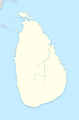
Mahaweli River in Sri Lanka
{{resolved}}
-

-
 Finished map


- Article(s)
- Request
I need the river outline in a standard blue color for livers on a Sri Lankan Map.
I found some good data for the River in the OpenStreetMap, I accessed a copy of data through this Overpass Turbo site (you can export it in many formats, click the 'Export' button). You can export it in many other tools. VScode fanboy (talk) 16:31, 11 January 2024 (UTC)
- Discussion
- @VScode fanboy: Do you have a particular map in mind? M.Bitton (talk) 17:07, 11 January 2024 (UTC)
- It looks like what you're looking for already exists (please above map). M.Bitton (talk) 00:46, 12 January 2024 (UTC)
- @M.Bitton:I have a map in my mind, a tight blue line for the river and the general Sri Lanka map used throughout Wikipedia.
- I reviewed the attached map, I have a slight feeling that the river in that map is tad incorrect and short. If a complete remake is impossible, please make the river line wider on the given map. In the current version it is hard to see which one is the river and which one is the District line.
- Is there any other place where a fellow can pull-of a big creation using the data from OpenStreetMap?
- Thanks in Advance. VScode fanboy (talk) 18:01, 12 January 2024 (UTC)
- If accuracy is what you're after, then Openstreetmap should be avoided since it's user generated (basically, good enough for streets and the like, but not more than that). I have a database of all the rivers somewhere, I'll look for it. If I can't find it, I'll create a new map based on the one that I linked to. M.Bitton (talk) 20:41, 12 January 2024 (UTC)
- @M.Bitton I believe openstreetmap is good for my needs, I personally know the tracing of the mahaweli River done on a electric boat.
- Please continue doing it either from the database or the map you linked (the linked map has a data source, look in to it too?)
- Thanks VScode fanboy (talk) 16:47, 13 January 2024 (UTC)
- If accuracy is what you're after, then Openstreetmap should be avoided since it's user generated (basically, good enough for streets and the like, but not more than that). I have a database of all the rivers somewhere, I'll look for it. If I can't find it, I'll create a new map based on the one that I linked to. M.Bitton (talk) 20:41, 12 January 2024 (UTC)
SVG locator map of Contiguous United States
{{resolved}} SVG locator maps of Contiguous United States in the gray and green globe scheme
-
 Orthographic map of the contiguous United States
.svg)
- Article(s)
- Contiguous United States
- Request
- Create SVG locator maps of Contiguous United States in the gray and green globe scheme. Basically this one but without alaska. — Preceding unsigned comment added by DREAMYTUKAM (talk • contribs) 05:21, 25 January 2024 (UTC)
- Discussion
- Request taken by M.Bitton (talk) 16:02, 27 January 2024 (UTC).
- Done in case you or someone else wants to create a derivative: the states have a CSS class attached to them. The class for each state is a combination, in lower case, of
us-and the two-letter code of the state (for example, if you want to colour Alaska, you would useus-ak). M.Bitton (talk) 16:25, 28 January 2024 (UTC)
Request distribution map for Menemerus animatus

- Article(s)
- Menemerus animatus
- Request
- Please can we have an image showing the distribution of this species, including Algeria, Egypt, Greece, Iraq, Mali, Mauritania, Saudi Arabia, Senegal, Sudan, Turkey and Yemen (as detailed in the article section titled Distribution and habitat). The article is under review for Good Article status by Esculenta, who recommended me check you out.-- simongraham (talk) 19:35, 22 January 2024 (UTC)
- Discussion
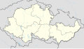
Request: Protectorate of Bohemia and Moravia
-
 Finished map

- Article(s)
- Government Army (Bohemia and Moravia)
- Request
- Hello. Would anyone be willing to create a Locator Map of the Protectorate of Bohemia and Moravia (see existing boundary map here, for reference: [1])? The borders are vaguely similar - but not exactly - to the contemporaneous Czech Republic (see an existing locator map for the CZ Republic here [2]). Presently, I'm stuck using maps of the Czech Republic for articles on the Protectorate like some kind of peasant. While, specifically, I intend to use it on the above article to replace the current map, there are a couple other Protectorate-related articles I'm working on for which it would be extremely useful. Thank you, in advance, for your consideration! I will owe you! Chetsford (talk) 19:02, 20 February 2024 (UTC)
- Discussion
- Hi @Chetsford, there isn't a possibility that you have a map from an RS or otherwise? The sourcing on the map you linked is a bit dubious (i.e. non-existent). – Isochrone (Talk) 19:17, 26 February 2024 (UTC)
- Is this appropriate to use? – Isochrone (Talk) 19:32, 26 February 2024 (UTC)
- Request taken., I'll try to do this one throughout the week, but I might have to do it over the weekend. – Isochrone (Talk) 22:10, 26 February 2024 (UTC)
- Isochrone - sorry for my delayed reply and thank you for checking the sourcing (or lack thereof), I hadn't even bothered to look myself! But yes, the map you found is absolutely perfect (just the parts in blue). Thanks a million, I owe you!!! Chetsford (talk) 05:26, 27 February 2024 (UTC)
- @Chetsford, here is a draft version I have made. What changes would you like? Would you like the map radius to be changed, boundaries hidden, etc.? – Isochrone (Talk) 19:35, 27 February 2024 (UTC)
- Isochrone - sorry for my delayed reply and thank you for checking the sourcing (or lack thereof), I hadn't even bothered to look myself! But yes, the map you found is absolutely perfect (just the parts in blue). Thanks a million, I owe you!!! Chetsford (talk) 05:26, 27 February 2024 (UTC)
- Is this appropriate to use? – Isochrone (Talk) 19:32, 26 February 2024 (UTC)
![[1]](https://en.wikipedia.org/wiki/Protectorate_of_Bohemia_and_Moravia#/media/File:Protectorate_Of_Bohemia_and_Moravia.png)
![[2]](https://en.wikipedia.org/wiki/File:Relief_Map_of_Czech_Republic.png)
- Hi Chetsford, please see File:Protectorate of Bohemia and Moravia adm location map.svg. I've made a location map module so if you enter
Czech Republic Protectorate of Bohemia and Moraviainstead of justCzech Republicinto any location map template it should update it as appropriate. Hopefully this is helpful! – Isochrone (talk) 18:19, 1 March 2024 (UTC)
OpenStreetMap request for Paul Huff Parkway
- Article(s)
- Paul Huff Parkway
- Request
- I am requesting that an OpenStreetMap for Paul Huff Parkway, a current GA nominee that is in the process of being reviewed, be created. -- Bneu2013 (talk) 05:28, 6 March 2024 (UTC)
- Discussion
- @Bneu2013 how does the map now look? – Isochrone (talk) 10:12, 7 March 2024 (UTC)